Plan Wien: First Edition (11 results)

Published by Karthographie Berndt, Wien 1982
- First Edition
- Map
Seller: Historia, Regnum et Nobilia, BATTIPAGLIA, SA, ItalyHistoria, Regnum et Nobilia
Contact seller4-star sellerCondition: Used - Fine
US$ 9.55
US$ 23.18 shippingShips from Italy to U.S.A.Quantity: 1 available
senza rilegatura. Condition: ottimo. prima edizione. Grande mappa a colori di Vienna.

- Softcover
- First Edition
Seller: Xerxes Fine and Rare Books and Documents, Glen Head, NY, U.S.A.Xerxes Fine and Rare Books and Documents
Contact seller5-star sellerCondition: Used - Good
US$ 45.00
US$ 5.95 shippingShips within U.S.A.Quantity: 1 available
Condition: Good. Wien 1857 first edition. Braumuller. Octavo wraps. In German. Zappert article on pp. 399-444 with foldout line drawing map of Wien. other articles in each issue as well. Covers toned and chipped;backstrip reinforced; binding secure; text clean; no owner marks. Good .
Language: German
Published by Wien, Böhlau, 1964
- Softcover
- First Edition
Seller: Matthaeus Truppe Antiquariat, Graz, , AustriaMatthaeus Truppe Antiquariat
Contact seller5-star sellerCondition: Used
US$ 15.52
US$ 71.87 shippingShips from Austria to U.S.A.Quantity: 1 available
Gr.-8°. OKart. (Gebrssprn.). 41 S. (= Österreichische Akademie der Wissenschaften. Philosophisch-Historische Klasse. Sitzungsberichte. Bd. 243, 3. Abh.). - Papierbedingt leicht gebräunt. *** *** Copyright: Matthaeus TRUPPE Buchhandlung & Antiquariat - Stubenberggasse 7 - A-8010 Graz - ++43 (0)316 - 829552 *** *** Sprache: Deutsc…h Gewicht in Gramm: 100.
Published by Wien, Selbstverlag u. Leopold Sommer, 1863. 1863
- Hardcover
- First Edition
Seller: Antiquariat INLIBRIS Gilhofer Nfg. GmbH, Vienna, A, AustriaAntiquariat INLIBRIS Gilhofer Nfg. GmbH
Contact seller5-star sellerCondition: Used
US$ 537.28
US$ 34.78 shippingShips from Austria to U.S.A.Quantity: 1 available
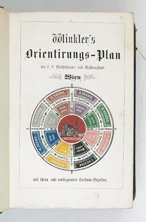
(2), 5, (1), (2), XXIX, (3), (4), (2), 211, (1), (4), (4) SS., SS. 9-1128. Halblederband der Zeit mit goldgepr. Rückentitel. 8vo. Erste Ausgabe des in Einzelheften vertriebenen und vollständig wie vorliegend höchst seltenen Hauptwerks des ehemaligen Schildermalers und späteren Industriellen. Winkler konzipierte das 1862 in Wien…eingeführte und in modifizierter Form bis heute gültige Hausnummern- und Straßenbeschriftungssystem. Sein hier vorliegendes Orientierungsschema mit entsprechenden Planbeilagen, das die alten und die neuen Nummern enthält, ist "noch heute für die Umrechnung von alten Hausnummern unentbehrlich" (Czeike). - Ohne die Pläne. - Czeike IV, 662. Nicht Slg. Mayer.
Published by Wien, Artaria 1819. 1819
- Hardcover
- First Edition
Seller: Antiquariat Löcker, Wien, , AustriaAntiquariat Löcker
Contact seller5-star sellerCondition: Used
US$ 716.38
US$ 84.04 shippingShips from Austria to U.S.A.Quantity: 1 available
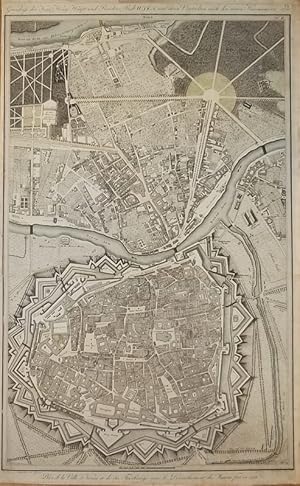
Erste Ausgabe. Dörflinger S. 412; 104. Ca 58,5 x 73 cm. Gefalteter, kolorierter Kupf.-Plan, in 18 Segmenten auf Lwd., in zeitgenöss. Kartonschuber, dieser berieben.

Language: German
- Hardcover
- First Edition
- Art Print
Seller: Antiquariat Clemens Paulusch GmbH, Berlin, , GermanyAntiquariat Clemens Paulusch GmbH
Contact seller5-star sellerCondition: Used
US$ 656.68
US$ 31.18 shippingShips from Germany to U.S.A.Quantity: 1 available
altkol. Kupferstich b. Artaria Wien, 1844, 60 x 75 Vergl. Dörflinger, Öst. Karten des frühen 19. Jahrhunderts, p. 412, Art 104 (Erstausgabe der Karte 1819); Dekorativer Plan der Inneren Stadt, erstmals 1819 vor Vollendung des Volks- und Kaisergartens erschienen, die vier Viertel der Inneren Stadt (Kärntner-Viertel, Schotten-Vier…tel, Wimmer-Viertel und Stuben-Viertel) sind farblich gekennzeichnet, im Vergleich zu früheren Ausgaben mit einigen Aktualisierungen (zum Beispiel das Paradeisgartel auf der Löwelbastei fehlt bei den frühen Ausgaben 1819 oder 1821; zerschnitten und auf Leinen aufgezogen, in Pappschuber der Zeit.
 More images
Language: German
Published by Wien, Riedl, 1825
- First Edition
- Map
Seller: Matthaeus Truppe Antiquariat, Graz, , AustriaMatthaeus Truppe Antiquariat
Contact seller5-star sellerCondition: Used
US$ 799.48
US$ 71.87 shippingShips from Austria to U.S.A.Quantity: 1 available
Ca. 49 cm x 55 cm. Sehr seltener thematischer Plan der Wiener Innenstadt auf Grundlage des 1821 lithographierten "Grundriss der inneren Stadt Wien" (vgl. Dörflinger Rie 63) mit der seit 1821 gültigen neuen Nummerierung der Liegenschaften. - Schwarz-roter Druck. - Allseitig knapp bis in den Plattenrand beschnitten. Papierbedingt…leicht gebräunt. *** *** Copyright: Matthaeus TRUPPE Buchhandlung & Antiquariat - Stubenberggasse 7 - A-8010 Graz - ++43 (0)316 - 829552 *** *** Sprache: Deutsch Gewicht in Gramm: 500.

- First Edition
- Map
Seller: Geographicus Rare Antique Maps, Brooklyn, NY, U.S.A.Geographicus Rare Antique Maps
Contact seller4-star seller1st Edition. Very good. Dissected and laid on linen. Light toning and foxing along folds. Size 39 x 33.25 Inches. This 1897 chromolithographed large-format folding map of Vienna was prepared by Freytag and Berndt for publication by A. Hartleben's Verlag. It presents the city during a period of drastic transformation when it had…become one of the most dynamic intellectual and artistic centers in the world. A Closer Look Vienna is displayed as divided into Bezirke (districts), noted with bold blue lines and labeled with blue text. The city's boundaries had expanded and its districts were reorganized in the early 1890s (the 'Neuen Bezirkseintheilung' referred to in the subtitle), with suburbs beyond the city's former outer wall (Linienwall) becoming districts 11-19, explaining their odd boundaries here which resemble the jagged lines of fortifications. The reorganization was necessary as the city's population grew consistently across the 19th century, roughly 20-30% each decade after the conclusion of the Napoleonic Wars (1803 - 1815). Drawing a wide range of peoples from throughout the Austro-Hungarian Empire, Vienna was at this time the third or fourth largest city in Europe, behind only Paris, London, and Berlin. The map provides extensive detail on several classes of streets and roads, as well as railways, canals, churches and religious sites, graveyards, parks, gardens, markets, palaces, military facilities, and more, as well as fields, farms, and vineyards on the outskirts of the city. Areas of planned construction are ghosted in with dashed lines, as in the city's 11th District, Simmering, at bottom-right (its Central Friedhof cemetery is still one of the largest in Europe). Fin-de-siècle Vienna Vienna at this time was one of the most vibrant cities in Europe, with opulent Neoclassical structures, wide tree-lined boulevards, booming industry, excellent public transportation (including the Wiener Stadtbahn, influenced by the London Underground, noted as in the 'first construction period' at this time), a thriving arts scene, and a colorful, cosmopolitan mix of ethnicities and cultures from throughout the Austo-Hungarian Empire. The city had been largely remade in the second half of the 19th century, with the Danube River channeled and regulated by dams, canals, and levees, and the old (inner) city walls being replaced by wide boulevards collectively known as the Ringstrasse , which was lined with majestic buildings for government ministries, cultural institutions, and palaces for the nobility, built in a Neoclassical style that came to be known as Ringstrassenstil. The reduction of the old city walls and their replacement with the Ringstrasse and its associated structures was not completed until 1913, by which time Ringstrassenstil had become passé and was replaced by more innovative designs driven by members of the Art Nouveau (Jugendstil)-affiliated Vienna Secession movement such as Otto Wagner (1841 - 1918, who had also designed the beautiful Karlsplatz Stadtbahn Station). The zeitgeist of fin-de-siècle Vienna was retroactively summarized by Stefan Zweig in his memoir The World of Yesterday ( Die Welt von Gestern ) thus: the genius of Vienna, a specifically musical genius, had always been that it harmonized all national and linguistic opposites in itself, its culture was a synthesis of all Western cultures. Anyone who lived and worked there felt free of narrow-minded prejudice. Nowhere was it easier to be a European Such a dynamic, bubbling mix of cultures, technologies, and ideas germinated a broad range of innovators, including - in addition to Wagner and Zweig - Sigmund Freud, Gustav Mahler, and Gustav Klimt, among others. In their wake, even more avant-garde forms of thought and expression would take root in the city, including the works of philosopher Ludwig Wittgenstein, artist Oskar Kokoschka, and composer Arnold Schoenberg. All was not well in Vienna, however, and the decadence of the era was counterbalanced by social up.
 More images
Language: German
Published by Wien : Creditanstalt-Bankverein ca. 1958. 1958
- First Edition
Seller: Antiquariat REDIVIVUS, Regensburg, GermanyAntiquariat REDIVIVUS
Contact seller5-star sellerCondition: Used - Fine
US$ 17.91
US$ 115.92 shippingShips from Germany to U.S.A.Quantity: 1 available
(° 39,5 x 35 cm Faltkarte. Condition: Sehr gut. 1. Auflage. 1 Faltkarte farbig 2 Blatt SELTENES EXEMPLAR !!!! 9400 Ordner Sprache: Deutsch Gewicht in Gramm: 500.

Language: German
Published by Prag, 1823
- First Edition
- Map
Seller: Matthaeus Truppe Antiquariat, Graz, , AustriaMatthaeus Truppe Antiquariat
Contact seller5-star sellerCondition: Used
US$ 361.05
US$ 71.87 shippingShips from Austria to U.S.A.Quantity: 1 available
Schöner Grundrißplan der Stadt Wien aus dem Jahr 1823 mit Schönbrunn, Praterauen und umfangreicher Legende. - Papierbedingt leicht gebräunt. Linker Rand zur Hälfte bis in den Plattenrand knapp beschnitten. Mehrfache Knickfalten. *** *** Copyright: Matthaeus TRUPPE Buchhandlung & Antiquariat - Stubenberggasse 7 - A-8010 Graz - ++…43 (0)316 - 829552 *** *** Sprache: Deutsch Gewicht in Gramm: 500 Ca. 36 cm x 53 cm (Platte), 39 cm x 45 cm (ganze Blatt).
Language: German
- First Edition
- Map
Seller: Matthaeus Truppe Antiquariat, Graz, , AustriaMatthaeus Truppe Antiquariat
Contact seller5-star sellerCondition: Used
US$ 1,225.01
US$ 71.87 shippingShips from Austria to U.S.A.Quantity: 1 available
Ca. 75 cm x 46 cm. Einer der ersten Stadtpläne von Wien mit genauer Bezeichnung der Straßen und Hausnummern. - Maßstab ca. 1: 4.400 . - Allseitig knapp beschnitten, am unteren Rand ein Teil des Textes beschnitten. Etw. gebräunt und fleckig. *** *** Copyright: Matthaeus TRUPPE Buchhandlung & Antiquariat - Stubenberggasse 7 - A-80…10 Graz - ++43 (0)316 - 829552 *** *** Sprache: Deutsch.


