Rhode Island County Map (39 results)

Published by Rand, McNally & Co., Chicago & New York 1899
- Softcover
Seller: Willis Monie-Books, ABAA, Cooperstown, NY, U.S.A.Willis Monie-Books, ABAA
Contact seller5-star sellerCondition: Used - Very good
US$ 37.50
US$ 8.00 shippingShips within U.S.A.Quantity: 1 available
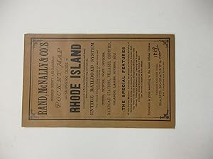
Softcover. Condition: Very Good. Front cover has a very small chip to the upper outer corner. ; Also ".showing in detail the entire railroad system ." Map and twenty pages of text and ads attached to paper covers. Covers approx. 4 1/8" wide by 6 1/2". ; 20 + map pages.

Published by Rand McNally & Co, Chicago and New York 1892
- Softcover
Seller: McBlain Books, ABAA, Hamden, CT, U.S.A.McBlain Books, ABAA
Contact seller5-star sellerCondition: Used - Very good
US$ 40.00
US$ 5.00 shippingShips within U.S.A.Quantity: 1 available
Paperback. Condition: Very Good. folding map (inside back cover), 30p. Softcover in original light brown wrapper. 17 cm. Clean copy.
 More images
Published by F.W. Beers, Rhode Island 1870
- Map
Seller: biblioboy, North Providence, RI, U.S.A.biblioboy
Contact seller5-star sellerCondition: Used - Good
US$ 40.00
US$ 7.00 shippingShips within U.S.A.Quantity: 1 available
Map. Condition: Good. Original 1870 Rhode Island Map. Hopkinton, Washington County, Rhode Island. Hand colored. The map including margins is 14.5 x 11.75 inches, 14 x 16.5 inches without margins, was taken from the Atlas of the State of Rhode Island and Providence Plantations by F.W. Beers. 1870. The map includes the communities… of Barberville, Moscow, Grassy Pond, Rockville, Centreville, Ashville, Hope Valley, Wyoming, Locustville, Hopkinton City, Woodville, Ashaway, Laureldale, Burdickville, Potters Hill and more. On the side of the map is the Ashville Subscribers' Directory- Lafayette Edwards, Manufacturer of Cotton Warps and others. A wonderful, original, antique map. Condition: Light dust soiling and age toning, a tiny light damp stain to the bottom left corner. There is chipping to the margins, not affecting the image. See Photos LRrightE. F.W. Beers (illustrator).

Published by Mitchel, S. Augustus, Philadelphia 1870
- Map
Seller: mediumraremaps.com, Franklin, TN, U.S.A.mediumraremaps.com
Contact seller4-star sellerCondition: Used - Very good
US$ 55.00
US$ 6.00 shippingShips within U.S.A.Quantity: 1 available
14 x 11 1/4. Condition: Very good. Nice small scale presentation of the three states. Hand colored in outline complemented by wash coloring defining the enclosed counties. Railroad lines dominate the presentation with the coastlines defined in deep dark ink. A fine cartographic presentation of the region.
 More images
Published by Buffalo: P.J. Hannifan & Co. 1898
- Hardcover
Seller: Centerbridge Books, Old Saybrook, CT, U.S.A.Centerbridge Books
Contact seller5-star sellerCondition: Used - Good
US$ 100.00
US$ 5.00 shippingShips within U.S.A.Quantity: 1 available
Hardcover. Condition: Good. Printed red cloth. Tall octavo. 496pp. Folding map. Contains numerous engraved ads for businesses in these two states as well as a large color folding map showing townships and railroads. The map measures 24 by 32 inches. A good copy with some rubbing and wear to the covers and some fraying to the spi…ne tips and cover corners. The text is good with some light soiling and wear. The map is in very good condition with minor wear.

Published by S. Augustus Mitchell, Philadelphia 1867
- Map
Seller: mediumraremaps.com, Franklin, TN, U.S.A.mediumraremaps.com
Contact seller5-star sellerCondition: Used - Very good
US$ 75.00
US$ 6.00 shippingShips within U.S.A.Quantity: 1 available
13 5/8 x 11 1/2 inches. Condition: very good condition. Three state map showing post Civil War rail networks. Overall a nice presentation of the era of westward expansion with the infilling of interstices of transportation. This map belongs in all collections of the New England States.

Published by George F. Cram, Chicago 1899
- Map
Seller: mediumraremaps.com, Franklin, TN, U.S.A.mediumraremaps.com
Contact seller5-star sellerCondition: Used - Very good
US$ 75.00
US$ 6.00 shippingShips within U.S.A.Quantity: 1 available
24 3/4 x 16 3/4 inches. Condition: Very good. Beautifully executed map showing the railroad network in these two northeastern states. The ports of Boston and Providence have a concentration of railroads. This area was the cradle of early railroad development in the United States. There is a listing and color key to all the railr…oads. There is also an inset map of Boston. This is a quite decorative antique map.

Seller: Art Source International Inc., Boulder, CO, U.S.A.Art Source International Inc.
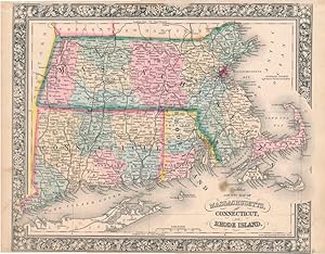
Contact seller5-star sellerThis detailed, double-page map of the states of Massachusetts, Connecticut, and Rhode Island was printed in the "People's Family Atlas of the World," published in 1885. This map, which shows a great deal of topographical information, including lakes, rivers and mountains, has all counties outlined in green and state bounderies o…utlined in pink. This map measures 20.5 inches by 13.25 inches.
Published by S. Augustus Mitchell, Jr., New York 1862
- Map
Seller: Main Street Fine Books & Mss, ABAA, Galena, IL, U.S.A.Main Street Fine Books & Mss, ABAA
Contact seller5-star sellerFolio (15¼" X 12¼", image area 14" X 11½"). Hand colored. Very good. Lightly age toned and faintly soiled ; single small discreet stain. Nice example of this tri-state county map, from the 1864 edition of "Mitchell's New General Atlas, Containing Maps of the Various Countries of the World, Plans of Cities, Etc." Well colored and… with sharp floral border.

Published by S. Augustus Mitchell, Jr., New York 1862
- Map
Seller: Main Street Fine Books & Mss, ABAA, Galena, IL, U.S.A.Main Street Fine Books & Mss, ABAA
Contact seller5-star sellerFolio (15¼" X 12¼", image area 14" X 11½"). Hand colored. Very good. Faint age toning only. Handsome example of this tri-state county map, from the 1864 edition of "Mitchell's New General Atlas, Containing Maps of the Various Countries of the World, Plans of Cities, Etc." Sharp, bright coloring and with handsome decorative borde…r.
 More images
Published by Chicago and New York 1889
Seller: David M. Lesser, ABAA, Woodbridge, CT, U.S.A.David M. Lesser, ABAA
Contact seller5-star seller4" x 6.5." Original printed wrappers, stitched. 14pp + attractive color folding map at rear. Very Good.

Seller: Art Source International Inc., Boulder, CO, U.S.A.Art Source International Inc.
Contact seller5-star sellerThis map was made by S. Augustus Mitchell for "Mitchell's New General Atlas" published in 1887. The well maintained maps in this atlas feature Mitchell's characteristic pastel coloring and abundant details of geographical features. Massachusetts, Connecticut and Rhode Island are illustrated on this map. Details include the names… of counties, important towns, rivers, mountains, lakes, and railroads. Counties are distinguished by color. These 1887 maps offer a fascinating perspective of areas that have since undergone significant growth and change, in addition to their value as great examples of Mitchell's work. This map has water stains in the margin that do not affect the map. This map measures 21.25 inches by 14.5 inches.

Seller: Art Source International Inc., Boulder, CO, U.S.A.Art Source International Inc.
Contact seller5-star sellerThe Mitchell company was one of the first to try out the new technique of engraving on steel plates, experimenting with steel almost 20 years before the rest of the publishing industry. He was printing with steel in the early 1830s; the general switch to steel was approximately 1850. During the early years of the company, Mitche…ll published mainly maps and travel guides. In 1860, Mitchell started producing "Mitchell's New General Atlas",and Mitchell Sr. retired and turned the business over to his son of the same name. The New General Atlas was published until 1893. Today Mitchell maps are sought after for their fine engraving, bright coloring, and attention to detail. They are some of the finest maps produced in the 1860's. This map produced in 1867, has Mitchell's unique floral border, and beautiful hand coloring.This map details the states of County Map of Massachusetts, Connecticut and Rhode Island. Counties, cities, towns, lakes, rivers and transportation routes are noted. This map measures 10.5 inches by 13.5 inches.

Seller: Art Source International Inc., Boulder, CO, U.S.A.Art Source International Inc.
Contact seller5-star sellerThis map was made by S. Augustus Mitchell for "Mitchells New General Atlas" published in 1884, by WM. M. Bradley & Co. The well maintained maps in this atlas feature Mitchell's characteristic pastel coloring and abundant geographical features. Details include the names of counties, cities, towns, transportation routes, rivers, l…akes, and mountain ranges. Regions are distinguished by color. These 1884 maps offer a fascinating perspective of areas that have since undergone significant growth and change, in addition to their value as great examples of Mitchell's work. This map measures 21 inches by 14 inches.

Seller: Art Source International Inc., Boulder, CO, U.S.A.Art Source International Inc.
Contact seller5-star sellerThis map came from Mitchells New General Atlas, 1881. The traditional ivy border, and hand coloring make this map beautiful. This double page, US State map shows transportation routes, rivers, towns, and topography features. Very Detailed!' This map measures 21.25 inches by 14.25 inches.

Seller: Art Source International Inc., Boulder, CO, U.S.A.Art Source International Inc.
Contact seller5-star sellerThe Mitchell company was one of the first to try out the new technique of engraving on steel plates, experimenting with steel almost 20 years before the rest of the publishing industry. He was printing with steel in the early 1830s; the general switch to steel engraving was approximately 1850. During the early years of the compa…ny, Mitchell published mainly maps and travel guides. In 1860, Mitchell started producing "Mitchell's New General Atlas". Mitchell Sr. retired and turned the business over to his son of the same name. The New General Atlas was published until 1893. Today Mitchell maps are sought after for their fine engraving, bright coloring, and attention to detail. They are some of the finest maps produced in the 1860's. This map, produced in 1863, shows Mitchell's famous flower border, which is only seen in the early editions of his atlases. This map shows New York, New Hampshire, Vermont, Massachusetts, and Rhode Island. This map measures 22 inches by 17 inches.

Seller: Art Source International Inc., Boulder, CO, U.S.A.Art Source International Inc.
Contact seller5-star sellerA very detailed contour map of Rhode Island including the towns of North Smithfield, Woonsocket, Smithfield, Johnston, Cranston, Providence including North and East, and Pawtucket. This highly informative map pays particular attention to major buildings, railroads and mills. This map measures 13 inches by 19 inches.

Seller: Art Source International Inc., Boulder, CO, U.S.A.Art Source International Inc.
Contact seller5-star sellerThis map was produced by Augustus Mitchell in 1878 for his New General Atlas. Highlights of this map are Mitchells traditional grapevine border, characteristic pastel coloring and abundant details of geographical features. The States of Massachusetts, Connecticut and Rhode Island are illustrated on this map. Counties are disting…uished by color. This 1878 map offers a fascinating perspective of areas that have since undergone significant growth and change, in addition to the value as great examples of Mitchell's classic mapmaking style. This map measures 21 inches by 14 inches.

Seller: Art Source International Inc., Boulder, CO, U.S.A.Art Source International Inc.
Contact seller5-star sellerhis map was made by S. Augustus Mitchellin 1872. The well maintained maps in this atlas feature Mitchells characteristic pastel coloring and abundant details of geographical features. Massachusetts, Connecticut and Rhode Island are illustrated on this map. Details include the names of counties, important towns, rivers, mountains…, lakes, and railroads. Counties are distinguished by color. These 1887 maps offer a fascinating perspective of areas that have since undergone significant growth and change, in addition to their value as great examples of Mitchell's work. This map measures 14 inches by 11.5 inches.

Seller: Art Source International Inc., Boulder, CO, U.S.A.Art Source International Inc.
Contact seller5-star sellerThe Mitchell company was one of the first to try out the new technique of engraving on steel plates, experimenting with steel almost 20 years before the rest of the publishing industry. He was printing with steel in the early 1830s; the general switch to steel engraving was approximately 1850. During the early years of the compa…ny, Mitchell published mainly maps and travel guides. In 1860, Mitchell started producing "Mitchell's New General Atlas". Mitchell Sr. retired and turned the business over to his son of the same name. The New General Atlas was published until 1893. Today Mitchell maps are sought after for their fine engraving, bright coloring, and attention to detail. They are some of the finest maps produced in the 1860's. This map produced in 1863, shows Mitchell's famous flower border, which is only seen in the early editions of his atlases. This map shows Massachusetts, Connecticut, and Rhode Island. This map measures 14 inches by 12 inches.

Seller: Art Source International Inc., Boulder, CO, U.S.A.Art Source International Inc.
Contact seller5-star sellerThis map of Massachusetts, Connecticut, and Rhode Island was made by S. Augustus Mitchell for "Mitchells New General Atlas" published in 1888, by WM. M. Bradley & Co. The well maintained maps in this atlas feature Mitchell's characteristic pastel coloring and abundant details of geographical features. Details include the names o…f counties, cities, towns, transportation routes, mountain ranges, rivers and lakes. These 1888 maps offer a fascinating perspective of areas that have since undergone significant growth and change, in addition to their value as great examples of Mitchell's work. This map measures 21.5 inches by 14 inches.

Seller: Art Source International Inc., Boulder, CO, U.S.A.Art Source International Inc.
Contact seller5-star sellerThis hand colored map was made for "Mitchells New General Atlas" published in 1877 by S. Augustus Mitchell. Massachusetts, Connecticut, and Rhode Island are illustrated on this map. Counties are highlighted by color. Other details include the names of counties and important cities, and illustrations of rivers, lakes, and major r…oads. This map measures 21.5 inches by 14 inches.
Published by National Publishing Company, Boston 1902
Seller: Nat DesMarais Rare Books, ABAA, Portland, OR, U.S.A.Nat DesMarais Rare Books, ABAA
Contact seller4-star sellerLarge color map of the tri-state area; 36 x 38 inches. Linen-backed as issued. Folding into the publisher's brown cloth portfolio with bright gilt lettering and frame. Two corners of the cloth lightly bumped but an excellent copy.

Seller: Art Source International Inc., Boulder, CO, U.S.A.Art Source International Inc.
Contact seller5-star sellerIn 1860 S. Augustus Mitchell Jr. took over his father's map publishing business and in that year he started publishing Mitchell's New General Atlas. Editions of the new general were issued annually until 1887. Mitchell Jr. continued publishing this atlas until 1879. The editions from 1880 to 1887 were published by Wm. M. Bradley…. This map published in 1865 is a wonderful example of Mitchell's map-making prowess with beautiful original hand-coloring. This map measures 13.5 inches by 10.5 inches.

Seller: Art Source International Inc., Boulder, CO, U.S.A.Art Source International Inc.
Contact seller5-star sellerIn 1860 S. Augustus Mitchell Jr. took over his father's map publishing business and in that year he started publishing Mitchell's New General Atlas. Editions of the new general were issued annually until 1887. Mitchell Jr. continued publishing this atlas until 1879. The editions from 1880 to 1887 were published by Wm. M. Bradley…. This map published in 1865 is a wonderful example of Mitchell's map-making prowess with beautiful original hand-coloring. This map measures 21 inches by 13.5 inches.

Seller: Art Source International Inc., Boulder, CO, U.S.A.Art Source International Inc.
Contact seller5-star sellerThis map was made by S. Augustus Mitchell for "Mitchells New General Atlas" published in 1885, by WM. M. Bradley & Co. The well maintained maps in this atlas feature Mitchell's characteristic pastel coloring and abundant details of geographical features. Details include the names of counties, cities, towns, transportation routes…, rivers and lakes. These 1885 maps offer a fascinating perspective of areas that have since undergone significant growth and change, in addition to their value as great examples of Mitchell's work. This map measures 14.5 inches by 20.5 inches.

Seller: Art Source International Inc., Boulder, CO, U.S.A.Art Source International Inc.
Contact seller5-star sellerThis hand colored map was made for "Mitchells New General Atlas" published in 1868 by S. Augustus Mitchell, Jr. Massachusetts, Connecticut, and Rhode Island are illustrated on this map. Counties are distinguished by color. Other details include the names of states, counties, and important cities, railroads, major roads,and river…s. The pastel coloring in this atlas is very beautiful and more muted than typical. This map measures 14 inches by 11.5 inches.

Seller: Art Source International Inc., Boulder, CO, U.S.A.Art Source International Inc.
Contact seller5-star sellerThe Mitchell company was one of the first to try out the new technique of engraving on steel plates experimenting with steel almost 20 years before the rest of the publishing industry. He was printing with steel in the early 1830s; the general switch to steel was approximately 1850. During the early years of the company, Mitchel…l published mainly maps and travel guides. In 1860, Mitchell started producing "Mitchell's New General Atlas",and Mitchell Sr. retired and turned the business over to his son of the same name. The New General Atlas was published until 1893. Today Mitchell maps are sought after for their fine engraving, bright coloring, and attention to detail. They are some of the finest maps produced during this time period. This map produced in 1866, has Mitchell's unique floral border, and beautiful hand coloring. This map details the states of Massachusetts, Connecticut, and Rhode Island. Counties, cities, towns, lakes, rivers, mountains, and transportation routes are noted. Each map was printed on thick paper with vibrant hand color. This map measures 11.5 inches by 14 inches.

Seller: Art Source International Inc., Boulder, CO, U.S.A.Art Source International Inc.
Contact seller5-star sellerThis black and white engraving shows a map of Rhode Island and Block Island. It was issued as part of the "History of the State of Rhode Island", published in 1874, by Hoag, Wade & Co., Philadelphia, Pennsylvania. The images from this collection capture the romantic history of many important homes, businesses, churches and landm…arks in 1878 Rhode Island. This map measures 8.75 inches by 11 inches.

Seller: Art Source International Inc., Boulder, CO, U.S.A.Art Source International Inc.
Contact seller5-star sellerS. Augustus Mitchell,Jr. made this hand colored map for Mitchells New General Atlas in 1870. This map illustrates Massachusetts, Connecticut, and Rhode Island. Counties are distinguished by bright pastel colors. Other details include the names of counties, important cities, railroads, proposed railroads, and major roads. This ma…p measures 14 inches by 11.5 inches.


