
Order Total (1 Item Items):
Shipping Destination:

Road Dublin Sligo Longford by Taylor Skinner (7 results)
Skip to main search results
Product Type
- All Product Types
- Books
- Magazines & Periodicals
- Comics
- Sheet Music
- Art, Prints & Posters
- Photographs
- Maps (7)
-
Manuscripts &
Paper Collectibles
Condition
- All Conditions
- New
- Used
Binding
- All Bindings
- Hardcover
- Softcover
Collectible Attributes
- First Edition
- Signed
- Dust Jacket
- Seller-Supplied Images
- Not Printed On Demand
Seller Location
Seller Rating
-
Condition: Good. #63 To Sligo by Longford. Edgeworthstown Newtownforbes. TAYLOR/SKINNER 1778 map. Antique copperplate road map; George Taylor & Andrew Skinner (1778). 23.0 x 13.0cm, 9 x 5.25 inches. Condition: Good. There is another map printed on the reverse side: #64 [Road] from Dublin [to Sligo by Longford] which includes the towns of Carrick-on-Shannon, Drumsna, Boyle, Ballinafad, Jamestown and covers part of the counties of Leitrim, Sligo, Roscommon. The map includes the towns of Edgeworthstown, Roosky, Newtownforbes, Longford, Ballinalack, Dromod and covers part of the counties of Longford, Leitrim, Westmeath, Roscommon.
-
Condition: Good. #64 Carrick/Shannon Drumsna Boyle Ballinafad Jamestown. TAYLOR/SKINNER 1778 map. Antique copperplate road map; George Taylor & Andrew Skinner (1778). 23.0 x 13.0cm, 9 x 5 inches. Condition: Good. There is another map printed on the reverse side: #63 [Road from Dublin] to Sligo by Longford which includes the towns of Edgeworthstown, Roosky, Newtownforbes, Longford, Ballinalack, Dromod and covers part of the counties of Longford, Leitrim, Westmeath, Roscommon. The map includes the towns of Carrick-on-Shannon, Drumsna, Boyle, Ballinafad, Jamestown and covers part of the counties of Leitrim, Sligo, Roscommon.
-
Condition: Good. #65 [Road from Dublin] to Sligo by Longford. Collooney. TAYLOR/SKINNER 1778 map. Antique copperplate road map; George Taylor & Andrew Skinner (1778). 23.0 x 13.0cm, 9 x 5.25 inches. Condition: Good. There is another map printed on the reverse side: #66 Road from Dublin to Killala to Roscommon by Lanesboro & to Boyle by Strokestown which includes the towns of Mullingar, Rathconrath and covers part of the county of Westmeath. The map includes the towns of Sligo, Collooney and covers part of the county of Sligo.
-
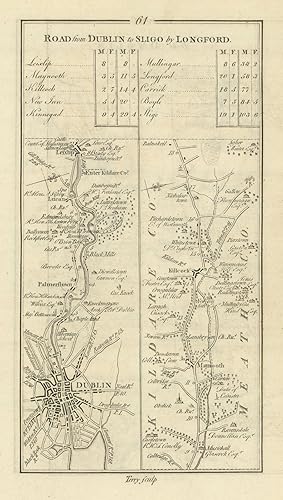
Condition: Good. #61 Dublin to Sligo. Palmerstown Maynooth Kilcock Lucan. TAYLOR/SKINNER 1778 map. Antique copperplate road map; George Taylor & Andrew Skinner (1778). 23.0 x 13.0cm, 9 x 5 inches. Condition: Good. There is another map printed on the reverse side: #62 [Road] from Dublin [to Sligo by Longford] which includes the towns of Kinnegad, Mullingar and covers part of the county of Westmeath. The map includes the towns of Dublin, Palmerstown, Maynooth, Kilcock, Lucan and covers part of the counties of Dublin, Kildare.
-
Condition: Good. #62 Dublin to Sligo by Longford. Kinnegad Mullingar. TAYLOR/SKINNER 1778 map. Antique copperplate road map; George Taylor & Andrew Skinner (1778). 23.0 x 13.0cm, 9 x 5 inches. Condition: Good. There is another map printed on the reverse side: #61 Road from Dublin to Sligo by Longford which includes the towns of Dublin, Palmerstown, Maynooth, Kilcock, Lucan and covers part of the counties of Dublin, Kildare. The map includes the towns of Kinnegad, Mullingar and covers part of the county of Westmeath.
-
![Seller image for Road from Dublin to Sligo by Longford. [and on verso] From Dublin [To Sligo by Longford]. for sale by Robert Frew Ltd. ABA ILAB](https://pictures.abebooks.com/inventory/md/md17237132308.jpg)
Road from Dublin to Sligo by Longford. [and on verso] From Dublin [To Sligo by Longford].
Published by Originally published for the Authors.Sold by T. Longman. London and W. Wilson. Dublin., 1783
Seller: Robert Frew Ltd. ABA ILAB, London, United Kingdom
Association Member: ABA ILAB PBFA
Seller Rating:

Map
(25 x 14.5 cm). Uncoloured. Original copper engraved road maps printed on the recto and in two columns on the verso. Table of distances above maps on the recto. Both sides clean and in good condition.
-
![Seller image for [Road from Dublin] to Sligo by Longford. [and on verso] Road from Dublin to Killala To Roscommon by Lanesboro & to Boyle by Strokestown. for sale by Robert Frew Ltd. ABA ILAB](https://pictures.abebooks.com/inventory/md/md17237132309.jpg)
[Road from Dublin] to Sligo by Longford. [and on verso] Road from Dublin to Killala To Roscommon by Lanesboro & to Boyle by Strokestown.
Published by Originally published for the Authors.Sold by T. Longman. London and W. Wilson. Dublin., 1783
Seller: Robert Frew Ltd. ABA ILAB, London, United Kingdom
Association Member: ABA ILAB PBFA
Seller Rating:
Map
(25 x 14.5 cm). Uncoloured. Original copper engraved road maps printed on the recto and on the verso. Table of distances above map on the verso. Both sides clean and in good condition.
![Seller image for [Road from Dublin] to Sligo by Longford for sale by Antiqua Print Gallery](https://pictures.abebooks.com/inventory/md/md31423935280.jpg)
![Seller image for [Road] from Dublin [to Sligo by Longford] for sale by Antiqua Print Gallery](https://pictures.abebooks.com/inventory/md/md31423937191.jpg)
![Seller image for [Road from Dublin] to Sligo by Longford for sale by Antiqua Print Gallery](https://pictures.abebooks.com/inventory/md/md31423938177.jpg)
![Seller image for [Road] from Dublin [to Sligo by Longford] for sale by Antiqua Print Gallery](https://pictures.abebooks.com/inventory/md/md31423932576.jpg)