Order Total (1 Item Items):
Shipping Destination:

Road Map Iran (9 results)
Skip to main search results
Search filters
Product Type
- All Product Types
- Books (6)
- Magazines & Periodicals (No further results match this refinement)
- Comics (No further results match this refinement)
- Sheet Music (No further results match this refinement)
- Art, Prints & Posters (No further results match this refinement)
- Photographs (No further results match this refinement)
- Maps (3)
- Manuscripts & Paper Collectibles (No further results match this refinement)
Condition Learn more
- New (4)
- As New, Fine or Near Fine (No further results match this refinement)
- Very Good or Good (2)
- Fair or Poor (No further results match this refinement)
- As Described (3)
Binding
Collectible Attributes
- First Edition (1)
- Signed (No further results match this refinement)
- Dust Jacket (No further results match this refinement)
- Seller-Supplied Images (7)
- Not Print on Demand (6)
Language (2)
Price
- Any Price
- Under US$ 25 (No further results match this refinement)
- US$ 25 to US$ 50
- Over US$ 50
Free Shipping
- Free Shipping to U.S.A. (No further results match this refinement)
Seller Location
Seller Rating
-

Creation of Technology Road-Map, A strategic approach to change | A practical study of Tehran-Mashed High Speed Railway in Iran
Language: English
Published by LAP LAMBERT Academic Publishing, 2014
ISBN 10: 3659270458 ISBN 13: 9783659270451
Taschenbuch. Condition: Neu. Creation of Technology Road-Map, A strategic approach to change | A practical study of Tehran-Mashed High Speed Railway in Iran | Majid Babaie Ebrahimabadi | Taschenbuch | 348 S. | Englisch | 2014 | LAP LAMBERT Academic Publishing | EAN 9783659270451 | Verantwortliche Person f�r die EU: preigu GmbH & Co. KG, Lengericher Landstr. 19, 49078 Osnabr�ck, mail[at]preigu[dot]de | Anbieter: preigu.
-
PERSIA - IRAN - MASJID-I-SULAIMAN ROAD MAP C.1949-1954
Language: English
Published by Anglo-Iranian Oil Company, Iran
US$ 1,019.70
US$ 33.00 shipping
Ships from United Kingdom to U.S.A.Quantity: 1 available
Add to basketHardcover. Condition: Good. Date: c.1949-1954. South-West Iran: Khuzestan Province - Masjid-i-Sulaiman oilfield district. Size of map: 99cm x 66cm. Scale: 3 inches to 1 mile. Wear to the fold lines. Minor staining, mainly verso. Has a couple of short, closed tears. A scarce and historically significant Anglo-Iranian Oil Company operational road map, illustrating the infrastructure of the Masjid-i-Sulaiman oilfield during the early 1950s. Combining survey precision, industrial mapping, and logistical planning, it represents a rare survival of working petroleum cartography from a foundational period in the global oil industry. In good condition overall. Please contact us for more a detailed catalogue entry. Very scarce.
-
US$ 373.89
US$ 33.00 shipping
Ships from United Kingdom to U.S.A.Quantity: 1 available
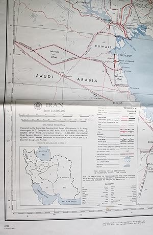
Add to basketSoft cover. Condition: Very Good. 4th Edition. Colour printed paper map 85x85cm. Very good, neatly folded with some creasing and marks. This was originally compiled in 1951, revised for major communications and place names in 1956, and printed by AMS dated 9-64. 1:2,500,000. The main features are land transport links, with numerous grades of principal or other roads (hard surface, loose surface (all or dry weather), track, trail, tunnel, pass) and rail (various gauges), and water features. The map also highlights the widespread territorial uncertainties at this time. The Iran-Pakistan boundary is labelled "Undemarcated". Also undemarcated is a stretch of the Iran-USSR border at Gasan-Kuli. A note states that "The boundaries of Qatar, the Trucial Principalities, and Muscat and Oman have not been defined and therefore have not been shown on this map". However, all 7 of the Emirates are labelled, along with other key locations on the Arabian side of the Gulf, strategic features including oil pipelines and the Saudi Govt Railroad, and undemarcated boundaries for the Neutral Zones and Iraq-Kuwait. The attribution of Gwadar here to Muscat and Oman became outdated in 1958. This comes with an English-Farsi glossary, and inset index map of Iran's internal boundaries.
-

The Hypocrites: A CIA-Mossad Road Map of Iran
Language: English
Published by Createspace Independent Publishing Platform, 2013
ISBN 10: 149037048X ISBN 13: 9781490370484
Seller: THE SAINT BOOKSTORE, Southport, United Kingdom
Seller rating 5 out of 5 stars

US$ 29.24
US$ 20.39 shipping
Ships from United Kingdom to U.S.A.Quantity: Over 20 available
Add to basketPaperback / softback. Condition: New. This item is printed on demand. New copy - Usually dispatched within 5-9 working days.
-

The Hypocrites: CIA/Mossad Road Map to Iran
Language: English
Published by Createspace Independent Publishing Platform, 2017
ISBN 10: 1542862736 ISBN 13: 9781542862738
Seller: THE SAINT BOOKSTORE, Southport, United Kingdom
Seller rating 5 out of 5 stars
US$ 30.18
US$ 22.32 shipping
Ships from United Kingdom to U.S.A.Quantity: Over 20 available
Add to basketPaperback / softback. Condition: New. This item is printed on demand. New copy - Usually dispatched within 5-9 working days.
-
Road Map of Iran.
Published by (Tehran), Sahab Geographic & Drafting Institute / National Iranian Oil Company, 1968., 1968
Seller: Antiquariat INLIBRIS Gilhofer Nfg. GmbH, Vienna, A, Austria
Association Member: ILAB PADA VDA VDAO
Seller rating 5 out of 5 stars
First Edition
Original colour-lithograph map, 585 x 882 mm. In English and Farsi. Legend also in French. First edition. Detailed map of Iran produced by Sahab Geographic & Drafting Institute for the National Iranian Oil Company at a time of rapid industrial development under the rule of Mohammad Reza Pahlavi. Includes portions of Saudi Arabia, Kuwait, Iraq, Turkey, USSR, Afghanistan and Pakistan, indicating national boundaries, major cities, towns and settlements, next to roads, railroads, airports, oilfields, refineries, and pipelines, as well as important hunting and fishing grounds, archaeological sites, ski resorts, thermal spas, casinos and beaches. - Includes a small inset map of Bahrain, an Arabic-English glossary of the most important map terminoloy, and an index to places on the map. Plans of 12 major Iranian cities on the reverse: Tehran, Ahwaz, Isfahan, Shiraz, Abadan, Mashhad, Rasht, Kerman, Tabriz, Kermanshah, Resaiyeh, and Sari. - The Sahab Geographic and Drafting Institute was founded in Tehran in 1935, the first private geographic and mapmaking enterprise in the Middle East. - Very well preserved. - OCLC 5491976.
-
Road Map of Iran Highways - Railways - Airways - Waterways and Distances.
Publication Date: 1960
Seller: Geographicus Rare Antique Maps, Brooklyn, NY, U.S.A.
Association Member: ABAA ESA ILAB
Seller rating 4 out of 5 stars

Map
Very good. Light wear along original fold lines. Booklet cover on verso. Size 18.25 x 30 Inches. This is a 1960 folding road map of Iran, prepared by Abbas Sahab, Iran's most prominent contemporary map publisher. It reflects the heavy investments in infrastructure undertaken by the Shah's government in the preceding years. A Closer Look Iran is presented with red overprint indicating provinces and light blue overprint used to display waterways. True to the title, the main focus is on infrastructure, with roads of several grades, railways, and air routes denoted, along with projected routes of each. Distances by road between cities are written along roads. Cities and towns, oil pipelines, administrative boundaries, and archaeological ruins are also recorded. An inset relief map of Iran appears at left, reflecting the country's famous mountainous terrain, while a large table of distances between cities appears at bottom-left. One curious feature of this map is the inclusion of Bahrain as part of Iran; this was the position of the Shah and the Iranian government at the time, based on the (generally quite indirect) rule of Bahrain by the Safavid and Zand Dynasties in the 17th and 18th centuries. Publication History and Census This map was prepared by Abbas Sahab's Geographical and Drafting Institute in Iran. It is the second ('new') edition of the map, originally published in 1958. Later editions would continue to be published in the early 1980s. The present edition is listed among the holdings of ten institutions in the OCLC. References: OCLC 25416389, 751539810.
-

Road Map of Iran.
Publication Date: 1970
Seller: Geographicus Rare Antique Maps, Brooklyn, NY, U.S.A.
Association Member: ABAA ESA ILAB
Seller rating 4 out of 5 stars
Map
Very good. Light wear along original fold lines, at fold intersections, and along margins. Text and printed photographs on verso. Size 18.75 x 27 Inches. This is a c. 1970 Aziz Hatami pictorial road map of Iran. The map depicts the region from Iraq to Afghanistan and from the Caucasus, the Caspian Sea, and Turkmenistan to the Persian Gulf and the Gulf of Oman. Cities, towns, and villages throughout the country are labeled and connected by varying grades of roads. All roads are illustrated in red, with tarmac roads highlighted by two thick parallel lines connected by crosshatching. Solid, passable dirt roads are marked by two parallel red lines, and third-class roads, which the map advises to use only in dry weather, are marked by a single red line. Dashed lines, signifying tracks and caravan roads, 'should be used sparingly and not at all in winter'. Tehran, the capital of Iran, is marked by two concentric circles, while large red dots signify provincial capitals. Distances between cities are given in miles, and airports, historic sites, and gas stations are also identified. Railways and projected railways are also illustrated, as are Iran's rivers and lakes. The blue dashed lines appear to mark provinces, but there is no clear indication that this is so. The whole is surrounded by photographs of famous sites around Iran, including Persepolis, the Jum'a Mosque in Yazd, the Safavid City in Isfahan, and the Blue Mosque in Tabriz. Publication History and Census This map was designed by Aziz Hatami and published by the General Department of Publications and Broadcasting in Iran. Three examples are catalogued in the OCLC as being part of the institutional collections at the University of Pennsylvania, the University of Chicago, and the University of Oxford. This map is rare on the private market. References: OCLC 52664337.
-

Creation of Technology Road-Map, A strategic approach to change : A practical study of Tehran-Mashed High Speed Railway in Iran
Language: English
Published by LAP LAMBERT Academic Publishing, 2014
ISBN 10: 3659270458 ISBN 13: 9783659270451
Taschenbuch. Condition: Neu. nach der Bestellung gedruckt Neuware - Printed after ordering - Technology Road-Mapping is a comprehensive approach to strategic management for integration of market, R&D and technology development into product/service and business aspects. Although rail industry has experienced increased support from government in recent years and it has many advantages over other modes and is known as environmentally friendly, more efficient to national economy and more accepted by social groups, the analysis shows that rail industry has an insufficient market share between all of transport modes. There are many reasons for that but lack of adequate infrastructures and appropriate technologies could be the most important reason. The objective of this project is to create Technology Road-Map for providing appropriate high speed trains technology for Tehran-Mashed railway in Iran. In this project, special consideration has been given to sustainable transportation as economic, social and environmental parameters. The point of departure is a TESP analysis of Iran's macro environment with its structural and economic data.