
Order Total (1 Item Items):
Shipping Destination:

Road Map Utah (17 results)
Skip to main search results
Search filters
Product Type
- All Product Types
- Books (15)
- Magazines & Periodicals (No further results match this refinement)
- Comics (No further results match this refinement)
- Sheet Music (No further results match this refinement)
- Art, Prints & Posters (No further results match this refinement)
- Photographs (No further results match this refinement)
- Maps (2)
- Manuscripts & Paper Collectibles (No further results match this refinement)
Condition Learn more
- New (3)
- As New, Fine or Near Fine (No further results match this refinement)
- Very Good or Good (5)
- Fair or Poor (1)
- As Described (8)
Binding
Collectible Attributes
- First Edition (1)
- Signed (No further results match this refinement)
- Dust Jacket (No further results match this refinement)
- Seller-Supplied Images (13)
- Not Print on Demand (15)
Language (2)
Free Shipping
Seller Location
Seller Rating
-

map. Condition: Good.
-
map. Condition: Very Good. Connecting readers with great books since 1972! Used books may not include companion materials, and may have some shelf wear or limited writing. We ship orders daily and Customer Service is our top priority!
-

MAP: ARIZONA - COLORADO - NEVADA - UTAH - WYOMING ROAD MAP
Published by Tidewater Oil Company, 1956
Seller: David H. Gerber Books (gerberbooks), Austin, TX, U.S.A.
Seller rating 5 out of 5 stars

Folding Map. Condition: Very Good. [small chip to bottom corner of front panel].
-

New Rail Road and County Map of Utah
Language: English
Published by George F. Cram, [Chicago], 1882
Seller: Kaaterskill Books, ABAA/ILAB, East Jewett, NY, U.S.A.
Association Member: ABAA ILAB IOBA
Seller rating 5 out of 5 stars
One sheet (30 x 35 cm). 28.5 x 22.25 cm. (11 1/4 x 8 3/4 inches). Hand colored. Title inside oval cartouche. Scale 36 miles to 1 inch. Taken from "Cram's Illustrated Family Atlas of the World." There were numerous versions of the New Rail Road and County maps by published by Cram and Henry S. Stebbins, with later versions machine colored due to the expense of hand coloring. Phillips 901. Very good, small marginal tear, tiny marginal chip.
-
Paperback. Condition: New.
-
Report of the Secretary of War: Captain Simpson's Report and Map of Wagon Road Routes in Utah Territory
Language: English
Published by US Senate, Washington, 1859
Soft cover. Condition: Very Good. Disbound report, housed in modern clamshell slipcase with leather backstrip, gilt on spine. Report is 84 pages. Sewn binding. Clean copy, text unmarked. Paper toned. Handwritten note in ink at top of first page. Map not included.
-

Rand McNally Junior Auto Road Map of Utah
Publication Date: 1930
Seller: Art Source International Inc., Boulder, CO, U.S.A.
Seller rating 5 out of 5 stars
First Edition
Rand McNally & Company, still a major name in map publishing to this day, began as a small print shop opened in Chicago in 1856 by William H. Rand. The shop originally printed guidebooks and directories. In 1858, Rand hired Andrew McNally who was later to become a partner. Within the next few years, the shop got into the railroad business by starting to print railway tickets and schedules, a key step in the development of the company. The ticket printing led to the publishing of railway guides, and by 1872 Rand McNally and Company had the capacity to publish maps. This road map of Utah came from Rand McNallys Commercial Atlas, sixty-first Edition dated 1930. A highly successful run of atlases that lasted over a decade. This map includes a detailed plan of all existing highways (in red) and all other roads in existance at the time. This map measures 11 inches by 17 inches.
-
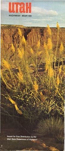
Utah. Official Highway Map State Road Comission of Utha 1968. / Issued for Free Distribution by the Utha State Department of Highways.
Language: English
Publication Date: 1968
Map
aufgefaltet: 47 x 91 cm. Condition: Gut. 1 Karte, beidseitig bedruckt; Sprache: Englisch Gewicht in Gramm: 90.
-

Rand McNally Junior Auto Road Map of Utah
Publication Date: 1932
Seller: Art Source International Inc., Boulder, CO, U.S.A.
Seller rating 5 out of 5 stars
Rand McNally & Company, still a major name in map publishing to this day, began as a small print shop opened in Chicago in 1856 by William H. Rand. The shop originally printed guidebooks and directories. In 1858, Rand hired Andrew McNally who was later to become a partner. Within the next few years, the shop got into the railroad business by starting to print railway tickets and schedules, a key step in the development of the company. The ticket printing led to the publishing of railway guides, and by 1872 Rand McNally and Company had the capacity to publish maps. This map of Utah came from Rand McNallys Commercial Atlas. A highly successful run of atlases that lasted over a decade. These maps were primarily used by business, because of their accurate listing of railroads in operation as well as tables of statistical information. This map is unique in several ways, their large format makes an impressive display, and offers additional room where many small towns and extra details are included. Additionally a list of every railroad operating in the state in 1932 is included. All railroad routes are shown on the map. This map includes all cities and towns, lakes, rivers, and bodies of water. All topographical features are also included as well as political features such as counties and Native American Indian reservations. This map measures 17 inches by 11 inches.
-
![Seller image for [Lot of 9] Texaco Touring Maps; includes Wisconsin, Nebraska, Utah, Nevada, Colorado, Idaho, Washington, Oregon, and California [State Road Map] [Circa late 1930's - early 1940's] for sale by Crossroad Books](https://pictures.abebooks.com/inventory/md/md31282062308.jpg)
Map. This is a lot of 9 folding Texaco road map. Includes the states of Wisconsin, Nebraska, Utah, Nevada, Colorado, Idaho, Washington, Oregon, and California. No publication dates, but circa late 1930's - early 1940's. Each 23-1/2" x 18" unfolded; folded size is ~7" x 3-1/2". Conditions range from G to VG. Filling station inkstamp on the front panel of the WI and NE maps. The rear fold panel of the WI map is creased. The Idaho map has some edgewear, and tears along some folds; and some soil / staining to the outer fold panels. The outer fold panels of the others show a bit of age-toning and light rubbed soil. Else clean. ; 27C.
-
![Seller image for Report of the secretary of war, communicating, in compliance with a resolution of the Senate, Captain Simpson's report and map of wagon road routes in Utah territory 1859 [LeatherBound] for sale by S N Books World](https://pictures.abebooks.com/inventory/md/md30639247600.jpg)
Leatherbound. Condition: NEW. BOOKS ARE EXEMPT FROM IMPORT DUTIES AND TARIFFS; NO EXTRA CHARGES APPLY. Leatherbound edition. Condition: New. Leather Binding on Spine and Corners with Golden leaf printing on spine. Bound in genuine leather with Satin ribbon page markers and Spine with raised gilt bands. Pages: 96. A perfect gift for your loved ones. Reprinted from 1859 edition. NO changes have been made to the original text. This is NOT a retyped or an ocr'd reprint. Illustrations, Index, if any, are included in black and white. Each page is checked manually before printing. As this print on demand book is reprinted from a very old book, there could be some missing or flawed pages, but we always try to make the book as complete as possible. Fold-outs, if any, are not part of the book. If the original book was published in multiple volumes then this reprint is of only one volume, not the whole set. IF YOU WISH TO ORDER PARTICULAR VOLUME OR ALL THE VOLUMES YOU CAN CONTACT US. Resized as per current standards. Sewing binding for longer life, where the book block is actually sewn (smythe sewn/section sewn) with thread before binding which results in a more durable type of binding. Language: English Pages: 96.
-

McNally's 1928 Auto Road Map of Utah
Publication Date: 1928
Seller: Art Source International Inc., Boulder, CO, U.S.A.
Seller rating 5 out of 5 stars
This map was produced by Rand McNally and Co. as part of its 1928 Commercial Atlas of America. These maps are some of our favorite maps because of the large size of each map sheet. The detail shown on each map is exceptional because of the map size. These maps were intended to be used by business for shipping and other uses. Roads, railroads, rivers, and buildings are clearly shown. There is more detail on these maps than any others during this time period. Without a doubt Rand McNally and Co. did the best job showing individual state maps dedicated to auto roads. This map measures 14 inches by 20.5 inches.
-
ROAD MAP OF UTAH
Published by [Smith-Brooks Press], 1939., [Denver], 1939
Seller: BUCKINGHAM BOOKS, ABAA, ILAB, IOBA, GREENCASTLE, PA, U.S.A.
Association Member: ABAA ILAB IOBA RMABA TXBA
Seller rating 5 out of 5 stars
[PICTORIAL MAP]. 28" x 22 3/4" sheet folded to 36 panels. 18 panels offers a road map of Utah and with legend. Index to cities and towns as well as populations shown on borders. Inset at foot of sheet is a listing of historical markers. Opposite 18 panels offers 2 colorful cover panels, a 2-panel black and white map showing paved and graded roads in the western U.S., and a 22 1/2" x 14" color pictorial map of the state and with a listing of and a bit of information on "Outstanding Scenic and Recreational Attractions," each of which are highlighted on the pictorial map. Light wear to edges and folds. Very good.
-

Rand McNally atlas Map of Utah Utah Automobile Road Map
Published by Rand McNally and Company Circa 1930, Chicago, 1930
Seller: William Chrisant & Sons, ABAA, ILAB. IOBA, ABA, Ephemera Society, Fort Lauderdale, FL, U.S.A.
Association Member: ABAA ESA ILAB
Seller rating 5 out of 5 stars
Condition: Fair. Early map showing roadways as well as railroads and power lines or electric lines. Includes list of towns and cities in Utah located on the map to the side.Remnants of cover adhered to front of map. 12.5 x 19 inches.
-
Report of the Secretary of War . Captain Simpson's Report and Map of Wagon Road Routes in Utah Territory
Published by Washington, Washington, 1859
Seller: High Ridge Books, Inc. - ABAA, South Deerfield, MA, U.S.A.
Association Member: ABAA ESA ILAB SNEAB
Seller rating 5 out of 5 stars
22.8x14.4 cm. Disbound, removed from larger volume. 84 pp., large folding map, detached, of wagon routes through Utah. The map is quite fragile with mended splits along several folds. The map shows much of northern Utah including all of the Great Salt Lake. 35th Congress, 2d Session, Senate Exec. Doc. 49. Wheat (Transmississippi) 998: "An excellent map . This report is largely concerned with the route from Camp Floyd to Fort Bridger, but the map extends well beyond this in the west." This map is illustrated in Wheat, Vol.4, at p.136. Flake 7725: "Brief mention of Mormons and a description of the territory." Graff 3792; Howes S499; Sabin 81354; Wagner-Camp 345.
-

New Rail Road and County Map of Utah
Publication Date: 1882
Seller: Art Source International Inc., Boulder, CO, U.S.A.
Seller rating 5 out of 5 stars
We believe that this map, issued as part of "Crams Illustrated Family Atlas of the World," is the earliest hand colored atlas map produced by George Cram. There have only been a small number of these maps offered for sale over the last 30 years. This is a truly "rare" Cram map. This map measures 9 inches by 11 inches.
-
Leather Bound. Condition: New. Language: English. Language: English. Presenting an Exquisite Leather-Bound Edition, expertly crafted with Original Natural Leather that gracefully adorns the spine and corners. The allure continues with Golden Leaf Printing that adds a touch of elegance, while Hand Embossing on the rounded spine lends an artistic flair. This masterpiece has been meticulously reprinted in 2024, utilizing the invaluable guidance of the original edition published many years ago in 1859. The contents of this book are presented in classic black and white. Its durability is ensured through a meticulous sewing binding technique, enhancing its longevity. Imprinted on top-tier quality paper. A team of professionals has expertly processed each page, delicately preserving its content without alteration. Due to the vintage nature of these books, every page has been manually restored for legibility. However, in certain instances, occasional blurriness, missing segments, or faint black spots might persist. We sincerely hope for your understanding of the challenges we faced with these books. Recognizing their significance for readers seeking insight into our historical treasure, we've diligently restored and reissued them. Our intention is to offer this valuable resource once again. We eagerly await your feedback, hoping that you'll find it appealing and will generously share your thoughts and recommendations. Lang: - English, Pages: - 98, Print on Demand. If it is a multi-volume set, then it is only a single volume. We are specialised in Customisation of books, if you wish to opt different color leather binding, you may contact us. This service is chargeable. Product Disclaimer: Kindly be informed that, owing to the inherent nature of leather as a natural material, minor discolorations or textural variations may be perceptible. Explore the FOLIO EDITION (12x19 Inches): Available Upon Request. 98 98.


![Seller image for Report of the Secretary of War, communicating, in compliance with a resolution of the Senate, Captain Simpson's report and map of wagon road routes in Utah Territory 1859 [Leather Bound] for sale by Gyan Books Pvt. Ltd.](https://pictures.abebooks.com/inventory/md/md30267501455.jpg)