
Order Total (1 Item Items):
Shipping Destination:

Smith Sons Reduced Ordnance Map (24 results)
Feedback
Skip to main search results
Search filters
Product Type
- All Product Types
- Books (18)
- Magazines & Periodicals (No further results match this refinement)
- Comics (No further results match this refinement)
- Sheet Music (No further results match this refinement)
- Art, Prints & Posters (No further results match this refinement)
- Photographs (No further results match this refinement)
- Maps (6)
- Manuscripts & Paper Collectibles (No further results match this refinement)
Condition
- All Conditions
- New (No further results match this refinement)
- Used (24)
Binding
Collectible Attributes
- First Edition (No further results match this refinement)
- Signed (No further results match this refinement)
- Dust Jacket (No further results match this refinement)
- Seller-Supplied Images (19)
- Not Print on Demand (24)
Free Shipping
- Free Shipping to U.S.A. (No further results match this refinement)
Seller Rating
-

Map of north Wales : W H Smith and Son's series of reduced ordnance maps for tourists by J. Bartholomew F.R.C.S.
Published by W.H. Smith and SonL, London
Seller: Gwyn Tudur Davies, Aberystwyth, United Kingdom
Seller rating 5 out of 5 stars

Map
Soft cover. Condition: Very Good. No Jacket. 1 folded colour map mounted on cloth. A clean unmarked map in very good condition. d904 / m13637.
-
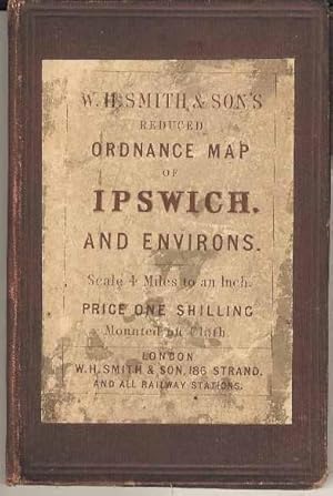
W H Smith and Son's Reduced ordnance Map of Ipswich and Environs
Published by W H Smith and Son, London
Seller: Joy Norfolk, Deez Books, IPSWICH, United Kingdom
Seller rating 5 out of 5 stars
Map
Hardcover. Condition: Good. Dust Jacket Condition: No Jacket (as published). A hard covered 4 miles to an inch folded map showing most of Suffolk and North Essex. On cloth. No dated, but the state of railway building and dual-spelling of Aldeburgh / Aldborough would probably put it at around 1870. Some signs of handling externally but otherwise clean and sound. Available for prompt dispatch from the UK. please email with your queries.
-

W H Smith and Sons Reduced Ordnance Map of North Wales
Published by W H Smith N.D., London
Seller: Castle Hill Books, Llandrindod Wells, United Kingdom
Seller rating 4 out of 5 stars

Hardcover. Condition: Very Good. 18 fold linen backed coloured map of South East Wales, 4 miles to an inch, bound into red cloth covers with paper title label on front, cost a shilling, not dated ; 16mo.
-
W H Smith and Sons Series of Reduced Ordnance Survey Maps for Tourists: Map of Environs of Buxton and Matlock: Scale 2 Miles to 1 Inch
Published by W H Smith & Son, London
Seller: Silver Trees Books, Malvern, WORCS, United Kingdom
Seller rating 5 out of 5 stars
Soft cover. Condition: Good. No Jacket. J Bartholomew (illustrator). A folding map in card backed red cloth covers; map title in red on black label to front: priced at one shilling. The map is linen backed and is in very good condition with one tiny intersection pinholes and small tear along a fold line; map coloured light green; white sheet inside front cover advertising W H Smith's Travelling Maps as is one to rear; no date but map evidence indicates a date c. 1905.
-

W H Smith & Son's Reduced Ordnance Survey Map of North Devon. Scale 4 miles to an Inch
Published by W H Smith & Sons
Map
Map. Condition: Fair. Folded map mounted on cloth, front of map has been covered with self-adhesive clear plastic; cloth on rear is foxed and stained, some stains show through but not too obtrusively; cloth covered card cover is rubbed and worn, quite marked, and is partially covered with the adhesive plastic. Map covers a district of 72x50 miles, SW corner at Peverell's Cross/st Bellarmins Tor, NW corner Lundy, NE corner just inland from Berrow, SE corner Rousdon (between Axmouth and Lyme Regis), and just north of Torquay. Undated, but late C19?.
-
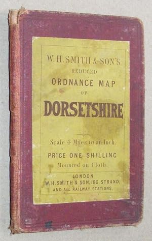
W H Smith & Son's Reduced Ordnance Survey Map of Dorsetshire. Scale 4 miles to an Inch
Published by W H Smith & Sons
Map
Map. Condition: Fair. ` (illustrator). Folded map mounted on cloth, some wear where folds cross, cloth on rear is foxed and stained; cloth covered card cover is rubbed and worn, and quite marked. Map covers a district of 72x50 miles, SW corner takes in Colyton and the River Axe, NW Otterhampton and Axbridge, NE Hurstbourne Tarrant and Andover, SE the New Forest and half of the Isle of Wight. Undated, but late C19?.
-
W H Smith & Sons Reduced Ordnance Map of Carlisle and Environs. Scale 4 miles to an inch. Mounted on Cloth.
Published by London: W H Smith & Son No date
Multifolding linen backed coloured map. Original red cloth with printed paper label to front board. 15 cm x 10 cm. Rubbing and minor marks to cloth.
-

W H Smith and Son's Reduced Ordnance Map of Lincoln and Environs
Published by W H Smith, London
Seller: Roger Lucas Booksellers, Horncastle, United Kingdom
Seller rating 5 out of 5 stars
Condition: Very Good. Scale 4 miles to an inch, 16mo (folded), not dated but circa 1870-1880, linen-backed, 19" x 14", coloured map glued inside drab reddish-brown boards with Smith's label to front with, inside, their list of the maps in the series; good survivor; VG Copy Size: 16mo - over 5�" - 6�" tall.
-
W H Smith & Son's reduced Ordnance map of Salisbury and environs. Scale 4 miles to an inch.
Published by London, London, W, H. Smith & Son, [c.1900.], 1900
Map by J. Bartholomew 47 x 38.5cm, linen mounted and inserted into a cloth case with W.H. Smith's label on the outside and price list and index sheet pasted inside. Coloured in outline. Covering roughly the area Corsham - Reading - Havant - Lulworth plus the Isle of Wight. A very goods copy.
-
W H SMITH & SON'S REDUCED ORDNANCE MAP OF HERTFORD AND ENVIRONS.
Published by W H Smith, London, 1890
Seller: Andrew Johnson Books, Shipston-on-Stour, United Kingdom
Seller rating 5 out of 5 stars
Map
Hardcover. Condition: Good. cloth-mounted coloured map, by J Bartholomew, measuring 49 x 36 cms when open, folding into a hardback cloth cover (10 x 16 cms); covers damp-stained, but not affecting the map, spine faded, title label on front is darkened and rubbed, with an ink name at the top, otherwise outwardly gook; internally the paste-down list of maps, in yellow, is rather split at the spine, and the yellow index map has a name and address in more recent ink, obscuring the lettering at the top; the map itself has a few minor stains on the underside, and a hint of wear to the edge of one fold, but is otherwise very good. Scale 4 miles to an inch. Undated, but c. 1880-1890.
-
W.H. Smith & Son's Reduced Ordnance Map of Lincoln and environs. Scale 4 Miles to an Inch.
Published by W.H. Smith & Son, [ca. 1880]., 1880
Hardcover. Condition: Very Good. 19" by 14" linen-backed coloured map folded in dull red cloth boards with yellow paper label. In very nice state.
-

W H Smith and Son's Reduced Ordnance Map of Norwich And Environs
Published by W H SMITH & SON, London
Seller: Hereward Books, Ely, CAMBR, United Kingdom
Association Member: PBFA
Seller rating 5 out of 5 stars
Hardcover. Condition: Very Good. No date circa 1890 Folding coloured map scale of 4 miles to the inch on cloth measuring (approx. 47.5 x 36.5 cms). Printed map of England on yellow paper pasted to upper fold showing towns. To front paste down list of Smiths Ordnance maps,Some chipping to paper on inner hinge. Folding into plum red cloth case, yellow printed paper label to upper board.Even fading to spine.
-

W H Smith and Son's Reduced Ordnance Map of Lincoln And Envions
Published by W H SMITH & SON, London
Seller: Hereward Books, Ely, CAMBR, United Kingdom
Association Member: PBFA
Seller rating 5 out of 5 stars
Hardcover. Condition: Very Good. No date circa 1890 Folding coloured map scale of 4 miles to the inch on cloth measuring (approx. 49 x 38 cms). Printed map of England on yellow paper pasted to upper fold showing towns. To front paste down list of Smiths Ordnance maps 3 plain paper sheets to front. Folding into plum red cloth case, yellow printed paper label to upper board some even fading to spine.
-

W H Smith and Son's Reduced Ordnance Map of Kent
Published by W H SMITH & SON, London
Seller: Hereward Books, Ely, CAMBR, United Kingdom
Association Member: PBFA
Seller rating 5 out of 5 stars
Hardcover. Condition: Very Good. No date circa 1890 Folding coloured map scale of 4 miles to the inch on cloth measuring (approx. 47.5 x 36.5 cms). Printed map of England on yellow paper pasted to upper fold showing towns. To front paste down list of Smiths Ordnance maps 3 plain paper sheets to front , hand written note on 1 sheet relating to Faversham.Some chipping to paper on inner hinge. Folding into plum red cloth case, yellow printed paper label to upper board some even fading to spine.
-

W H Smith and Son's Reduced Ordnance Map of Somerset
Published by W H SMITH & SON, London
Seller: Hereward Books, Ely, CAMBR, United Kingdom
Association Member: PBFA
Seller rating 5 out of 5 stars
Hardcover. Condition: Very Good. No date circa 1890 Folding coloured map scale of 4 miles to the inch on cloth measuring (approx. 47.5 x 36 cms). Printed map of England on yellow paper pasted to upper fold showing towns. To front paste down list of Smiths Ordnance maps. Some chipping to paper on inner hinge. Folding into plum red cloth case, yellow printed paper label to upper board some even fading to spine.
-

W H Smith and Son's Reduced Ordnance Map of Dorset And Environs
Published by W H SMITH & SON, London
Seller: Hereward Books, Ely, CAMBR, United Kingdom
Association Member: PBFA
Seller rating 5 out of 5 stars
Hardcover. Condition: Very Good. No date circa 1890 Folding coloured map scale of 4 miles to the inch on cloth measuring (approx. 47.5 x 36 cms). Printed map of England on yellow paper pasted to upper fold showing towns. To front paste down list of Smiths Ordnance maps t.Some slight chipping to paper on inner hinge. Folding into plum red cloth case, yellow printed paper label to upper board.
-

W H Smith and Son's Reduced Ordnance Map of Peterborough And Environs
Published by W H SMITH & SON, London
Seller: Hereward Books, Ely, CAMBR, United Kingdom
Association Member: PBFA
Seller rating 5 out of 5 stars
Hardcover. Condition: Very Good. No date circa 1890 Folding coloured map scale of 4 miles to the inch on cloth measuring (approx. 47.5 x 36.5 cms). Printed map of England on yellow paper pasted to upper fold showing towns. To front paste down list of Smiths Ordnance maps 3 plain paper sheets to front.Some chipping to paper on inner hinge. Folding into plum red cloth case, yellow printed paper label to upper board some even fading to spine.
-

W H Smith and Son's Reduced Ordnance Map of Oxford
Published by W H SMITH & SON, London
Seller: Hereward Books, Ely, CAMBR, United Kingdom
Association Member: PBFA
Seller rating 5 out of 5 stars
Hardcover. Condition: Very Good. No date circa 1890 Folding coloured map scale of 4 miles to the inch on cloth measuring (approx. 47.5 x 36 cms). Printed map of England on yellow paper pasted to upper fold showing towns. To front paste down list of Smiths Ordnance maps 3 plain paper sheets to front.Some chipping to paper on inner hinge. Folding into plum red cloth case, yellow printed paper label to upper board some even fading to spine.
-

W H SMITH & SON'S REDUCED ORDNANCE MAP OF GLOUCESTER, CHELTENHAM AND ENVIRONS
Published by W H SMITH & SON, lond
Seller: Hereward Books, Ely, CAMBR, United Kingdom
Association Member: PBFA
Seller rating 5 out of 5 stars
Hardcover. Condition: Very Good. No date circa 1890 Folding coloured map scale of 4 miles to the inch on cloth measuring (approx. 47.5 x 36.5 cms). Printed map of England on yellow paper pasted to upper fold showing towns. To front paste down list of Smiths Ordnance maps, neat pen ticks beside some.Lacks the 2 plain papers to front as often. Folding into plum red cloth case, yellow printed paper label to upper board.
-
ENVIRONS OF LONDON. Cover title: W.H. SMITH AND SON'S REDUCED ORDNANCE SURVEY MAP OF LONDON AND ENVIRONS. Scale 4 Miles to an Inch.
Published by W H. Smith and Son, 186, Strand and all Railway Stations. No date but c.1872, London, 1872
Seller: Marrins Bookshop, Folkestone, KENT, United Kingdom
Association Member: ABA ILAB PBFA
Seller rating 4 out of 5 stars
Condition: Hyde 156. Colour-printed folding map, 19 x 15 inches, showing from Aston Abbots to East Donyland and from Hindhead to Shadoxhurst. Preserved within original red cloth-covered boards with yellow, printed paper title label to upper board, advertisements to front pastedown and map end fold. Some staining otherwise a very good example. TOPOGRAPHY LONDON FOLDING MAPS TOPOGRAPHY LONDON 19TH CENTURY TOPOGRAPHY.
-
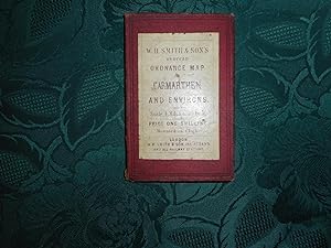
W H Smith & Son's Reduced Ordnance Map of Carmarthen and Environs. Scale 4 Miles to an Inch
Published by W. H. Smith and Son, London, 1900
Seller: Sue Lloyd-Davies Books, CARMARTHEN, United Kingdom
Seller rating 4 out of 5 stars
Hardcover. Condition: Very Good. Dust Jacket Condition: No Dust Jacket. Unknown. NO DATE, circa 1900/10 ? . Scale 4 miles to an inch. Original price One Shilling. In hardback book form with the map inside mounted on cloth. Inner paper hinges split/splitting. A large colour map of Pembroke, Carmarthen, Cardigan. Foxing spots over all and age browning to folds giving it a slightly grubby appearance. Opens up to approx 38 cm x 48 cm. (15" x 19"). NO INSCRIPTIONS. Red cloth covered boards, cream, maroon printed title label tipped on to front board, corners and head/tail of spine bumped and split, slightly grubby. "These splendid maps, unquestionably the most perfect ever published, have been compiled from the Ordnance and Admiralty Surveys, with Railways up to the latest date. There particulars are most minute and accurate, every possible information that a map can give is afforded." (Liverpool Albion) . Scarce See Images ; 24mo 5" - 6" tall.
-

W H Smith and Son's Reduced Ordnance Map of Lancashire
Published by W H SMITH & SON, London
Seller: Hereward Books, Ely, CAMBR, United Kingdom
Association Member: PBFA
Seller rating 5 out of 5 stars
Hardcover. Condition: Very Good. No date circa 1890 Folding coloured map on cloth scale of 4 miles to the inch. Measuring (approx. 44.5 x 38 cms). Printed map of England on yellow paper pasted to upper fold showing towns. To front paste down list of Smiths Ordnance map, e 2 plain pages for notes to front. Folding into plum red cloth case, yellow printed paper label to upper board.Unusual to retain the plain paper pages.
-
W.H. Smith & Son's Reduced Ordnance Map of London and Environs; "Geographia" Vest Pocket Street Plan of Central London [2 maps]
Published by Published by W.H. Smith & Son; Geographia 1872; 1920s, London, 1872
Seller: Keoghs Books, Skipton, United Kingdom
Association Member: PBFA
Seller rating 5 out of 5 stars
Map
, linen backed colour map of area around London 38 x 49 cm folding into cloth covered wallet with adverts; coloured paper folding map 51 x 76 cm of central London streets Early editions , corners and spine rubbed, marks to boards of W H Smith map, foxing to linen backing, cover taped to front of Geographia map, small tears to some folds, good condition , 15 cm x 9 cm (folded) Maps ISBN:
-
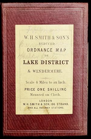
W. H. SMITH & SON'S REDUCED ORDNANCE MAP OF LAKE DISTRICT & WINDERMERE
Published by W. H. Smith & Son, 1880
Seller: BLACK SWAN BOOKS, INC., ABAA, ILAB, Richmond, VA, U.S.A.
Association Member: ABAA ESA ILAB
Seller rating 5 out of 5 stars
Folded map in cloth case, with pastedown. Pastedowns inside with advertisements of Smith's tourist maps & plans of England and of London as well. Colored dissected map, mounted on linen. Minor foxing. 14 1/4" x 18 3/4". Undated, but previous owner name is dated in 1887.


![Seller image for W.H. Smith & Son's Reduced Ordnance Map of London and Environs; "Geographia" Vest Pocket Street Plan of Central London [2 maps] for sale by Keoghs Books](https://pictures.abebooks.com/inventory/md/md30707306357.jpg)