
Order Total (1 Item Items):
Shipping Destination:

United States North America Central by Swanston George (4 results)
Feedback
Skip to main search results
Search filters
Product Type
- All Product Types
- Books (2)
- Magazines & Periodicals (No further results match this refinement)
- Comics (No further results match this refinement)
- Sheet Music (No further results match this refinement)
- Art, Prints & Posters (No further results match this refinement)
- Photographs (No further results match this refinement)
- Maps (2)
- Manuscripts & Paper Collectibles (No further results match this refinement)
Condition
- All Conditions
- New (No further results match this refinement)
- Used (4)
Binding
- All Bindings
- Hardcover (No further results match this refinement)
- Softcover (No further results match this refinement)
Collectible Attributes
- First Edition (No further results match this refinement)
- Signed (No further results match this refinement)
- Dust Jacket (No further results match this refinement)
- Seller-Supplied Images (4)
- Not Print on Demand (4)
Free Shipping
- Free Shipping to U.S.A. (No further results match this refinement)
Seller Rating
-
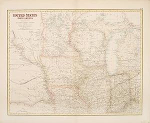
United States. North America - The North Central Section comprising Michigan, Illinois, Wisconsin, Iowa, Indiana, Nebraska, Minnisota [sic] and part of Missouri & Kentucky
Publication Date: 1860
Map
Condition: Good. United States Midwest. Minnisota [sic] territory. Minnesota. SWANSTON 1860 map. Antique atlas map with original hand colour; G H Swanston (1860). 43.5 x 53.5cm, 17 x 21 inches; this is a folding map. Condition: Good. There is nothing printed on the reverse side, which is plain.
-
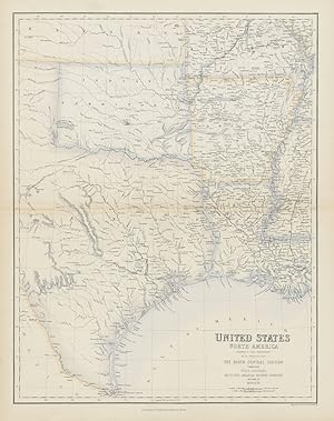
United States. North America - The South Central Section comprising Texas, Louisiana, Mississippi, Arkansas, Western Territory and part of Missouri
Publication Date: 1860
Map
Condition: Good. United States South Central. Texas Louisiana Arkansas. Dallas. SWANSTON 1860 map. Antique atlas map with original hand colour; G H Swanston (1860). 55.0 x 43.5cm, 21.5 x 17 inches; this is a folding map. Condition: Good. There is nothing printed on the reverse side, which is plain. Dallas is marked on the map; it had been incorporated as a city four years before publication of the map in 1856.
-
United States North America, The North Central Section Comprising Michigan, Illinois, Wisconsin, Iowa, Indiana, Nebraska, Minnisota and part of Missouri and Kentucky.
Published by Edinburgh, London & Dublin. 1860, 1860
Seller: Peter Harrington. ABA/ ILAB., London, United Kingdom
Association Member: ABA ILAB PBFA
Seller rating 5 out of 5 stars

A detailed map of the United States from Nebraska in the west to Lake Huron in the east and Missouri in the south to Lake Superior in the north. Gazetteer of the World. A Fullarton & Co. Lithograph. Later colour. In fine condition but with previous restoration to small hole near centre fold Size: 51.6 x 40 cm. (20� x 15� inches).
-

United States North America, The North Central Section Comprising Michigan, Illinois, Wisconsin, Iowa, Indiana, Nebraska, Minnisota and part of Missouri and Kentucky.
Published by Gazetteer of the World. A Fullarton & Co. 1860, 1860
Seller: Peter Harrington. ABA/ ILAB., London, United Kingdom
Association Member: ABA ILAB PBFA
Seller rating 5 out of 5 stars
A detailed map of the states of the Mid West of the United States. Gazetteer of the World. A Fullarton & Co. Original lithograph. Later colouring. In fine condition but with previous restoration to small hole near centre fold Size: 51.6 x 40 cm. (20� x 15� inches).
![Seller image for United States. North America - The North Central Section comprising Michigan, Illinois, Wisconsin, Iowa, Indiana, Nebraska, Minnisota [sic] and part of Missouri & Kentucky for sale by Antiqua Print Gallery](https://pictures.abebooks.com/inventory/md/md31102178631.jpg)