


THE OFFICIAL STATE ATLAS OF KANSAS: Compiled from Government Surveys, County Records and Personal Investigations.
Everts, L. H.
Published by L. H. Everts & Co., Philadelphia, 1887
Used
hardcover
From
Waugh Books, Lawrence, KS, U.S.A.
Seller rating 5 out of 5 stars
![]()
AbeBooks Seller since April 17, 2008
Association Member:
This specific copy is no longer available. Here are our closest matches for THE OFFICIAL STATE ATLAS OF KANSAS: Compiled from Government Surveys, County Records and Personal Investigations. by Everts, L. H..
About this Item
Description:
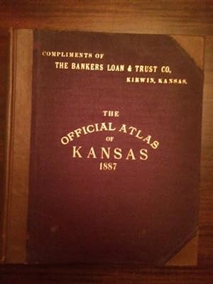
Large folio. [18" X 15"] Spine and corners rebound over original brick red boards. Original gilt titles on front cover. New gilt title on spine. New end papers. 339 numbered pages, including text, plates (with b/w lithographs depicting Kansas ranches, livestock, architecture, and other scenes), and approximately 300 hand colored maps, with 25 colored folding maps. "Compliments of The Bankers Loan & Trust Co., Kirwin, Kansas" stamped in gilt above title on front cover. Rear cover shows wear. Light damp stain to top of title page. Slight edge wear to initial and last pages. A very solid, and handsome copy of the original edition one of the grand state atlases of the 19th century. Due to size and weight, international shipping will require additional postage. Seller Inventory # 1107
Bibliographic Details
Title: THE OFFICIAL STATE ATLAS OF KANSAS: Compiled...
Publisher: L. H. Everts & Co., Philadelphia
Publication Date: 1887
Binding: hardcover
Condition: Very Good
Edition: First edition.
Top Search Results from the AbeBooks Marketplace

The Official State Atlas of Kansas Compiled from Government Surveys County Records and Personal Investigations
Published by
Kansas Council of Genealogical Societies, Wellington, KS, 1982
Used
Hardcover
Seller: Books by White/Walnut Valley Books, Winfield, KS, U.S.A.
Seller rating 5 out of 5 stars
![]()
Hardcover. Condition: Near Fine. No Jacket. Reprint Edition. Kansas Council of Genealogical Societies, Wellington, KS. 1982. Hardcover. Reprint of the 1887 original. Book is tight, square, and unmarked. Book Condition: Near Fine; light bumping to three tips; light shelfwear to head. No DJ. Black cloth boards and spine with antique gold printing on the spine and large gilt Kansas emblem on the front board. Spine states Reproduction by Walsworth. 340 pp of numbered pages (plus many unnumbered pages) of maps. The introductory letter from GOV John Carlin states that is book is a step in preserving Kansas history and the maps and photographs show the state as it once looked to provide a benchmark to measure the history of Kansas. Regarding the original atlas "This massive compilation contains a vast wealth of information on Kansas at the time of publication. Many of the views depict stock ranches, which are also located on the extremely detailed maps. There are many bird's-eye views of towns and sights. Much of the accompanying text is devoted to listing the leading citizens of the state, their property, what kind of livestock they raise, and even what kind of fencing they use". This book continues these features. A clean very presentable copy. No International Shipping. No additional shipping costs for media mail. Priority shipping will require additional postage. Seller Inventory # 015763
Quantity: 1 available
THE OFFICIAL STATE ATLAS OF KANSAS, COMPILED FROM GOVERNMENT SURVEYS; COUNTY RECORDS AND PERSONAL INVESTIGATIONS.
Published by
L. H. Everts & Co., 1887., Philadelphia, 1887
Used
Hardcover
First Edition
Seller: BUCKINGHAM BOOKS, ABAA, ILAB, IOBA, GREENCASTLE, PA, U.S.A.
Seller rating 5 out of 5 stars
![]()
First edition. First edition. Folio. 18" x 15" x 3" Original calf spine and corners and cloth, titles stamped in gold gilt on the front cover, 339 numbered pages (plus many more unnumbered pages of views), preface, illustrated by hundreds of colored maps and plates in black & white. Twenty-five colored folding maps. A large 30.9 cm. x 70,9 cm. [12 1/4" x 28"] folding map.This is the first large atlas for the state of Kansas. Six Score 83 says "These atlases were designed so that pages could be tipped in. I doubt that any two copies are exactly alike." "This massive compilation contains a vast wealth of information on Kansas at the time of publication. Many of the views depict stock ranches, which are also located on the extremely detailed maps. There are many bird's eye views of towns and sights. Much of the accompanying text is devoted to listing the leading citizens of the state, their property, what kind of livestock they raise, and even what kind of fencing they use. The Everts' atlas is an important source for much information, with illustrations existing nowhere else." Rumsey 2818 says "The views show the remarkable development of the state over two decades after the Civil War." Dorothy Sloan states, "This atlas is rich in stock raising iconography and statistics. Many of the maps, which are certified as correct by various officials, locate ranches. Because of their large scale, the maps are quite detailed and show railroads, waterways, churches, cemeteries, and various features in the towns depicted. Numerous manufacturing establishments are also shown. The lithographed scenes, which were probably paid for by the owners of the properties depicted, show numerous prosperous farms, ranches, and town residences in their rural Victorian splendor. The detailed town maps are important documentation of a time when many of them were in their infancy. The importance of railroads in town development is obvious. The large folding map at the front was the best available map of Kansas at that time." Several pages in the "content" section of pages have small chips (repaired) with minor loss of lettering, also a few minor fore-edge repairs to the margin of a few pages at the rear of the volume, and some light cosmetic restoration to the front and rear leather corners of the covers, the maps and plates are in fine, bright condition, else a very good, tight copy of a beautiful cartographic production. The coloring is bright and this is a tough book to find in even good condition because of its size and weight. Seller Inventory # 42443
Quantity: 1 available