Antique Map-SOUTH WEST ENGLAND-WALES-CORNUBIA-Mercator-c. 1600
Used
From
ThePrintsCollector, Zeeland, Netherlands
Seller rating 5 out of 5 stars
![]()
AbeBooks Seller since April 3, 2017
This book is no longer available. AbeBooks has millions of books. Please enter search terms below to find similar copies.
About this Item
Description:
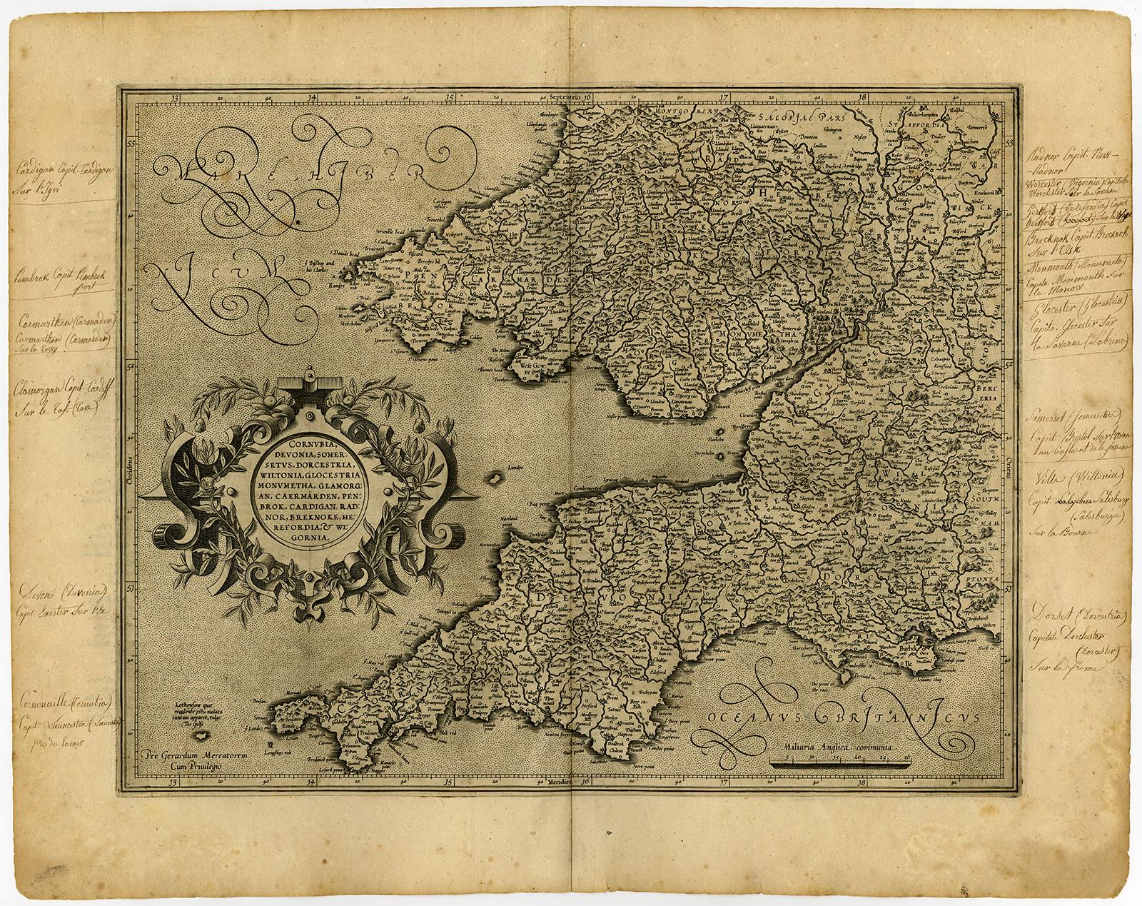
Antique map, titled: 'Cornubia, Devonia, Somersetus, Dorcestria, Wiltonia, Glocestria, Monumetha, Glamorgan, Caemarden, Penbrok, Cardigan, Radnor, Breknoke, Herefordia & Wigornia.' - This very decorative map showns Southwestern England and parts of Wales. Includes the counties of Cornwall, Devon, Sommerset, Dorset, Wilton, Glouchester, Glamorgan, Caermarden, Penbroke, Cardigan, Radnor Breknoke, Hereford and Wigorn. With manuscript old geographic annotations in margins. Etching / engraving on hand laid (verge type) paper. Watermark: Unidentified watermark. "Description: From an undetermined French ed. of a Mercator Atlas: 'Atlas Sive Cosmographia �' Ref: Van der Krogt (Atlantes) 5112:1.1 Artists and Engravers: Made by an anonymous engraver after 'Gerard Mercator'. Gerard Mercator (Kremer) was born in Rupelmonde in Flanders and studied in Louvain. He drawn his first map in 1537 and became a cartographer and globe maker. In 1552 he moved to Duisburg, Germany where he published his famous 18-sheet world map in 1569 with his own new projection, today called Mercator projection. Later he decided to publish a new edition of Ptolemy's Geographia. Followed by his major work, a 3 volume collection of maps to which the word "Atlas" was applied the first time. The first volume was published 1585, followed by the second in 1589 and the third one after his death in 1595 by his son Rumold. A second edition of all three parts was published 1602. 1604 Jodocus Hondius acquired the plates and published several edition together with his sons Jodocus II and Henricus until 1633. More editions followed until 1666 by Janssonius who was in partnership with Henricus. Some of the plated where also used in W.J. Blaeu in 1630." Condition: Very good, given age. Very nice dark impression. Remains of tape from attachment to matting on rear. Overall light foxing. General age-related toning and/or occasional minor defects from handling. Please study scan carefully. Storage location: B17-04 The overall size is ca. 22.8 x 18.1 inch. The image size is ca. 18.5 x 14.6 inch. The overall size is ca. 58 x 46 cm. The image size is ca. 47 x 37 cm. Seller Inventory # 51238
Bibliographic Details
Title: Antique Map-SOUTH WEST ...
AbeBooks offers millions of new, used, rare and out-of-print books, as well as cheap textbooks from thousands of booksellers around the world. Shopping on AbeBooks is easy, safe and 100% secure - search for your book, purchase a copy via our secure checkout and the bookseller ships it straight to you.
Search thousands of booksellers selling millions of new & used books
New & Used Books

New and used copies of new releases, best sellers and award winners. Save money with our huge selection.
Rare & Out of Print Books

From scarce first editions to sought-after signatures, find an array of rare, valuable and highly collectible books.
