


Antique Map WISBECH, CAMBRIDGESHIRE, UK, Street Plan, Dawson Original 1832
Used
From
Lindisfarne Prints, Shrewsbury, SHROP, United Kingdom
Seller rating 5 out of 5 stars
![]()
AbeBooks Seller since August 29, 2017
This book is no longer available. AbeBooks has millions of books. Please enter search terms below to find similar copies.
About this Item
Description:
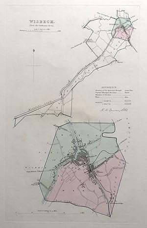
Original Antique MapWISBECHby Robert Kearsley DawsonPublished 1832An original 19th century antique street plan of Wisbech, Cambridgeshire, England. Drawn up by Lieutenant R.K. Dawson of the Royal Engineers and published by the Boundaries Commission in 1832.The whole country was surveyed for the commission to support the 1832 reform bill - a major shake-up of the nation's parliamentary representation.The upper map is on a scale of 1 inch to a mile and the lower at 4 inches to the mile. There is much detail here including individual buildings and it's interesting to compare the 19th century map with the much expanded Wisbech of the present day.Enhanced with original hand colouring and a colour key to the various boundaries.Fine, clean condition, free of repairs or restoration. No folds, blank verso. This large paper format is superior to the numerous folding editions which are so prone to offsetting and wear.Approx. 13.5" x 8.5" (340mm x 210mm) printed area only within the plate mark. (as depicted), with good margins beyond.A GENUINE ORIGINAL ANTIQUE MAP GUARANTEED OVER 180 YEARS OLD FROM LINDISFARNE PRINTSVNFF919. Seller Inventory # 20178
Bibliographic Details
Title: Antique Map WISBECH, CAMBRIDGESHIRE, UK, ...
AbeBooks offers millions of new, used, rare and out-of-print books, as well as cheap textbooks from thousands of booksellers around the world. Shopping on AbeBooks is easy, safe and 100% secure - search for your book, purchase a copy via our secure checkout and the bookseller ships it straight to you.
Search thousands of booksellers selling millions of new & used books
New & Used Books

New and used copies of new releases, best sellers and award winners. Save money with our huge selection.
Rare & Out of Print Books

From scarce first editions to sought-after signatures, find an array of rare, valuable and highly collectible books.
