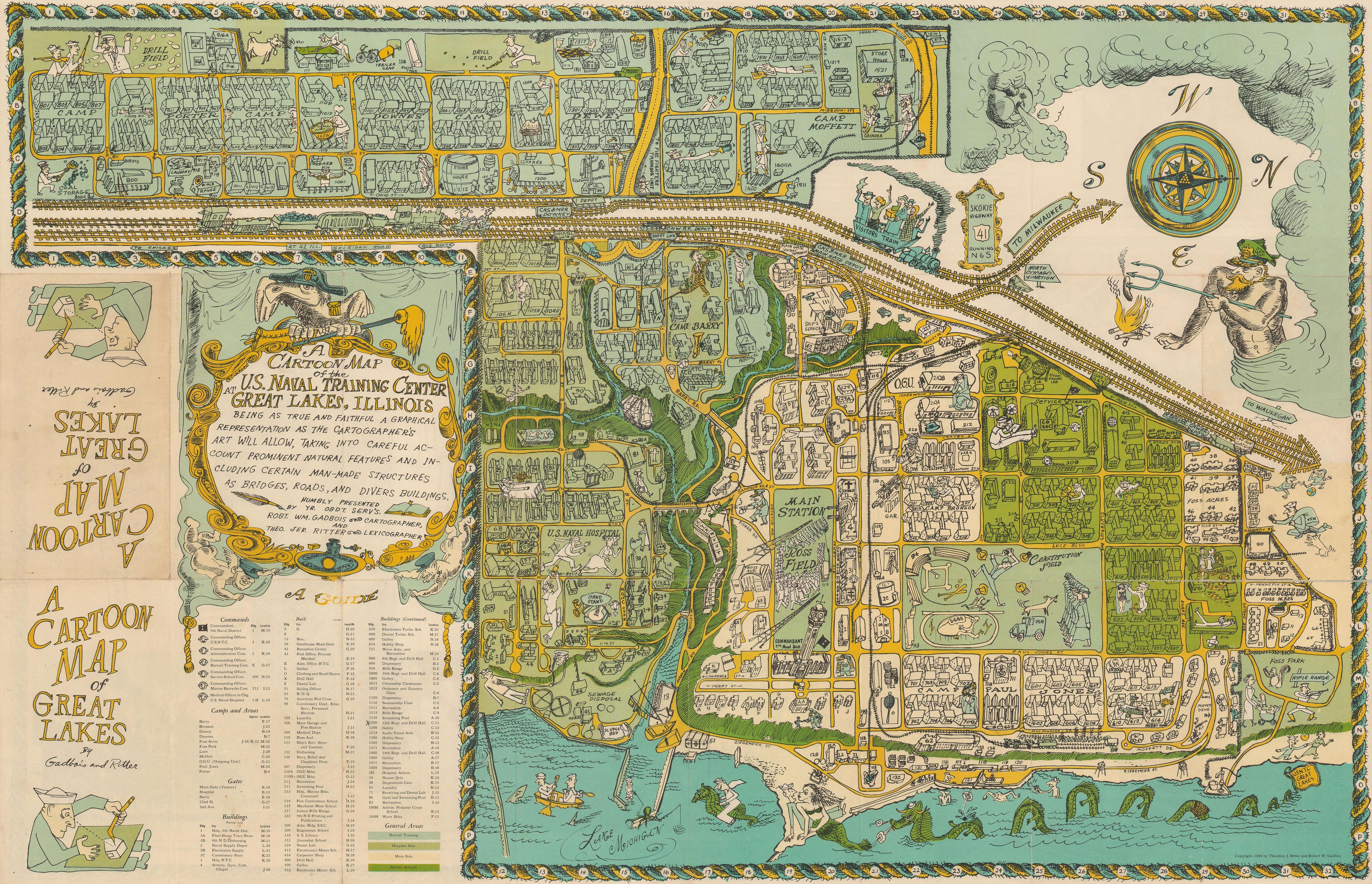
A Cartoon Map of the U.S. Naval Training Center Great Lakes, Illinois, Being as True and Faithful a Graphical Representation as the Cartographer's Art Will Allow, Taking Into Carful Account Prominent Natural Features and Including Certain Man-Made Structures as Bridges, Roads, and Divers Buildings.
- Map
- Used

Seller: Geographicus Rare Antique Maps, Brooklyn, NY, U.S.A.Geographicus Rare Antique Maps
AbeBooks seller since November 21, 2024
Association member: ABAAESAILAB
View this seller's itemsCondition: Used
US$ 840.00
Quantity: 1 available
Add to basketItem description from seller
Good. Wear along original fold lines. Verso repairs to fold separations. Text and printed photographs on verso. Size 22 x 34 Inches. This is a 1949 Robert William Gadbois and Theodore J. Ritter cartoon pictorial map of the U.S. Naval Training Center Great Lakes, situated on the banks of Lake Michigan just north of Chicago in Illinois. Created in the post-war period, the map depicts the training center from the east and illustrates from Camp Porter to Foss Park and from the drill field to Lake Michigan. Highly detailed, myriad buildings throughout the U.S.N.T.C. are illustrated and labeled. Numerous camps, set up to house the tens of thousands of men present at the camp at any one time, are identified (most of which are named after Naval heroes), including Camp Downes, Camp Dewey, Camp Barry, Camp Moffett, and Camp Paul Jones. Ross Field, across from the main railway station, is named after Captain Albert R. Ross who supervised the base's construction. The Naval Hospital is also prominently labeled, complete with a patient drawn chasing a nurse. Other comic illustrations include a man in a striped suit, sailors playing ping pong, and another sailor drilling holes in the Drill Field. Others include a sea monster in Lake Michigan wearing a sailor's 'gob cap', a sailor riding a gigantic sea horse, and another sailor being romanced by a mermaid. There's even an octopus using a fishing pole fishing off a pier! A large decorative cartouche is situated in the lower left quadrant, just above an index of over one hundred buildings located throughout the base. U.S. Naval Training Center Great Lakes Naval Station Great Lakes was founded in 1905 and construction began that year. The base opened its gates on July 1, 1911. Great lakes was then a fairly modest installation, occupying only 165 acres. By the end of World War I, in 1918, the base had grown to 1,200 acres and over 125,000 sailors had passed through on their way to fight. After the war ended, the training of recruits slowed to a crawl, and even halted for a while. The only major operations going on at the base were the air base and the Radio School. By 1940, however, with threats from both oceans, increased enlistments in the Navy were finally approved by Congress. Within ten months of the attack on Pearl Harbor, the base had grown to nearly 1,600 acres. By the end of World War II, four million men were in uniform in the U.S. Navy, and over one million of them had passed through Great Lakes. Within ten months of the attack on Pearl Harbor, the base had grown from 172 acres to nearly 1,600 with seventeen separate camps in operation. By mid-1943, over 700 instructors were working at the base. Great Lakes was also the first naval installation to train African-American troops, although the base wouldn't be integrated until mid-1945. Today, Great Lakes is the largest training facility for the U.S Navy and even houses the elite Naval Special Warfare Preparatory School, where sailors hoping to become Navy SEALs are sent to train. Publication History and Census This map was created by Robert William Gadbois and Theodore J. Ritter and published in 1949. It is quite rare, as we have been able to trace only two examples in institutional collections at the Library of Congress and Stanford University. We have been able to locate only three instances of this piece entering the private market in the last ten years. References: Rumsey 8744.002. OCLC.…
Seller Inventory # USNTCGreatLakes-gadboisritter-1949
Bibliographic details
- Title
- A Cartoon Map of the U.S. Naval Training Center Great Lakes, Illinois, Being as True and Faithful a Graphical Representation as the Cartographer's Art Will Allow, Taking Into Carful Account Prominent Natural Features and Including Certain Man-Made Structures as Bridges, Roads, and Divers Buildings.
- Author
- 948645527
- Publication year
- 1949
- Seller catalogs
- ILLINOIS-MAPS
Geographicus Rare Antique Maps
Brooklyn, NY, U.S.A.
Shipping rates within U.S.A.
| Item | 7 to 14 business days | 2 to 8 business days |
|---|---|---|
| First item | US$ 17.00 | US$ 45.00 |
Payment methods
Store description
Geographicus Rare Antique Maps was founded in New York, New York, by Kevin James Brown in 1999. We are specialist antiquarians dealing in historic maps from all over the world and in all price ranges. Our enthusiasm, passion, and devotion to scholarship is expressed in our meticulously researched descriptions, among the most detailed and comprehensive available anywhere, for each and every rare map that passes over our desk. This same devotion guides the relationships of honesty and trust we have fostered with our clients, whether through purchasing or selling a rare map, getting an appraisal, or simply calling to discuss antique maps in general. We are happy to assist you no matter whether you are an interior decorator, an institution, an experienced collector, or are just looking for a single antique map. Geographicus is a member of the ABAA (Antiquarian Booksellers' Association of America), the ILAB (International League of Antiquarian Booksellers), the New York Map Society, the Washington Map Society, the IMCOS, and the Society for the History of Discoveries. While primarily an internet-based company, we are happy to meet with clients to show our antique maps by appointment at our New York City location.…
Specialty
MAPSAssociation member
Members of these associations are committed to maintaining the highest standards. They vouch for the authenticity of all items offered for sale. They provide expert and detailed descriptions, disclose all significant defects and/or restorations, provide clear and accurate pricing, and operate with fairness and honesty during the purchase experience.Terms of sale
Guarantee
Geographicus Rare Antique Maps offers a full guarantee of authenticity on every map we sell. We do not trade in modern reproductions or contemporary copies. A signed Certificate of Authenticity will accompany every map we sell. Any map legitimately found to be a fake or reproduction may be returned to Geographicus at any time for a full refund. Returns based on claims of inauthenticity must be accompanied by no less than two letters from industry professionals (other ABAA/ILAB dealers, map librarians, map curators, certified appraisers, auctions house specialists, etc.) attesting that the map or book in question is a contemporary forgery or reproduction and explaining their reasoning.
Payment
Geographicus accepts cash, checks (U.S. Dollars only), Visa, Master Card, American Express, Discover, PayPal and bank transfers. Items purchased by check will be held until the funds are verified by our bank - this may take up to one week. Certain transactions paid by major credit cards may also be delayed if our merchant processer's fraud department identifies high levels of risk. We do not accept traveler checks, money orders, or cashier checks.
Customs and Tax
All customs and other international tax charges are the buyer's responsibility and will vary from country to country. For a specific list of customs regulations for other countries please consult that sovereignty's customs office directly.
Shipping terms
Shipping
Geographicus ships Fedex Ground orders Tuesday, and Thursday. Typically orders placed before 3PM EST during these days, will be shipped on the same day. Orders placed after 3PM EST will be shipped on the next shipping day. For domestic shipping, we use FedEx Ground, FedEx Express, and if necessary USPS Express. International shipments are dispatched via DHL or FedEx International, depending on the size of parcel and destination. Other shipping can be arranged on request but may incur additional fees. We do not ship on Saturdays, Sundays, or official U.S. Holidays. All shipments require a signature on delivery. All shipments are insured. Clients will be provided with a tracking number for all shipments. Geographicus does not use freight forwarders or third party shipping agents.
We do our best to ensure timely delivery of your purchases. Nonetheless, even the best courier services do not have perfect track records. Holidays, weekends, international customs, vehicle breakdowns, and inclement weather can result in unforeseen and unavoidable delays. If you are purchasing an item for a gift or you otherwise have a specific deadline, please specify this information on your order form and use a shipping method that allows a safe time cushion for receipt of your order.
Handling, Customs, and Storage
Geographicus does not refund any shipping, handling, storage fees or international customs charges that the buyer may incur after purchasing an item from us. All customs charges are the buyer's responsibility and will vary from country to country. For a specific list of customs regulations for other countries please consult that sovereignty's customs office directly.
Insurance
All maps and books shipped to and from Geographicus Rare Antique Maps are insured by our Fine Arts Dealer policy. The deductible on all shipped items is 100 USD. The deductible is paid by the shipper unless otherwise agreed. Damage claims must be filed within 7 days of receipt to be honored. Lost parcel claims can be filed up to 3 months after the shipment is sent.