

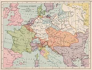
Central Europe 1789
Other cartographers
Publication Date: 1907
Used
From
Antiqua Print Gallery, London, United Kingdom
Seller rating 4 out of 5 stars
![]()
AbeBooks Seller since January 14, 2022
This specific copy is no longer available. Here are our closest matches for Central Europe 1789.
About this Item
Description:
EUROPE IN 1789. Holy Roman Empire. Division of Poland 1907 old antique map. Antique colour map; Unsigned (1907). 14.0 x 18.5cm, 5.5 x 7.25 inches. Condition: Good. There is nothing printed on the reverse side, which is plain. Seller Inventory # P-6-049176
Bibliographic Details
Title: Central Europe 1789
Publication Date: 1907
Condition: Good
Top Search Results from the AbeBooks Marketplace

CENTRAL EUROPE 1789 ,ANTIQUE COLOUR MAP PRINT 1905 HISTORICAL MAP
Published by
Gardiner
Used
Seller: Artisans-lane Maps & Prints, Victoria, BC, Canada
Seller rating 5 out of 5 stars
![]()
no binding. Condition: very good. PUBLISHED DATE 1905, LONDON, NEW YORK,BOMBAY PUBLISHER LONGMAN, GREEN & CO. LTD. PAGE SIZE 8 1/2 x 6 3/4 inches CONDITION FULL PAGE MAP. Blank on back. Suitable ageing. As scanned. The image is clean, clear and sharp with beautiful detail. This beautiful rare item would look great matted and framed. An art supply store can provide you with a selection of frames for old art treasures. NOTE THE FOLLOWING BEFORE YOU PURCHASE: This is a GENUINE ANTIQUE PRINT. It is NOT a modern reproduction, ie. a laser scan, photocopy etc. This print was published on the date mentioned, or circa of the date mentioned at the top of the page. The term "print" is referred to an image on a piece of paper. The print I have for sale, like many antique prints, originate from an antique book publication. The publication may not always be known. If you have any questions, emails are welcome. Seller Inventory # 1388
Quantity: 1 available