About this Item
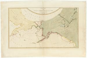
The Legendary lost chart of Captain Cook Rare first edition. This map of Captain James Cook s third and final voyage (1778 1780) was published in London in 1784 and accompanied by many sketches and drawings by his officers. A second edition was published in 1794. On this final voyage, Cook and his men became the first Europeans to visit the Hawaiian Islands, which they named The Sandwich Islands. The expedition then sailed up the northwest coast of North America, up into the Bering straits and the Arctic Ocean, in search of the Northwest passage, before sailing south, returning to Hawaii in 1779. They stayed in Hawaii for a month. Then just as they were to leave, a skirmish took place between the Hawaiians and Cook s men. During this skirmish, Cook was killed. On that journey north, Cook made the first complete charts of the Northwest of America, including Spanish and Russian possessions, he also charted the north Alaskan coast, and northern Siberian coast in the Chukchi Sea or perhaps more properly, these charts were made by Lt. Henry Roberts, the master s mate, under the immediate supervision of Capt. Cook. After Cook s death, the expedition again sailed north under the command of Captain Charles Clerke to the Bering straits, and then south, along the coast of Siberia, charting the journey down the coast of the Kamchatka Peninsula. Following the expedition s return to England in 1780, the much-anticipated journals and charts of the journey fell prey to Cook s political enemies (and perhaps to the political influence of the Hudson Bay Company), with the result that Roberts s chart was not included in the official publications of the journey, but rather was published separately. Because of this history, it has become known as The Legendary Lost Chart of Captain Cook. The chart that Roberts sold to publisher William Faden included Samuel Hearne s c.1772 manuscript map of the Coppermine River in Canada, then in the possession of the Hudson s Bay Company, and which had never before appeared in print. Hearne s exploration of the Coppermine, whose waters eventually run all the way to the Arctic Ocean, proved that there was no Northwest Passage through Hudson s Bay. It is possible that the Hudson s Bay Company wished to suppress this information, thus contributing to the less detailed map that was included in the official publication. Hearne s journal and maps weren t published until full decade after our Roberts/Faden map. Another possible reason that Roberts chart was dismissed from the official account could be a result of the involvement of Alexander Dalrymple in the selection process. Dalrymple may have harbored ill feelings towards Cook for having been chosen, instead of him, to lead the Second Pacific Voyage of 1772-75, an expedition that ultimately disproved the myth of Terra Australis Icognita ( the unknown southern land ) the vast hypothetical landmass based on classical beliefs in symmetry that appeared on maps between the 15th and 18th centuries an idea which of Dalrymple himself advocated. As such, Dalrymple may have wanted to downplay Cook s achievements and discoveries. For two hundred years, the true source of the Faden publication was unknown, until, in 1985, the British Library acquired a proof copy that served to prove its source. Because it was not the official publication, this striking map is much rarer than the official map, while at the same time it contains more information (in addition to the Hearne journey, it contains many place names not included in the official map).
Seller Inventory # NL-00479
Contact seller
Report this item
