About this Item
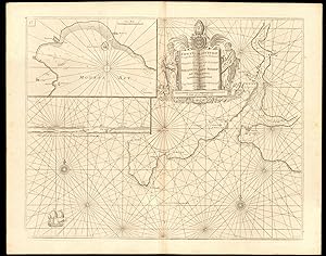
'FOWEY & MOUNTS BAY' sea chart. Polruan Bodinnick Penzance. COLLINS c1774 map. Decorative antique eighteenth century copperplate nautical sea chart, printed on thick paper; Captain Greenvile (or Greenville) Collins. Collins was an officer of the Royal Navy and prominent hydrographer, who was commissioned by King Charles II in 1676 and appointed by Samuel Pepys (then Secretary to the Admiralty), to chart the coasts of Great Britain. The resulting atlas - Great Britain's Coasting Pilot - was the first original sea atlas to be produced by an Englishman. Prior to publication of these maps, nautical charts were often defective, and there was no centralised system for collecting and disseminating the better maps made by experienced seamen. In 1681, Collins gained the king's preferment to survey the country's coasts. The Admiralty supplied Collins with the 8-gun yacht HMSMerlin for the first two years and later the yacht HMSMonmouth until 1686. His work was carried out under the supervision of Trinity House, who also supported the project financially. Samuel Pepys insisted that Collins be made a younger brother of Trinity House. Collins spent seven years on the survey, the first edition of which was published in 1693, as "Great Britain's Coasting Pilot". The charts, while not completely accurate, were an enormous advance on anything before them, entitling Collins to rank as not only one of the earliest, but also among the best of English hydrographers. Twenty-one further editions were published during the eighteenth century. (Published after 1774, possibly in 1792. The atlas within which this map was printed (see provenance) was first published in 1693 with a number of later editions published through the eighteenth century. The publication date stated on the title page of this edition of the atlas is "MDCCLXCII", which is unintelligible and erroneous as it does not conform to standard notation for Roman Numerals. The text within the book from which the map was extracted refers to tidal variations up to the year 1774, hence we state the publication date as after 1774. This edition of the atlas does not appear in the English Short Title Catalogue. The publisher is stated to be "Mount & Davidson", which differs from the publisher of other editions through the early part of the 18th century, which is stated to be "Mount & Page". Mount & Davidson appear to have been active as publishers in the 1780's and early 1790's. A publication date of 1792 (MDCCXCII) would be consistent with stated year of publication if the "L" had been erroneously inserted.). 63.5 x 51.0cm, 25 x 20 inches; this is a folding map. Condition: Good. Please contact us if you would like to arrange to view this map. There is nothing printed on the reverse side, which is plain. The chart depicts the Fowey river estuary. A number of features are shown including the towns/villages of Fowey, Polruan, Bodinnick ("Pendennick") and Menabilly. The smaller chart inset in the top left hand corner depicts Mount's Bay, including Penzance, St Michael's Mount, Mousehole and Market Jew (Marazion). Below the insert chart is a coastal recognition profile for the entrance to the Fowey estuary, with Coombe Farm, Fowey Castle, St Catherine's chapel and St Saviour's church (Polruan) marked.
Seller Inventory # P-8-000399
Contact seller
Report this item

