

Japan
Weller, Edward
Publication Date: 1868
Used
From
Antiqua Print Gallery, London, United Kingdom
Seller rating 4 out of 5 stars
![]()
AbeBooks Seller since January 14, 2022
This specific copy is no longer available. Here are our closest matches for Japan by Weller, Edward.
About this Item
Description:
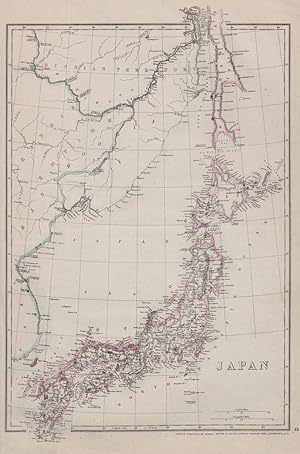
EMPIRE OF JAPAN w/ Sakhalin.River Amur.1858 Russia/China border.WELLER 1868 map. Antique map with original outline colour; Engraved by Edwd. Weller (1868). 46.0 x 31.0cm, 18.25 x 12.25 inches. Condition: Good. The image shown may have been taken from a different example of this map than that which is offered for sale. The map you will receive is in good condition but there may be minor variations in the condition from that shown in the image. This map was coloured by hand at the time of publication, thus the colouration may vary slightly between different examples of the map; the colouring applied to the map you receive may differ slightly from that shown in the image. There is nothing printed on the reverse side, which is plain. The map shows the Island of Sakhalin (Saghalien) divided between Russia and Japan, and Outer Manchuria with the 1858 borders between China and Russia, mid way through the Amur (Amoor) Acquisition. In 1855, Russia and Japan had signed the Treaty of Shimoda, which agreed that nationals of both countries could inhabit Sakhalin: Russians in the north, and Japanese in the south, without a clear boundary between them, as reflected on the map. The southern part of Sakhalin was held by Japan until the 1875 Treaty of Saint Petersburg, when they ceded it to Russia in exchange for the Kuril Islands. The map shows the then "new" border between Russia and China. Following the Opium War, Russia forced China to sign the Treaty of Aigun (1858), as reflected on the map. The effect of the later Convention of Peking (1860) is not reflected on the map. Under this treaty, China ceded to Russia all claims to all territories north of Heilongjiang (Amur River) and east of the Ussuri river, including Vladivostok. Seller Inventory # P-8-002455
Bibliographic Details
Title: Japan
Publication Date: 1868
Condition: Good
Signed: Signed by Author(s)
Top Search Results from the AbeBooks Marketplace

Seller Image
"The Empire of Japan" - Japan China Asia Asien Karte map
Published by
London ca. 1850., 1850
Used
Seller: Antiquariat Steffen V�lkel GmbH, Seubersdorf, Germany
Seller rating 5 out of 5 stars
![]()
OriginalLithographie von ca. 1850. - Blattmasse: ca.48 x34 cm - gut erhalten. || Original lithograph from c. 1850. -- in good condition. | Dies ist ein Original! - Kein Nachdruck! - Keine Kopie! -- This is an original! No copy! - No reprint!- No reprint! Sprache: Englisch Gewicht in Gramm: 1550. Seller Inventory # 214226
Quantity: 1 available
Seller Image
Japan
Used
Seller: Antiqua Print Gallery, London, United Kingdom
Seller rating 4 out of 5 stars
![]()
Condition: Good. Japan by Edward Weller 1860 old antique vintage map plan chart. Antique engraved atlas map with original hand colour/color; Edward Weller (1860). 36.0 x 27.0cm, 14.25 x 10.75 inches. Condition: Good. The right margin has been reconstructed. There is nothing printed on the reverse side, which is plain. Seller Inventory # P-7-026879
Quantity: 1 available
Seller Image
Japan
Used
Seller: Antiqua Print Gallery, London, United Kingdom
Seller rating 4 out of 5 stars
![]()
Condition: Fair. Japan by Edward Weller 1860 old antique vintage map plan chart. Antique engraved atlas map with original hand colour/color; Edward Weller (1860). 36.0 x 27.0cm, 14.25 x 10.75 inches. Condition: Fair: Spotting; The right margin has been reconstructed. Minor offsetting -text and/or images from the facing page have left an impression on the print. There is nothing printed on the reverse side, which is plain. Seller Inventory # P-7-026787
Quantity: 1 available
Seller Image
Japan.
Published by
Blackie & Son, [c1860]., Glasgow, Edinburgh & London,, 1860
Used
Seller: Daniel Crouch Rare Books Ltd, London, United Kingdom
Seller rating 4 out of 5 stars
![]()
A map of Japan from the 'Imperial Atlas' Engraved map printed in colours, inset of Yeddo Bay (Tokyo). A map of Japan, from the 'Imperial Atlas'. A table below the scale bar provides the English translation of Japanese geographical terms. Blackie and Son was a publishing house based in Glasgow and London from 1890 to 1991. The 'Imperial Atlas' was a political atlas published in multiple editions. Edward Weller (1819-1884) was a British engraver and cartographer, and pioneered the production of lithographed maps. State 3 inset of Yeddo Bay added, and reference of divisions above title. Seller Inventory # 15838
Quantity: 1 available
Seller Image
The Empire of Japan with part of the Continent of Asia showing the River Amoor and the new boundary between the Russian & Chinese Territories, by Edward Weller F.R.G.S.
Published by
Engraved by Edwd. Weller, Duke Street, Bloomsbury, [c1858]., London,, 1858
Used
Seller: Daniel Crouch Rare Books Ltd, London, United Kingdom
Seller rating 4 out of 5 stars
![]()
The Empire of Japan with part of the Continent of Asia Chromolithograph map. A map of Japan by Edward Weller, from the 'Weekly Dispatch Atlas', an atlas published in monthly instalments from 1855 for subscribers to John Cassell's newspaper 'The Weekly Dispatch'. Edward Weller (1819-1884) was a British engraver and cartographer, and pioneered the production of lithographed maps. Seller Inventory # 15807
Quantity: 1 available
Seller Image
Japan.
Published by
Blackie & Son, [c1860]., Glasgow, Edinburgh & London,, 1860
Used
Seller: Daniel Crouch Rare Books Ltd, London, United Kingdom
Seller rating 4 out of 5 stars
![]()
A map of Japan from the 'Imperial Atlas' Engraved map printed in colours, inset of Yeddo Bay (Tokyo). A map of Japan, from the 'Imperial Atlas'. A table below the scale bar provides the English translation of Japanese geographical terms. Blackie and Son was a publishing house based in Glasgow and London from 1890 to 1991. The 'Imperial Atlas' was a political atlas published in multiple editions. Edward Weller (1819-1884) was a British engraver and cartographer, and pioneered the production of lithographed maps. State 3 inset of Yeddo Bay added, and reference of divisions above title. Seller Inventory # 15829
Quantity: 1 available
Seller Image
The Empire of Japan with part of the Continent of Asia. showing the River Amoor and the new boundary between the Russian & Chinese Territories, by Edward Weller F.R.G.S.
Published by
London,, 1858
Used
Seller: Daniel Crouch Rare Books Ltd, London, United Kingdom
Seller rating 4 out of 5 stars
![]()
A map of Japan by Edward Weller from the 'Weekly Dispatch Atlas' Chromolithograph map, green stamp. A map of Japan by Edward Weller, from the 'Weekly Dispatch Atlas', an atlas published in monthly instalments from 1855 for subscribers to John Cassell's newspaper 'The Weekly Dispatch'. Edward Weller (1819-1884) was a British engraver and cartographer, and pioneered the production of lithographed maps. Seller Inventory # 15822
Quantity: 1 available
Seller Image
The Chinese Empire. And Japan.
Published by
Glasgow Edinburgh & LondonBlackie & Son c., 1882
Used
Seller: Robert Frew Ltd. ABA ILAB, London, United Kingdom
Seller rating 4 out of 5 stars
![]()
Original colour-printed map (34.5 x 50 cm) of China and Japan. Showing major towns and cities, rivers, mountain ranges and borders. Centrefold crease as issued. Generally an excellent copy. Seller Inventory # 62052
Quantity: 1 available