
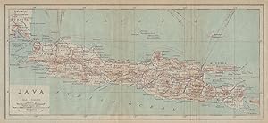
Java
Japanese Government Railways
Publication Date: 1917
Used
From
Antiqua Print Gallery, London, United Kingdom
Seller rating 4 out of 5 stars
![]()
AbeBooks Seller since January 14, 2022
This specific copy is no longer available. Here are our closest matches for Java by Japanese Government Railways.
About this Item
Description:
The island of Java. Dutch East Indies. Indonesia 1917 old antique map chart. Antique colour map; Imperial Japanese Government Railways (1917). 15.0 x 32.5cm, 5.75 x 12.75 inches; this is a folding map. Condition: Good. The image shown may have been taken from a different example of this map than that which is offered for sale. The map you will receive is in good condition but there may be minor variations in the condition from that shown in the image. There is nothing printed on the reverse side, which is plain. Seller Inventory # P-6-105703
Bibliographic Details
Title: Java
Publication Date: 1917
Condition: Good
Top Search Results from the AbeBooks Marketplace

Java
Used
Seller: Antiqua Print Gallery, London, United Kingdom
Seller rating 4 out of 5 stars
![]()
Seller Inventory # P-6-018295
Buy Used
US$ 62.56
US$ 13.50 shipping
Ships from United Kingdom to U.S.A.
Ships from United Kingdom to U.S.A.
Quantity: 1 available