


A Map of the most Inhabited part of New England containing the Provinces of Massachusets Bay and New Hampshire, with the Colonies of Conecticut and Rhode Island, Divided into Counties and Townships: The whole composed from Actual Surveys and its Situation adjusted by Astronomical Observations
[MEAD, Braddock, alias John GREEN (c.1688-1757)]
Published by Thomas Jefferys, London, 1764
Used
From
Donald A. Heald Rare Books (ABAA), New York, NY, U.S.A.
Seller rating 5 out of 5 stars
![]()
Heritage Bookseller
AbeBooks member since 1996
This specific copy is no longer available. Here are our closest matches for A Map of the most Inhabited part of New England containing the Provinces of Massachusets Bay and New Hampshire, with the Colonies of Conecticut and Rhode Island, Divided into Counties and Townships: The whole composed from Actual Surveys and its Situation adjusted by Astronomical Observations by [MEAD, Braddock, alias John GREEN (c.1688-1757)].
About this Item
Description:
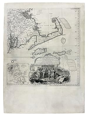
Copper-engraved map, on four unjoined and untrimmed sheets as issued. The largest and most detailed map of New England that had yet been published, and one of the great maps of the east coast of America, by one of the greatest figures in 18th-century cartography: 'Mead's contributions to cartography stand out . At a time when the quality and the ethics of map production were at a low ebb in England, he vigorously urged and practiced the highest standards' (Cumming, p.47). This is the grandest, most accurate and detailed map of New England produced during the British colonial period. It depicts the entire region from Long Island Sound up north to line of 44'30 of latitude. While it shows that the coastal areas, and the lower Connecticut Valley were well settled, areas of the interior, especially in New Hampshire and the future Vermont were just developing, with the early boundaries of townships having recently been established by surveyors. Importantly, this map contains two highly-detailed cartographic insets, one of the city of Boston (upper-left), and another of Boston Harbor on the lower-right sheet. The map is also adorned with a very handsome pictorial title cartouche, depicting the arrival of the Pilgrims at Plymouth Rock in 1620. The present map is the first issue of the second edition of this work, and has been significantly updated from the original issue of 1755. The map's publisher, Thomas Jefferys was the leading British mapmaker of the mid-eighteenth century. He became geographer to the Prince of Wales in 1746 and then to King George III in 1760. He published a remarkable number of maps and charts, and is best known for his work The American Atlas (1775) This map's maker, John Green, was an intriguing and larger-than-life figure, who has been called "the genius behind Jefferys." In addition to his extensive cartographic abilities, Green's personal history also stands out from amongst the biographies of other 18th-century British map makers. Green was born Braddock Mead in Ireland around 1688, married in Dublin in 1715 and moved to London in 1717. He was imprisoned in 1728 for trying to defraud an Irish heiress, and assumed his alias after his release from prison. He worked with Ephriam Chambers on his Universal Dictionary before joining the employ of Cave, Astley, and Jefferys. William Cumming remarked that he 'had a number of marked characteristics as a cartographer . One was his ability to collect, to analyze the value of, and to use a wide variety of sources; these he acknowledged scrupulously on the maps he designed and even more fully in accompanying remarks. Another outstanding characteristic was his intelligent compilation and careful evaluation of reports on latitudes and longitudes used in the construction of his maps, which he also entered in tables on the face of the maps . Mead's contributions to cartography stand out . At a time when the quality and the ethics of map production were at a low ebb in England, he vigorously urged and practiced the highest standards; in the making of maps and navigational charts he was in advance of his time. For this he deserves due credit.' (Cumming, p.45) Degrees of Latitude, 35; McCorkle, New England in Early Printed Maps, 755.19 (first edition/state); Sellers & Van Ee, Maps & Charts of North America & West Indies, 799; Stevens & Tree, "Comparative Cartography," 33(c), in Tooley, The Mapping of America. Cf. Crone, "John Green. Notes on a neglected Eighteenth Century Geographer and Cartographer," Imago Mundi, VI (1950) p. 89-91; Crone, "Further Notes on Braddock Mead, alias John Green" Imago Mundi, VIII (1951) p. 69; Cumming, British Maps of Colonial America, pp.45-47. Seller Inventory # 19736
Bibliographic Details
Title: A Map of the most Inhabited part of New ...
Publisher: Thomas Jefferys, London
Publication Date: 1764
Edition: 1st Edition
Top Search Results from the AbeBooks Marketplace
A Map of the most Inhabited part of New England containing the Provinces of Massachusets Bay and New Hampshire, with the Colonies of Conecticut and Rhode Island, Divided into Counties and Townships: The whole composed from Actual Surveys and its Situation adjusted by Astronomical Observations
Published by
Chez Le Rouge rue des grands Augustins, Paris, 1777
Used
Seller: Donald A. Heald Rare Books (ABAA), New York, NY, U.S.A.
Seller rating 5 out of 5 stars
![]()
Copper-engraved map, on four joined sheets, with original outline colour, in excellent condition. A very fine copy of this highly important and large scale map of New England, the finest map of the region available to military commanders during the Revolutionary War. This is the grandest, most accurate and detailed map of New England produced during the British colonial period. It depicts the entire region from Long Island Sound up north to the line of 44'30 of latitude. While it shows that the coastal areas and the lower Connecticutt Valley were well settled, areas of the interior, especially in New Hampshire and the future Vermont were just developing, with the early boundaries of townships having recently been established by surveyors. Importantly, this map contains two detailed cartographic insets, one of the city of Boston (upper-left), and another of Boston Harbor on the lower-right sheet. The map is also adorned with a very handsome pictorial title cartouche, depicting the arrival of the Pilgrims at Plymouth Rock in 1620. The present map is the edition produced by Georges-Louis Le Rouge, then the royal Geographer to Louis XVI, and was significantly updated from the original issue of 1755. Copies of this issue would most certainly have been consulted by French commanders such as the Comtes D'Estaing and Rochambeau who both led forces in New England following France's entry into the Revolutionary War in support of the American cause in 1778. This map's maker, John Green, was an intriguing and larger-than-life figure, who has been called "the genius behind Jefferys". In addition to his extensive cartographic abilities, Green's personal history also stands out from amongst the biographies of other 18th-century British map makers. Green was born Braddock Mead in Ireland around 1688, married in Dublin in 1715 and moved to London in 1717. He was imprisoned in 1728 for trying to defraud an Irish heiress, and assumed his alias after his release from prison. He worked with Ephriam Chambers on his Universal Dictionary before joining the employ of Cave, Astley, and Jefferys. William Cumming remarked that Mead/Green 'had a number of marked characteristics as a cartographer . One was his ability to collect, to analyze the value of, and to use a wide variety of sources; these he acknowledged scrupulously on the maps he designed and even more fully in accompanying remarks. Another outstanding characteristic was his intelligent compilation and careful evaluation of reports on latitudes and longitudes used in the construction of his maps, which he also entered in tables on the face of the maps . Mead's contributions to cartography stand out . At a time when the quality and the ethics of map production were at a low ebb in England, he vigorously urged and practiced the highest standards; in the making of maps and navigational charts he was in advance of his time. For this he deserves due credit.' (Cumming, p.45). McCorkle, New England in Early Printed Maps, 755.19; Sellers & Van Ee, Maps & Charts of North America & West Indies, 802; cf. Crone, "John Green. Notes on a neglected Eighteenth Century Geographer and Cartographer," Imago Mundi, VI (1950) p. 89-91; Crone, "Further Notes on Braddock Mead, alias John Green" Imago Mundi, VIII (1951) p. 69; Cumming, British Maps of Colonial America, pp.45-47. Seller Inventory # 19735
A Map of the most Inhabited part of New England containing the Provinces of Massachusets [sic.] Bay and New Hampshire, with the Colonies of Conecticut and Rhode Island, Divided into Counties and Townships: The whole composed from Actual Surveys and its Situation adjusted by Astronomical Observations
Published by
Thomas Jefferys, London, 1774
Used
First Edition
Seller: Donald A. Heald Rare Books (ABAA), New York, NY, U.S.A.
Seller rating 5 out of 5 stars
![]()
2 sheets. Copper-engraved map printed on four sheets, each sheet measuring approximately 20 x 19 1/4 inches, joined here as two sheets. The two sheets if joined together would form a map measuring approximately 40 x 39 1/2 inches. In good condition overall. The largest and most detailed map of New England that had yet been published, and one of the great maps of the east coast of America, by one of the greatest figures in 18th-century cartography: 'Mead's contributions to cartography stand out . At a time when the quality and the ethics of map production were at a low ebb in England, he vigorously urged and practiced the highest standards' (Cumming, p.47) This is the grandest, most accurate and detailed map of New England produced during the British colonial period. It depicts the entire region from Long Island Sound north to latitude 44'30. While it shows that the coastal areas, and the lower Connecticut Valley were well settled, areas of the interior, especially in New Hampshire and the future Vermont were just developing, with the early boundaries of townships having recently been established by surveyors. Importantly, this map contains two detailed cartographic insets, one of the city of Boston (upper left), and another of Boston Harbor on the lower right sheet. The map is also adorned with a very handsome pictorial title cartouche, depicting the arrival of the Pilgrims at Plymouth Rock in 1620. The present map is the fifth state of this work, and has been significantly updated from the original issue of 1755. The map's publisher, Thomas Jefferys (1719-71) was the leading British mapmaker of the mid-eighteenth century. He became the geographer to the Prince of Wales in 1746 and then to King George III in 1760. He published a remarkable number of maps and charts, and is best known for his posthumous work The American Atlas (1775), of which the present map was a part. This map's maker, John Green, was an intriguing and larger-than-life figure, who has been called "the genius behind Jefferys". In addition to his extensive cartographic abilities, Green's personal history also stands out from amongst the biographies of other 18th-century British map makers. Green was born Braddock Mead in Ireland around 1688, married in Dublin in 1715 and moved to London in 1717. He was imprisoned in 1728 for trying to defraud an Irish heiress, and assumed his alias after his release from prison. He worked with Ephriam Chambers on his Universal Dictionary before joining the employ of Cave, Astley, and Jefferys. William Cumming remarked that 'had a number of marked characteristics as a cartographer . One was his ability to collect, to analyze the value of, and to use a wide variety of sources; these he acknowledged scrupulously on the maps he designed and even more fully in accompanying remarks. Another outstanding characteristic was his intelligent compilation and careful evaluation of reports on latitudes and longitudes used in the construction of his maps, which he also entered in tables on the face of the maps . Mead's contributions to cartography stand out . At a time when the quality and the ethics of map production were at a low ebb in England, he vigorously urged and practiced the highest standards; in the making of maps and navigational charts he was in advance of his time. For this he deserves due credit.' (Cumming, p.45) Degrees of Latitude, 35; McCorkle, New England in Early Printed Maps 774.4 and cf. 755.19 (first edition/state); Sellers & Van Ee, Maps & Charts of North America & West Indies 1650-1789, 799; Stevens & Tree, "Comparative Cartography" in Tooley, Mapping of America, 33(e); cf. Crone, "John Green. Notes on a neglected Eighteenth Century Geographer and Cartographer," Imago Mundi, VI (1950) p. 89-91; Crone, "Further Notes on Braddock Mead, alias John Green" Imago Mundi, VIII (1951) p. 69; Cumming, British Maps of Colonial America, pp.45-47. Seller Inventory # 40630

Seller Image
A Map of the most Inhabited part of New England containing the Provinces of Massachusets [sic.] Bay and New Hampshire, with the Colonies of Conecticut and Rhode Island, Divided into Counties and Townships: The whole composed from Actual Surveys and its Situation adjusted by Astronomical Observations
Published by
Thomas Jefferys, London, 1774
Used
First Edition
Seller: Donald A. Heald Rare Books (ABAA), New York, NY, U.S.A.
Seller rating 5 out of 5 stars
![]()
Copper-engraved map, with original outline colour, on four sheets, each sheet measuring approximately 20 x 19 1/4 inches, that if joined would form a map measuring approximately 40 x 39 1/2 inches. In good condition overall, except for some small expert repairs to old folds, and margins cut to within the plate mark (in order to join them). The largest and most detailed map of New England that had yet been published, and one of the great maps of the east coast of America, by one of the greatest figures in 18th-century cartography: 'Mead's contributions to cartography stand out . At a time when the quality and the ethics of map production were at a low ebb in England, he vigorously urged and practiced the highest standards' (Cumming, p.47) This is the grandest, most accurate and detailed map of New England produced during the British colonial period. It depicts the entire region from Long Island Sound north to latitude 44'30. While it shows that the coastal areas, and the lower Connecticut Valley were well settled, areas of the interior, especially in New Hampshire and the future Vermont were just developing, with the early boundaries of townships having recently been established by surveyors. Importantly, this map contains two detailed cartographic insets, one of the city of Boston (upper left), and another of Boston Harbor on the lower right sheet. The map is also adorned with a very handsome pictorial title cartouche, depicting the arrival of the Pilgrims at Plymouth Rock in 1620. The present map is the fifth state of this work, and has been significantly updated from the original issue of 1755. The map's publisher, Thomas Jefferys (1719-71) was the leading British mapmaker of the mid-eighteenth century. He became the geographer to the Prince of Wales in 1746 and then to King George III in 1760. He published a remarkable number of maps and charts, and is best known for his posthumous work The American Atlas (1775), of which the present map was a part. This map's maker, John Green, was an intriguing and larger-than-life figure, who has been called "the genius behind Jefferys". In addition to his extensive cartographic abilities, Green's personal history also stands out from amongst the biographies of other 18th-century British map makers. Green was born Braddock Mead in Ireland around 1688, married in Dublin in 1715 and moved to London in 1717. He was imprisoned in 1728 for trying to defraud an Irish heiress, and assumed his alias after his release from prison. He worked with Ephriam Chambers on his Universal Dictionary before joining the employ of Cave, Astley, and Jefferys. William Cumming remarked that 'had a number of marked characteristics as a cartographer . One was his ability to collect, to analyze the value of, and to use a wide variety of sources; these he acknowledged scrupulously on the maps he designed and even more fully in accompanying remarks. Another outstanding characteristic was his intelligent compilation and careful evaluation of reports on latitudes and longitudes used in the construction of his maps, which he also entered in tables on the face of the maps . Mead's contributions to cartography stand out . At a time when the quality and the ethics of map production were at a low ebb in England, he vigorously urged and practiced the highest standards; in the making of maps and navigational charts he was in advance of his time. For this he deserves due credit.' (Cumming, p.45) Degrees of Latitude, 35; McCorkle, New England in Early Printed Maps 774.4 and cf. 755.19 (first edition/state); Sellers & Van Ee, Maps & Charts of North America & West Indies 1650-1789, 799; Stevens & Tree, "Comparative Cartography" in Tooley, Mapping of America, 33(e); cf. Crone, "John Green. Notes on a neglected Eighteenth Century Geographer and Cartographer," Imago Mundi, VI (1950) p. 89-91; Crone, "Further Notes on Braddock Mead, alias John Green" Imago Mundi, VIII (1951) p. 69; Cumming, British Maps of Colonial America, pp.45-47. Seller Inventory # 18629
Seller Image
A Map of the most Inhabited part of New England containing the Provinces of Massachusets [sic.] Bay and New Hampshire, with the Colonies of Conecticut and Rhode Island, Divided into Counties and Townships: The whole composed from Actual Surveys and its Situation adjusted by Astronomical Observations
Published by
Thomas Jefferys, London, 1774
Used
Hardcover
First Edition
Seller: Donald A. Heald Rare Books (ABAA), New York, NY, U.S.A.
Seller rating 5 out of 5 stars
![]()
Copper-engraved map, with contemporary outline hand colour, folding, as issued, in 24 sections backed onto linen (overall size: 39 1/2 x 41 1/2 inches). In fine condition with some spotting and toning. Contained within a modern dark red cloth two-fold chemise, all within a dark red morocco-backed cloth slipcase. The largest and most detailed map of New England that had yet been published, and one of the great maps of the east coast of America, by one of the greatest figures in 18th-century cartography: "Mead's contributions to cartography stand out . At a time when the quality and the ethics of map production were at a low ebb in England, he vigorously urged and practiced the highest standards" (Cumming, p.47). This is the grandest, most accurate and detailed map of New England produced during the British colonial period. It depicts the entire region from Long Island Sound up north to line of 44'30 of latitude. While it shows that the coastal areas, and the lower Connecticut Valley were well settled, areas of the interior, especially in New Hampshire and the future Vermont were just developing, with the early boundaries of townships having recently been established by surveyors. Importantly, this map contains two detailed cartographic insets, one of the city of Boston (upper-left), and another of Boston Harbor on the lower-right sheet. The map is also adorned with a very handsome pictorial title cartouche, depicting the arrival of the Pilgrims at Plymouth Rock in 1620. The present map is the third edition and fifth overall state of this work, after the first of 1755 and the second ca. 1763 and ca. 1768, with little alteration from the previous issue beyond the altered imprint. This copy of the 1774 edition is unusual (and more desirable) as it was clearly sold as a separately issued map: the 1774 edition is more usually found as part of Thomas Jefferys monumental The American Atlas of 1775. Jefferys (1719-71) was the leading British mapmaker and publisher of the mid-eighteenth century. He became the geographer to the Prince of Wales in 1746 and then to King George III in 1760. This map's maker, John Green, was an intriguing and larger-than-life figure, who has been called "the genius behind Jefferys". In addition to his extensive cartographic abilities, Green's personal history also stands out from amongst the biographies of other 18th-century British map makers. Green was born Braddock Mead in Ireland around 1688, married in Dublin in 1715 and moved to London in 1717. He was imprisoned in 1728 for trying to defraud an Irish heiress, and assumed his alias after his release from prison. He worked with Ephriam Chambers on his Universal Dictionary before joining the employ of Cave, Astley, and Jefferys. William Cumming remarked that 'had a number of marked characteristics as a cartographer . One was his ability to collect, to analyze the value of, and to use a wide variety of sources; these he acknowledged scrupulously on the maps he designed and even more fully in accompanying remarks. Another outstanding characteristic was his intelligent compilation and careful evaluation of reports on latitudes and longitudes used in the construction of his maps, which he also entered in tables on the face of the maps . Mead's contributions to cartography stand out . At a time when the quality and the ethics of map production were at a low ebb in England, he vigorously urged and practiced the highest standards; in the making of maps and navigational charts he was in advance of his time. For this he deserves due credit.' (Cumming, p.45) Degrees of Latitude, 35; McCorkle, New England in Early Printed Maps 774.4 and cf. 755.19 (first edition/state); Sellers & Van Ee, Maps & Charts of North America & West Indies 1650-1789, 799; Stevens & Tree, "Comparative Cartography" in Tooley, Mapping of America, 33(e); cf. Crone, "John Green. Notes on a neglected Eighteenth Century Geographer and Cartographer," Imago Mundi, VI (1950) p. 89-91; Crone, "Further Notes on Braddock Mead, alias John Green" Imago Mundi, VIII (1951) p. 69; Cumming, British Maps of Colonial America, pp.45-47. Seller Inventory # 21362

A Map of the most Inhabited part of New England containing the Provinces of Massachusets Bay and New Hampshire, with the Colonies of Conecticut and Rhode Island, Divided into Counties and Townships: The whole composed from Actual Surveys and its Situation adjusted by Astronomical Observations.
Used
First Edition
Seller: Antiquariaat A. Kok & Zn. B.V., Amsterdam, Netherlands
Seller rating 5 out of 5 stars
![]()
[London], Thomas Jefferys, 1774. Copper-engraved map [sheet size: 106 x 102 cm] with orig. handcolouring (mainly coloured in outlines), printed on four joined sheets and mounted on 18th century linen. - Folded (worn/dam. along the folds; the folds are strenghtened on verso with strips of paper).Rare separately issued example of Bradock Mead's remarkable large format map of New England & Long Island. A copy of the third edition of 1774, a significantly updated edition of the first edition of 1755. This is the most detailed and accurate map of New England published during the British colonial period. It has a decorative pictorial title cartouche depicting the arrival of the Pilgrim's landing at Plymouth Rock in 1620, and two cartopgraphic insets (a plan of the city of Boston & a plan of the Boston Harbor). This map is normally referred to as being made by Thomas Jefferys, it was actually drawn by his assistant Braddock Mead (alias John Green). Braddock Mead based this map largely on William Douglass' map of 1753. Other sources include a 1737 manuscript survey of Connecticut by Gardner and Kellock, and manuscript drafts by Richard Hazzens and George Mitchell. # McCorkle, New England in Early Printed Maps , 755.19 (first edition); Sellers & Van Ee, Maps & Charts of North America & West Indies, 799. Seller Inventory # 290042
Buy Used
US$ 13,198.29
US$ 32.93 shipping
Ships from Netherlands to U.S.A.
Ships from Netherlands to U.S.A.
Quantity: 1 available