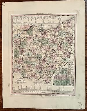
A New Map of Ohio with the Canals, Roads & Distances
Henry S. Tanner
Sold by mediumraremaps.com, Franklin, TN, U.S.A.
AbeBooks Seller since March 8, 2023
Used
Condition: Used - Very good
Ships within U.S.A.
Quantity: 1 available
Add to basketSold by mediumraremaps.com, Franklin, TN, U.S.A.
AbeBooks Seller since March 8, 2023
Condition: Used - Very good
Quantity: 1 available
Add to basketThis is a beautifully engraved map of the state of Ohio. Predominately displayed, the Canals stand out as the major characteristic of the state's landscape. There is an inset map of Cincinnati. Across the lower part of is an elevation profile of the Ohio Canal. Transportation is the overall theme of this map. At the time of the maps making, Cincinnati and its Ohio River commerce was the principal point of activity for the state. The wholesale tentacle of the city reached out along the Mississippi River. St. Louis at the time was an aspiring wholesale city beginning to compete with the Ohio River entrepôt. This is a fine example of the mapmakers art in 1836.
Seller Inventory # 346
All items will be sent with tracking. Receipt as noted by tracking information is ruling. We have a 30 days from receipt return policy. We must be notified prior to returm. Return cost are to be paid by the buyer unless there is a problem with the description. Our main aim is to have satisfied customers. Please feel free to contact us before and after buying an item or if you have any other questions.
Books, maps and prints will be sent flat or in a box or tube. Buyer pays 6.00 USD shipping. Orders are handled within 48 hours from receipt of payment.
| Order quantity | 5 to 14 business days | 3 to 6 business days |
|---|---|---|
| First item | US$ 6.00 | US$ 9.50 |
Delivery times are set by sellers and vary by carrier and location. Orders passing through Customs may face delays and buyers are responsible for any associated duties or fees. Sellers may contact you regarding additional charges to cover any increased costs to ship your items.