About this Item
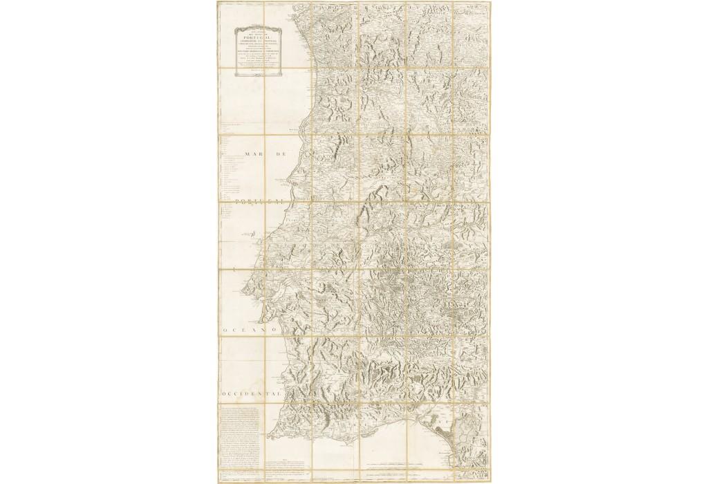
The scarce wall map issue of Tomás Lopez's magnificent map of Portugal, one of the finest national maps of the kingdom from the Enlightenment period. Tomás Lopez's large and beautifully engraved wall map of Portugal is a great work of Enlightenment era cartography, which appeared during a dramatic period in the history of Iberia. Printed in Madrid by Spain's leading cartographer, it is predicated on a carefully edited synthesis of the best available geographical sources. All of metropolitan Portugal unfolds in great detail, showcasing a wealth of information over the land's diverse topography. The map's 'Explicacion de las senales', or legend, located in the upper right, identifies literally dozens of different features, including cities and settlements of various sizes, townships, country stores, government offices, hunting reservations, forts, river quays, bridges, parish churches, archbishoprics and bishoprics, monasteries of various orders, colleges, jurisdictionaper, iron and tin), as well as various noble domains. The map also features an extensive network of roads, based on the descriptions of Juan Batista de Castro, as explained in the 'Nota' in the lower left quadrant of the map. The Making of Lopez's Mapa General del Reyno de Portugal As Spain's leading official cartographer, Lopez was well aware that the mapping of Portugal had both particular practical and symbolic significance. Spain had a long and very complex relationship with its Iberian neighbor, most recently attempting to invade Portugal during the Fantastic War of 1762-3 (an effort thwarted by British intervention). Gaining an accurate impression of Portugal's geography was of keen interest to both civilian officials and military leaders in Madrid, and Lopez's map was considered to be the authoritative map of Portugal available in Spain during the period spanning its creation up into the Napoleonic Wars. In devispez faced a great cas already quite familiar with the geography of Portugal, as he earlier created the Mapa del Reyno de Portugal Construido según las más modernas memorias (1762), which was much smaller and less accurate than the present map. However, while certain areas of Portugal had been mapped to a relatively high degree of accuracy, no broadly accurate general map of the country existed. The turmoil in the wake of the Great Lisbon Earthquake (1755), the Távora Affair (1758) and the Fantastic War created a climate of instability in which the sponsorship of a survey of Portugal was impossible. On May 30, 1777, Lopez applied to the Real Academia de la Historia for a license approving the publication of the map. In the process of the deliberations, on August 22, he submitted a document entitled "Relacíon de fuentes par Tomás Lopez para la confeccíon de mapa del reino de Portugal", in which he explains his sources to Don Pedro Rodríguez Campomanes, the directdemia (and the dedicatee of the maimself the author of fine map of Portugal. This document is summarized in the lower left quadrant of the present map. Lopez's sources were diverse and his letter indicates that he went to great lengths to carefully compare and analyze the best available maps in preparation of his own work. These included literally dozens of published and manuscript sources, such as Carlos de Grandprez's Carta topográfica del patriarcado de Lisboa (1736); Pedro Gendron's Mapa de Portugal (1754); Pedro Rodríguez de Campomanes Mapa de Portugal (1762); Jacques-Nicolas Bellin's Carte de Portugal (1762); Giovanni Rizzi-Zannoni's Carte de Portugal (1762). Lopez also studied written accounts of the geography of Portugal, including Gaspar Estazo's Antigüedades de Portugal and Luís Caetano de Lima's Geografia historica. Lopez's completed map represented a great accomplishment in that is was by far the most accurate and cleanly created to date. It remained an authoritativees and was used during the Peninsular War (1807-1814), during which Portugal was invaded by Spain and France, before. Seller Inventory # 62373
Contact seller
Report this item