
Palestine
Stanford, Edward
Publication Date: 1925
Used
From
Antiqua Print Gallery, London, United Kingdom
Seller rating 4 out of 5 stars
![]()
AbeBooks Seller since January 14, 2022
This specific copy is no longer available. Here are our closest matches for Palestine by Stanford, Edward.
About this Item
Description:
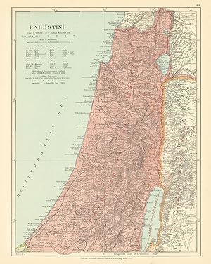
Palestine. "Mandated to Great Britain". Israel Transjordan. STANFORD c1925 map. Antique colour atlas map; Edward Stanford Ltd. (The map is undated; we estimate publication at either 1924 or 1925 based on the content of the maps within the atlas within which it was published). 36.0 x 28.5cm, 14 x 11.25 inches. Condition: Good. There is nothing printed on the reverse side, which is plain. Seller Inventory # P-7-017420
Bibliographic Details
Title: Palestine
Publication Date: 1925
Condition: Good
Top Search Results from the AbeBooks Marketplace

Seller Image
Palestine
Published by
Edward Stanford, London, 1904
Used
Seller: Crouch Rare Books, Godalming, United Kingdom
Seller rating 5 out of 5 stars
![]()
colour lithograph map from Stanford's London Atlas of 1904, 473 x 603 mm, relief shown by hachures, shows also part of Egypt, 'Country under Turkish rule coloured Green, Country under Egyptian rule coloured yellow', marginal age tears along creases one of which extends into map, several marginal chips well away from map, an attractive antique map suitable for mounting/framing. This is an original antique map. We do not sell reproductions or facsimiles. Seller Inventory # 7776
Quantity: 1 available
Seller Image
Arab Territories and Palestine
Used
Seller: Antiqua Print Gallery, London, United Kingdom
Seller rating 4 out of 5 stars
![]()
Condition: Good. Arab Territories & Palestine. Jewish Homeland/Balfour Declaration 1945 old map. Antique British Mandate era colour map; Stanford, London (1945). 27.5 x 21.5cm, 10.75 x 8.25 inches; this is a folding map. Condition: Good. There text and data relating to the map printed on the reverse side. The map shows in Green "Arab Territories liberated by the [Second World War] and now independent or on the way to independence". Diagonal stripes (Purple/Green): "Eastern Palestine (Trans-Jordan); originally included in the area covered by the Balfour Declaration, and severed from Western Palestine in 1922 and excluded from the provisions regarding the Jewish National Home." Purple: "Western Palestine. The area in which the Jewish National Home clauses of the Mandate apply. The area of this territory is less than One per cent of the total area of the countries under Arab rule.". Seller Inventory # P-6-108028
Quantity: 1 available

'PALESTINE'. Highly detailed map with the pilgrims road (Derb el Haj).
Published by
Edward Stanford 1894, 1894
Used
Seller: Garwood & Voigt, Sevenoaks, United Kingdom
Seller rating 5 out of 5 stars
![]()
60x41cm. Printed in full colours. Seller Inventory # 24425
Quantity: 1 available
'PALESTINE'. Highly detailed map showing Railways and the pilgrims road (Derb el Haj)
Published by
Edward Stanford 1904, 1904
Used
Seller: Garwood & Voigt, Sevenoaks, United Kingdom
Seller rating 5 out of 5 stars
![]()
60x41cm. Printed in full colours. Seller Inventory # 24462
Quantity: 1 available
Seller Image
Palestine
Used
Seller: Antiqua Print Gallery, London, United Kingdom
Seller rating 4 out of 5 stars
![]()
Condition: Good. Palestine Holy Land Israel. Biblical & historical names. STANFORD 1896 old map. Large (folio) antique atlas map; Stanford's Geographical Establishment (1896). 63.5 x 51.0cm, 25 x 20 inches; this is a folding map. Condition: Good. The image shown may have been taken from a different example of this map than that which is offered for sale. The map you will receive is in good condition but there may be minor variations in the condition from that shown in the image. There is nothing printed on the reverse side, which is plain. Seller Inventory # P-8-005136
Quantity: 1 available
Seller Image
Palestine
Used
Seller: Antiqua Print Gallery, London, United Kingdom
Seller rating 4 out of 5 stars
![]()
Condition: Fair. Palestine Holy Land Israel. Biblical & historical names. STANFORD 1894 old map. Large (folio) antique atlas map; Stanford's Geographical Establishment (1894). 63.5 x 51.0cm, 25 x 20 inches; this is a folding map. Condition: Fair: Light soiling. There is nothing printed on the reverse side, which is plain. Seller Inventory # P-8-004741
Quantity: 1 available
Two maps, a travel guide, and framed photograph belonging to Luigi Gabbrielli, Fascist Italy's Consul-General to Palestine and Minister to Iraq] 1. Asia Minore: Armenia, Caucasia Merid., Siria, Mesopotamia e Regioni Adiacenti (Edizione Provvisoria) N. 558 - 1920 / 2. Stanford's Map of the Middle East / 3. A Guide Through the ruins of Babylon and Borsippa (With 18 pictures and 2 maps) / 4. Photograph] Sir Percy Z Cox's "Banogue" (P. Wilson up)
Published by
Ministero delle Colonie, Ufficio Cartografico; Edward Stanford; Government Press; Kerim Studio, Roma, London, Baghdad, 1919
Used
Seller: Dendera, London, United Kingdom
Seller rating 5 out of 5 stars
![]()
No Binding. Condition: Good. Luigi Gabbrielli (1885-?) was Italy's Consul General in Jerusalem from 1930 then Minister in Baghdad. After Iraq cut relations with Germany at the start of WW2 Gabbrielli led the Axis' anti-British propaganda efforts with the support of the Grand Mufti of Jerusalem Amin al Husseini. This culminated in the Axis-supported Golden Square Coup (1 April 1941) which brought Rashid Ali al Gaylani to power. In the ensuing Anglo-Iraqi War (2-31 May) the British ousted Gaylani, restoring pro-British Regent Abd al-Ila. Gabbrielli, Gaylani, and the Grand Mufti fled together to Iran. With them was Fritz Grobba, Nazi Germany's former Minister to Iraq and Saudi Arabia who had facilitated the training of anti-imperialist Iraqi officers in Germany (the four leading members of which nicknamed the "Golden Square") and transfer of German military advisors to Baghdad. 1. MAP: Dardano, A (Capo Cartografo) Asia Minore: Armenia, Caucasia Merid., Siria, Mesopotamia e Regioni Adiacenti (Edizione Provvisoria) N. 558 - 1920, Roma : Ministero delle Colonie, Ufficio Cartografico Colour folding map dated 1919 and 1920, 1:3,000,000, 85 x 70cm dissected in 36 sections mounted on linen, uncased. Colour coding shows political interests (Ottoman, Russia, Persia, Italy, Britain, Greece) with Ottoman administrative boundaries, railways and tracks. Labelled in Italian with Italian-Turkish glossary. This and the Stanford map have almost identical geographical coverage. Some lifting from linen, scuffing and staining. A couple of routes into the Syrian Desert have been drawn in blue crayon. Gabrielli's bookplate to verso with name and date in blue crayon (Gabbrielli Bagdad 1936). Rare - 4 copies on Worldcat (University of Illinois, BnF, Staatsbibliothek zu Berlin, Biblioteca Nacional de Espana). None on Jisc. 2. MAP: Stanford's Map of the Middle East, London: Edward Stanford, 1936. Colour map 103 x 73cm dissected in 32 sections backed on linen, uncased. Dated 26 June 1936 (from the code 26636). 1:2,500,000. Borders are colour shaded, demarcating the British and French Mandates. Features include military and civil aerodromes and landing grounds, and oil fields. Major pipelines are shown including Kirkuk to Haifa and Tripoli with its pumping stations (this began operation in 1935), and the Anglo Persian Oil Company Pipeline terminating at Abadan. Railways including the Hejaz and Baghdad lines are marked with their stations. In the more sparsely populated areas, wells, waterholes, jebels and wadis are individually named and desert routes shown. Very good with pinholes to the edges. Gabrielli's bookplate to verso with name and date in blue crayon (Gabbrielli Bagdad 1940). Stanford issued a few editions in the 1930s which are now rare. Worldcat and Jisc record editions for 1933, 1939, 1940. 3. GUIDE: Jordan, J. Department of Antiquities A Guide Through the ruins of Babylon and Borsippa With 18 pictures and 2 maps, Baghdad: Government Press, 1937 First and only edition. Printed blue wraps 15 x 21cm. 21pp + 18 full page b/w figures + 2 folding maps as called for (I. Babylon, II. The Inner Town of Babylon) with errata slip laid in. Wraps good, fading to edges. Interiors good, foxed with faint damp stain at fore-edge. Maps neatly folded. The author was Technical Advisor to the Antiquities Department. Gabbrielli's bookplate inside front wrap. 4. PHOTO: Sir Percy Z Cox's "Banogue" (P. Wilson up), Baghdad: Kerim Studio, nd, c 1920s B/w photo 29 x 24cm with pencilled caption mounted in contemporary wood frame 47 x 37cm by Abdul Kerim. The photo shows a racehorse belonging to former British High Commissioner to Iraq Sir Percy Zachariah Cox with its rider P. Wilson. Aside from the caption there are no ownership marks, and it is not clear how this came into Gabbrielli's possession. Seller Inventory # 3833
Quantity: 1 available