Set of 3 1970s Lin Ottinger Maps
Gal, Jean-Claude
Published by Lin Ottinger Tours, Moab, UT
Used
Maps
From
Back of Beyond Books, Moab, UT, U.S.A.
Seller rating 5 out of 5 stars
![]()
AbeBooks Seller since February 2, 2007
Association Member:
This book is no longer available. AbeBooks has millions of books. Please enter search terms below to find similar copies.
About this Item
Description:
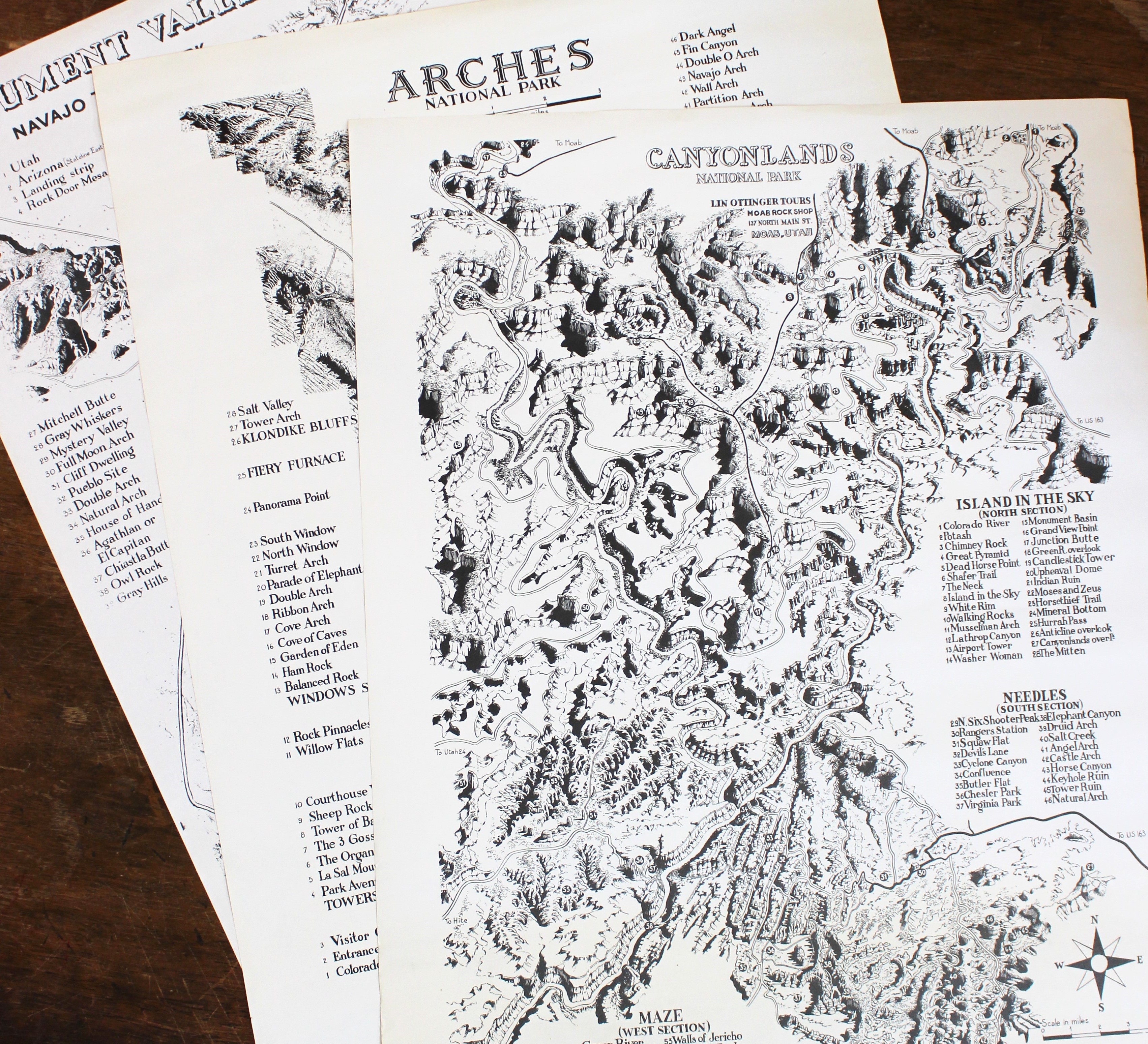
Set of three maps produced by Lin Ottinger in Moab, Utah during the 1970s. Set includes maps of Arches National Park (1973) , Canyonlands National Park (1972) , and Monument Valley Navajo Tribal Park (1975). Each map is printed in black-and-white and measures approximately 22 x 17 inches. All are in very good condition with minor creasing to edges. Canyonlands map has light toning to bottom 5 inches. Versos are blank. All were drawn by French comic artist Jean-Claude Gal. Set was previously owned by W. L. "Bud" Rusho (1928-2011) , a western historian, author, and photographer who is best known for his work about Everett Ruess. Includes a TLS that is signed by Ottinger granting Rusho permission to use the maps in any of his publications. These maps show the topography of three iconic parks and mark all the major landmarks. A great Southeastern Utah piece with interesting provenance. ; B&W Illustrations. Seller Inventory # 024932
Bibliographic Details
Title: Set of 3 1970s Lin Ottinger Maps
Publisher: Lin Ottinger Tours, Moab, UT
Binding: Maps
Condition: Very Good
AbeBooks offers millions of new, used, rare and out-of-print books, as well as cheap textbooks from thousands of booksellers around the world. Shopping on AbeBooks is easy, safe and 100% secure - search for your book, purchase a copy via our secure checkout and the bookseller ships it straight to you.
Search thousands of booksellers selling millions of new & used books
New & Used Books

New and used copies of new releases, best sellers and award winners. Save money with our huge selection.
Rare & Out of Print Books

From scarce first editions to sought-after signatures, find an array of rare, valuable and highly collectible books.
