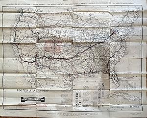
United States Map Transcontinental Highways and Main Trunk Line Railroads West of Chicago
Clason Map Company. Denver Tourist & Publicity Bureau
Sold by mediumraremaps.com, Franklin, TN, U.S.A.
AbeBooks Seller since March 8, 2023
Sold by mediumraremaps.com, Franklin, TN, U.S.A.
AbeBooks Seller since March 8, 2023
This is a superb cartographic artifact from the early years of automobile travel. The map is unusual in its large scale. Clason maps are generally a much smaller scale and usually state-centric. This map is rare with WorldCat locating two editions with a total of four copies. This map was used by a well travelled person. The user followed the trail system and marked the routes with blue and red markings. The pre-Federal highway numbering system of Trails dominates the map. The user travelled some trails more than once. Most prominent is the use of the National Old Trails road which was the predecessor to Route 66. Route 66 was introduced in 1926. The National Old Trails road was also known as the Coast-to-Coast highway. The road ran from Baltimore MD to Santa Monica, CA. This map's user travelled the most parts of the road. The Old Spanish Trail was traversed from St Augustine to San Diego. Red markings indicate the portions traveled each day. Multiple other trails were used as listed in the Trails index on the map, including the Oregon Trail.This map is a critical document in the history of transportation. It freezes a time where the consciousness of the traveling public had expanded and opened to the concept of transcontinental travel by car. The map's user chronicled that travel and the journeys are here recorded. The map is undated but WorldCat shows 1920 for the other non-Denver edition. This would be the same or only slightly thereafter. The period precedes heavy Federal involvement with the consciousness of long distance travel by car in its infancy. This is a rarity and an exception period documentation of the road well travelled. Good condition having been used as a travel document. Some tears at the fold intersection and overall mild soiling. The tears have been repaired with archival mending tape. Single sheet Wall Map measuring 32 x 26 inches WorldCat lists two editions with only four total locations found.
Seller Inventory # 304
All items will be sent with tracking. Receipt as noted by tracking information is ruling. We have a 30 days from receipt return policy. We must be notified prior to returm. Return cost are to be paid by the buyer unless there is a problem with the description. Our main aim is to have satisfied customers. Please feel free to contact us before and after buying an item or if you have any other questions.
Books, maps and prints will be sent flat or in a box or tube. Buyer pays 6.00 USD shipping. Orders are handled within 48 hours from receipt of payment.
| Order quantity | 5 to 14 business days | 3 to 6 business days |
|---|---|---|
| First item | US$ 6.00 | US$ 9.50 |
Delivery times are set by sellers and vary by carrier and location. Orders passing through Customs may face delays and buyers are responsible for any associated duties or fees. Sellers may contact you regarding additional charges to cover any increased costs to ship your items.