
Die neuwen inseln so hinder Hispanien gegen Orient bey dem Land Indie ligen
MUNSTER, Sebastian
Published by Heinrich Petri, Basel, 1572
Used
unbound
From
Argosy Book Store, ABAA, ILAB, New York, NY, U.S.A.
Seller rating 5 out of 5 stars
![]()
Heritage Bookseller
AbeBooks member since 1996
This book is no longer available. AbeBooks has millions of books. Please enter search terms below to find similar copies.
About this Item
Description:
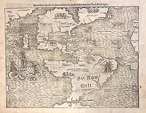
Map. Uncolored woodcut. Sheet measures 12" x 15.25". This important and influential 1572 map by Sebastian Munster is the first map to show North America and South America in their true continental forms. It is also significant in that it names the Pacific Ocean (Mare Pacificum) and the first printed map to ever show Japan (Zipangri), here appearing based on the accounts of Marco Polo. First published in 1544 in his Basel edition of Ptolemy's "Geographia", this map made several appearances in about 40 subsequent editions in 6 different languages. This particular map is the 13th state and appeared in the 1572 German edition of Munster's "Cosmographia". The map established some notable cartographic conventions of the time.Most notable is the oddly shaped North America without the California landmass. Florida, clearly identifiable, is connected by a narrow isthmus to "Francisca" further north east. Presumably so named after Francis I who sponsored Verrazano's expedition. This reflects the belief at the time of the Sea of Verrazano, a possible route to the West Indies. Yucatan appears as an island and Temistian empties into the Caribbean.A more recognizable South America depicts a bulging northwest and notes the region supposedly inhabited by Cannibals in modern day Brazil, with a vignette depicting human body parts. The map includes a very early appearance of the Straits of Magellan. Magellan's ship 'Victoria' also appears in the Pacific. A Spanish flag is seen flying on Puerto Rico while a Portuguese Flag appears in the South Atlantic, depicting their respective influence in the New World. Munster's inclusion of this map in his popular 1544 edition of "Cosmpgraphia" is also believed to have sealed the fate of "America" as the name for the New World.The map is in good condition with minor foxing at places. Minor wear along original centerfold and verso repair near top center margin.Claudius Ptolemy (90-168 CE) was a Roman geographer and mathematician living in Egypt, who compiled his knowledge and theories about the world's geography into one seminal work. Although his maps did not survive, his mathematical projections and location coordinates did. During the Renaissance revival of Greek and Roman works, "Geographia" was rediscovered by monks and based upon Ptolemy's detailed instructions, the maps were recreated. The first printed edition of "Geographia" with maps was published in Bologna in 1477.Professor Sebastian Munster (1488-1552) was a German cosmographer, humanist, theologian and scholar. His seminal work "Cosmographia" was published in numerous languages and is considered the most popular book of the 16th century. Furthermore, Munster is also credited with contributing to a revival of geography in Germany. This example is an exceptional example of this influential map. Seller Inventory # 273032
Bibliographic Details
Title: Die neuwen inseln so hinder Hispanien gegen ...
Publisher: Heinrich Petri, Basel
Publication Date: 1572
Binding: unbound
AbeBooks offers millions of new, used, rare and out-of-print books, as well as cheap textbooks from thousands of booksellers around the world. Shopping on AbeBooks is easy, safe and 100% secure - search for your book, purchase a copy via our secure checkout and the bookseller ships it straight to you.
Search thousands of booksellers selling millions of new & used books
New & Used Books

New and used copies of new releases, best sellers and award winners. Save money with our huge selection.
Rare & Out of Print Books

From scarce first editions to sought-after signatures, find an array of rare, valuable and highly collectible books.
