About this Item
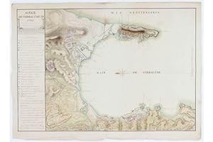
MONTFERRIER, Sarrazin de (1792-1863). Siege de Gibraltar en 1782. Sous les ordres de M.r Le Duc de Crillon Mahon. Marseille: 1810 Single sheet (18 6/8 x 25 6/8 inches). EXCEPTIONALLY FINE MANUSCRIPT MAP OF GIBRALTAR, pen and ink and colour wash on paper watermarked "C & I Honig"; oriented to the east and showing the bay, the famous Rock, the settlements and fortifications in great detail, decorated with a fine compass rose, the title within an allegorical header above a comprehensive key and an extensive note about the map, place names in Spanish, signed by Montferrier lower right (old vertical and horizontal folds). Annexed by Queen Isabella of Spain in 1501, it was nearly 200 years later, in 1704, during the War of the Spanish Succession, that Sir George Rooke captured Gibraltar for the British, and Spain formally ceded it to Britain under the terms of the Treaty of Utrecht in 1713. The Spanish nevertheless made several attempts to retake Gibraltar from Britain, most notably in a protracted but unsuccessful military siege that lasted from 1779 to 1783. In 1830 Gibraltar became a British crown colony. Following the outbreak of the American War of Independence, France and Spain joined forces to supply funding and arms to the American rebels, and so defeat Britain. On the 12th of April in 1779, France and Spain formalised their intent by signing the Treaty of Aranjuez in which they agreed to help each other recover lost territory from Britain, including Gibraltar, which was key to controlling the Mediterranean. So the Great Siege of Gibraltar began in earnest, and lasted nearly four long years. The British were able to relieve their besieged troops twice during that time. Eventually on September 13, 1782, the Bourbon allies launched a great attack, which failed when their ships and floating batteries were set fire to by red-hot shot which the British rained down on them. At last the Royal Navy sent relief and in September of 1782 a large fleet left Spithead under Richard Howe, arriving off Cape St Vincent on the 9th of October. The following evening a gale blew up, scattering the Spanish and French fleet, allowing Howe to sail unopposed into Gibraltar. The siege continued few a months more until the French and Spanish troops finally retired disheartened and defeated. This fine manuscript map, that shows the joint French and Spanish ambition towards Gibraltar was commissioned by Louis des Balbes de Berton de Crillon (1717 1796), he was the 4th Duke of Crillon and 1st Duke of Mahon. A star in the French army from a very early age, Crillon moved to Spain in 1762, where he rose throught he ranks to achieve the highest of commands in the Bourbon arm, and was made a Knight of the Order of Charles III in 1780. During the American War of Independence, when Spain and France allied with the Americans to fight Britain, he was given command of a Spanish army tasked with capturing Minorca from the British. The army landed on the island on 19 August 1781 and laid siege to the British garrison in Fort St. Philip at Mahon. The siege was concluded successfully on 5 February 1782 when the British surrendered, for which Crillon was made a grandee of Spain and took the title of Duke of Crillon-Mahon. He was subsequently put in charge of the joint French and Spanish force that had been besieging Gibraltar since 1779. Despite his efforts, Gibraltar proved impregnable. Nevertheless Crillon was further rewarded with the title of Knight of the Golden Fleece in 1783. Not much is known of Montferrier, except that at the time this map was drawn he was Captain of the Royal Engineers in the Bourbon army. He published works of mathematics and created other maps of Senegal. Seller Inventory # 72map420
Contact seller
Report this item
