Items related to Israel Map (National Geographic Adventure Map, 3208)

� Waterproof � Tear-Resistant � Travel Map
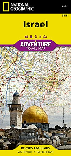
National Geographic's Israel Adventure Map is the perfect travel companion for Holy Land adventure travelers. This expertly researched map details the country with unparalleled information not found in traditional road maps. Hundreds of diverse and unique recreational, ecological, cultural, and historic destinations are pinpointed, including many hidden gems, such as Islamic and Jewish sacred sites, churches, mosques, archeological site, beaches, hotels, hostels, airports and harbors. A clearly marked network of both primary and secondary roads, shown with distances, along with an index of cities and towns will guide you on your adventure, while mapped hiking trails, including The Israel Trail, will help you get off the beaten path.
This comprehensive map covers Israel in its entirety and complements any guidebook to the region. Also shown are Palestinian areas in the West Bank and Gaza Strip and bordering areas in Jordan, Syria and Lebanon. The country's three most populated cities Jerusalem, Tel-Aviv and Haifa can be found on the map's northern side, along with the Sea of Galilee (Kinneret), Nazareth, the Golan Heights and most of the Dead Sea. The map's southern side covers the cities of Be'ersheva, Hebron, Bethlehem and Eilat along with the Gaza Strip, Dead Sea, the ancient fortification of Masada and the Jordanian city of Aqaba.
Every Adventure Map is printed on durable synthetic paper, making them waterproof, tear-resistant and tough — capable of withstanding the rigors of international travel.
- Map Scale = 1:275,000
- Sheet Size = 25.5" x 37.75"
- Folded Size = 4.25" x 9.25"
"synopsis" may belong to another edition of this title.
About the Author:
Founded in 1915 as the Cartographic Group, the first division of National Geographic, National Geographic Maps has been responsible for illustrating the world around us through the art and science of mapmaking.Today, National Geographic Maps continues this mission by creating the world's best wall maps, recreation maps, atlases, and globes which inspire people to care about and explore their world.
"About this title" may belong to another edition of this title.
- PublisherNatl Geographic Society Maps
- Publication date2019
- ISBN 10 156695617X
- ISBN 13 9781566956178
- BindingMap
- Number of pages2
- Rating
Buy New
Learn more about this copy
US$ 12.71
Shipping:
FREE
Within U.S.A.
Top Search Results from the AbeBooks Marketplace
Seller Image
Israel (Sheet Mapsheet Map - Detail Un)
Published by
National Geographic Maps 6/15/2012
(2012)
ISBN 10: 156695617X
ISBN 13: 9781566956178
New
Quantity: 5
Seller:
Rating
Book Description Sheet Mapsheet Map - Detail Un. Condition: New. Israel 0.2. Book. Seller Inventory # BBS-9781566956178
Buy New
US$ 12.71
Convert currency
Stock Image
Israel (National Geographic Adventure Map)
Published by
National Geographic Maps
(2019)
ISBN 10: 156695617X
ISBN 13: 9781566956178
New
Quantity: 14
Seller:
Rating
Book Description Condition: New. Brand New! Not Overstocks or Low Quality Book Club Editions! Direct From the Publisher! We're not a giant, faceless warehouse organization! We're a small town bookstore that loves books and loves it's customers! Buy from Lakeside Books!. Seller Inventory # OTF-9781566956178
Buy New
US$ 10.79
Convert currency
Stock Image
Israel Map (National Geographic Adventure Map, 3208)
Published by
Natl Geographic Society Maps
(2019)
ISBN 10: 156695617X
ISBN 13: 9781566956178
New
Quantity: 1
Seller:
Rating
Book Description Condition: New. Book is in NEW condition. Seller Inventory # 156695617X-2-1
Buy New
US$ 16.96
Convert currency
Stock Image
Israel Map (National Geographic Adventure Map, 3208)
Published by
Natl Geographic Society Maps
(2019)
ISBN 10: 156695617X
ISBN 13: 9781566956178
New
Quantity: 1
Seller:
Rating
Book Description Condition: New. New! This book is in the same immaculate condition as when it was published. Seller Inventory # 353-156695617X-new
Buy New
US$ 16.97
Convert currency
Stock Image
Israel Map (National Geographic Adventure Map, 3208)
Published by
Natl Geographic Society Maps
(2019)
ISBN 10: 156695617X
ISBN 13: 9781566956178
New
Quantity: > 20
Seller:
Rating
Book Description Condition: New. Seller Inventory # I-9781566956178
Buy New
US$ 17.00
Convert currency
Stock Image
Israel AdventureMap
Published by
National Geographic Maps
(2012)
ISBN 10: 156695617X
ISBN 13: 9781566956178
New
Quantity: 1
Seller:
Rating
Book Description Map. Condition: New. Seller Inventory # DADAX156695617X
Buy New
US$ 17.16
Convert currency
Stock Image
Israel Travel Maps International Adventure Map National Geographic Adventure Map
Published by
National Geographic Maps
(2012)
ISBN 10: 156695617X
ISBN 13: 9781566956178
New
Quantity: 15
Seller:
Rating
Book Description UNK. Condition: New. New Book. Shipped from UK. Established seller since 2000. Seller Inventory # IB-9781566956178
Buy New
US$ 20.85
Convert currency
Seller Image
Israel (Folded)
Published by
National Geographic Maps, Evergreen
(2012)
ISBN 10: 156695617X
ISBN 13: 9781566956178
New
Quantity: 1
Seller:
Rating
Book Description Folded. Condition: new. Folded. National Geographic's Israel Adventure Map is designed to meet the unique needs of adventure travelers with its durability and accurate information. This folded map provides global travelers with the perfect combination of detail and perspective, highlighting hundreds of points of interest and the diverse and unique destinations within the country. The map includes the locations of cities and towns with a user-friendly index, plus a clearly marked road network complete with distances and designations for major highways, main roads, and tracks and trails for those seeking to explore more remote regions. The front side of the Israel map details the northern region of the country, from its border with Lebanon to the north, to Syria and Jordan to the east and the Mediterranean Sea to the west. The reverse side of the map details Israel's southern region; bordering Jordan to the east, Egypt and the Mediterranean Sea to the west, and the Gulf of Aqaba to the southernmost point. Every Adventure Map is printed on durable synthetic paper, making them waterproof, tear-resistant and tough capable of withstanding the rigors of international travel. Each is two-sided and can be folded to a packable size of 235 x 108 mm; unfolded size is 965 x 660 mm. AdventureMaps provide global travellers with the perfect combination of detail and perspective, highlighting hundreds of points of interest and the diverse and unique destinations within the country. Each map is printed on durable synthetic paper, making them waterproof and tear-resistant. They also include the locations of cities and towns with a user-friendly index, plus a clearly marked road network complete with distances and designations for major highways, main roads and tracks and trails for those seeking to explore more remote regions. Scale : 1:275,000 Flat Size : 0 x 0 mm. Shipping may be from multiple locations in the US or from the UK, depending on stock availability. Seller Inventory # 9781566956178
Buy New
US$ 21.72
Convert currency
Stock Image
Israel
Published by
National Geographic Maps Division 2012-04-30, Washington, D.C.
(2012)
ISBN 10: 156695617X
ISBN 13: 9781566956178
New
Quantity: 5
Seller:
Rating
Book Description sheet map (folded). Condition: New. Language: ENG. Seller Inventory # 9781566956178
Buy New
US$ 19.28
Convert currency
Stock Image
Israel
Published by
NATL GEOGRAPHIC MAPS
(2019)
ISBN 10: 156695617X
ISBN 13: 9781566956178
New
Quantity: 15
Seller:
Rating
Book Description Books. Condition: New. Special order direct from the distributor. Seller Inventory # ING9781566956178
Buy New
US$ 14.95
Convert currency