Synopsis
• Waterproof • Tear-Resistant • Travel Map
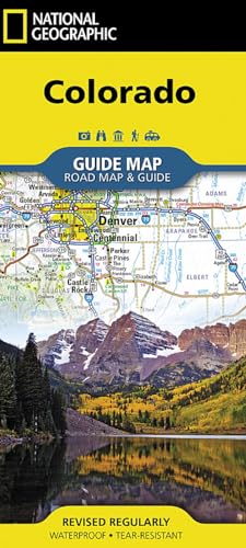
National Geographic's Colorado Guide Map is designed to meet the needs of travelers with detailed and accurate cartography and loads of helpful information about the state's many attractions. Cities and towns are easy to find with the map's helpful index. Highways, roadways, toll roads, scenic routes, and other roads are clearly designated. Distances in miles are noted on major highways so travelers can easily plan their best route. Hundreds of points of interest are shown, along with national and state parks, public campsites, visitor information centers, airports, ski areas, hospitals, and more.
Inset maps of Denver, Colorado Springs, Pueblo, Fort Collins, Mesa Verde National Park, and Rocky Mountain National Park provide greater detail of key areas of the state. A map of the San Juan Skyway highlights one of Colorado's many scenic drives. The information provided about points of interest, Denver, and Rocky Mountain and Mesa Verde national parks will help you take advantage of many sites and recreation activities the state has to offer. A handy chart of park service sites and climate information are also included.
Every State Guide Map is printed on durable synthetic paper, making them waterproof, tear-resistant and tough — capable of withstanding the rigors of any kind of travel.
- Map Scale = 1:1,584,000
- Sheet Size = 17.75" x 20.75"
- Folded Size = 4" x 8.75"
"synopsis" may belong to another edition of this title.
About the Author
Founded in 1915 as the Cartographic Group, the first division of National Geographic, National Geographic Maps has been responsible for illustrating the world around us through the art and science of mapmaking.Today, National Geographic Maps continues this mission by creating the world's best wall maps, recreation maps, atlases, and globes which inspire people to care about and explore their world.
"About this title" may belong to another edition of this title.
Search results for Colorado Map (National Geographic Guide Map)

Stock Image
Colorado Map (Folded)
Published by
National Geographic Maps, Evergreen, 2018
ISBN 10: 156695777X
ISBN 13: 9781566957779
New
Seller: Grand Eagle Retail, Bensenville, IL, U.S.A.
Seller rating 5 out of 5 stars
![]()
Folded. Condition: new. Folded. Waterproof Tear-Resistant Travel MapNational Geographic's Colorado Guide Map is designed to meet the needs of travelers with detailed and accurate cartography and loads of helpful information about the state's many attractions. Cities and towns are easy to find with the map's helpful index. Highways, roadways, toll roads, scenic routes, and other roads are clearly designated. Distances in miles are noted on major highways so travelers can easily plan their best route. Hundreds of points of interest are shown, along with national and state parks, public campsites, visitor information centers, airports, ski areas, hospitals, and more.Inset maps of Denver, Colorado Springs, Pueblo, Fort Collins, Mesa Verde National Park, and Rocky Mountain National Park provide greater detail of key areas of the state. A map of the San Juan Skyway highlights one of Colorado's many scenic drives. The information provided about points of interest, Denver, and Rocky Mountain and Mesa Verde national parks will help you take advantage of many sites and recreation activities the state has to offer. A handy chart of park service sites and climate information are also included.Every State Guide Map is printed on durable synthetic paper, making them waterproof, tear-resistant and tough capable of withstanding the rigors of any kind of travel. Shipping may be from multiple locations in the US or from the UK, depending on stock availability. Seller Inventory # 9781566957779
Stock Image
Colorado Map
Seller: PBShop.store US, Wood Dale, IL, U.S.A.
Seller rating 5 out of 5 stars
![]()
UNK. Condition: New. New Book. Shipped from UK. Established seller since 2000. Seller Inventory # EA-9781566957779
Stock Image
Colorado Map
Seller: PBShop.store UK, Fairford, GLOS, United Kingdom
Seller rating 5 out of 5 stars
![]()
UNK. Condition: New. New Book. Shipped from UK. Established seller since 2000. Seller Inventory # EA-9781566957779
Buy New
US$ 19.54
US$ 4.42 shipping
Ships from United Kingdom to U.S.A.
Ships from United Kingdom to U.S.A.
Quantity: 15 available
Stock Image
National Geographic Guide Map Colorado: Road Map & Guide
Seller: Revaluation Books, Exeter, United Kingdom
Seller rating 5 out of 5 stars
![]()
Paperback. Condition: Brand New. fol map edition. 1 pages. 9.00x4.00x0.20 inches. In Stock. Seller Inventory # xr156695777X
Buy New
US$ 11.97
US$ 13.42 shipping
Ships from United Kingdom to U.S.A.
Ships from United Kingdom to U.S.A.
Quantity: 2 available
Stock Image
Colorado (National Geographic Guide Map)
Seller: Russell Books, Victoria, BC, Canada
Seller rating 5 out of 5 stars
![]()
Map. Condition: New. Special order direct from the distributor. Seller Inventory # ING9781566957779
Seller Image
Colorado Map (Folded)
Published by
National Geographic Maps, Evergreen, 2018
ISBN 10: 156695777X
ISBN 13: 9781566957779
New
Seller: AussieBookSeller, Truganina, VIC, Australia
Seller rating 5 out of 5 stars
![]()
Folded. Condition: new. Folded. Waterproof Tear-Resistant Travel MapNational Geographic's Colorado Guide Map is designed to meet the needs of travelers with detailed and accurate cartography and loads of helpful information about the state's many attractions. Cities and towns are easy to find with the map's helpful index. Highways, roadways, toll roads, scenic routes, and other roads are clearly designated. Distances in miles are noted on major highways so travelers can easily plan their best route. Hundreds of points of interest are shown, along with national and state parks, public campsites, visitor information centers, airports, ski areas, hospitals, and more.Inset maps of Denver, Colorado Springs, Pueblo, Fort Collins, Mesa Verde National Park, and Rocky Mountain National Park provide greater detail of key areas of the state. A map of the San Juan Skyway highlights one of Colorado's many scenic drives. The information provided about points of interest, Denver, and Rocky Mountain and Mesa Verde national parks will help you take advantage of many sites and recreation activities the state has to offer. A handy chart of park service sites and climate information are also included.Every State Guide Map is printed on durable synthetic paper, making them waterproof, tear-resistant and tough capable of withstanding the rigors of any kind of travel. Shipping may be from our Sydney, NSW warehouse or from our UK or US warehouse, depending on stock availability. Seller Inventory # 9781566957779
Buy New
US$ 48.74
US$ 37.00 shipping
Ships from Australia to U.S.A.
Ships from Australia to U.S.A.
Quantity: 1 available