
L'ISLE DE ST. DOMINGUE ET CELLE DE PORTO-RICO.
BONNE, R.
Published by Paris. c1787
Used
From
Peter Harrington. ABA/ ILAB., London, United Kingdom
Seller rating 5 out of 5 stars
![]()
AbeBooks Seller since July 26, 1999
This specific copy is no longer available. Here are our closest matches for L'ISLE DE ST. DOMINGUE ET CELLE DE PORTO-RICO..
About this Item
Description:
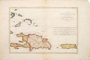
A map of the French/Spanish Caribbean island of what is today Haiti and Santa Domingo, together with that of neighbouring Porto-Rico. Size: 310 x 465 mm. Copperplate engraving with later hand colouring. Fair condition. Some foxing. Margins chipped. Seller Inventory # 65656
Bibliographic Details
Title: L'ISLE DE ST. DOMINGUE ET CELLE DE ...
Publisher: Paris. c1787
Top Search Results from the AbeBooks Marketplace

Seller Image
L'Isle De ST DOMINGUE et celle de PORTO - RICO. Atlas Encyclop�dique contenant la g�ographie ancienne et moderne Hotel de Thou 1787-1788.
Published by
Desmarets, Hotel de Thou 1787/1788 Paris, 1788
Used
Seller: E. & J.L GRISON, TOULON, France
Seller rating 5 out of 5 stars
![]()
1 carte 25 x 36 cm, sur beau papier de chiffon XVIII�, extraite de l'Atlas Encyclop�dique section g�ographie moderne, de DESMAREST, �dit� en 1787/1788. Carte double page, mont�e sur onglet (qui peut �tre d�coll� pour supprimer la trace de pliure). Carte finement grav�e, en parfait �tat. L�g�re trace du pliage � l'onglet. Seller Inventory # 3012
Quantity: 1 available
L'Isle de St Domingue et celle de Porto-Rico [The islands of Hispaniola and Puerto Rico]
Used
Seller: Antiqua Print Gallery, London, United Kingdom
Seller rating 4 out of 5 stars
![]()
Condition: Good. L'Isle de St Domingue et Porto-Rico. Hispaniola & Puerto Rico. BONNE 1788 map. Antique 18th century copperplate map; Rigobert Bonne (1788). 24.5 x 36.0cm, 9.5 x 14.25 inches; this is a folding map. Condition: Good. Toning along centrefold. There is nothing printed on the reverse side, which is plain. Seller Inventory # P-6-019820
Quantity: 1 available
Seller Image
L'Isle de St Domingue, et celle de Porto-Rico
Published by
Paris, 1771, 1771
Used
Seller: Pennymead Books PBFA, Knaresborough, United Kingdom
Seller rating 5 out of 5 stars
![]()
Engraved map of the Dominican Republic and Haiti and Puerto Rico. Very fine condition. 14 x 10". Seller Inventory # BONNEM020377
Quantity: 1 available
Seller Image
L'Isle de St Domingue, et celle de Porto-Rico
Published by
Paris, 1771, 1771
Used
Seller: Pennymead Books PBFA, Knaresborough, United Kingdom
Seller rating 5 out of 5 stars
![]()
Engraved map of the Dominican Republic and Haiti and Puerto Rico. Hand coloured outline. Very fine condition. 14 x 10in. Seller Inventory # BONNEM020380
Quantity: 1 available
Seller Image
L'Isle de St. Domingue et celle de Porto Rico
Published by
Santo Domingo - Porto Rico
Used
Seller: Sergio Trippini, Gavirate, Italy
Seller rating 5 out of 5 stars
![]()
Carta geografica, antica ed originale, raffigurante l'isola di Santo Domingo e Porto Rico. Piega centrale editoriale.Rigobert Bonne (1727-1795) fu uno dei pi� importanti cartografi del tardo XVIII secolo. Nel 1773 succedette a Jacques Bellin come cartografo reale in Francia. Seller Inventory # ST50757
Quantity: 1 available