


(Pacific Railroad Surveys) Reports of Explorations and Surveys, to Ascertain the Most Practicable and Economical Route for a Railroad from the Mississippi River to the Pacific Ocean [with:] Map of the Territory of the United States from the Mississippi to the Pacific Ocean
Davis
Published by Davis, 1855
Used
Hardcover
From
Barry Lawrence Ruderman, La Jolla, CA, U.S.A.
Seller rating 5 out of 5 stars
![]()
AbeBooks Seller since August 31, 2022
This book is no longer available. AbeBooks has millions of books. Please enter search terms below to find similar copies.
About this Item
Description:
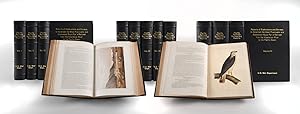
Davis / 1855 - 1860 / (Pacific Railroad Surveys) Reports of Explorations and Surveys, to Ascertain the Most Practicable and Economical Route for a Railroad from the Mississippi River to the Pacific Ocean [with:] Map of the Territory of the United States from the Mississippi to the Pacific Ocean (98651) Quarto. 12 volumes bound in 13. Modern full black leather. Gilt titles on spines and front covers. A mixed set of House and Senate issues, as usual. Profusely illustrated with lithographs (many colored) and maps (many folding), not to mention the innumerable in text figures. The Warren map in v. 11 with a 13-inch repaired tear from gutter tab inward (no paper loss). Folding panoramas "Goshoot Passage" and "Valley of the Mud Lakes" in vol. 11 expertly backed on linen. Several older sympathetic tape repairs to folding maps in vol. 11 (at gutter tabs). A touch of occasional foxing, affecting only a few of the plates. Generally a clean, very good set, with the maps particularly nice. For full contents information refer to Wagner-Camp entries. Pacific Railroad Surveys "The Most Important and Massive Compilation of Exploration Reports and Data About the Trans-Mississippi West." - Reese Complete With the Volume of Maps with Warren's Great Map of the West During the 1850s, the U.S. Government sponsored an extensive series of expeditions designed to gather information on the vast new territories that had been acquired in western North America. The discovery of gold in California further stimulated westward traffic and heightened the need for a faster and more convenient transportation connection between the various parts of the country. To this end the government initiated the Pacific Railroad Surveys to identify feasible railway routes from the Mississippi River to the Pacific Ocean, facilitating westward expansion. The surveys were conducted under the auspices of the War Department, then under the direction of Jefferson Davis, leveraging the expertise of topographical engineers and scientists. The Army's Corps of Topographical Engineers meticulously mapped several potential routes across diverse terrains, ranging from the northernmost paths through the Rocky Mountains to more southern trails past the Sierra Nevada. The resulting reports, rich in geographical, geological, and natural history observations, provided critical data that was intended to help the decision-making process for the final route of the transcontinental railroad. These comprehensive documents, collectively known as the Pacific Railroad Survey Reports, thus go beyond railway history, to enompass scientific research and the strategic development of the West. These reconnaissaince surveys constituted the government's first attempt at a comprehensive and systematic geographical examination of the vast western region. The resulting information made possible the first reasonably accurate topographical map of the West, while the reports and sketches comprise a remarkable mine of geographical information about the area at that time.The reports are accompanied by approximately 650 plates, maps, and tables, many of them colored, depicting landscape views, regional inhabitants, fossils and other achaeological findings, and natural history subjects of all kinds. Some of these are quite remarkable; there are, for example, 36 hand-colored plates of birds executed by John Cassin. - Hill. Under the provisions of the Army Appropriation Act of March 1853, Secretary of War Jefferson Davis was directed to survey possible routes to the Pacific. Five selected routes, roughly following specific parallels, were to be surveyed by parties under the supervision of the Topographical Corps. The most northerly survey, between the 47th and 49th parallels, was under the direction of Isaac Ingalls Stevens, governor of Washing. Seller Inventory # 98651
Bibliographic Details
Title: (Pacific Railroad Surveys) Reports of ...
Publisher: Davis
Publication Date: 1855
Binding: Hardcover
Condition: VG
Book Type: Book
AbeBooks offers millions of new, used, rare and out-of-print books, as well as cheap textbooks from thousands of booksellers around the world. Shopping on AbeBooks is easy, safe and 100% secure - search for your book, purchase a copy via our secure checkout and the bookseller ships it straight to you.
Search thousands of booksellers selling millions of new & used books
New & Used Books

New and used copies of new releases, best sellers and award winners. Save money with our huge selection.
Rare & Out of Print Books

From scarce first editions to sought-after signatures, find an array of rare, valuable and highly collectible books.
