About this Item
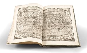
Ortelius / 1570 / Theatrum Orbis Terrarum (1570A - First Edition, First Issue) (Safe 1, 94771) Folio. Contemporary limp vellum (small loss to the tail of the spine; a bit unevenly warped at the edges, possibly a temporary publisher's binding intended to be replaced later). 53 double-page engraved maps (all in first states). Collation: [A, engraved title], AII, B, BII, C, CII, D, DII, 53 double-page engraved maps, a, aII, b, bII, c, cII, d, dII, e, eII, f, fII, g, gII, h, hII, i, iII, k, kII, l, III, m, mII, n, nII, o (not photographed but present), oII. Complete. A handsome, crisp, clean copy. First Edition, First Issue. "A landmark in cartographic publication, for it is the first large modern atlas." (PMM, 91) Exceptional, unsophisticated example of the first state of Abraham Ortelius's Theatrum, one of the most important works in the Western Canon. Ortelius's Theatrum Orbis Terrarum (or "Theater of the World") is widely considered to be the first true modern atlas. When it was published in 1570, the Theatrum was the best available summary of 16th-century cartographic knowledge, covering much of the exploration of the world in the century following the discovery of America. The book's enormous importance in its own time is evidenced by its republication in 36 recorded editions, issued consistently from 1570 to 1612, and inconsistently to 1641. Its continued importance in more recent times has led to at least six facsimile editions being published. The broad appeal of the Theatrum saw demand from many consumers who preferred to read the atlas in their local language. Thus, in addition to Latin, the book was published with text in Dutch, French, German, Italian, Spanish, and English. Ortelius was the artist of all of the maps; he drew them by hand, and those drawings were interpreted into prints by his engravers Frans Hogenberg, Ambrosius Arsenius, and Ferdinand Arsenius. After Ortelius's death in 1598, the copper plates for his atlas passed to his heirs. They, in turn, sold the collection to Jan Baptist Vrients (1522-1612) in 1601. Vrients added new maps and published the atlas until his death in 1612. Vrients's widow then sold the plates to the Moretus brothers, who were the successors of Christoffel Plantijn. The Printing of the First Edition of Ortelius's Theatrum Orbis Terrarum Ortelius's Theatrum has its genesis in the 1550s when the merchant Gilles Hooftman was building a practical map collection. Hooftman had business concerns closely tied to international commerce and political and military events in Europe. Apparently, Hooftman found unrolling large maps to be unwieldy, so it was suggested to him by Jan Radermaker to bind his maps up in book form. When Radermaker befriended Ortelius in 1555, he evidently passed the task off to him. At the time, Italy was the center of global cartographic publishing, as only eight or nine maps had yet been published in the Low Countries. Therefore Ortelius ordered from Rome an "Italian Assembled to Order Atlas" (or "Lafreri School" atlas) with 38 maps. Radermaker recounted this story in a 1603 letter to Jacob Colius Ortelianus, who had wanted to know how his uncle came up with the idea for the Theatrum. (See, Peter van der Krogt, "The Theatrum Orbis Terrarum: The First Atlas?" in Abraham Ortelius and the First Atlas, page 61, 1998) Elsewhere it has been suggested that Gerard Mercator was the progenitor of the idea for the first standardized atlas, but that he held back from competing with Ortelius out of a spirit of friendliness. That being said, because of Mercator's work habits, he would not have been able to produce a work like the Theatrum by 1570, even if he had that in mind. Van der Krogt (Abraham Ortelius., page 65) further explains: Seller Inventory # 94771
Contact seller
Report this item


