
Order Total (1 Item Items):
Shipping Destination:

1756 Seutter (8 results)
Skip to main search results
Search filters
Product Type
- All Product Types
- Books (3)
- Magazines & Periodicals (No further results match this refinement)
- Comics (No further results match this refinement)
- Sheet Music (No further results match this refinement)
- Art, Prints & Posters (No further results match this refinement)
- Photographs (No further results match this refinement)
- Maps (5)
- Manuscripts & Paper Collectibles (No further results match this refinement)
Condition Learn more
- New (No further results match this refinement)
- As New, Fine or Near Fine (3)
- Very Good or Good (1)
- Fair or Poor (No further results match this refinement)
- As Described (4)
Binding
- All Bindings
- Hardcover (No further results match this refinement)
- Softcover (No further results match this refinement)
Collectible Attributes
- First Edition (No further results match this refinement)
- Signed (No further results match this refinement)
- Dust Jacket (No further results match this refinement)
- Seller-Supplied Images (8)
- Not Print on Demand (8)
Language (2)
Price
- Any Price
- Under US$ 25 (No further results match this refinement)
- US$ 25 to US$ 50 (No further results match this refinement)
- Over US$ 50
Free Shipping
- Free Shipping to U.S.A. (No further results match this refinement)
Seller Location
Seller Rating
-

Pianta prospettica di Venezia
Published by Augusta, 1734
Seller: Libreria Antiquaria Linea d'acqua, Venezia, VE, Italy
Seller rating 4 out of 5 stars

Map
Condition: ottimo. Splendida incisione in rame (i. 507 x 588mm) settecentesca raffigurante la citt� di Venezia, impressa su carta forte, finemente inchiostrata e impreziosita da una vivace coloritura coeva. L'esemplare si presenta in ottimo stato di conservazione. La composizione � articolata in due registri distinti ma armonicamente integrati. Nella parte superiore si trova una dettagliata pianta della citt�, derivata dal celebre modello cartografico realizzato da Matth�us Merian e pubblicato nel 1635, mentre il registro inferiore � occupato da due suggestive vedute affiancate di Piazza San Marco di particolare interesse. Nell'angolo superiore sinistro si trova un'iscrizione in lingua italiana "Venetia Potentissima e la pi� Magnifica, Fiorentissima e la pi� ricca Citt� Capitale della Serenissima Republica, edificata sopra 72 le Isole piccole nello Mare Adriatico, tagliata in rame di Matt. Se�ttero, Tagliatore in rame in Aug.", accompagnata dalla corrispondente traduzione tedesca. Analoga impostazione bilingue caratterizza le due vedute di Piazza San Marco. L'apparato decorativo � di notevole qualit�. Nell'angolo superiore sinistro compare la rosa dei venti, mentre in quello opposto � collocato un elegante cartiglio ornato dal Leone di San Marco e sormontato dal corno ducale. (Schulz, 97; Cassini, 73; Moretto, 157.) Cornice originale Atelier Bruno Rizzato, 61,5 x 70,5 cm A splendid eighteenth-century copper engraving (i. 507 x 588mm) depicting the city of Venice, printed on strong paper, finely inked and enhanced by vibrant contemporary hand-colouring. In excellent condition. The composition is arranged in two distinct yet harmoniously integrated registers. The upper section contains a detailed plan of the city derived from the celebrated cartographic model produced by Matth�us Merian and published in 1635, while the lower register is occupied by two attractive side-by-side views of Piazza San Marco, of considerable iconographic interest. In the upper left corner appears an Italian inscription reading: "VENETIA Potentissima e la pi� Magnifica, Fiorentissima e la pi� ricca Citt� Capitale della Serenissima Republica, edificata sopra 72 le Isole piccole nello Mare Adriatico, tagliata in rame di Matt. Se�ttero, Tagliatore in rame in Aug.", accompanied by a corresponding German translation. The same bilingual arrangement characterises the two views of Piazza San Marco. The decorative programme is of notable quality. A compass rose occupies the upper left corner, whilst the opposite corner contains an elegant cartouche adorned with the Lion of Saint Mark and surmounted by the ducal corno. (Schulz, 97; Cassini, 73; Moretto, 157.) Original frame made by Atelier Bruno Rizzato, 61,5 x 70,5 cm.
-
DUCATUS MEDIOLANENSIS CUM ADJACENTIBUS PRINCIPAT. ET DOMINIIS ACCURATISSIME DELINEATUS.
Published by Cartografia, Italia nord occidentale
Seller: Sergio Trippini, Gavirate, VA, Italy
Seller rating 4 out of 5 stars
Carta raffigurante il nord ovest dell'Italia in coloritura coeva.Bibliografia: Motta, p. 11; Arrigoni-Bertarelli, n. 1049; Colombo-Rondanini-GRSD, p. 38, illustr. p. 39.
-
TABULA GEOGRAPHICA IN QUA INTEGRI DUCATUS MEDIOLANENSIS ET MANTUANUS; ITEM DITIO VENETA ET COMITATUS TYROLENSIS, CUM EPISCOPATIBUSTIDENTINO ET BRIXIENSI?
Published by Cartografia, Italia settentrionale - Tirolo
Seller: Sergio Trippini, Gavirate, VA, Italy
Seller rating 4 out of 5 stars
Carta dell'Italia settentrionale con parte dei Grigioni e del Tirolo. L'incisione ripropone la carta del De Fer Les frontieres d'Allemagne et d'Italie del 1701. Vivace coloritura coeva all'acquerello, bel foglio con ampi margini. Bibliografia: Arrigoni-Bertarelli, n. 1050.
-
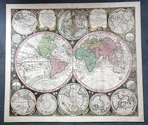
WELTKARTE Originaltitel :"Globi Terr-Aquel Statione variante. " Per coluros tropicorum per ambos Polos.
Published by Augsbourg um, 1735
Seller: Graphica-Antiqua, Stich-Galerie Osvald, St.Gallen, SG, Switzerland
Seller rating 4 out of 5 stars
US$ 1,944.50
US$ 11.59 shipping
Ships from Switzerland to U.S.A.Quantity: 1 available
Add to basketKupferstich, altkoloriert Blattgr�sse 50.5x59.5cm; Bildgr�sse 54.5x62.5cm Mittelfalz, Wasserflecken some waterstaines,
-

Ungarn, Siebenb�rgen, Serbien, Bosnien, Dalmatien u.a. ?Novi�ima et accurati�ima Hungariae cum circumjacentibus Regnis et Principatibus in mappa Geographica Designatio."
Language: German
Published by Seutter, Augsburg, 1741
Map
Condition: Gut bis sehr gut. historische Kupferstich-Landkarte mit sch�nem Altkolorit von Matthaeus Seutter, ((1678-1756) Augsburg um ca. 1741 links unten sch�ne gro�e Titelkartusche mit Wappen und K�nigsportr�t, rechts mit Meilenzeigerkartusche. Seutter war als Kaiserlicher Geograph t�tig, die Karte tr�gt das kaiserliche Privileg, welches 1741 verliehen wurde. Gr��e: 59,5cm x 51cm english: shows Hungary, Transylvania, Serbia, Bosnia, Dalmatia etc. At the left bottom great title cartouche with crest and portrait of the king. At the right side benchmark cartouche. Nice contemporary colour! size: 59,5cm x 51cm.
-

"Africa iuxta Navigationes et Observationes Recentissimas Aucta, Correcta et in Sua Regna et Status Divisa" in lucem edita
Language: German
Published by Augsburg, 1730
Map
Condition: Gut bis sehr gut. AFRIKA seltene, historische, original altkolorierte Kupferstichkarte um 1730 von Matthaeus Seutter, Augsburg (1678-1756) Matth. Seuttero, S. Caes Maj. Geograph Aug. Atlas Novus Sive Tabulae Geographicae Gr��e: 57,5cm x 50cm english: beautiful dark impression of Seutter's map of Africa. It`s a highly detailed and richly engraved map. Seutter's maps are among the most beautifully engraved maps of the period. Atlas Novus Sive Tabulae Geographicae size: 57,5cm x 50cm.
-
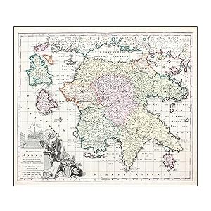
PELOPONNESUS HODIE MOREA AD NORMAM VETERUM ET RECENTIORUM MAPPAR ACCURATISSIME ADORNATA AERI INCISA ET VENALI.
Publication Date: 1727
Seller: LIBRERIA ANTICUARIA MARGARITA DE DIOS, MADRID, M, Spain
Association Member: LANCE LIBRIS
Seller rating 5 out of 5 stars

Map
Sin Encuadernar. Condition: Bien. Materia: Mapa antiguo de la primera mitad del siglo XVIII. Peloponeso. Grecia - Matth�us Seutter. Publicaci�n: Augsburgo, 1727. Descripci�n: Bonito ejemplo de los mapas de Seutter representa el Peloponeso (Grecia) Preciosa cartela con motivos ornamentales y aleg�ricos, titulo y escalas. Medidas: 48 x 58 cm [huella], 53'5 x 60'5 cm [papel]. T�cnica: Grabado calcogr�fico coloreado a mano con acuarela en la �poca. Sin texto en el reverso. Conservaci�n: Buen estado. RES1 Este art�culo necesita permiso de exportaci�n / this item needs an export permit.
-

Ierusalem, cum suburbiis prout tempore Christi floruit.
Publication Date: 1745
Seller: Geographicus Rare Antique Maps, Brooklyn, NY, U.S.A.
Association Member: ABAA ESA ILAB
Seller rating 4 out of 5 stars
Map
Excellent. Few marginal mends not impacting image, else fine with original wash color. Size 18.5 x 22.75 Inches. This is an attractive example of Matthias Seutter's c. 1745 map of Jerusalem following the influential 1584 model of Christian van Adrichem's. For centuries, Adrichem's portrayal of Jerusalem provided the basis for a sort of 'virtual pilgrimage' to the holy sites when actual travel there was, for most, impossible. Seutter's version of the plan here appears in its Lotter imprint of 1756. A Closer Look The Holy City is portrayed in a rectilinear form, divided into three historical zones and listing 244 specific locations, lavishly annotated and keyed to the plan. Named locations are tied to Biblical events from the central Temple of Solomon, to a scene of the Crucifixion, to the prophesied second coming on the Mount of Olives. Stations of the Cross Adrichem's plan was instrumental in codifying elements of Christian veneration of the Holy City, in particular the Stations of the Cross. Catholic practice had, since the Middle Ages, incorporated the reenactment by the faithful of the Via Dolorosa , the route followed by Jesus on the day of Crucifixion. Pilgrims to Jerusalem would follow the route through the Holy Land, but with the expansion of the Turkish Empire such travel was impossible for most. Many Christian cities began to assemble pilgrimage routes locally to allow pilgrims to follow a metaphorical Via Dolorosa without dangerous travel to distant lands. Churches and cathedrals replicated the Stations of the Cross - the different scenes along the Via Dolorosa - in their architecture and decoration. Adrichem's text and plan of Jerusalem provided a model that all could follow, and that the faithful could practice even from the comfort of home, in a sort of 'Pilgrimage of the Mind.' Publication History and Census Seutter's engraving has been sometimes dated as early as 1730, but the practice of tipping newer maps into older atlases has confused the field. For this example, we are adhering to Laor's date of 1745. Lotter's edition was produced in 1756, with only changes to the imprint. The map appears on the market from time to time. We see four examples of the separate Lotter map in institutional collections. References: OCLC 1200494015. Laor, E., Maps of the Holy Land: Cartobibliography of Printed Maps, 1475 - 1900, 1130.

