Order Total (1 Item Items):
Shipping Destination:

Caspar Merian (158 results)
Skip to main search results
Search filters
Product Type
- All Product Types
- Books (113)
- Magazines & Periodicals (No further results match this refinement)
- Comics (No further results match this refinement)
- Sheet Music (No further results match this refinement)
- Art, Prints & Posters (43)
- Photographs (No further results match this refinement)
- Maps (2)
- Manuscripts & Paper Collectibles (No further results match this refinement)
Condition Learn more
- New (25)
- As New, Fine or Near Fine (6)
- Very Good or Good (30)
- Fair or Poor (No further results match this refinement)
- As Described (97)
Binding
Collectible Attributes
Language (3)
Free Shipping
Seller Location
Seller Rating
-
2 komplette Folgen mit jeweils 8 Teilen: Zeitreise durch Berlin / Ansichten einer Stadt. - Enthalten sind historische Stadtpl�ne, Verkehrspl�ne, ein Pharus Plan ( 1944 ) etc. aus den Jahren 1652 bis 1957 nach Johan Gregor Memhard / Johann Friederich Walther / Daniel Friedrich Sotzmann u. a. // Historische Stadtansichten, Panoramen und Luftbildpl�ne 1652 - 1984 nach Caspar Merian, Joh. Bernhardus Schultz, W. Loeillot, Salathe, Adolf Eltzner u. a.
Published by Berlin, Der Tagesspiegel, ohne Jahr ( 2002 / 2003 )., 2003
Seller: Antiquariat Carl Wegner, Berlin, B, Germany
Association Member: GIAQ
Seller rating 5 out of 5 stars

First Edition
Softcover. Zwei komplette Folgen mit jeweils acht historischen einfarbigen und mehrfarbigen Ansichten in verschiedenen Gr��en, teils mehrfach gefaltet auf das Format 29,5 x 21 cm. Sauberer, guter Zustand. Inhalt Zeitreise durch Berlin: Folge 1: Johann Gregor Memhard: Grundri� der Beyden Churf. Residenz St�tte Berlin und C�lln an der Spree, 1652. Folge 2: Johann Friedrich Walther: Plan und Prospect der K�nigl. Preussischen uns Chur. Branndenbg. Haupt- und Residenz-Stadt Berlin, 1737. Folge 3: Daniele Friedrich Sotzmann: Grundriss der K�nigl. Residenzst�dte Berlin, 1792. Folge 4: Berlin und Charlottenburg mit n�chster Umgebung, 1857. Folge 5: Schwieger: Graphische Darstellung der Dichtigkeit der Bev�lkerung von Berlin in den einzelnen Stadtbezirken, 1875. Folge 6: Maraun: Grosser Verkehrs-Plan von Berlin und seinen Vororten, 1896. Folge 7: Pharus-Plan Berlin, Mittel-Ausgabe 1944. Folge 8: Stra�en�bersichtsplan von Berlin 1957. -- Bitte Portokosten au�erhalb EU erfragen! / Please ask for postage costs outside EU! / S ' il vous plait demander des frais de port en dehors de l ' UE! // Bitte beachten Sie auch unsere Fotos! / Please also note our photos! / Veuillez noter nos photos -- Nehmen Sie sich ein gutes Buch mit auf die Sommerwiese. Bei uns werden Sie f�ndig! -- Wir kaufen Ihre werthaltigen B�cher! K02287-320164.
-

Wol-geschliffener Narren-Spiegel : 115 Meriansche Kupfer. hrsg. durch Wahrmund Jocoserius. Neu hrsg. u. mit e. Nachw. vers. von Manfred Lemmer
Language: German
Published by Graz ; Wien ; K�ln : Verl. Styria, 1981
ISBN 10: 3222116539 ISBN 13: 9783222116537
geb. Condition: Gut. 175 S. : 115 Ill. ; 22 cm 3222116539 Sprache: Deutsch.
-
Wol-geschliffener Narren-Spiegel. Worinnen hundert und vierzehen Arten allerley Narren ihr Eben-Bild und ungestaltes Wesen ersehen und sich von ihrer Unsauberkeit vermittelst des klaren Wassers wahrer Weissheit reinigen k�nnen.
Published by Libri Rari, Hannover, 1981
Seller: Versandantiquariat Rainer Kocherscheidt, Velbert, Germany
Association Member: GIAQ
Seller rating 5 out of 5 stars
Pappband. Condition: Sehr gut. Erste Auflage dieser Ausgabe. (228 S.); mit zahlr. SW-Ill.; Nachdruck der Ausgabe 1730 Size: 33,1 cm. Reprint.
-
Antique Print-WESEL-FORTRESS-PLAN-GERMANY-Merian-c.1660
Published by c.1660, 1660
Seller: Pictura Prints, Art & Books, Overasselt, Netherlands
Seller rating 5 out of 5 stars
Art / Print / Poster
'WEESSEL.'Original antique print showing a plan of the fortified city of Wesel, Germany.Made by after an anonymous artist.Medium: Engraving/etching on hand laid (verge) paper.Sheet size: 31.8 x 19.2 cm (12.52 x 7.56 inch). Image size: 25.2 x 17.6 cm. (9.92 x 6.93 inch).WESEL-FORTRESS-PLAN-GERMANY | E24-03BACKGROUND INFORMATIONThis original antique plan originates from 'Topographia Germaniae Inferioris (.)' by C. Merian, published c. 1660.Biography engraver: Caspar Merian (1627-1686) was one of the most important German topographical engravers and publishers in the Baroque period. Condition: good, given age. Paper partly browned, mostly outside of image. Original fold as issued. General age-related toning and/or occasional minor defects from handling. Please study scan carefully.
-
Hardcover. Condition: Very good. Dust Jacket Condition: Very good. In German. Facsimile reproduction of 1655 edition. Edited and illustrated, with engraved title page and plates, by Matthaeus Merian. Dust jacket has mild edge wear with staining and sunning on spine. Binding is tight. Book covers and inside are clean, bright, and unmarked.
-

Topographia Germaniae Inferioris vel Circuli Burgundici das ist Beschreibung und Abbildung der vornehmsten �rter in den Niderl�ndischen XVII Provincien oder Burgundischen Kreise. Hrsg. von Bert van t Hoff. Faksimile der 2. Ausgabe von 1659., 1. Ausgabe 1654. Neue ausgabe.
Published by Kassel und Basel, B�renreiter Verlag, ., 1964
Abb., 283 S., 17 Bl. beige Orig. Pappband mit R�ckenschild, 31 x 20,5 cm, kaum Gebrauchsspuren.
-
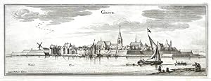
Grave
Published by Merian, Frankfurt am Main, 1659
Seller: Antikvariat Krenek, Prag, Czech Republic
Association Member: ILAB
Seller rating 5 out of 5 stars
Art / Print / Poster
US$ 44.95
US$ 16.87 shipping
Ships from Czech Republic to U.S.A.Quantity: 1 available
Add to basketKein Einband. Condition: Gut bis sehr gut. Grave. "Grave". Orig. copperplate engraving, C. Merian after J. Peeters' drawing, ca. 1650. Published in M. Zeiler's Topographia Germaniae-Inferioris by Merian, 1659. With engraved title and several ships and figures in the foreground. 11,5:31,5 cm (4 1/2 x 12 1/2 inch.). A view of the city of Grave over the Meuse (Maas) river in North Brabant province, the Netherlands.
-

Antique Map-PHILIPPINE-ZEELAND-FORTIFICATION-PLAN-NETHERLANDS-Merian-1660
Publication Date: 1660
Seller: Pictura Prints, Art & Books, Overasselt, Netherlands
Seller rating 5 out of 5 stars
'PHILIPINEN.'Original antique print showing a plan of the fortified city of Philippine in the province of Zeeland, The Netherlands.Made by after an anonymous artist.Medium: Engraving/etching on hand laid (verge) paper.Sheet size: 19.6 x 17.5 cm (7.72 x 6.89 inch). Image size: 17 x 14.9 cm. (6.69 x 5.87 inch).PHILIPPINE-ZEELAND-FORTIFICATION-PLAN-NETHERLANDS | PCOA55-25BACKGROUND INFORMATIONThis original antique plan originates from 'Topographia Germaniae Inferioris (.)' by C. Merian, published c. 1660.Biography engraver: Caspar Merian (1627-1686) was one of the most important German topographical engravers and publishers in the Baroque period. Condition: fair, given age. Brown spots. General age-related toning and/or occasional minor defects from handling. Please study scan carefully.
-

Antique Map-SLUYS-SLUIS-FORTIFICATION-ZEELAND-PLAN-NETHERLANDS-Merian-1660
Publication Date: 1660
Seller: Pictura Prints, Art & Books, Overasselt, Netherlands
Seller rating 5 out of 5 stars
'SLUYS.'Original antique print showing a plan of the fortified city of Sluis in the province of Zeeland, The Netherlands.Made by after an anonymous artist.Medium: Engraving/etching on hand laid (verge) paper.Sheet size: 19.7 x 15 cm (7.76 x 5.91 inch). Image size: 17.2 x 13.1 cm. (6.77 x 5.16 inch).SLUYS-SLUIS-FORTIFICATION-ZEELAND-PLAN-NETHERLANDS | PCOA55-21BACKGROUND INFORMATIONThis original antique plan originates from 'Topographia Germaniae Inferioris (.)' by C. Merian, published c. 1660.Biography engraver: Caspar Merian (1627-1686) was one of the most important German topographical engravers and publishers in the Baroque period. Condition: fair, given age. Paper partly browned with foxing. General age-related toning and/or occasional minor defects from handling. Please study scan carefully.
-
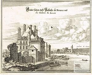
Ander seiten de� Pallasts de Nevers und die Galarie du Louvre. R�ckseite des Palais de Never mit vielen Booten auf der Seine, im Hintergrund die Galerie du Louvre. Kupferstich von Merian aus der "Topographia Galliae" um 1660
Language: French
Published by Frankfurt am Main: Merianische Offizin um, 1660
Seller: historicArt Antiquariat & Kunsthandlung, Wiesbaden-Breckenheim, Germany
Seller rating 5 out of 5 stars
Art / Print / Poster First Edition
1. Original-Kupferstich von Caspar Merian (nicht signiert) auf r�ckseitig unbedrucktem B�tten mit dekorativ abgesetztem Palttenrand, in der Platte eiwei�geh�ht, bildliche Darstellung ca. 13 x 16 cm, die pr�chtigen Kupferstiche von Paris werden im Internet gelegentlich Matth�us Merian dem �lteren zugerechnet, sie wurden jedoch tats�chlich von seinem Sohn Caspar nach dem Tod des Vaters vollendet und in der Topographia Galliae ver�ffentlicht, im Himmel �ber der Seine kleiner Fleck von der Druckerschw�rze, ansonsten gut erhalten, selten 2100 gr.
-

Antique Map-FORT CREVECOEUR-FORTRESS-GREVENCEUR-NETHERLANDS-Merian-1660
Publication Date: 1660
Seller: Pictura Prints, Art & Books, Overasselt, Netherlands
Seller rating 5 out of 5 stars
'GREVENCEUR.'Original antique print showing a plan of Fort Crevecoeur, a Dutch fortress near 's-Hertogenbosch, The Netherlands.Made by after an anonymous artist.Medium: Engraving/etching on hand laid (verge) paper.Sheet size: 20 x 15 cm (7.87 x 5.91 inch). Image size: 17.5 x 13.7 cm. (6.89 x 5.39 inch).FORT-CREVECOEUR-FORTRESS-GREVENCEUR-NETHERLANDS | PCOA55-12BACKGROUND INFORMATIONThis attractive print originates from 'Topographia Germaniae Inferioris (.)' by C. Merian, published c. 1660.Biography engraver: Caspar Merian (1627-1686) was one of the most important German topographical engravers and publishers in the Baroque period. Condition: good, given age. Paper slightly browned. A few crinkles. General age-related toning and/or occasional minor defects from handling. Please study scan carefully.
-

Palais. Ansicht des k�niglichen Palastes auf der Ile de France aus der Vogelperspektive. Kupferstich von Merian aus der "Topographia Galliae" um 1660
Language: French
Published by Frankfurt am Main: Merianische Offizin um, 1660
Seller: historicArt Antiquariat & Kunsthandlung, Wiesbaden-Breckenheim, Germany
Seller rating 5 out of 5 stars
Art / Print / Poster First Edition
1. Original-Kupferstich von Caspar Merian (nicht signiert) auf r�ckseitig unbedrucktem B�tten mit dekorativ abgesetztem Palttenrand, in der Platte eiwei�geh�ht, bildliche Darstellung ca. 11 x 16,5 cm, die pr�chtigen Kupferstiche von Paris werden im Internet gelegentlich Matth�us Merian dem �lteren zugerechnet, sie wurden jedoch tats�chlich von seinem Sohn Caspar nach dem Tod des Vaters vollendet und in der Topographia Galliae ver�ffentlicht, gut erhalten, selten 2100 gr.
-
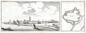
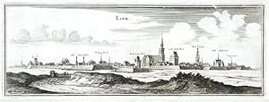
Thiel
Published by Frankfurt am Main, 1659
Seller: Antikvariat Krenek, Prag, Czech Republic
Association Member: ILAB
Seller rating 5 out of 5 stars
US$ 59.92
US$ 16.87 shipping
Ships from Czech Republic to U.S.A.Quantity: 1 available
Add to basketTiel. "Thiel". Orig. copperplate engraving, C. Merian, ca. 1650. Published in M. Zeiler's Topographia Germaniae-Inferioris by Merian, 1659. With engraved title, a ship in the foreground and fortification plan of the city on the right. 12,5:34,5 cm (5 x 13 1/2 inch.). A view and the fortification plan of the city of Tiel in the middle of the Netherlands. - Printed from one plate.
-
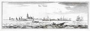
Ter Veer
Published by Frankfurt am Main, 1659
Seller: Antikvariat Krenek, Prag, Czech Republic
Association Member: ILAB
Seller rating 5 out of 5 stars
US$ 59.92
US$ 16.87 shipping
Ships from Czech Republic to U.S.A.Quantity: 1 available
Add to basketVeere. "Ter Veer". Orig. copperplate engraving, C. Merian, ca. 1650. Published in M. Zeiler's Topographia Germaniae-Inferioris by Merian, 1659. With engraved title and several ships in the foreground. 10:31,5 cm (4 x 12 1/2 inch.). A panoramic view of the city of Veere in Zeeland province, the Netherlands.
-
Lier
Published by Frankfurt am Main, 1659
Seller: Antikvariat Krenek, Prag, Czech Republic
Association Member: ILAB
Seller rating 5 out of 5 stars
US$ 59.92
US$ 16.87 shipping
Ships from Czech Republic to U.S.A.Quantity: 1 available
Add to basketLier. "Lier". Orig. copperplate engraving, C. Merian after J. Peeters' drawing, ca. 1650. Published in M. Zeiler's Topographia Germaniae-Inferioris by Merian, 1659. With engraved title. 12:33,5 cm (4 3/4 x 13 1/4 inch.). A panoramic view of the city of Lier in the Belgian province of Antwerp.
-

Elburg
Published by Frankfurt am Main, 1659
Seller: Antikvariat Krenek, Prag, Czech Republic
Association Member: ILAB
Seller rating 5 out of 5 stars
US$ 59.92
US$ 16.87 shipping
Ships from Czech Republic to U.S.A.Quantity: 1 available
Add to basketElburg. "Elburg". Orig. copperplate engraving, C. Merian, ca. 1650. Published in M. Zeiler's Topographia Germaniae-Inferioris by Merian, 1659. With engraved title and a figure in the foreground. 11:34,5 cm (4 1/4 x 13 1/2 inch.). A panoramic view of the city of Elburg in Gelderland province, the Netherlands.
-
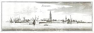
Stavern
Published by Frankfurt am Main, 1659
Seller: Antikvariat Krenek, Prag, Czech Republic
Association Member: ILAB
Seller rating 5 out of 5 stars
US$ 59.92
US$ 16.87 shipping
Ships from Czech Republic to U.S.A.Quantity: 1 available
Add to basketStavoren. "Stavern". Orig. copperplate engraving, C. Merian, ca. 1650. Published in M. Zeiler's Topographia Germaniae-Inferioris by Merian, 1659. With engraved title and several ships in the foreground. 11:33 cm (4 1/4 x 13 inch.). A panoramic view of the city of Stavoren in Friesland province, the Netherlands.
-

WOL-GESCHLIFFENER NARREN-SPIEGEL worinnen hundert u. vierzehen Arten allerley Narren ihr Eben-Bild u. ungestaltes Wesen ersehen u. sich von ihrer Unsauberkeit vermittelst d. klaren Wassers wahrer Weissheit reinigen k�nnen
Language: German
Published by Ed. Libri Rari, Hannover, 1981
Seller: Butterfly Books GmbH & Co. KG, Herzebrock-Clarholz, Germany
Seller rating 5 out of 5 stars
Hardcover. Condition: Gut. Zustand: GUTER Zustand. HC1-486-3/8-00508266 Sprache: Deutsch Gewicht in Gramm: 1173.
-
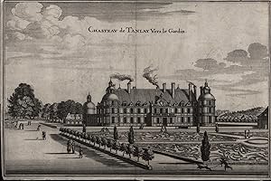
Softcover. Condition: Gut. 18,5x28,0 cm Original-Kupferstich etwas fleckig,einige Knickspuren,sonst GUTES EXEMPLAR.---Sch�ne historische Ansicht des Geb�udes und des Parks, im Park einige Fu�g�nger unterwegs, vorn ein Mann mit Hund. F�r Ihre Zufriedenheit versenden wir mit DHL und ausschlie�lich mit Trackingcode f�r eine sichere Sendungsverfolgung! Weitere Angebote unter antiquariat-kastanienhof , 1 Seiten. nein.
-

Antique Map-FORT CREVECOEUR-FORTRESS-GREVENCEUR-NETHERLANDS-Merian-1660
Publication Date: 1660
Seller: Pictura Prints, Art & Books, Overasselt, Netherlands
Seller rating 5 out of 5 stars
'GREVENCEUR.'Original antique print showing a plan of Fort Crevecoeur, a Dutch fortress near 's-Hertogenbosch, The Netherlands.Made by after an anonymous artist.Medium: Engraving/etching on hand laid (verge) paper.Sheet size: 20 x 15 cm (7.87 x 5.91 inch). Image size: 17.5 x 13.7 cm. (6.89 x 5.39 inch).FORT-CREVECOEUR-FORTRESS-GREVENCEUR-NETHERLANDS | PCOA55-12BACKGROUND INFORMATIONThis attractive print originates from 'Topographia Germaniae Inferioris (.)' by C. Merian, published c. 1660.Biography engraver: Caspar Merian (1627-1686) was one of the most important German topographical engravers and publishers in the Baroque period. Condition: good, given age. Small brown spot in the Maas river. General age-related toning and/or occasional minor defects from handling. Please study scan carefully.
-

Antique Map-ELBURG-PLAN-GELDERLAND-NETHERLANDS-Merian-1660
Publication Date: 1660
Seller: Pictura Prints, Art & Books, Overasselt, Netherlands
Seller rating 5 out of 5 stars
'ELBURG.'Original antique print showing a plan of the fortified city of Elburg, The Netherlands. With compass rose and scale.Made by after an anonymous artist.Medium: Engraving/etching on hand laid (verge) paper.Sheet size: 20 x 16 cm (7.87 x 6.3 inch). Image size: 17.2 x 12.9 cm. (6.77 x 5.08 inch).ELBURG-PLAN-GELDERLAND-NETHERLANDS | PCOA55-18BACKGROUND INFORMATIONThis original antique plan originates from 'Topographia Germaniae Inferioris (.)' by C. Merian, published c. 1660.Biography engraver: Caspar Merian (1627-1686) was one of the most important German topographical engravers and publishers in the Baroque period. Condition: very good, given age. A few mnor crinkles. General age-related toning and/or occasional minor defects from handling. Please study scan carefully.
-

Antique Map-FORT CREVECOEUR-FORTRESS-GREVENCEUR-NETHERLANDS-Merian-1660
Publication Date: 1660
Seller: Pictura Prints, Art & Books, Overasselt, Netherlands
Seller rating 5 out of 5 stars
'GREVENCEUR.'Original antique print showing a plan of Fort Crevecoeur, a Dutch fortress near 's-Hertogenbosch, The Netherlands.Made by after an anonymous artist.Medium: Engraving/etching on hand laid (verge) paper.Sheet size: 20.3 x 16 cm (7.99 x 6.3 inch). Image size: 17.5 x 13.7 cm. (6.89 x 5.39 inch).FORT-CREVECOEUR-FORTRESS-GREVENCEUR-NETHERLANDS | PCOA55-12BACKGROUND INFORMATIONThis attractive print originates from 'Topographia Germaniae Inferioris (.)' by C. Merian, published c. 1660.Biography engraver: Caspar Merian (1627-1686) was one of the most important German topographical engravers and publishers in the Baroque period. Condition: good, given age. Vertical fold. General age-related toning and/or occasional minor defects from handling. Please study scan carefully.
-

Antique Print-BREEVOORT-BREDEVOORT-FORTIFICATION-NETHERLANDS-Merian-1660
Publication Date: 1660
Seller: Pictura Prints, Art & Books, Overasselt, Netherlands
Seller rating 5 out of 5 stars
Art / Print / Poster
'BREEVOORT.'Original antique print showing the fortification and castle of Bredevoort in The Netherlands.Made by after an anonymous artist.Medium: Engraving/etching on hand laid (verge) paper.Sheet size: 18 x 24.2 cm (7.09 x 9.53 inch). Image size: 14.7 x 17.1 cm. (5.79 x 6.73 inch).BREEVOORT-BREDEVOORT-FORTIFICATION-NETHERLANDS | PCOA55-09BACKGROUND INFORMATIONThis attractive print originates from 'Topographia Germaniae Inferioris (.)' by C. Merian, published c. 1660.Biography engraver: Caspar Merian (1627-1686) was one of the most important German topographical engravers and publishers in the Baroque period. Condition: good, given age. A few brown spots. General age-related toning and/or occasional minor defects from handling. Please study scan carefully.
-

Antique Print-BIRVLIET-BIERVLIET-ZEELAND-FORTIFICATION-NETHERLANDS-Merian-1660
Publication Date: 1660
Seller: Pictura Prints, Art & Books, Overasselt, Netherlands
Seller rating 5 out of 5 stars
Art / Print / Poster
'BIRVLIET.'Original antique print showing the fortification of Biervliet in the province of Zeeland, The Netherlands.Made by after an anonymous artist.Medium: Engraving/etching on hand laid (verge) paper.Sheet size: 20 x 15 cm (7.87 x 5.91 inch). Image size: 17.5 x 13 cm. (6.89 x 5.12 inch).BIRVLIET-BIERVLIET-ZEELAND-FORTIFICATION-NETHERLANDS | PCOA55-09BACKGROUND INFORMATIONThis attractive print originates from 'Topographia Germaniae Inferioris (.)' by C. Merian, published c. 1660.Biography engraver: Caspar Merian (1627-1686) was one of the most important German topographical engravers and publishers in the Baroque period. Condition: very good, given age. General age-related toning and/or occasional minor defects from handling. Please study scan carefully.
-
![Seller image for Flecken Gittelde [Gittelde �ber Seesen]. Gesamtansicht, unten links mit einer Kartusche. Orig. Kupferstich unter Passepartou im passenden Holzrahmen nach Conrad Buno. Einzelblatt aus: Matth�us Merian d.�., Topographia und eigentlichen Beschreibung der vornembsten St�te Schl�sser auch anderer Pl�tze und �rter in denen Hertzogthumer Braunschweig und L�neburg. Plattengr��e ca. 35 x 23 cm (ein kleines L�chlein, das Blatt unter dem Passepartout leicht verrutscht, sonst gutes und saubrees Exemplar in einem kr�ftigen Abdruck). for sale by Antiquariat Dr. Lorenz Kristen](https://pictures.abebooks.com/inventory/md/md16679244505.jpg)
Flecken Gittelde [Gittelde �ber Seesen]. Gesamtansicht, unten links mit einer Kartusche. Orig. Kupferstich unter Passepartou im passenden Holzrahmen nach Conrad Buno. Einzelblatt aus: Matth�us Merian d.�., Topographia und eigentlichen Beschreibung der vornembsten St�te Schl�sser auch anderer Pl�tze und �rter in denen Hertzogthumer Braunschweig und L�neburg. Plattengr��e ca. 35 x 23 cm (ein kleines L�chlein, das Blatt unter dem Passepartout leicht verrutscht, sonst gutes und saubrees Exemplar in einem kr�ftigen Abdruck).
Language: German
Published by Frankfurt am Main: Matth�us Merian, 1654
Seller: Antiquariat Dr. Lorenz Kristen, Berlin, Germany
Seller rating 5 out of 5 stars
Art / Print / Poster
[Hinweis: Verkauft wird die Karte, der leicht beriebene Holzrahmen gilt nur als Transportschutz] ----------------------------------------------------------------------------------- ------------------------------------------------------------ ------------------------------------------------------------ ----------------- BITTE BEACHTEN: Auf Grund der absurden und irrsinnig teuren staatlichen Regelungen f�r die Entsorgung der Versandpappen in den nachfolgenden L�ndern, kann ich leider nicht mehr liefern nach: �sterreich, Griechenland, Polen. Kunden in �STERREICH k�nnen sich aber an die einheimische Post wenden, dort unter Alles Post Deutschland. --- PLEASE NOTE: Due to the absurd and insanely expensive government regulations for the disposal of shipping cartons in the following countries, I can unfortunately no longer deliver to: Austria, Greece, Poland. However, customers in AUSTRIA can contact their local post office, there under Alles Post Deutschland.
-

Kein Einband. Condition: Gut. Kupferstich auf B�tten, auf Karton montiert. 14,2 x 38,5 cm (Einfassungslinie). 16 x 40,4 cm (Blatt). vertikale Knickfalten, leicht braunfleckig. Druckgrafik.
-

Louvre in Grundt.
Published by [Frankfurt: Caspar Merian, circa 1675]., 1675
Seller: Wittenborn Art Books, San Francisco, CA, U.S.A.
Seller rating 5 out of 5 stars
Art / Print / Poster
Condition: Good. Engraving. 14.5 x 18.5 cm. (sheet). Very Good, center fold in sheet, short tear.
-

Antique Map-THOLEN-PLAN-FORTIFICATION-ZEELAND-NETHERLANDS-Merian-1660
Publication Date: 1660
Seller: Pictura Prints, Art & Books, Overasselt, Netherlands
Seller rating 5 out of 5 stars
'TER TOLEN.'Original antique print showing a plan of the fortification of Tholen in the province of Zeeland, The Netherlands.Made by after an anonymous artist.Medium: Engraving/etching on hand laid (verge) paper.Sheet size: 17.7 x 24.8 cm (6.97 x 9.76 inch). Image size: 13.3 x 17.4 cm. (5.24 x 6.85 inch).THOLEN-PLAN-FORTIFICATION-ZEELAND-NETHERLANDS | PCOA55-19BACKGROUND INFORMATIONThis original antique plan originates from 'Topographia Germaniae Inferioris (.)' by C. Merian, published c. 1660.Biography engraver: Caspar Merian (1627-1686) was one of the most important German topographical engravers and publishers in the Baroque period. Condition: very good, given age. General age-related toning and/or occasional minor defects from handling. Please study scan carefully.
-

Antique Map-ZIERIKZEE-PLAN-FORTIFICATION-NETHERLANDS-Merian-1660
Publication Date: 1660
Seller: Pictura Prints, Art & Books, Overasselt, Netherlands
Seller rating 5 out of 5 stars
'ZURICKZEE.'Original antique print showing a plan of the fortified city of Zierikzee in the province of Zeeland, The Netherlands.Made by after an anonymous artist.Medium: Engraving/etching on hand laid (verge) paper.Sheet size: 19 x 25 cm (7.48 x 9.84 inch). Image size: 14 x 17.5 cm. (5.51 x 6.89 inch).ZIERIKZEE-PLAN-FORTIFICATION-NETHERLANDS | PCOA55-27BACKGROUND INFORMATIONThis original antique plan originates from 'Topographia Germaniae Inferioris (.)' by C. Merian, published c. 1660.Biography engraver: Caspar Merian (1627-1686) was one of the most important German topographical engravers and publishers in the Baroque period. Condition: good, given age. Original printing crease far left. General age-related toning and/or occasional minor defects from handling. Please study scan carefully.
-

Antique Map-ZALTBOMMEL-PLAN-FORTIFICATION-NETHERLANDS-Merian-1660
Publication Date: 1660
Seller: Pictura Prints, Art & Books, Overasselt, Netherlands
Seller rating 5 out of 5 stars
'BOMMEL.'Original antique print showing a plan of the fortified city of Zaltbommel in the province of Gelderland, The Netherlands.Made by after an anonymous artist.Medium: Engraving/etching on hand laid (verge) paper.Sheet size: 15.8 x 20 cm (6.22 x 7.87 inch). Image size: 13 x 17.2 cm. (5.12 x 6.77 inch).ZALTBOMMEL-PLAN-FORTIFICATION-NETHERLANDS | PCOA55-27BACKGROUND INFORMATIONThis original antique plan originates from 'Topographia Germaniae Inferioris (.)' by C. Merian, published c. 1660.Biography engraver: Caspar Merian (1627-1686) was one of the most important German topographical engravers and publishers in the Baroque period. Condition: good, given age. A few minor foxing spots. General age-related toning and/or occasional minor defects from handling. Please study scan carefully.