

Order Total (1 Item Items):
Shipping Destination:

Aleuten (3 results)
Author:
aleuten
Refine with Advanced Search
Skip to main search results
Search filters
Product Type
- All Product Types
- Books (1)
- Magazines & Periodicals (No further results match this refinement)
- Comics (No further results match this refinement)
- Sheet Music (No further results match this refinement)
- Art, Prints & Posters (1)
- Photographs (No further results match this refinement)
- Maps (1)
- Manuscripts & Paper Collectibles (No further results match this refinement)
Condition Learn more
- New (No further results match this refinement)
- As New, Fine or Near Fine (No further results match this refinement)
- Very Good or Good (No further results match this refinement)
- Fair or Poor (No further results match this refinement)
- As Described (3)
Binding
- All Bindings
- Hardcover (No further results match this refinement)
- Softcover (No further results match this refinement)
Collectible Attributes
- First Edition (No further results match this refinement)
- Signed (No further results match this refinement)
- Dust Jacket (No further results match this refinement)
- Seller-Supplied Images (3)
- Not Print on Demand (3)
Language (2)
Price
- Any Price
- Under US$ 25 (No further results match this refinement)
- US$ 25 to US$ 50
- Over US$ 50
Free Shipping
- Free Shipping to U.S.A. (No further results match this refinement)
Seller Location
Seller Rating
-
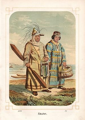
Aleuten. Ein Paar in landestypischer Tracht / Kleidung.
Seller: Antiquariat Martin Barbian & Grund GbR, Saarbruecken, Germany
Seller rating 5 out of 5 stars

Art / Print / Poster
Farblithographie bei Gatternicht in Stuttgart, 1876, 15x10,5 cm *Die Aleuten (Aleutian Islands) sind eine Inselkette zwischen Nordamerika und Asien am Südrand des nordpazifischen Beringmeers. Die größtenteils zum US-Bundesstaat Alaska gehörende Inselgruppe erstreckt sich bogenförmig am Südrand des nordpazifischen Beringmeers von der Alaska-Halbinsel über rund 1750 Kilometer Länge in Richtung Westen bis zu den russischen Kommandeurinseln.
-
"On the Condition of the Furseal Fisheries of Alaska.".
Published by Washington, Government Printing Office, 1896., 1896
Seller: Antiquariat MEINDL & SULZMANN OG, Wien - Vienna, Austria
Seller rating 5 out of 5 stars
Unterschiedliche Größen (Faltspuren). I) "The "Reef" and "Garbotch" Land Angles taken May 22d and June 7th, 1890 . Drawn by Henry W. Elliott and Chas. J. Goff . Area and Position of the Breeding Seals." (Blattgröße ca. 42 x 33 cm. Bildausschnitt ca. 38 x 31 cm).- II) "English Bay. The Zapadnie Rookeries, St. Paul's Island. Land Angles surveyed and drawn . 1890, by Henry W. Elliott and Chas. J. Goff." (Blattgröße ca. 38 x 47 cm. Bildausschnitt ca. 33 x 43 cm).- III) The Polavina Rookeries, St. Paul's Island. Land angles Surveyed and Drawn . 1890 by Henry W. Elliott & Chas. J. Goff" (Blattgröße ca. 44 x 33 cm. Bildausschnitt ca. 37 x 30 cm).- IV) "Novastoshnah Rookery, St. Paul's Island. Land Angles Surveyed and Drawn . 1890 by Henry W. Elliott and Chas. J. Goff" (Blattgröße ca. 36 x 27,5 cm. Bildausschnitt ca. 30 x 26,5 cm).- V) "The "Lagoon" Rookery, with its Surroundings of the Killing Grounds, Landings and Village of St. Paul's Island. Land Angles Surveyed and Drawn . 1890 by Henry W. Elliott and Chas. J. Goff" (Blattgröße ca. 30 x 20,5 cm. Bildausschnitt ca. 25 x 19 cm).- VI) "Tolstoi Rookery, St. Paul's Island. Land Angles surveyed and drawn . Area and Position of the Breeding Seals . 1890, by Henry W. Elliott and Chas. J. Goff" (Blattgröße ca. 30 x 20,5 cm. Bildausschnitt ca. 25 x 19 cm).- VII) "Land Angles of "Lukannon" and "Ketavie" . Seal Rookeries . 1890, by Henry W. Elliott and Charles J. Goff" (Blattgröße ca. 30 x 20,5 cm. Bildausschnitt ca. 25 x 19 cm).- VIII) "North Rookery, St. George Island. Surveyed and Drawn, July 19th, 1890, by Henry W. Elliott" (Blattgröße ca. 22,5 x 30 cm. Bildausschnitt ca. 12 x 25 cm).- IX) "Great Eastern Rookery, St. George Island. Surveyed and Drawn . 1890 by Henry W. Elliott" (Blattgröße ca. 14 x 22,5 cm. Bildausschnitt ca. 11 x 19 cm).- X) "Little East Rookery, St. George Island. Surveyed and Drawn . 1890 by Henry W. Elliott" (Blattgröße ca. 22,5 x 14 cm. Bildausschnitt ca. 9 x 11,5 cm).- XI) "Starry Arteel" Rookery, St. George Island. Surveyed and Drawn . 1890 by Henry W. Elliott" (Blattgröße ca. 14 x 22,5 cm. Bildausschnitt ca. 11 x 19 cm).- XII) "Zapadnie Rookery, St. George Island. Surveyed and Drawn . 1890 by Henry W. Elliott" (Blattgröße ca. 22,5 x 13,5 cm. Bildausschnitt ca. 13,5 x 11 cm).- XIII) "Hauling Grounds at South West Point. St. Paul's Isd. Pribylov Grp. Season of 1872." (Blattgröße ca. 15 x 22,5 cm. Bildausschnitt ca. 11 x 16 cm).- XIV) "St. George Island; Pribylov Group. Showing the Area and Position of the Fur Seal Breeding . Surveyed . 1873-74, and August 1890, and drawn August 2nd, 1890. By Henry W. Elliott" (Blattgröße ca. 22,5 x 34,5 cm. Bildausschnitt ca. 20 x 31).- XV) "St. Paul Island. A revised, General Map of St. Paul Island; Pribylov Group . Surveyed and Drawn during the Seasons of 1872, 1874 and 1890 by Henry W. Elliott" (Blattgröße ca. 37 x 33 cm. Bildausschnitt ca. 32,5 x 31 cm).
-

Lithografie- Karte, v. H. Ode aus Vandermaelen, "Asie. Iles Aleutiennes. No.39".
Language: German
Seller: Antiquariat Clemens Paulusch GmbH, Berlin, Germany
Seller rating 5 out of 5 stars
Map
mit altem Grenzkolorit, um 1827, 48 x 62 Zeigt die östlichen Aleuten in Alaska, zwischen Amatignak Island und Unalaska Island mit Routen von Entdeckern.

