

Order Total (1 Item Items):
Shipping Destination:

Allied Operational Maps (2 results)
Skip to main search results
Search filters
Product Type
- All Product Types
- Books (1)
- Magazines & Periodicals (No further results match this refinement)
- Comics (No further results match this refinement)
- Sheet Music (No further results match this refinement)
- Art, Prints & Posters (1)
- Photographs (No further results match this refinement)
- Maps (No further results match this refinement)
- Manuscripts & Paper Collectibles (No further results match this refinement)
Condition Learn more
- New (No further results match this refinement)
- As New, Fine or Near Fine (No further results match this refinement)
- Very Good or Good (No further results match this refinement)
- Fair or Poor (No further results match this refinement)
- As Described (2)
Binding
- All Bindings
- Hardcover (No further results match this refinement)
- Softcover (No further results match this refinement)
Collectible Attributes
- First Edition (1)
- Signed (No further results match this refinement)
- Dust Jacket (No further results match this refinement)
- Seller-Supplied Images (1)
- Not Print on Demand (2)
Language (1)
Price
- Any Price
- Under US$ 25 (No further results match this refinement)
- US$ 25 to US$ 50 (No further results match this refinement)
- Over US$ 50
Free Shipping
- Free Shipping to U.S.A. (No further results match this refinement)
Seller Location
Seller Rating
-
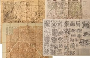
Allied Operational Maps of Germany and France, 1943-1944: A U.S. Soldier's Archive Used in the Liberation of Europe, materially linking frontline navigation, aerial bombardment, liberation campaigns, and the geopolitical reconfiguration of Europe under the expanding Soviet Bloc
Publication Date: 1943
Seller: Max Rambod Inc, Woodland Hills, CA, U.S.A.
Association Member: ABAA ILAB PADA
Seller rating 5 out of 5 stars

Art / Print / Poster First Edition
First Edition. Archive of nine large original World War II maps used by a United States Army soldier in the European Theater of Operations during the Allied liberation of Western Europe. Lithographed military maps, variously issued by U.S. Army and War Office agencies, 1943-1944. Large formats ranging from approximately 19" x 24" to 42" x 34". These maps document the cartographic infrastructure of Allied ground and air operations in the climactic campaigns of 1944-1945. The German sheets-many designated for "Army/Air" or restricted War and Navy Department use-reflect the intensive aerial reconnaissance, bombing coordination, and mechanized advance into the industrial and administrative heartland of the Third Reich. Cities such as Berlin, Magdeburg, Kassel, and Düsseldorf were central to armaments production, rail networks, and military command, making accurate and rapidly updated mapping indispensable. The Paris map corresponds to the Allied advance culminating in the Liberation of Paris in August 1944, marking the symbolic reclamation of a major European capital from Nazi control. Several sheets note reliance on prewar German cartography (1938 editions) supplemented by wartime intelligence, underscoring how Allied forces repurposed and revised enemy geographic data for invasion and occupation planning. Crucially, these maps also capture a political geography that was almost immediately transformed by postwar settlement and Soviet expansion into Central and Eastern Europe. Within two years of their issue, Germany was divided into occupation zones and, by 1949, into separate states aligned with Western and Soviet blocs. Cities such as Berlin, Halle (Saale), Magdeburg, and Wernigerode fell within the Soviet zone and subsequently the German Democratic Republic, fundamentally altering administrative boundaries, transportation networks, and the ideological framing of space. Cartographic production in these regions shifted accordingly, with new editions reflecting socialist state structures and restricted internal mapping policies characteristic of the emerging Eastern Bloc. Thus, these 1943-1944 sheets preserve a transitional moment: Nazi Germany still territorially intact on paper, yet already subjected to Allied military penetration, and poised on the brink of partition. As artifacts carried by an American soldier, they embody both the tactical prosecution of total war and the immediate redrawing of Europe into Cold War spheres of influence. The archive includes operational maps of Magdeburg (Sheet M.53, 1:250,000, "First Edition," 1943, with manuscript annotation), Kassel (Sheet L52, "Emergency Road Map," First Edition, color, based on 1938 mapping with wartime intelligence updates), Düsseldorf (Sheet K52, similar issue, with fading, highlighting, and manuscript marks), Hanover (Sheet L53, 1943), Berlin (Sheet N53, "Army/Air," 1943), Halle (Saale) (Sheet M52, marked "War and Navy Department Agencies only. Not for sale or distribution," 1943), Wernigerode (Sheet 4130, First Edition, War Office, 1944), Jülich (G.S.G.S. No. 4507, War Office, 1944, 35" x 30"), and a large U.S.-issued map of Paris (42" x 34", 1944). All were retained by the soldier following his service. Very good overall, with expected wartime folds and handling; several sheets with manuscript annotations, highlighting, fading, or moderate water exposure (notably Wernigerode, stiffened from dampness); no major losses observed. A substantial and research-rich archive of original Allied operational maps, materially linking frontline navigation, aerial bombardment, liberation campaigns, and the swift geopolitical reconfiguration of Germany and Europe under the expanding Soviet Eastern Bloc.
-

Archive of 6 original Allied Operational Maps, Document both the liberation of Central Europe by US Forces and the swift geopolitical transformation that consigned much of that terrain to the Soviet Eastern Bloc
Publication Date: 1939
Seller: Max Rambod Inc, Woodland Hills, CA, U.S.A.
Association Member: ABAA ILAB PADA
Seller rating 5 out of 5 stars
Archive of six large original World War II-era maps used by a United States Army soldier in the European Theater of Operations during the Allied liberation of Europe. Lithographed maps, various issuers, 1938-1939 (wartime use 1944-1945). Beyond their immediate tactical utility, these maps occupy a pivotal geopolitical moment. The Czech sheets document territories liberated by American forces in May 1945, particularly around Plze?, which marked the effective western limit of U.S. advance before demarcation lines were fixed with Soviet forces. Within months, these same regions fell firmly within the Soviet sphere of influence, formalized through postwar agreements and culminating in the 1948 Communist coup in Czechoslovakia. Cartographically, borders, administrative divisions, and place names shifted to reflect the new socialist state, while subsequent Eastern Bloc map production emphasized different political geographies aligned with Moscow. Thus, these pre-Communist and German-printed sheets capture a fleeting interstice: cities momentarily under American military administration before incorporation into the Soviet Eastern Bloc. The 1938 promotional map of Czechoslovakia preserves the nation's pre-Munich territorial identity, prior to its partition under Nazi pressure, while the 1939 Hamburg map reflects the industrial heartland of the Third Reich before Allied devastation and Germany's eventual division into East and West. In this sense, the archive charts not only wartime movement but the rapid redrawing of Europe's political landscape-where American operational cartography was almost immediately superseded by Cold War boundary-making. Sizes range from 19" x 24" to 34" x 22". The archive comprises detailed city and regional maps of western Czechoslovakia-M?sto Teplá (19" x 24"), Plze? (Sheet 4151, 24" x 19", black and white with green overlay), Hor?ovský Týn (Sheet 4150, 24" x 19"), and Kralovice (Sheet 4051)-together with a large 1938 promotional map of Czechoslovakia (34" x 22") and a 1939 German-printed map of Hamburg (28" x 24"). All are original period printings retained by the soldier following his service. Good overall, with expected wartime folds, creasing, and moderate wrinkling from field use and storage; no significant losses observed. A rare and materially resonant survival of Allied operational maps that document both the liberation of Central Europe and the swift geopolitical transformation that consigned much of that terrain to the Soviet Eastern Bloc, rendering these sheets artifacts of a brief and transitional military presence.

