Anderson Map (28 results)
- Hardcover
Seller: THE OLD LIBRARY SHOP, Bethlehem, PA, U.S.A.THE OLD LIBRARY SHOP
Contact seller5-star sellerCondition: Used - Fine
US$ 5.50
US$ 6.00 shippingShips within U.S.A.Quantity: 1 available
Hard Cover. Condition: fine. Dust Jacket Condition: fine. 1st ptg. 257 pages. Tim Zeltner, dj il & Tim Hall, map & family tree (illustrator). Hardcover (dj).

Travelers' Tales
Marybeth Bond (Editor); Dervla Murphy (Introduction); Jo Broyles Yohay, Jan Haag, Alison Darosa, et al. (Contributors)
Language: English
Published by Travelers' Tales, Inc., San Francisco, CA, 1997
- Softcover
Seller: gearbooks, The Bronx, NY, U.S.A.gearbooks
Contact seller5-star sellerCondition: Used - Very good
US$ 15.00
US$ 5.99 shippingShips within U.S.A.Quantity: 1 available
Trade Paperback. Condition: Very Good. 4th Printing, February 1997. 450 pp. Solidly bound copy with moderate external wear, crisp pages and clean text. Previous owner's name inscribed on inside of front cover. Small stain on first three pages. Judy Anderson (Cover Design); Janet Fullwood (Cover Photo); Keith Granger (Map) (illus…trator).
 More images
Language: English
Published by Bantam Spectra Book, New York, New York, U.S.A., 2000
Series: Prelude to Dune, Book 1 of 3. Book 1 of 3 - Prelude to Dune
- Softcover
Seller: Bargain Finders of Colorado, Simla, CO, U.S.A.Bargain Finders of Colorado
Contact seller4-star sellerCondition: Used - Near fine
US$ 16.95
US$ 5.00 shippingShips within U.S.A.Quantity: 2 available
Mass Market Paperback. Condition: Near Fine. 3rd Edition. The first book in a trilogy of prequels to Dune. Capturing all the complexity and grand themes of the original, this novel weaves a new tapestry of betrayal, passion, and destiny into a saga that expands the tale written by Frank Herbert more than 30 years ago. Beginning…with the old Emperor Elrood IX still on the throne, the authors introduce the pivotal characters, alliances, base treacheries, and bright hopes that form the foundation of "Dune". Unabridged reprint. xviii + 684 Almost new paperbacks. No Marks in text, minor reading creases. Never individually sold. Copyrights 1999, 2000. From Bantam Mass Market Edition, August, 2000. Full printline indicates this copy is from 1st printing. Printed in U.S.A. ISBN: 0-553-58027-2. LCCN: 99-17726. MSR = $6.99. Youll, Stephen (Cover Art) ;Cain, David (Map Designs) (illustrator).
Language: English
Published by Univiversity of New Mexico Press, Albuquerque, New Mexico, 1996
- Softcover
- First Edition
Seller: WONDERFUL BOOKS BY MAIL, CHICO-CA, CA, U.S.A.WONDERFUL BOOKS BY MAIL
Contact seller5-star sellerCondition: Used - Very good
US$ 22.00
US$ 3.75 shippingShips within U.S.A.Quantity: 1 available
paperback. Condition: Very Good. First Edition" Thus. VERY GOOD Condition PAPERBACK, clean, solid,bright.A MAGNIFICENT BOOK. ; white spine & cover titles on deep brown paper covers.(OBLONG).SHOWING LARGE GRINDING STONE WITH SCENIC VIEW AS COVER PHOTO. ; 168 pages; extraordinary first-person accounts of one of the most journeys e…ver undertaken-the OverlandTrail to California and Oregon 1840s-1870 . pictures of pioneer graveyards and views of sites long paved over, their history resonant only in the extant diaries of those who made the journey. Extracts from such diaries and anecdotes about the places in the photos make an excellent supplement to the photographic document. Illustrated by Photos,drawings,map (illustrator).

Published by United States Department Of The Interior Fish And Wildlife SErvice
Seller: Terrace Horticultural Books, St. Paul, MN, U.S.A.Terrace Horticultural Books
Contact seller4-star sellerStapleBound. Condition: Very Good, Frank McKinney Copy. Copyright Date: 1974 Sm Quarto, , PP.73, Fish And Wildlife Service Resource Publication 115. Text Figures, Map (illustrator).

- Hardcover
- First Edition
Seller: Ground Zero Books, Ltd., Silver Spring, MD, U.S.A.Ground Zero Books, Ltd.
Contact seller5-star sellerCondition: Used
US$ 25.00
US$ 5.00 shippingShips within U.S.A.Quantity: 1 available
Hardcover. 384 p. Endpaper maps. Illustrations. Index. From Wikipedia: "Scott Anderson is an American novelist, journalist and a veteran war correspondent. He wrote novels Triage, Moonlight Hotel, The Man Who tried to Save the World, and War Zones. He is a frequent contributor to for the New York Times Magazine, GQ, Esquire, Men… s Journal, Vanity Fair and other publications. Anderson grew up in East Asia, primarily in Taiwan and Korea, where his father was an agricultural advisor for the American government. His career began with a 1994 article in Harper's Magazine on the Northern Ireland events. The 2007 movie The Hunting Party starring Richard Gere and Terrence Howard, is partially based on his work in Bosnia. The 2009 drama film Triage starring Colin Farrell, Paz Vega and Sir Christopher Lee, is based on his novel. Anderson currently lives in Brooklyn, New York. In a September 2009 issue of GQ, Anderson wrote an article on Putin's role in the Russian apartment bombings, based in part on his interviews with Mikhail Trepashkin. The journal owner, Conde Nast, then took extreme measures to prevent an article by Anderson from appearing in the Russian media, both physically and in translation. According to the NPR, Anderson was asked not to syndicate the article to any Russian publications, but told GQ he would refuse the request." Also from Wikipedia: "Frederick C. Cuny (born November 14, 1944 in New Haven, Connecticut) was an American disaster relief specialist who was active in many humanitarian projects around the world from 1969 until his forced disappearance in Chechnya in 1995.In 1952 Cuny moved with his family to Texas. He had a passion for flying and hoped to become a fighter pilot. He studied engineering at Texas A&M University, specializing in problems in developing countries, and urban planning at the University of Houston. Unable to pass his language requirements, Cuny could not go on to Officers' Candidate School, thus ending his dream of life as an officer in the military. However, he became increasingly involved in causes such as the problems of local Mexican migrant workers. Cuny became an accomplished civil engineer, working on large construction projects such as a radar installation at Dallas-Fort Worth International Airport. At some point he became dissatisfied and decided to become a disaster relief specialist who used his training in engineering to do humanitarian work. Cuny was hired by organizations such as the United Nations and private foundations to design and carry out relief plans. Cuny was able to maintain the autonomy to devise solutions his way and became increasingly active as a policy adviser. Cuny's overriding goal was to institute a radical restructuring of the way the disaster relief system operated throughout the world. In 1971 he founded the non-profit Intertect Relief and Reconstruction Corp. of Dallas, Texas, a relief mission technical assistance and training company. This company became the major disaster relief agency, Interworks. Cuny also founded the Center for the Study of Societies in Crisis which became known as the Cuny Center after his death. He worked in countries such as Biafra, Guatemala, Ethiopia, Iraq, Somalia, and Bosnia. At the end of his life he was working closely with George Soros' Open Society Institute, and was instrumental in the early stages of founding the International Crisis Group, which seeks to institutionalize the knowledge base of relief experts. Cuny was named a MacArthur Fellow in 1995, but disappeared before he could officially receive his award. In April 1995, Cuny and his team of two Russian Red Cross doctors and an interpreter disappeared in Chechnya while seeking to negotiate a ceasefire. Cuny's family believes that although they were in contact with the Chechen forces under Dzhokhar Dudayev who were meant to pass them on for safe keeping, they were arrested and executed under the orders of Rizvan Elbiev (Elbiyev), a local Chechen rebel counterintelligence command. Ward, Jeffrey L. (Map) (illustrator).
Published by Dept. of Educaiton, Victoria BC, 1925
- Hardcover
- First Edition
Seller: Vashon Island Books, Vashon, WA, U.S.A.Vashon Island Books
Contact seller5-star sellerCondition: Used - Good
US$ 14.95
US$ 5.50 shippingShips within U.S.A.Quantity: 1 available
Hardcover. Condition: Good. No Dust Jacket. First Edition. In black cloth with green titling, 8vo, 165pp. Illustrated. (shelfwear, rubbing and soiling to cloth and spine, browning to edges and endpapers, name in ink). Size: 8vo - over 7¾" - 9¾". B/w Illustraions and Fold Out Map (illustrator). Book.
 More images
Language: English
Published by Bantam Books, New York, NY U.S.A., 1999
Series: Prelude to Dune, Book 1 of 3. Book 1 of 3 - Prelude to Dune
- Softcover
Seller: Bargain Finders of Colorado, Simla, CO, U.S.A.Bargain Finders of Colorado
Contact seller4-star sellerCondition: Used - Near fine
US$ 29.19
US$ 5.00 shippingShips within U.S.A.Quantity: 1 available
Soft cover. Condition: Near Fine. First Paperback. Written by Brian Herbert and Kevin J. Anderson. Book Design by Casey Hampton. Map Designs by David Cain. Cover illustration by Steven Youll. Cover design by Jamie S. Warren Youll, A Bantam Spectra Book. Frank Herbert's award-winning Dune chronicles captured the imagination of mi…llions of readers worldwide. By his death in 1986, Herbert had completed six novels in the series, but much of his vision remained unwritten. However, working from his father's files discovered after his death, Brian Herbert and bestselling novelist Kevin J. Anderson collaborated on a new novel, the prelude to Dune - where we step onto the planet Arrakis . . . decades before Dune's hero, Paul Muad-Dib Atreides, walks its sands. Here is the rich and complex world that Frank Herbert created, in the time leading up to the momentous events of Dune. As Emperor Elrood's son plots a subtle regicide, young Leto Atreides leaves for a year's education on the mechanized world of Ix; a planetologist named Pardot Kynes seeks the secrets of Arrakis; and the eight-year-old slave Duncan Idaho is hunted by his cruel masters in a terrifying game from which he vows escape and vengeance. But none can envision the fate in store for them: one that will make them renegades - and shapers of history. Book design by Casey Hampton. xiii + 607. Interior is tight, clean and unmarked. Oversized paperback cover has no reading creases, but shows shelf wear particularly along sides of front cover. Copyright 1999. From the Bantam Spectra Book Edition published October, 1999. This copy from 6th printing. Printed in U.S.A. ISBN: 0-553-11061-9. LCCN: 99-17726. No MSR. Youll, Stephen (Cover Art) ;Youll, Jamie S. Warren (Cover Design) ;Cain, David (Map Designs) (illustrator).
Language: English
Published by Geological Society Of America / Zion-Bryce Natural History Association, 1939
- Softcover
Seller: Arroyo Seco Books, Pasadena, Member IOBA, Pasadena, CA, U.S.A.Arroyo Seco Books, Pasadena, Member IOBA
Contact seller4-star sellerAssociation member: IOBA
Condition: Used - Fine
US$ 28.52
US$ 8.00 shippingShips within U.S.A.Quantity: 1 available
Soft cover. Condition: Fine. 2nd Edition. Pp1826-1850. Brown Card Covers Printed In Black. Fine. Photographs, Map, Diagram (illustrator).
Published by Davenport Academy of Sciences, Davenport, IO, 1907
- Softcover
Seller: Riverow Bookshop, Owego, NY, U.S.A.Riverow Bookshop
Contact seller5-star sellerWraps. Condition: FR/NO DUSTJACKET. Davenport, IO: Davenport Academy of Sciences. FR/NO DUSTJACKET. 1907. . Wraps. Sticker on cover, writing on spine, and slip of paper claim that this copy is number 500. . 8vo., pp. 125-417, Corners and edges rubbed, cover and pages slightly yellowed, stain on inside front cover. . Map (illustr…ator).
Published by United States Department of Agriculture, 1927
- Softcover
- First Edition
Seller: Blue Moon Books, Stevens Point, WI, U.S.A.Blue Moon Books
Contact seller5-star sellerCondition: Used - Very good
US$ 20.00
US$ 6.50 shippingShips within U.S.A.Quantity: 1 available
Wrappers (Stapled). Condition: Very Good. First Edition. VG++. Stapled wrappers. Light creasing to front cover fore edge. With wonderful large fold out color map. 1927. Very nice copy. With Large Color Fold-out Map (illustrator).
Language: English
Published by T.C. & E.C.Jack Ltd, London, UK., 1910
- Hardcover
Seller: J J Basset Books, bassettbooks, bookfarm.co.uk, Peter Tavy, United KingdomJ J Basset Books, bassettbooks, bookfarm.co.uk
Contact seller3-star sellerCondition: Used - Very good
US$ 13.95
US$ 27.08 shippingShips from United Kingdom to U.S.A.Quantity: 1 available
Leather. Condition: VERY GOOD ( AVERAGE). No Jacket. Revised version edition. Browned free endpages. Inscribed and signed "Bartle Frere Sawbridge, Thelmetham Rectory Diss. March 11.1910". This book will be POSTED AT OUR STANDARD RATES FULLY INSURED (UK) ONLY . Please email for further details. OFFERED FOR SALE BY A FULL-TIME STO…CKHOLDING CAREER BOOKSELLER WHO TELLS YOU WHO THEY ARE AND WHAT THEIR TELEPHONE AND ADDRESS CONTACT DETAILS ARE! POSTED AT OUR STANDARD RATES FULLY INSURED! (UK ONLY). FEEL FREE TO E-MAIL FOR PHOTOGRAPHS AND FURTHER DETAILS. Size: 16mo - over 5¾" - 6¾". Includes a Map Illustration. (illustrator). Inscribed and Signed By a Prev.
Published by The Christopher Publishing House, Boston, 1955
- Hardcover
- First Edition
- Signed
Seller: Lion's Den, Branford, CT, U.S.A.Lion's Den
Contact seller5-star sellerCondition: Used - Very good
US$ 20.00
US$ 9.00 shippingShips within U.S.A.Quantity: 1 available
Cloth. Condition: Very Good. Dust Jacket Condition: Good +. First Edition. Book is bound in blue cloth. Frontispiece is a map. Inscribed by the author to friends on a free front flyleaf. Contains 421 clean pages with a tight binding. Dust jacket has light edgewear. Price of $4.50 on the front flap. Send an e-mail for pictures. 1…2mo - over 6¾" - 7¾" tall 12mo - over 6¾" - 7¾" tall. Map (illustrator). Signed by Author(s).

- Softcover
- First Edition
Seller: Dave Shoots, Bookseller, Saint John, NB, CanadaDave Shoots, Bookseller
Contact seller5-star sellerCondition: Used - Very good
US$ 25.00
US$ 20.00 shippingShips from Canada to U.S.A.Quantity: 1 available
Soft cover. Condition: Very Good. No Jacket. 1st Edition. Original pictorial trade paperback with colour photo on cover and yellow lettering. The author is a family physician who also taught medicine. His book examines the history of immigration to Canada, including the germs some folks brought with them. 206 pp. including Index…. Size: 8vo - over 7¾ - 9¾" tall. B & W Photos, Illustrations, Charts and Map (illustrator). Book.
Language: English
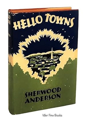
Published by Horace Liveright, New York, 1929
- Hardcover
- First Edition
Seller: Idler Fine Books, Sacramento, CA, U.S.A.Idler Fine Books
Contact seller4-star sellerCondition: Used - Fine
US$ 60.00
US$ 6.98 shippingShips within U.S.A.Quantity: 1 available
Hardcover. Condition: Fine. Dust Jacket Condition: Very Good. 1st Edition. First printing of the first edition, first issue with text error, also includes the publisher's Mid-Winter 1929, 8 page book-order form, loosely laid-in. Tiny bump to bottom front corner and small rubbed area to edge of upper back cover, else book in fine… condition; dust jacket with a closed tear from bottom to mid-front cover, closed tear from top front cover to letter O of title, tiny closed tear to upper back cover, mild chipping/wear to extremities, faint toning to spine and folds, else fine. Tom Ewald (Frontis map and illustrations); Sherwood Anderson (Black-and-white Ppotos); Jácks (illustrator).
Published by Department Of Education
- Hardcover
Seller: Terrace Horticultural Books, St. Paul, MN, U.S.A.Terrace Horticultural Books
Contact seller4-star sellerCondition: Used - Very good
US$ 40.00
US$ 6.99 shippingShips within U.S.A.Quantity: 1 available
Hardcover. Condition: Very Good. Copyright Date: 1937 Sm Quarto, PP.165. B & W Photos, Text Figures, Map (illustrator).
 More images
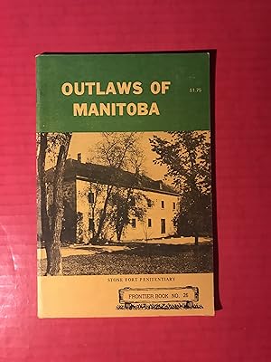
Published by Frontier Publishing Ltd., Aldergrove B. C., 1971
- Softcover
- First Edition
Seller: COVENANT HERITAGE LIBRIS, Saint John, NB, CanadaCOVENANT HERITAGE LIBRIS
Contact seller5-star sellerCondition: Used - Good
US$ 7.00
US$ 41.00 shippingShips from Canada to U.S.A.Quantity: 1 available
Soft cover. Condition: Good. First Edition. binding tight, no markings, W1 2. Map & Photo Reproductions (illustrator).
 More images
Published by Frontier Publishing Ltd., Aldergrove B. C., 1977
- Softcover
Seller: COVENANT HERITAGE LIBRIS, Saint John, NB, CanadaCOVENANT HERITAGE LIBRIS
Contact seller5-star sellerCondition: Used - Good
US$ 7.00
US$ 41.00 shippingShips from Canada to U.S.A.Quantity: 1 available
Soft cover. Condition: Good. second edition. soiling staining, binding tight, owners name. W1 2. Map & Photo Reproductions (illustrator).
 More images
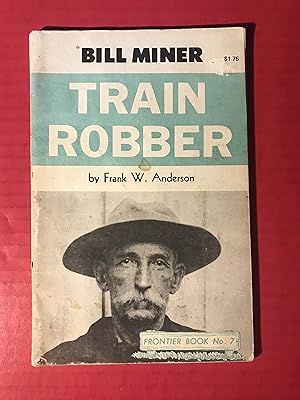
Published by Frontier Publishing Ltd., Aldergrove B. C., 1969
- Softcover
- First Edition
Seller: COVENANT HERITAGE LIBRIS, Saint John, NB, CanadaCOVENANT HERITAGE LIBRIS
Contact seller5-star sellerCondition: Used - Good
US$ 7.00
US$ 41.00 shippingShips from Canada to U.S.A.Quantity: 1 available
Soft cover. Condition: Good. First Edition. binding tight, no markings. W1 2. Map & Photo Reproductions (illustrator).
 More images
Language: English
Published by Shearer Publishing, Fredericksburg, Texas, 2002
- Hardcover
- First Edition
- Signed
Seller: Vero Beach Books, Vero Beach, FL, U.S.A.Vero Beach Books
Contact seller5-star sellerCondition: Used - As new
US$ 95.00
Free ShippingShips within U.S.A.Quantity: 1 available
Hardcover. Condition: As New. Dust Jacket Condition: Fine. 1st Edition. As new condition maroon cloth boards with gold spine lettering contained in a fine condition non price-clipped color photographic dust jacket. Includes Acknowledgments and Index. Profusely illustrated with color photographs and full color front and rear endp…aper maps. Signed and inscribed by the author, Terry Thompson-Anderson, with thin black ink at the upper left corner of the half title page. "Terry Thompson-Anderson's recipes are vibrant and full of flavors from "Deep in the Heart of Texas." They shine as brightly as the "Stars at Night" in the Texas sky. It's a book you will cherish, use often, and enjoy." - Paula Lambert, cheesemaker and founder of the Mozzarella Company, Dallas. ".Terry Anderson has brought together the myriad culinary threads that have woven together to define Texas cuisine today. Indigenous dishes are overlaid with ethnic ingredients that reflect the state's varied population as well as Terry's creative palate. She delights the reader with bits of Texas history and folklore that are amusing as well as pertinent to her food concepts. The book is sheer delight!" - Virginia Elverson, culinary consultant and author of Gulf Coast Cooking. "Terry Thompson-Anderson is back with a mouthwatering collection of recipes so full of flavor that they practically jump right off the page!" - Sharon Tyler Herbst, author of The New Food Lover's Companion. "In Texas on the Plate, executive chef and cookbook author Terry Thompson-Anderson demonstrates her flair for combining unusual flavors and diverse ethnic cooking styles to create exciting examples of the new Texas Cuisine. Among the more than 150 recipes are upscale interpretations of traditonal favorites like chili and barbecued brisket as well as adventurous dishes such as Grilled Portabello Pizzas, Shark Steaks Grilled in Hoja Santa with Sun-Dried Tomato and Walnut Pesto, Texas Chicken-Fried Rib-Eye with Tabasco Cream Gravy, Quinoa with Lentils and Curry, and Texas Trifle with Rasberries and Custard Cream. In addition to professional cooking tips, the book includes wine lists, and tasting notes that highlight many of the state's award-winning wines. The lavish color photographs of scenic photographer Bob Parvin and food photographer Ralph Smith capture the glory of the Lone Star landscapes and foods." - from the inner front jacket flap. Smith, Ralph (food photography); Parvin, Bob (location photography); Jezek, Barbara (book design); Wilson, John A. (map illustration) (illustrator). Signed by Author(s).

- Hardcover
Seller: BOP Books, Tauranga, New ZealandBOP Books
Contact seller1-star sellerCondition: Used - Fine
US$ 72.27
US$ 29.00 shippingShips from New Zealand to U.S.A.Quantity: 1 available
Hardcover. Condition: NF. Dust Jacket Condition: VG+. 1st. When Napoleon invaded Egypt in 1798 his army was not entirely military. The expedition included a 165 strong Commission of Arts and Science, which was to examine all aspects of Egypt, contemporary and ancient. The results of the findings, observations, collections and ar…tistic impression were published in the "Description de l'Egypte", but this task took many years, employed 400 engravers and up to 2000 others each year. The outcome was described as "without parallel in the annals of historical research." However, the first edition was circulated in only small numbers, particularly in France itself. In 1820 the decision was made to produce a second revised edition, by which time 900 engraved plates had been completed. It is in these that the real fruits of Napoleon's expedition to Egypt are found today. A selection of 174 of these plates appears in "Egypt in 1800" and they cover three aspects of the country; ancient, medieval and modern and modern Egyptians. .A breathtaking publication, with an amazing history of its own. 196 pages including list of plates and concordance, also one map. Cream hard covers with gilt spine titles NF, ditto text block, no inscriptions. Colour art DJ is VG+ with a few chips. A large/heavy book, 1.6kgs unpacked --- would require additional postage for overseas delivery. Art, Map (illustrator).

Published by The Ryerson Press, Toronto, 1961
- Hardcover
- First Edition
Seller: Dave Shoots, Bookseller, Saint John, NB, CanadaDave Shoots, Bookseller
Contact seller5-star sellerCondition: Used - Very good
US$ 50.00
US$ 20.00 shippingShips from Canada to U.S.A.Quantity: 1 available
Hardcover. Condition: Very Good. Dust Jacket Condition: Good. 1st Edition. Original navy cloth over boards with gilt lettering. Dark brown pictorial dustjacket features black and white photo of the author on cover, with white lettering. Dustjacket has edge and corner wear, and is missing several small pieces along the edge. Rema…ins of adhesive on half-title where previous owner's bookplate was probably attached. Lord Tweedsmuir (John Buchan) wrote the Foreword for this autobiography of a fur trader who worked for the Hudson's Bay Company in the Canadian North from 1910 to 1958. 245 pp. Size: 8vo - over 7¾ - 9¾" tall. B & W Photos, Map Endpapers (illustrator). Book.
 More images
Published by Chapman & Hall 1888 (1887cp), London, 1888
- Hardcover
Seller: Quiet Friends IOBA, Lyndonville, NY, U.S.A.Quiet Friends IOBA
Contact seller4-star sellerAssociation member: IOBA
Condition: Used - Good
US$ 117.00
US$ 3.00 shippingShips within U.S.A.Quantity: 1 available
Hardcover. Condition: Good. 2nd edition. GOOD book. Tight. Clean in & out. FINE inside. f/o map w two 1" tears & one shorter, all w old tape repairs. Worn, spine ends torn. Gilt on spine letters totally faded. 1st publ, also by C&H, in 1887 in two vols. Title was "25 years in a Waggon in Gold Regions of Africa". This 1888 editio…n contains about 20% new material. Author travelled thru Natal, Griqualand, Namaqualand, Damaraland & Ovampoland; commenting on hunting, the animal population & the various Africans encountered. Seems to be an unbiased (for the time) observer. He frequently sees the members of many tribes to be better off than their European counterparts. He almost died of thirst crossing the Kalahari. GOOD book. Czech p 4. Orig green boards, gilt spine lettering. 14 full p illus & f/o map. (illustrator).

Published by University Press of Florida (1999), Gainesville, 1999
- Hardcover
Seller: Expatriate Bookshop of Denmark, Svendborg, DenmarkExpatriate Bookshop of Denmark
Contact seller5-star sellerCondition: Used
US$ 59.00
US$ 67.67 shippingShips from Denmark to U.S.A.Quantity: 1 available
orig. cloth. Condition: Minor wear. VG. 23x16cm, x,197 pp. Contents: The Context & Structure of the Directorate; The Economic Basis of Settlement in the 18th Century; The Elites & their Role in Colonization;Basic Decisions in Colonization; Policy & Living Conditions; Migration & Demographic Change. Textual map. (illustrator).
 More images
Published by Anderson Map Co., 1910
- Hardcover
Seller: Barry Lawrence Ruderman, La Jolla, CA, U.S.A.Barry Lawrence Ruderman
Contact seller5-star sellerCondition: Used - Very good
US$ 1,600.00
US$ 14.50 shippingShips within U.S.A.Quantity: 1 available
Hardcover. Condition: vg. Large-format Atlas of Whitman County, Washington The detailed color plats show townships, towns, railroads, roads, and individual landholdings throughout Whitman County at the height of its early twentieth-century a. Folio. Original half red leather over pebbled cloth, stamped in blind and gilt. Sp…ine ends chipped. Corners worn. 80, [24] pages. Comprising 80 pages of color plat maps (plus unnumbered key map at front), [16] pages "supplement" which includes 2-sheet Cram map of the U.S. and 2-sheet Map of the World, and four pages of black and white portraits of landowners. Housed in a custom blue & yellow cloth clamshell box. Large-format Atlas of Whitman County, Washington The detailed color plats show townships, towns, railroads, roads, and individual landholdings throughout Whitman County at the height of its early twentieth-century agricultural development, and the work appears to be one of the earliest comprehensive, locally produced land-ownership atlases of the county, rarely encountered in commerce.The atlas was issued by the Anderson Map Company of Seattle, the successor to O. P. Anderson & Co. and the O. P. Anderson Map & Blue Print Company, one of Seattle s first home-grown map-publishing firms, which produced important guide and county maps for King, Chehalis, Cowlitz and other Washington counties, as well as a celebrated 1909 Official Map of Greater Seattle. The founder, Oliver Phelps Anderson (1859 1941), was a Seattle-based draughtsman, civil engineer, cartographer and photographer who built a thriving map and photographic-supply business from the late 1880s onward, making this Whitman County plat book a representative but now quite scarce product of his influential regional mapping enterprise.Whitman CountyWhitman County, in southeastern Washington s Palouse region, was formed on November 29, 1871; and was named for Marcus Whitman, the missionary associated with the Whitman Mission who was killed in 1847 during the conflict often called the Whitman Massacre. Long before Euro American settlement and wheat farming reshaped the rolling loess hills, the area formed part of the seasonal homelands and travel corridors of Palouse and Nez Perce peoples, among other Plateau communities, who hunted, gathered, traded, and moved along the Snake River system. In the late nineteenth century the county s development accelerated with agricultural settlement and rail-linked market towns, a pattern still visible in its principal communities today, led by Pullman and Colfax, and including Palouse, Tekoa, Rosalia, Uniontown, Albion, and Malden.RarityQuite rare in the market. Only a single example noted in RBH. Book.
 More images
Published by Anderson Map Co., 1910
- Hardcover
Seller: Barry Lawrence Ruderman, La Jolla, CA, U.S.A.Barry Lawrence Ruderman
Contact seller5-star sellerCondition: Used - Very good
US$ 1,600.00
US$ 14.50 shippingShips within U.S.A.Quantity: 1 available
Hardcover. Condition: vg. First Atlas of Snohomish CountyThis rare 1910 cadastral atlas provides a comprehensive record of early 20th-century land ownership, settlement, and development across Snohomish County, Washington, showing areas which now. Front cover detached but retained. First Atlas of Snohomish CountyThis rare 1910 c…adastral atlas provides a comprehensive record of early 20th-century land ownership, settlement, and development across Snohomish County, Washington, showing areas which now include parts of suburban Seattle.Compiled by the Anderson Map Company under the direction of James W. Myers, the atlas presents a complete township-by-township and town-by-town survey of the county based on official records, private plat filings, and on-site measurements. The large-scale colored maps identify land parcels, individual property owners, homesteads, schools, mills, roads, ferry routes, and railways as they existed during the height of early settlement and commercial expansion.Among the most striking elements are the detailed plats of urban areas such as Everett, Snohomish, Marysville, Monroe, and Arlington, each shown with block and lot subdivisions, named additions, and outlines of individual buildings. Smaller towns and farming communities are likewise carefully recorded. The inclusion of a Patrons Directory provides a rare genealogical and local history resource, listing landholders and their locations within each township.This is a fine example of Western cartographic publishing in the early 20th century, and a vital visual document for the study of local history, land use, genealogy, and development patterns in the Pacific Northwest. Snohomish CountySnohomish County, established in 1861 and named after the Indigenous Coast Salish Snohomish people, developed rapidly in the late 19th century with the rise of logging, milling, and rail transportation. The county was originally carved from Island County and quickly became a key node in the Puget Sound lumber trade.By the 1910s, cities like Everett had grown into major industrial centers with shipbuilding, sawmills, and paper manufacturing, while smaller communities flourished with agricultural and timber resources. The plat book documents this pivotal moment of regional transformation and civic organization just before the Pacific Northwest's broader wave of urbanization.RarityThe atlas is very rare on the market.We note no prior auction or dealer catalog records on RBH. Book.

- Map
Seller: Geographicus Rare Antique Maps, Brooklyn, NY, U.S.A.Geographicus Rare Antique Maps
Contact seller4-star sellerVery good. Light wear along original fold lines. Verso repairs to fold separations. Size 23.25 x 18.75 Inches. This is a 1956 Margaret Anderson and R. Bruce Moulder road map of Barbados. Red lines highlight major highways, while red and black dashed lines follow secondary highways. Distances along the major highways are marked b…y small numbers near the route. Roads marked by two thin black parallel lines are 'other roads' per the key situated in the lower right corner. Symbols mark churches, lighthouses, police stations, and gas stations around the island. Cities, towns, and other settlements are identified, along with coastal locations and various other inland locations. An inset of Bridgetown and its environs is situated in the upper right. Here, Anderson and Moulder identify parks, a playing field, cemeteries, schools, and churches. Publication History and Census This map was compiled by Margaret Swainson Anderson in 1952 and revised by Richard Bruce Moulder in 1956. We have located cataloged examples of earlier and later editions in institutional collections, but the present example of the 1956 edition is the only cataloged example of this edition.
 More images
Morro Bay to San Diego California Generalized Areal Geology / Physical and Legal Limitations to Operations Morro Bay to San Diego California.
1973 Nisbet / Anderson Manuscript Geological, Oil and Gas Map of Southern California
- Map
Seller: Geographicus Rare Antique Maps, Brooklyn, NY, U.S.A.Geographicus Rare Antique Maps
Contact seller4-star sellerGood. Wear along original fold lines. Several tears along border and at fold junctions professionally repaired. Some surface scuffing. Size 48.5 x 35 Inches. An unusual large-format composite manuscript and diazotype geological map of Southern California, produced in 1973 by G. J. Anderson of the Challenger Oil and Gas Co., base…d on an earlier 1966 map by J. M. Nisbet. In addition to geological information, the map also indicates coastal reserves open for development and traces the outlines of the region's historic Spanish and Mexican ranchos. A Closer Look The map covers a large portion of Southern California from Morro Bay in the Central Coast region to the Mexican border, including Santa Barbara, the Los Angeles metropolitan area, and San Diego, with a focus on the coastal waters of the Pacific Ocean. Hachure lines mark submarine elevation, particularly along the closely packed ridges and basins of the Southern California Borderland, also known as the California Continental Borderland. A system of color shading explained at left differentiates geologic eras, volcanic, and intrusive rock. Areas shaded light red on land might indicate oil reserves, as in northern Santa Barbara County at top and at various points around Los Angeles County. In addition to the long eras of geologic time indicated, more recent features are illustrated on land, including county boundaries, highways, and railways. These include highly detailed documentation of the historic Spanish and Mexican ranchos of Southern California, which presumably have no geological significance. The verso presents the same diazotype base map as on the recto but instead highlights coastal areas suitable for oil and gas exploitation in light of legal considerations. It mentions the 1955 Shell-Cunningham Tidelands Act, a law passed by California's state legislature that amended an earlier 1938 law restricting offshore oil and gas development. The 1955 law provided for coastal 'sanctuaries,' especially near heavily populated areas, but otherwise opened up considerably more coastal waters to oil and gas development, as indicated here, with the State Lands Commission authorized to negotiate leases. Afterward, from the late 1950s to the late 1960s, many new leases were granted along the Southern California coast, allowing for increased offshore oil and gas field exploitation until environmental concerns in the 1970s saw a turn towards greater restrictions. Diazo Print or Whiteprint The diazo print (whiteprint or diazo for short) is a photo reproductive technique best understood as a reverse cyanotype or blueprint. The process yields distinctive blue lines on white paper. Like cyanotypes, the diazo process gained popularity in architecture circles, where it was a simple and effective way to duplicate documents in the field. The earliest diazotypes appeared around 1880 and were adopted for military and field cartographic use from about 1895. The diazo process was commercialized in 1923 when the German firm Kalle and Company developed Ozalid, a patented diazo paper that made diazotyping even easier. By the 1950s, it supplemented cyanotypes as the reprographic technique of choice for technical drawings. Publication History and Census The recto map was originally prepared by J. M. Nisbet, seemingly of the Standard Oil Company of Southern California (later Chevron) in 1966, and the verso map was prepared by the same in 1965 (itself seemingly an update of an earlier 1963 map). The recto map was updated in 1973 by G. J. Anderson for the Challenger Oil and Gas Co. (a subsidiary of Global Marine Inc., different from today's company of the same name that operates in Northern Africa, which was founded in 1991). Though based on an earlier map, the annotations here are in manuscript, making it a unique production. Being diazotypes, these maps were meant for administrative use and were ephemeral in nature.


