Andriveau Goujon Eugene (93 results)
Language: German
Published by Paris 1860
- Map
Seller: Antiquariat Steffen Völkel GmbH, Seubersdorf, GermanyAntiquariat Steffen Völkel GmbH
Contact seller5-star sellerCondition: Used
US$ 11.81
US$ 34.43 shippingShips from Germany to U.S.A.Quantity: 1 available
original handkolorierte alte Stahlstich-Landkarte von ca. 1860 von Eugene Andriveau-Goujon (1832-1897) - Blatmasse: ca. 68 x 53 cm - im Mittelfalz mit Randeinriss außerhalb der Karte, sonst gut erhalten. | original hand colored old steel engraving from circa 1860 by Eugene Andriveau-Goujon - size of sheet: circa 26.7 x 20.8 inch…es - with marginal tear in middle fold outside the map, otherwise in good condition. | Dies ist ein Original! - Kein Nachdruck! - Keine Kopie! -- This is an original! - No copy! - No reprint! // Wir, das Antiquariat Steffen Völkel, kaufen und verkaufen alte Bücher, Handschriften, Zeichnungen, Autographen, Grafiken und Fotografien. Wir sind stets am Ankauf von kompletten Bibliotheken, Sammlungen und Nachlässen interessiert. Sprache: Deutsch Gewicht in Gramm: 1500.
Language: German
Published by Paris 1862
- Map
Seller: Antiquariat Steffen Völkel GmbH, Seubersdorf, GermanyAntiquariat Steffen Völkel GmbH
Contact seller5-star sellerCondition: Used
US$ 11.81
US$ 34.43 shippingShips from Germany to U.S.A.Quantity: 1 available
original handkolorierte alte Stahlstich-Landkarte von 1862 von Eugene Andriveau-Goujon (1832-1897) - Blatmasse: ca. 68 x 53 cm - gut erhalten. | original hand colored old steel engraving from 1862 by Eugene Andriveau-Goujon - size of sheet: circa 26.7 x 20.8 inches - good condition. | Dies ist ein Original! - Kein Nachdruck! - K…eine Kopie! -- This is an original! - No copy! - No reprint! // Wir, das Antiquariat Steffen Völkel, kaufen und verkaufen alte Bücher, Handschriften, Zeichnungen, Autographen, Grafiken und Fotografien. Wir sind stets am Ankauf von kompletten Bibliotheken, Sammlungen und Nachlässen interessiert. Sprache: Deutsch Gewicht in Gramm: 1500.

Language: German
Published by Paris 1850
- Map
Seller: Antiquariat Steffen Völkel GmbH, Seubersdorf, GermanyAntiquariat Steffen Völkel GmbH
Contact seller5-star sellerCondition: Used
US$ 23.63
US$ 34.43 shippingShips from Germany to U.S.A.Quantity: 1 available
original handkolorierte alte Stahlstich-Landkarte von ca. 1850 von Eugene Andriveau-Goujon (1832-1897) - Blatmasse: ca. 68 x 53 cm - gut erhalten. | original hand colored old steel engraving from circa 1850 by Eugene Andriveau-Goujon - size of sheet: circa 26.7 x 20.8 inches - good condition. | Dies ist ein Original! - Kein Nach…druck! - Keine Kopie! -- This is an original! - No copy! - No reprint! // Wir, das Antiquariat Steffen Völkel, kaufen und verkaufen alte Bücher, Handschriften, Zeichnungen, Autographen, Grafiken und Fotografien. Wir sind stets am Ankauf von kompletten Bibliotheken, Sammlungen und Nachlässen interessiert. Sprache: Deutsch Gewicht in Gramm: 1500.
Language: German
Published by Paris 1862
- Map
Seller: Antiquariat Steffen Völkel GmbH, Seubersdorf, GermanyAntiquariat Steffen Völkel GmbH
Contact seller5-star sellerCondition: Used
US$ 23.63
US$ 34.43 shippingShips from Germany to U.S.A.Quantity: 1 available
original handkolorierte alte Stahlstich-Landkarte von 1862 von Eugene Andriveau-Goujon (1832-1897) - Blatmasse: ca. 68 x 53 cm - gut erhalten. | original hand colored old steel engraving from 1862 by Eugene Andriveau-Goujon - size of sheet: circa 26.7 x 20.8 inches - good condition. | Dies ist ein Original! - Kein Nachdruck! - K…eine Kopie! -- This is an original! - No copy! - No reprint! // Wir, das Antiquariat Steffen Völkel, kaufen und verkaufen alte Bücher, Handschriften, Zeichnungen, Autographen, Grafiken und Fotografien. Wir sind stets am Ankauf von kompletten Bibliotheken, Sammlungen und Nachlässen interessiert. Sprache: Deutsch Gewicht in Gramm: 1500.

Language: German
Published by Paris 1862
- Map
Seller: Antiquariat Steffen Völkel GmbH, Seubersdorf, GermanyAntiquariat Steffen Völkel GmbH
Contact seller5-star sellerCondition: Used
US$ 23.63
US$ 34.43 shippingShips from Germany to U.S.A.Quantity: 1 available
original handkolorierte alte Stahlstich-Landkarte von 1862 von Eugene Andriveau-Goujon (1832-1897) - Blatmasse: je ca. 68 x 53 cm - im Falz mit Randeinriss, sonst gut erhalten. | original hand colored old steel engraving from 1862 by Eugene Andriveau-Goujon - size of sheet: each circa 26.7 x 20.8 inches - with marginal tear in m…iddle fold, otherwise in good condition. | Dies ist ein Original! - Kein Nachdruck! - Keine Kopie! -- This is an original! - No copy! - No reprint! // Wir, das Antiquariat Steffen Völkel, kaufen und verkaufen alte Bücher, Handschriften, Zeichnungen, Autographen, Grafiken und Fotografien. Wir sind stets am Ankauf von kompletten Bibliotheken, Sammlungen und Nachlässen interessiert. Sprache: Deutsch Gewicht in Gramm: 1500.
 More images
Language: French
Published by ANDRIVEAU-GOUJON, Paris 1881
- Hardcover
Seller: Argosy Book Store, ABAA, ILAB, New York, NY, U.S.A.Argosy Book Store, ABAA, ILAB
Contact seller5-star sellerhardcover. Case Map. Lithograph with original hand coloring. Map measures 41 1/2" x 32 1/8" . 8 1/4" x 4 5/8" brown case with title embossed in gold. Gorgeous, highly detailed pocket map of Paris and its environs. Includes inset maps of plans for Bois de Boulogne and Bois de Vicennes which bookend the city on it's western and ea…stern perimeters respectively. Backed on canvas, in very good condition, some wear along folds of original linen. Eugene Andriveau-Goujon (1832 - 1897) was a French cartographer and and map publisher. He was a descendant of mapmaker Jean Goujon, who established the Andriveau-Goujon firm in Paris in 1825.

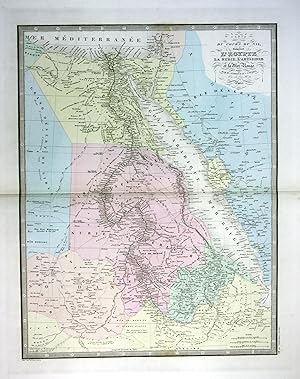
Language: French
Published by Paris, E. Andriveau-Goujon, Éditeur 1870
- Map
Seller: Antiquariat Braun, Gengenbach, , GermanyAntiquariat Braun
Contact seller5-star sellerCondition: Used - Very good
US$ 53.19
US$ 45.90 shippingShips from Germany to U.S.A.Quantity: 1 available
Condition: Gut. Format: 50,8 x 66,7 cm. Blatt: 51 x 68 cm. *Als Kupferstecherin bzw. Kupferstecher werden angegeben "Gravée par Mlle. Flahaut et Smith". Weitere Angaben: "Les Ecritures par P. Rousset, les Eaux par Mme. Fontaine"; "Imp.ie de Louis Antoine". - Die Karte untergliedert die Region noch nicht in die klassischen vier S…ubregionen Australasien, Melanesien, Mikronesien, and Polynesien, sondern nur Melanesien, das Mailaiische Archipel und die Inseln des Pazifiks. Sprache: Französisch Gewicht in Gramm: 1001.

Published by Paris, Imp. de Louis Antoine, 1859. 1859
- Hardcover
Seller: Antiquariat MEINDL & SULZMANN OG, Wien - Vienna, , AustriaAntiquariat MEINDL & SULZMANN OG
Contact seller5-star sellerCondition: Used
US$ 212.75
US$ 40.16 shippingShips from Austria to U.S.A.Quantity: 1 available
8°. In 32 Segmenten auf Leinen aufgezogen und faltbar eingerichtet (ca. 72,5 x 104 cm). Mit der nordafrikanischen Küstenlinie (Marokko, Algerien, Tunis, Libyen, Ägypten) und den Anlegestellen der Dampfschiffe.- Die Leinenrückseite gebräunt, stellenweise braunfleckig und mit Verlagsschildchen von Artaria in Wien. Das Kartenbild i…n nahezu fleckenfreiem Erhaltungszustand.
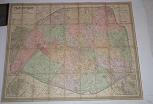
Published by Paris : Maison Andriveau-Goujon- H.Barrère. 1900
- Hardcover
Seller: Wittenborn Art Books, San Francisco, CA, U.S.A.Wittenborn Art Books
Contact seller4-star sellerCondition: Used - Good
US$ 350.00
US$ 10.00 shippingShips within U.S.A.Quantity: 1 available
Condition: Good. Original gilt stamped lcoth with map mouend on linen 85 x 110 cm. folding to 13 x 21cm.OCLC Number: 27861884 for the 1870 edition.PLAN DE PARIS 1/12.500Maison Andriveau Goujon. 190085 x110 cm, colorié, entoilé.

Language: French
Published by Paris, 1856. 1856
- Signed
Seller: Versandantiquariat Wolfgang Friebes, Graz, , AustriaVersandantiquariat Wolfgang Friebes
Contact seller5-star sellerCondition: Used
US$ 177.29
US$ 83.20 shippingShips from Austria to U.S.A.Quantity: 1 available
2 S. auf Doppelblatt, 8°. Andriveau-Goujon war Herausgeber zahlreicher Atlanten und geographischer Werke. - Der Empfänger des auf Französisch abgefassten Briefes ist Jacques (Jacob) Mislin (1807-1878). Der aus ärmlichen Verhältnissen stammende Mislin konnte dank seines Onkels an der berühmten Lehranstalt von Porrentruy im Schwei…zer Kanton Bern studieren, wo er nicht viel später auch selbst unterrichten sollte. Der 1830 zum Priester geweihte kath. Theologe wurde 1836 auf Vermittlung des Grafen von Bombelle an den Wiener Hof berufen, wo er einer der Lehrer der Söhne von Erzherzog Franz Karl und Erzherzogin Sophie wurde und damit sowohl den zukünftigen Kaiser Franz Joseph wie auch Erzherzog Ferdinand Maximilian (später Kaiser Max von Mexiko) unterrichtete (u.a. auch in Erdkunde). Vor der Revolution von 1848 unternahm Mislin eine Pilgerreise von Wien über Budapest und Konstantinopel nach Jersusalem. Der danach erschienene Reisebericht wurde in mehrere Sprachen übersetzt und mehrfach nachgedruckt. In den folgenden Jahren leitete er die Bibliothek am Hof der Herzogin von Parma, Erzherzogin Marie Louise, wurde zum Abt von St. Maria von Deg (Ungarn), geheimer Kämmerer u. Hausprälat Papst Pius' XI., Apostolischer Pronotar, Kanoniker der Kathedrale von Großwardein, Träger zahlr. Orden (u.a. von Spanien, Parma u. des Ritterordens vom Heiligen Grab zu Jerusalem) sowie Mitglied zahlr. Akademien. Der Verfasser zahlr. Publikationen und Vertraute des belgischen Königs und des Grafen von Chambord blieb nach der Rückkehr von seiner Pilgerreise in Wien, wo er weiterhin in persönlichem Kontakt mit dem Kaiserhaus stand. - In einem numerierten, von Mislin eigenh. beschrifteten Papierumschlag. - Das erste Bl. m. Eckknick. Sprache: Französisch Gewicht in Gramm: 500.
 More images
Published by Paris, France: Andriveau-Goujon. 1881
- Manuscript
Seller: Wittenborn Art Books, San Francisco, CA, U.S.A.Wittenborn Art Books
Contact seller5-star sellerCondition: Used - Good
US$ 150.00
US$ 10.00 shippingShips within U.S.A.Quantity: 1 available
Condition: Good. Four Maps 18.75" x 13.75" (per quadrant). Good with tears, toning. Some color. Text En Francais.

Published by Paris. 1843 1843
Seller: Peter Harrington. ABA/ ILAB., London, United KingdomPeter Harrington. ABA/ ILAB.
Contact seller5-star sellerCondition: Used
US$ 163.56
US$ 29.11 shippingShips from United Kingdom to U.S.A.Quantity: 1 available
An attractive detailed map of the north of Algeria and Tunisia, including Malta, Sardinia and Corsica, with inset maps of Oran, Algiers, Bougie and Constantine. From the Atlas Universel Steel engraving. Good clean condition, good wide margins. the lower 12 cm of centrefold has split, no loss Later colouring. Size: 51 x 39 cm. (2…0 x 15½ inches).

Condition: Used - Good
US$ 283.67
US$ 57.38 shippingShips from Spain to U.S.A.Quantity: 1 available
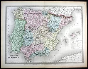
Condition: ACEPTABLE. [Un] Mapa de España tal y como se encontraban los reinos de España y Portugal a principios del siglo XIX. Publicada en París en 1837 por el cartógrafo J. Andriveau-Goujon. El mapa, que destaca por su exquisito detalle grabado y un elegante marco ornamental con caligrafía artística, ofrece una representación… exhaustiva de la Península Ibérica, mostrando la compleja orografía montañosa, las cuencas hidrográficas y una densa red de poblaciones y divisiones territoriales de la época. Título completo: "Carte des Royaumes d'Espagne et de Portugal Publiée par J. Andriveau-Goujon. Rue du Bac, n.6. Paris, 1837.". Formato (cm): 51x66.

Published by Parigi 1870
- Art Print
Seller: libreria antiquaria perini Sas di Perini, Verona, VR, Italylibreria antiquaria perini Sas di Perini
Contact seller5-star sellerCondition: Used
US$ 413.69
US$ 45.90 shippingShips from Italy to U.S.A.Quantity: 1 available
Litografia a colori, mm 1050x610. Stato di conservazione perfetto. Piega editoriale centrale. Color litograph, mm 1050x610, very good condition. The map shows the United States during an interesting time in history. While much of the eastern half of the country is well developed, the western portion still shows unmapped regions…and incomplete state boundaries. The most interesting feature in the map is the odd configuration of California and Nevada, which resulted from a misunderstanding of the boundary changes that occurred when Arizona ceded land west of the Colorado and Virgin rivers to Nevada in 1866. This map shows the Nevada/Utah border too far west and the ceded region belonging to California instead of Nevada. Dakota has yet to be divided into North and South, and the borders between Idaho, Wyoming, and Montana still have yet to come to their present.Inserts show various shipping routes between Africa, Europe and the Americas as well as the newly laid Trans-Atlantic Cables. Another insert shows the region around New York City, which had by then become one of the most active and influential cities in the World. At the bottom of the map, a reference key differentiates various European possessions within the Caribbean. Nr.cat: cod 1181.

Condition: Used - Good
US$ 419.60
US$ 57.38 shippingShips from Spain to U.S.A.Quantity: 1 available
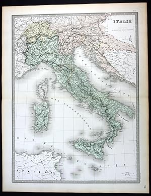
Condition: ACEPTABLE. Italie / Italia perteneciente al Atlas Classique et Universel de Géographie Ancienne et Moderne / Atlas Clásico y Universal de Geografía Antigua y Moderna de Eúgéne Andriveau-Goujon publicado en París en el año 1877. Formato (cm): 65x59.

Condition: Used - Good
US$ 419.60
US$ 57.38 shippingShips from Spain to U.S.A.Quantity: 1 available
Condition: ACEPTABLE. Pérou, Bolivie / Perú, Bolivia perteneciente al Atlas Classique et Universel de Géographie Ancienne et Moderne / Atlas Clásico y Universal de Geografía Antigua y Moderna de Eúgéne Andriveau-Goujon publicado en París en el año 1877. Formato (cm): 48x64.

Condition: Used - Good
US$ 419.60
US$ 57.38 shippingShips from Spain to U.S.A.Quantity: 1 available
Condition: ACEPTABLE. Brésil / Brasil perteneciente al Atlas Classique et Universel de Géographie Ancienne et Moderne / Atlas Clásico y Universal de Geografía Antigua y Moderna de Eúgéne Andriveau-Goujon publicado en París en el año 1877. Formato (cm): 64x49.

Condition: Used - Good
US$ 419.60
US$ 57.38 shippingShips from Spain to U.S.A.Quantity: 1 available
Condition: ACEPTABLE. Palestine, Ancienne & Moderne / Palestica, Antigua y Moderna perteneciente al Atlas Classique et Universel de Géographie Ancienne et Moderne / Atlas Clásico y Universal de Geografía Antigua y Moderna de Eúgéne Andriveau-Goujon publicado en París en el año 1877. Formato (cm): 65x49.

Condition: Used - Good
US$ 419.60
US$ 57.38 shippingShips from Spain to U.S.A.Quantity: 1 available
Condition: ACEPTABLE. États-Unis (Etats de lOuest) / Estados Unidos (Estados del Oeste) perteneciente al Atlas Classique et Universel de Géographie Ancienne et Moderne / Atlas Clásico y Universal de Geografía Antigua y Moderna de Eúgéne Andriveau-Goujon publicado en París en el año 1877. Formato (cm): 64x48.

Condition: Used - Good
US$ 419.60
US$ 57.38 shippingShips from Spain to U.S.A.Quantity: 1 available
Condition: ACEPTABLE. Carte Générale du Monde Ancien représentant lesemble des Connaissances Géographiques des Grecs et des Romains / Mapa General del Mundo Antiguo en representación de todos los Conocimientos Geográficos de los Griegos y los Romanos. Perteneciente al Atlas Classique et Universel de Géographie Ancienne et Modern…e / Atlas Clásico y Universal de Geografía Antigua y Modernade Eugéne Andriveau-Goujon publicado en París en el año 1877. Formato (cm): 39x52.

Condition: Used - Good
US$ 419.60
US$ 57.38 shippingShips from Spain to U.S.A.Quantity: 1 available
Condition: ACEPTABLE. États Scandinaves / Estados Escandinavos perteneciente al Atlas Classique et Universel de Géographie Ancienne et Moderne / Atlas Clásico y Universal de Geografía Antigua y Moderna de Eúgéne Andriveau-Goujon publicado en París en el año 1877. Noruega - Suecia - Dinamarca Formato (cm): 66x48.

Condition: Used - Good
US$ 419.60
US$ 57.38 shippingShips from Spain to U.S.A.Quantity: 1 available
Condition: ACEPTABLE. Espagne et Portugal / España y Portugal perteneciente al Atlas Classique et Universel de Géographie Ancienne et Moderne / Atlas Clásico y Universal de Geografía Antigua y Moderna de Eúgéne Andriveau-Goujon publicado en París en el año 1877. Formato (cm): 49x65.

Condition: Used - Good
US$ 419.60
US$ 57.38 shippingShips from Spain to U.S.A.Quantity: 1 available
Condition: ACEPTABLE. Perteneciente al Atlas Universel, numerado 12, 15 y 24. Ejemplar en especiales buenas condiciones y de iluminación bien definida y preservada. Incluye breve Explicatión y leyenda de símbolos, ambos en el lado derecho. [Les Chemins de Fer par Alfred Potiquet] ; [Paris_Imprimerie de Louis Antoine, Rue de Clun…y, 1] ; [Gravé : le Trait par Smith; les Montagnes par Gérin ; les Ecritures par P. Rousset; les Eaux par Mme. Fontaine.] . Formato (cm): 53x70.

Condition: Used - Good
US$ 419.60
US$ 57.38 shippingShips from Spain to U.S.A.Quantity: 1 available
Condition: ACEPTABLE. Iles Britanniques / Islas Británicas perteneciente al Atlas Classique et Universel de Géographie Ancienne et Moderne / Atlas Clásico y Universal de Geografía Antigua y Moderna de Eúgéne Andriveau-Goujon publicado en París en el año 1877. Formato (cm): 64x48.

Condition: Used - Good
US$ 419.60
US$ 57.38 shippingShips from Spain to U.S.A.Quantity: 1 available
Condition: ACEPTABLE. Confédération Argentine et Chili / Confederación de Argentinay Chile perteneciente al Atlas Classique et Universel de Géographie Ancienne et Moderne / Atlas Clásico y Universal de Geografía Antigua y Moderna de Eúgéne Andriveau-Goujon publicado en París en el año 1877. Formato (cm): 63x48.

Condition: Used - Good
US$ 466.88
US$ 57.38 shippingShips from Spain to U.S.A.Quantity: 1 available
Condition: ACEPTABLE. [Un] Mapa celeste representando los movimientos de la Tierra con respecto al sol durante las cuatro estaciones. Perteneciente a la obra titulada"Atlas Universel", núm. 5. ["Publié par E. Andriveau-Gouyon"] ; ["Composé et Dessiné par H. Nicollet"] ; ["Le Texte et les Fig. Suppl. par E. Soulier"]. (2) Formato… (cm): 48x60.
Condition: Used - Good
US$ 466.88
US$ 57.38 shippingShips from Spain to U.S.A.Quantity: 1 available
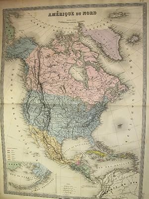
Condition: ACEPTABLE. Amérique du Nord / América del Norte perteneciente al Atlas Classique et Universel de Géographie Ancienne et Moderne / Atlas Clásico y Universal de Geografía Antigua y Moderna de Eúgéne Andriveau-Goujon publicado en París en el año 1877. Formato (cm): 65x49.

Condition: Used - Good
US$ 466.88
US$ 57.38 shippingShips from Spain to U.S.A.Quantity: 1 available
Condition: ACEPTABLE. Las Migraciones de los Pueblos. [E. Soulier del.] ; [Revu par Mr. Hase, Membre de lInstitut.] ; Perteneciente al Atlas Élémentaire Simplifié, núm. 21. Formato (cm): 43x53.

Condition: Used - Good
US$ 466.88
US$ 57.38 shippingShips from Spain to U.S.A.Quantity: 1 available
Condition: ACEPTABLE. Francia Histórica. Nueve mapas representativos de las distintas fases de Francia como país. [E. Soulier del.] ; [Revu par Mr. Hase, Membre de lInstitut.] ; Perteneciente al Atlas Élémentaire Simplifié, núm. 30. Formato (cm): 43x53.

Condition: Used - Good
US$ 466.88
US$ 57.38 shippingShips from Spain to U.S.A.Quantity: 1 available
Condition: ACEPTABLE. Carte de la Grecia Antigua, del Mar Egeo y de las Costas Occidentales de Asia Menor. [Atlas Universel, Nº 9.]. En Atlas de Choix, ou Recueil des Meilleures Cartes de Géographie Moderne, dressées par divers Auteurs. París, Chez J. Andriveau-Goujon, rue du Bac, Nº 21. Formato (cm): 42x55.


