
Order Total (1 Item Items):
Shipping Destination:

Arab Office (24 results)
Skip to main search results
Search filters
Product Type
- All Product Types
- Books (21)
- Magazines & Periodicals (No further results match this refinement)
- Comics (No further results match this refinement)
- Sheet Music (No further results match this refinement)
- Art, Prints & Posters (2)
- Photographs (No further results match this refinement)
- Maps (1)
- Manuscripts & Paper Collectibles (No further results match this refinement)
Condition Learn more
- New (9)
- As New, Fine or Near Fine (2)
- Very Good or Good (7)
- Fair or Poor (No further results match this refinement)
- As Described (6)
Binding
Collectible Attributes
- First Edition (2)
- Signed (No further results match this refinement)
- Dust Jacket (1)
- Seller-Supplied Images (15)
- Not Print on Demand (18)
Language (2)
Free Shipping
Seller Location
Seller Rating
-

Tension and Peace in the Middle East: Facts That Every American Should Know About the Tragedy of the Holy Land
Language: English
Published by Hassell Street Press, 2021
ISBN 10: 1013698274 ISBN 13: 9781013698279
Condition: New.
-

Tension and Peace in the Middle East: Facts That Every American Should Know About the Tragedy of the Holy Land (Paperback or Softback)
Language: English
Published by Hassell Street Press 9/9/2021, 2021
ISBN 10: 1013698274 ISBN 13: 9781013698279
Paperback or Softback. Condition: New. Tension and Peace in the Middle East: Facts That Every American Should Know About the Tragedy of the Holy Land. Book.
-
Tension and Peace in the Middle East: Facts That Every American Should Know About the Tragedy of the Holy Land
Language: English
Published by Hassell Street Press, 2021
ISBN 10: 1013698274 ISBN 13: 9781013698279
Condition: As New. Unread book in perfect condition.
-

Population Census in Syrian Arab Republic, 1970. Vol. 1.
Published by Syrian Arab Republic, Office of the Prime Minister, Central Bureau of Statistics, 310 Pp.
Soft Cover. Condition: Good. Softcovers; text in English and Arabic; staple-bound; with stamps "Property of Population Research Center"; spine reinforced with tape; minor shelfwear w/ light creasing of corners of wraps and leaves; o/w in good condition.
-
Tension and Peace in the Middle East: Facts That Every American Should Know About the Tragedy of the Holy Land
Language: English
Published by Hassell Street Press, 2021
ISBN 10: 1013698274 ISBN 13: 9781013698279
Seller: GreatBookPricesUK, Woodford Green, United Kingdom
Seller rating 5 out of 5 stars

US$ 22.00
US$ 20.16 shipping
Ships from United Kingdom to U.S.A.Quantity: Over 20 available
Add to basketCondition: As New. Unread book in perfect condition.
-
Tension and Peace in the Middle East: Facts That Every American Should Know About the Tragedy of the Holy Land
Language: English
Published by Hassell Street Press, 2021
ISBN 10: 1013698274 ISBN 13: 9781013698279
Seller: GreatBookPricesUK, Woodford Green, United Kingdom
Seller rating 5 out of 5 stars
US$ 30.26
US$ 20.16 shipping
Ships from United Kingdom to U.S.A.Quantity: Over 20 available
Add to basketCondition: New.
-
The Expulsion Of The Palestine Arabs Fro Their Homeland : A Dark Page In Jewish History [Propaganda, Politics, Illustrated, History, Religion, Pov 1961, Commentary, Essay]
Published by The Palestine Arab Refugee Office New York 1961/Undated Lar Reprint 0, 1961
Paperback, folded chapbook. Condition: Very Good. Dust Jacket Condition: No Dust Jacket. Modern reprint, no edition stated. 40 Pages. Chapbook, Booklet. Modern Reprint In Very Good Condition, Undated Reprint. Soft Cover, Glossy Card Covers. Paperback, With Some Slight Wear, Minimal. 40 p. Book.
-
![Seller image for The Expulsion of the Palestine Arabs fro Their Homeland : a Dark Page in Jewish History [propaganda, Politics, Illustrated, History, Religion, POV 1961] for sale by GREAT PACIFIC BOOKS](https://pictures.abebooks.com/inventory/md/md4435099449.jpg)
The Expulsion of the Palestine Arabs fro Their Homeland : a Dark Page in Jewish History [propaganda, Politics, Illustrated, History, Religion, POV 1961]
Published by the Palestine Arab Refugee Office New York 1961, Pages are Aged, Yet Clean, 1961
Condition: Good. Dust Jacket Condition: No Dust Jacket. Some b/w Illustrations (illustrator). Inside spine has prior moisture stains. Paperback : soft cover edition in good condition, a typical used book with slight wear to edges and spine. Some minor bumping or creases. Overall good / nice copy of this scarce title. Excellent reading on the subject. A good book to enjoy and keep on hand for yourself. Or would make an ideal gift for the fan / reader in your life. Reading is one of the great pleasures in life. Please send us a note if you have any questions. Thank you. Book.
-
PALESTINE THE SOULUTION-ARAB PROPOSALS AND THE CASE ON WHICH THEY REST
Published by Self-Published, 1947
Soft cover. Condition: Good. 8vo, 20pp, the Arab Position before the partition.vv8/3/1.
-
Intransigence leads to escalation : who is responsible?
Seller: Kloof Booksellers & Scientia Verlag, Amsterdam, Netherlands
Seller rating 4 out of 5 stars

Condition: very good. London : Arab League Office, [1972]. Paperback. 94 pp. Condition : very good copy. Keywords : MIDDLE EAST, Middle East Palestine.
-
The Arab World and the Arab League
Language: English
Published by The Arab Office [for the League of Arab States], Wardman Park, Washington DC, 1945
US$ 207.63
US$ 33.60 shipping
Ships from United Kingdom to U.S.A.Quantity: 1 available
Add to basketSoft cover. Condition: Very Good. Original staple-bound printed wraps 15x23cm. 12pp. Ex-library with marks to the front wrap and p1. Otherwise very good. Sponsored by member states of the newly formed Arab League, The Arab Office was established in October 1945 at the Wardman Park Hotel in Washington DC. This is undated, but is one of its earliest publications, c1945 based on an edition published by the London office in 1945, reprinted in 1946. This document defines the "Arab World" to a US audience, with a history of its civilisation, decline and slumber, 19th Century reawakening, independence, the inter-war years, the Arab League, and Palestine. The Arab Office soon attracted the attention of the Anti Defamation League, which in a document dated June 1946, profiled its staff, and referenced this as "a recent pamphlet", concluding from it that "It is therefore clear that one of the essential purposes of the Arab Office is to oppose Jewish plans for Palestine, and to propagandise the American people against Zionist aspirations".
-
![Seller image for The 1958 Iraqi Revolution and the Iraqi Republic. Prepared by the Research Section, Arab States Delegations. 1958 [LeatherBound] for sale by S N Books World](https://pictures.abebooks.com/inventory/md/md30962769503.jpg)
The 1958 Iraqi Revolution and the Iraqi Republic. Prepared by the Research Section, Arab States Delegations. 1958 [LeatherBound]
Language: English
Publication Date: 2025
LeatherBound. Condition: New. BOOKS ARE EXEMPT FROM IMPORT DUTIES AND TARIFFS; NO EXTRA CHARGES APPLY. Leather Binding on Spine and Corners with Golden leaf printing on spine. Bound in genuine leather with Satin ribbon page markers and Spine with raised gilt bands. A perfect gift for your loved ones. Reprinted from 1958 edition. NO changes have been made to the original text. This is NOT a retyped or an ocr'd reprint. Illustrations, Index, if any, are included in black and white. Each page is checked manually before printing. As this print on demand book is reprinted from a very old book, there could be some missing or flawed pages, but we always try to make the book as complete as possible. Fold-outs, if any, are not part of the book. If the original book was published in multiple volumes then this reprint is of only one volume, not the whole set and contains approximately 34 pages. IF YOU WISH TO ORDER PARTICULAR VOLUME OR ALL THE VOLUMES YOU CAN CONTACT US. Resized as per current standards. Sewing binding for longer life, where the book block is actually sewn (smythe sewn/section sewn) with thread before binding which results in a more durable type of binding. Language: English.
-
Tension and Peace in the Middle East
Published by The Palestine Arab Refugee Office, New York, 1956
Seller: Open Door Books MABA, Bath, ME, U.S.A.
Association Member: MABA
Seller rating 2 out of 5 stars

First Edition
Paper. Condition: Good. Dust Jacket Condition: Poor. First Edition. Historic background of the Arab refugees living on United Nations relief, the tension it has caused in th e Middle East, and the "disastorous effects it will have on the whole world if a just solution to the Palestian problem is not found" Size: 16mo - over 5�" - 6�" tall. No.
-
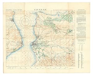
Chanak.
Published by Survey Department Egypt,, Cairo,, 1915
Seller: Antiquariaat FORUM BV, Houten, Netherlands
Seller rating 5 out of 5 stars
US$ 4,219.97
US$ 29.26 shipping
Ships from Netherlands to U.S.A.Quantity: 1 available
Add to basketThe finest contemporary map of the �anakkale sector of the Gallipoli Campaign, the site of the dreaded "Narrows" of the Dardanelles where allied naval forces made their ill-fated attempt to "force the straits" towards taking Istanbul, at a scale of 1:20,000. Drafted in Cairo under the direction of T. E. Lawrence (Lawrence of Arabia) at the Arab Bureau's Intelligence Office, based on a recently captured Ottoman map. The main map image is in black with land contours in brown, waterways in blue, and vegetation in green, with soundings printed in the strait and a grid of parallels and meridians in red (with a note that they are based on a magnetic north). The larger squares (each 5 x 5 smaller squares) are numbered (in a single sequence for the six maps in the series) and the 25 smaller squares designated by letters a-z (without e) - printed only in square 33, so that any 600 x 600 metre square on the map can be specified with coordinates.In the early days of World War I, the British and allied forces sought to knock the Ottoman Empire out of the conflict by taking Constantinople, by way of the Dardanelles. The Gallipoli Campaign (17 February 1915 to 9 January 1916) involved a force of 490,000 British, Indian, Australian, New Zealander and French troops making various landings upon the Gallipoli Peninsula that strategically guarded the mouth of the Dardanelles. The 325,000 Ottoman defenders, backed by German forces, successfully repelled these raids in one of the bloodiest military conflicts in world history.From the outset, the Allies were hampered by a lack of accurate maps of the Gallipoli Peninsula and the adjacent Asian shore of the Dardanelles. They eventually succeeded in capturing a complete six-part set of excellent, newly published Ottoman surveys showing the battle theatre in its entirety. These maps were rushed to the map department of the Intelligence Office (later the famed "Arab Bureau") in Cairo, where they were translated, enlarged and improved by a team headed by Lieutenant T. E. Lawrence, later known as "Lawrence of Arabia". These maps were printed by the Survey Department, Egypt, as a series of six interconnecting maps, although each map was designed to act as a stand-alone work complete in and of itself (a geographic key to all six maps is present on the back of the present map).Overall clean and bright, with some very light stains in the upper-left quadrant and light wear at some fold vertices.l Not in WorldCat. Folded. Colour-lithographed map (79 x 62.5 cm), printed in black, brown, red, blue and green. Mounted on contemporary cloth, with the key on the back (printed on or printed and pasted onto).
-

Chanak.
Published by Cairo, Survey Department, Egypt, 1915., 1915
Seller: Antiquariat INLIBRIS Gilhofer Nfg. GmbH, Vienna, A, Austria
Association Member: ILAB VDA VDAO
Seller rating 5 out of 5 stars
Colour lithograph, 790 x 625 mm. Mounted on original cloth with maps series key printed on verso. Folded. The finest contemporary map of the �anakkale sector of the Gallipoli Campaign, the site of the dreaded "Narrows" of the Dardanelles where Allied naval forces made their ill-fated attempt to "force the straits" towards taking Istanbul. Drafted in Cairo under the direction of T. E. Lawrence at the Arab Bureau's Intelligence Office, based on a recently captured Ottoman map. - In the early days of World War I, the Entente sought to knock the Ottoman Empire out of the conflict by taking Constantinople, by way of the Dardanelles. The Gallipoli Campaign (17 February 1915 to 9 January 1916) involved a force of 490,000 British, Indian, Australian, New Zealander and French troops making various landings upon the Gallipoli Peninsula that strategically guarded the mouth of the Dardanelles. The 325,000 Ottoman defenders, backed by German forces, successfully repelled these raids in what was one of the most bloody military contests in world history. - From the outset, the Allies were hampered by a lack of accurate maps of the Gallipoli Peninsula and the adjacent Asian shore of the Dardanelles. They eventually succeeded in capturing a complete six-part set of excellent, newly published Ottoman surveys showing the battle theatre in its entirety. These maps were rushed to the map department of the Intelligence Office (later the famed "Arab Bureau") in Cairo, where they were translated, enlarged and improved by a team headed by Lieutenant T. E. Lawrence, later known as "Lawrence of Arabia". These maps were printed by the Survey Department, Egypt, as a series of six interconnecting maps, although each map was designed to act as a stand-alone work complete in and of itself (a geographic key to all six maps is present on the verso of the present map). - Overall clean and bright, with some very light staining to upper-left quadrant and some light wear at some fold vertices.
-
![Seller image for Tension and peace in the Middle East : facts that every American should know about the tragedy of the Holy Land 1956 [LeatherBound] for sale by True World of Books](https://pictures.abebooks.com/inventory/md/md31657441098.jpg)
LeatherBound. Condition: New. BOOKS ARE EXEMPT FROM IMPORT DUTIES AND TARIFFS; NO EXTRA CHARGES APPLY. LeatherBound edition. Condition: New. Reprinted from 1956 edition. Leather Binding on Spine and Corners with Golden leaf printing on spine. Bound in genuine leather with Satin ribbon page markers and Spine with raised gilt bands. A perfect gift for your loved ones. Pages: 41 NO changes have been made to the original text. This is NOT a retyped or an ocr'd reprint. Illustrations, Index, if any, are included in black and white. Each page is checked manually before printing. As this print on demand book is reprinted from a very old book, there could be some missing or flawed pages, but we always try to make the book as complete as possible. Fold-outs, if any, are not part of the book. If the original book was published in multiple volumes then this reprint is of only one volume, not the whole set. Sewing binding for longer life, where the book block is actually sewn (smythe sewn/section sewn) with thread before binding which results in a more durable type of binding. Pages: 41 Palestine Arab Refugee Office.
-
![Seller image for Towards better understanding between the Arab world and the United States 1960 [LeatherBound] for sale by True World of Books](https://pictures.abebooks.com/inventory/md/md31618389969.jpg)
LeatherBound. Condition: New. BOOKS ARE EXEMPT FROM IMPORT DUTIES AND TARIFFS; NO EXTRA CHARGES APPLY. LeatherBound edition. Condition: New. Reprinted from 1960 edition. Leather Binding on Spine and Corners with Golden leaf printing on spine. Bound in genuine leather with Satin ribbon page markers and Spine with raised gilt bands. A perfect gift for your loved ones. Pages: 21 NO changes have been made to the original text. This is NOT a retyped or an ocr'd reprint. Illustrations, Index, if any, are included in black and white. Each page is checked manually before printing. As this print on demand book is reprinted from a very old book, there could be some missing or flawed pages, but we always try to make the book as complete as possible. Fold-outs, if any, are not part of the book. If the original book was published in multiple volumes then this reprint is of only one volume, not the whole set. Sewing binding for longer life, where the book block is actually sewn (smythe sewn/section sewn) with thread before binding which results in a more durable type of binding. Pages: 21.
-
![Seller image for Persecution of the Arabs in Israel ; Facts that every American should know about the tragedy of the Holy Land 1956 [LeatherBound] for sale by True World of Books](https://pictures.abebooks.com/inventory/md/md31618207944.jpg)
LeatherBound. Condition: New. BOOKS ARE EXEMPT FROM IMPORT DUTIES AND TARIFFS; NO EXTRA CHARGES APPLY. LeatherBound edition. Condition: New. Reprinted from 1956 edition. Leather Binding on Spine and Corners with Golden leaf printing on spine. Bound in genuine leather with Satin ribbon page markers and Spine with raised gilt bands. A perfect gift for your loved ones. Pages: 30 NO changes have been made to the original text. This is NOT a retyped or an ocr'd reprint. Illustrations, Index, if any, are included in black and white. Each page is checked manually before printing. As this print on demand book is reprinted from a very old book, there could be some missing or flawed pages, but we always try to make the book as complete as possible. Fold-outs, if any, are not part of the book. If the original book was published in multiple volumes then this reprint is of only one volume, not the whole set. Sewing binding for longer life, where the book block is actually sewn (smythe sewn/section sewn) with thread before binding which results in a more durable type of binding. Pages: 30.
-

Persecution of the Arabs in Israel; Facts That Every American Should Know About the Tragedy of the Holy Land
Language: English
Published by Hassell Street Press, 2021
ISBN 10: 1014279003 ISBN 13: 9781014279002
Seller: THE SAINT BOOKSTORE, Southport, United Kingdom
Seller rating 5 out of 5 stars
US$ 39.66
US$ 16.54 shipping
Ships from United Kingdom to U.S.A.Quantity: Over 20 available
Add to basketPaperback / softback. Condition: New. This item is printed on demand. New copy - Usually dispatched within 5-9 working days 156.
-
Tension and Peace in the Middle East: Facts That Every American Should Know About the Tragedy of the Holy Land
Language: English
Published by Hassell Street Press, 2021
ISBN 10: 1013698274 ISBN 13: 9781013698279
Seller: THE SAINT BOOKSTORE, Southport, United Kingdom
Seller rating 5 out of 5 stars
US$ 39.66
US$ 16.54 shipping
Ships from United Kingdom to U.S.A.Quantity: Over 20 available
Add to basketPaperback / softback. Condition: New. This item is printed on demand. New copy - Usually dispatched within 5-9 working days 156.
-
The Future of Palestine
Published by London The Arab Office, 1947
Seller: Fishburn Books ABA, ILAB, London, United Kingdom
Association Member: ABA ILAB PBFA
Seller rating 5 out of 5 stars
US$ 830.52
US$ 33.60 shipping
Ships from United Kingdom to U.S.A.Quantity: 1 available
Add to basketOriginal wrappers, 21cm., 166pp., text in English, wrappers slightly discoloured but overall in excellent condition. The contents of this book set out the problems with Palestine as perceived by the Arab Office, and then suggested solutions to these problems. This edition contains the appendices, some printing stop at page 89. This is the full edition OCLC 899097558.
-
![Seller image for [Transportation and communication map for the Egyptian region, United Arab Republic.] for sale by Geographicus Rare Antique Maps](https://pictures.abebooks.com/inventory/md/md32068518282.jpg)
[Transportation and communication map for the Egyptian region, United Arab Republic.]
Publication Date: 1960
Seller: Geographicus Rare Antique Maps, Brooklyn, NY, U.S.A.
Association Member: ABAA ESA ILAB
Seller rating 5 out of 5 stars
Map
Very good. Light wear along original folds. Size 36.5 x 25.5 Inches. A large-format c. 1960 map of Egypt under the ephemeral United Arab Republic by Abdel-Aal Mohammed Rashdan of the Cairo Drafting Office. It reflects the modernization drives of the Egyptian government led by Gamel Abdel Nasser. A Closer Look Covering the densely-populated Nile Delta, this map provides information on the country's geography and infrastructure. Provinces ( mudiriyah ??????) are color shaded for easy distinction. Paved roads, 'agricultural roads' (??? ??????), railways (main and secondary), towns and cities of various sizes and administrative functions, and airports are noted as indicated in the legend below the title. Important cultural and religious sites, including ancient Egyptian ruins, are represented pictorially and labeled, as are more recent economic projects, such as the Aswan Dam and an oil refinery near Suez. Circled numbers throughout correspond to an index of towns at the bottom-left. At left toward the top is a comprehensive table of distances between various settlements. At the bottom right is an inset map, a continuation of the main map along the course of the Nile. At the bottom left is an inset map of Egypt, officially the Egyptian region of the UAR, indicating roads from the Nile Delta to other parts of the country. The United Arab Republic The United Arab Republic (UAR), founded in 1958, was a political union between Egypt and Syria. It was a manifestation of pan-Arabism, a nascent ideology in the wake of the creation of the State of Israel and during the era of Arab countries declaring independence from the Western empires (Britain and France). The main catalyst for the UAR's creation was the 1956 Suez Crisis, in which Israel seized control of the Suez Canal with British and French support after Egyptian President Gamal Abdel Nasser nationalized it. The broader context of the Cold War also contributed to the creation of the United Arab Republic, as Communist influence in Syria was growing, and Syrian elites reluctantly agreed that a union with Egypt was the best means to prevent a Communist coup. Officially established on February 1, 1958, the new republic was quickly beset by disagreements between Nasser and Syrian elites, especially the Ba'ath Party, which he attempted to sideline. Although Nasser was extremely popular with the public throughout the Arab world, Syrians soon felt that outsiders were taking over their country. Thus, the union only lasted until 1961, when a coup d'�tat in Syria led to its secession. Egypt continued to be known as the UAR until 1971. More specifically related to the content of this map, whether as the Republic of Egypt or the United Arab Republic, Nasser aimed to invest heavily in Egypt's infrastructure. With lofty ambitions, his government undertook several large-scale projects, including new railways, highways, ports, and the Aswan High Dam, built in the 1960s with Soviet assistance. Some projects, such as shifting more of the population away from the Nile Delta to new interior settlements, did not pan out, but Nasser's years in power did leave the country with the modern infrastructure that it relies on today. Publication History and Census This map was prepared by cartographer Abdel-Aal Mohammed Rashdan (??? ????? ???? ?????) of the Cairo Drafting Office (???? ??????? ???????). It is undated, but the use of 'Egyptian region' of the UAR and other details (such as the absence of the Aswan High Dam) suggests a date between 1958 and 1961. The map is quite scarce, noted in the OCLC among the holdings of the American University in Cairo and Pennsylvania State University. It appears to be based on an earlier 1957 English-language edition of the map, which was then updated and reissued regularly until 1976. The present map, however, is an example of the only Arabic edition. References: OCLC 933755848.
-
[Maps of the Gallipoli Peninsula.]
Publication Date: 1915
Seller: Maggs Bros. Ltd ABA, ILAB, PBFA, London, United Kingdom
Association Member: ABA ILAB PBFA
Seller rating 5 out of 5 stars
Art / Print / Poster
US$ 10,381.45
US$ 36.28 shipping
Ships from United Kingdom to U.S.A.Quantity: 1 available
Add to basketFirst editions, first issues. Six colour lithograph maps measuring 630 by 785mm or �490 by 880mm. Scale 1 : 20,000. Very good copies mounted on linen with pin-holes from hanging, folded with a little staining. Cairo, Survey Department, Rare and important: a complete set of maps of the Gallipoli Peninsula produced under the direction of T.E. Lawrence in Cairo and based on captured Ottoman maps. � In June 1915, working on the basis of a partial set of maps found on a captured Turkish soldier, T.E. Lawrence?s Arab Bureau produced this series of six maps, each separately mapping the entire length of the Gallipoli Peninsula in a format designed to be issued to officers fighting in the field. � The maps are as follows: Kurija Dere; Bogali; Anarfarta Saghir; Chanak; Krithia; and Damler. � Of these, Kurija Dere (now Kocadere) is the most important, being an advanced topographical rendering of the Ari Burnu sector (named after the sea point located in the centre of the map), in the north-western part of the Gallipoli Peninsula. It was issued in the summer of 1915 while the Gallipoli campaign was still ongoing. It adds the toponyms Anzac Cove, Brighton Beach, Hell Spit, and Maclagan?s Ridge, while noting the critical battles of August, 1915: Lone Pine and Chunuk Bair. � The maps provide a clear understanding of the extreme difficulty that both the ANZACs and the Ottoman defenders faced while operating in such rugged territory. Soldiers often had to climb slopes of over 45� in gradient while enduring enemy fire. A series of red numbered grids, all orientated to the magnetic north to aid the use of the map in the field, have been added as Allied troops previously encountered severe orientation problems using the old maps of Gallipoli. The text panel to the right of the maps explains, in both English and French, how to use the grid reference as well as providing chart for converting feet to metres. A ?reference? translates Turkish topographical terms into English. � In the event that they were captured, the importance of these maps were such that officers were generally given only the sector relevant for them. While the campaign was vital to the history of both Australia and New Zealand, it also made the name of Ottoman Colonel Mustafa Kemal, better known as ?Atat�rk.? � The Gallipoli Campaign ran from 17 February, 1915 to 9 January, 1916 and involved a force of 490,000 Allied soldiers (British, Indian, Australian, New Zealand, and French troops) who were deployed in a series of landings along the Gallipoli Peninsula which was defended by 325,000 Ottoman troops. The Allies were hampered by misguided assumptions regarding the strength of Turkish forces, as well as poor geographic intelligence, notably relying on an Admiralty chart published in 1908 which was both inaccurate and at an unhelpful scale of 1 : 50,000, as well as a French map dating from the Crimean War. � While individual maps appear on the market from time to time, complete sets are very rare indeed. Brought together, they clarify the impossible demands of the entire campaign. � Oral, H., Gallipoli through Turkish Eyes (Istanbul, Bah�esehir University Press, 2012), pp.219-37.���������.
-
Turkey. Gallipoli.
Publication Date: 1915
Seller: Maggs Bros. Ltd ABA, ILAB, PBFA, London, United Kingdom
Association Member: ABA ILAB PBFA
Seller rating 5 out of 5 stars
Art / Print / Poster First Edition
US$ 3,460.48
US$ 36.28 shipping
Ships from United Kingdom to U.S.A.Quantity: 1 available
Add to basketFirst edition. Colour-printed map, measuring 505 by 675mm. Scale 1 : 250,000. Dissected and then backed on original linen, folded for use, ms. ink annotations. Cairo, Survey Department, A wonderful copy of this remarkable map of Gallipoli belonging to Lt. Eric Arundel Wilton dso, Signalling Officer of the 16th Battalion. Wilton went ashore on the first day of the landings and was invalided off the peninsula with a serious gunshot wound a week later. � � The map was originally produced by the British War Office in October 1908 (as is noted on the map itself) but this is the first wartime issue, specifically produced in Cairo for the use of the forces ashore at Gallipoli in 1915 by the map-making group headed by T.E. Lawrence. There was later a second issue, easily identified by the addition ?corrected to July 1915,? just before the major series of secondary landings in August. � � This is a medium-format map on a 1:250,000 scale, perhaps less well-known than the series of 1:20,000 maps of specific sites. The scale allows the map to take in the entire peninsula, from the landing sites on the western coast right across the peninsula to the dreamt-of destination at Gallipoli itself.� In addition to topographical information it denotes vegetation, water features, natural landmarks, populated places, and transport routes.� � The map has the ownership inscription of Wilton (1892?1932), a Victorian who enlisted into the AIF straight from the new Royal Military College at Duntroon, where he had been part of the first intake of June 1911. He was immediately appointed as a Lieutenant and Signalling Officer in the 16th Battalion, landing at Gallipoli on the first day. He was reported badly wounded on 1 May, although some sources, notably the account of the battle by the artist Ellis Silas (also a signaller in the 16th), suggest he had actually been carrying the wound for days. � � Given that Wilton was wounded and evacuated from Gallipoli within a week of the landing, never to return, the inference must be that this is the map issued to him as Signalling Officer for the landing: this would accord with the physical evidence on the verso, his name and ?copy no. 27? being added in ink ? clearly the map was only given out under very strict controls. Below these notes has been added a stamp for the ?4th Infantry Brigade? dated May 29, 1915 (perhaps it was in some sense checked off by the Brigade after his evacuation given the strategic information it contains?). That he retained the map can be seen from the fact that Wilton has added his rank of ?Major? to the inscription, a rank he did not attain until he was in France. � � After his evacuation, Wilton received treatment in Egypt, Malta and ? most unusually ? Florence before rejoining his battalion on the Western Front. Promoted to Major and transferred to one of the new Australian Machine Gun Companies, he saw action at Pozi�res in June 1916. Wounded a second time, he recuperated in England before being sent back to France in January 1917, initially with the 4th Machine Gun Company. He was promoted Brigade Major of the 4th Battalion in July, transferring to the 12th in the same role in October. His actions during Third Ypres, at Zonnebeke, in January 1918 led to him being awarded the Distinguished Service Order for his ?tenacious? work in organising the battalion?s defensive line in appalling weather while under heavy artillery fire. Twice Mentioned in Dispatches, Wilton was in a training position by the end of the war. � � After his return to Australia in March 1919 he was taken on the permanent staff of Duntroon as an instructor in tactics with a particular remit to study the use of mechanised vehicles. He died in a motorcycle accident in Kew in 1932. An obituary in the Melbourne papers hailed him as a ?mechanical genius.? He was buried with full military honours at Boroondara Cemetery.�.

![Seller image for The Expulsion Of The Palestine Arabs Fro Their Homeland : A Dark Page In Jewish History [Propaganda, Politics, Illustrated, History, Religion, Pov 1961, Commentary, Essay] for sale by GREAT PACIFIC BOOKS](https://pictures.abebooks.com/inventory/md/md31748639896.jpg)


![Seller image for [Maps of the Gallipoli Peninsula.] for sale by Maggs Bros. Ltd ABA, ILAB, PBFA](https://pictures.abebooks.com/inventory/md/md32265424689.jpg)
