Arctic Map (6 results)

- Hardcover
- Map
Seller: Geographicus Rare Antique Maps, Brooklyn, NY, U.S.A.Geographicus Rare Antique Maps
Contact seller4-star sellerHardcover. Very good. Original wash and outline color. Generous margins and a bold, sharp strike. Size 13.25 x 17.25 Inches. A fascinating and beautiful c. 1781 Philippe Buache map of the world, presented on an unusual north polar projection. This is the first work to attempt to map the ocean floor - a revolutionary work connect…ing undersea with surface geography. Although Buache's submarine geography was speculative at best, the work is a landmark achievement in its attempt to illustrate and scientifically assess the unknowable oceanic depths. Mapping the Ocean Floor This curious projection has its origins in a 1752 essay presented by Philippe Buache to the Royal Academy of Sciences in Paris. This paper, Essai de Geographie Physique , argued that the Earth's great river basins are defined by major mountain ranges, many of which extend beneath the oceans. These notions were more fully realized in Buache's 1757 physical atlas, Cartes et Tables De La Geographie Physique ou Naturelle , which was the first work to attempt the mapping of not only surface geological features but also the contours of the ocean floor. This map, in particular, supports the notion that physical features observable on land maintained continuity with areas covered in water. Thus, Buache's isolines that indicate gradients on land can be seen to do the same in the oceans, linking archipelagos and signaling the connectedness of the worlds' landmasses. Despite this mapping of the ocean floor being entirely speculative, Buache's map is a pioneering work in oceanographic cartography. Buache's mapping of sub-oceanic cartography was exceptionally challenging due to vast gaps in general geographical knowledge. Buache can only speculate on the southern continent of Antarctica. Cap de la Circoncision, now known to be part of Bouvet Island, is illustrated as a possible northern promontory of the Antarctic land mass. The mapping of Australia and Tasmania still relies on the 17th century explorations of Tasman. In support of his theories of undersea geography, Buache has added mountain ranges where none had yet been discovered. Some of these include speculative mountainous regions in the northern Sahara, bisecting central India, along the Orinoco basin, and connecting the islands of the Pacific. The Sea of the West Buache also includes a magnificent inland sea, called the Sea of the West or in this case the Mer de L'Ouest, in the northwestern part of North America. This body of water, alternatively called the Sea of the West or Baye de l'Ouest, was speculated by Philippe Buache and Nicholas De l'Isle in the early 18th century based upon wishful thinking, American Indian stories, and the somewhat questionable 16th century explorations of Juan de Fuca. Here Buache gives the Mer de l'Ouest its fullest expression, although he specifically does not connect it to either the factual network of lakes and rivers extending westward from the Hudson Bay or to the speculative De Fonte network just to the north. Other Details The map covers from the North Pole Arctic region south beyond Tasmania (Van Diemen's Land) to include parts of New Zealand and even Cap de la Circoncision (Bouvet Island). Color coding highlights different types of terrain with a key in the lower left quadrant. Extensive text expounding on Buache's geographical theories surround the map. Additional text describes the voyages of Bouvet de Lozier (1738-9) and Abel Tasman (1603-1659), both of which are marked on the map. Publication History and Census This map was originally issued in 1752. The present example was engraved in 1756 for inclusion in Buache's 1757 Cartes et Tables De La Geographie Physique ou Naturelle . The present example was included by Buache's successor, Jean-Claude Dezauche, in his 1781 Atlas Geographique . We see twelve examples of this map listed in institutional collections; it appears on the market in various editions from time to time. References: Rumsey 5698.003.
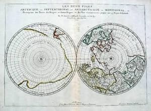
Published by Paris 1657
Seller: Antipodean Books, Maps & Prints, ABAA, Garrison, NY, U.S.A.Antipodean Books, Maps & Prints, ABAA
Contact seller3-star sellerPar N. Sanson d'Abbeville Geographe ordre du Roy. Spence 3017 lists a slightly different title but undoubtedly the same map. 53x38 cms. Period outline color, central fold, very good condition. A double hemisphere map to the North and South poles. The North pole is connected to Greenland and Spitzbergen but there is little other…detailed coastline in the polar area. Europe, Russia and Canada are delineated. The South pole is based on the great unknown Southland of Magellan. The tip of S. America is shown, and a large land mass which encompasses the whole of the hemisphere, but nothing else.

Seller: Herman H. J. Lynge & Søn ILAB-ABF, Copenhagen, , DenmarkHerman H. J. Lynge & Søn ILAB-ABF
Contact seller4-star sellerCondition: Used
US$ 79.76
US$ 48.62 shippingShips from Denmark to U.S.A.Quantity: 1 available
Calgarry - Alberta Canada, Symposium Committee, 1960. (102 x 115 cm.). Large colourprinted circular map of the Arctic Regions. Folded. Well-preserved.

- Map
Seller: Geographicus Rare Antique Maps, Brooklyn, NY, U.S.A.Geographicus Rare Antique Maps
Contact seller4-star sellerFair. Verso stabilization to centerfold split and adjacent tears, as well as points of oxidization from old color. Corner, upper left, reattached. Size 15.75 x 19.5 Inches. This is an old color example of Jan Jansson's c. 1650 map and nautical chart of Novaya Zemlya in the Russian Far North, which appeared in the fifth volume of… his Atlas Novus , also known as the 'Water World' atlas, the first true sea atlas. When this was issued, Novaya Zemlya was as hot in the European imagination as it was cold in fact. The archipelago was seen as a hopeful waypoint on the long-sought Northeastern Passage to Asia and was becoming increasingly popular with whalers. A Closer Look The map depicts the island of Nova Zembla or Nova Zemla in contemporary Western European sources, or Novaya Zemlya (????? ?????) in Russian, meaning 'new land,' located in the Russian Arctic. Coverage ranges from the Kola Peninsula (including the city of Kola or Murmansk) in the west to the Yenisei River in the east, with the main focus being on the island of Novaya Zemlya and the Russian mainland immediately opposite to the south. The Arctic Circle is marked prominently at 66.5° N latitude. Towns and settlements are named throughout, with navigational and topographic features also noted, especially along the coasts (shoals, bays, cliffs, islands, and so on). The chart includes two stunning compass roses, numerous rhumb lines, a sea monster, and ships. The title cartouche and additional cartouche at the bottom-right contain illustrations of local wildlife, human figures meant to be Russian trappers or Cossacks and members of the area's indigenous peoples, and an explanation of the latitude lines on the map, accounting for the curvature of the Earth towards the poles. The place names and textual explanations on the map are a combination of Dutch, Latin, and Romanized Russian (such as 'Mourmanskoy More'). A group of Dutch names on the Russian mainland just south of the island reflect that nation's commercial aspirations in the region: Straet von Nassau, Nieu Hollant, Nieu Walcheren, Nieu West Frieslant. Novaya Zemlya and the Search for a Northeast Passage Throughout the 16th and 17th centuries, the concept of a Northeast Passage through the Arctic to Asia held the same significance as North America's Northwest Passage. The nations of Northern Europe, particularly Russia and Holland, were eager to find an easy route to Asia via the Arctic to access the lucrative trade with China and India. Willem Barentsz's first expedition in 1594, in which he discovered Novaya Zemlya and several other Arctic islands, was widely publicized in Europe and led to the assumption that a Northeast Passage may indeed be feasible. His second voyage in 1595 was considered a truncated failure due to inclement weather and ice packs in the Kara Sea. A year later, his third voyage in 1596 was an utter disaster when the sailors were trapped by ice on the northern part of Novaya Zemlya. The crew somehow survived the winter in a small cabin (marked here) built from timber salvaged from their ship; when the weather warmed somewhat, Barentsz's men used the ship's remaining timber to build two smaller vessels that they expected would be able to navigate the ice better. A harrowing summertime journey of seven weeks cutting through ice along the coast of the island allowed some of the men to be rescued and return to Holland to tell the tale, though Barentsz himself perished. In 1871, the Norwegian seal hunter Elling Carlsen rediscovered Barentsz's cabin on Novaya Zemlya - perfectly preserved due to the Arctic cold. Publication History and Census This chart appeared in the fifth volume of Jansson's Atlas Novus , titled 'Atlantis Majoris Quinta Pars Orbem Maritimum.' (also known by its Dutch title 'Het Vijfde Deel Des Grooten Atlas, Vervatende De Water-Weereld'), commonly known as the 'Water World' atlas and constituting the first true sea atlas intended for a general audience. The blank verso here indicat.

Carte Des Terres aux environs du Japon ou du Nord-Est de l'Asie et du Nord-Ouest de l'Amerique Extraite d'une Carte Japonnoise de l'univer apportee en Europe par Kaempfer et depose dans le Cabinet de feu Mr. Hans-Sloane President de la Societe Rle. de Londres.
1758 Buache Map of the Arctic after Kaempfer (Considerations)
- Map
Seller: Geographicus Rare Antique Maps, Brooklyn, NY, U.S.A.Geographicus Rare Antique Maps
Contact seller4-star sellerVery good. Size 8.5 x 11.5 Inches. This is a rare 1758 map related to the Phillipe Buache / Robert de Vaugondy debate at the Paris Académie des Sciences over the cartographic configuration of the Pacific polar regions. This map was prepared for publication with Buache's Considerations Geographiques . A Closer Look Cartographical…ly Buache based this map on a Japanese map brought to Europe by the German traveler and physician Engelbert Kaempfer (1651 - 1716). Buache used the map to support his geographical theories regarding the Northwest Passage and Sea of the West. Kaempfer-Sloane Japanese Map of the World The Kaempfer-Sloane map was brought to Europe in manuscript from Japan in 1695 by Engelbert Kaempfer, a German traveler and physician. Hans Sloane acquired the map after Kaempfer's death. After Sloane's own death, it was liquidated at auction in London with the rest of his estate. The map illustrates Russian and Japanese knowledge of the North Atlantic. Today, it is heavily scrutinized by scholars who argue that it is likely a later compilation from European sources. At the time, it was an influential component in scholarly debates regarding the existence and location of the Northwest Passage. Buache created a variant of the map, as above, which he published in his Considerations Geographiques to support his synthesis and reconciliation of contemporaneous geographical information on the region. Buache / Robert de Vaugondy Polar Debate The Buache / Robert de Vaugondy debate at the Paris Académie des Sciences was one of the most hotly argued geographical debates of the 18th century. The debate centered around the existence of a 'Sea of the West,' the Northwest Passage, and the veracity of the Arctic explorations of Bartholomew de Fonte. In the 1750s, European knowledge of the Arctic and the Pacific Northwest was limited to the discoveries of Vitus Bering and Aleksei Ilyich Chirikov, the supposed voyage of de Fonte, and general geographical speculation. Buache was one of these speculators. Determined to win royal patronage, Buache leveraged the unpublished work (and fame) of his deceased brother-in-law, Guillaume De L'Isle, to promote his own geographical theories, most of which blatantly pandered to the crown. The Buache system drew heavily on the unpublished De L'Isle 'sea of the west' maps, Russian discoveries, the De Fonte geography, and his own framework, which postulated a series of interconnected global mountain ranges, to argue for a navigable northwest passage. Such a passage would have been a boon to French interests in North America as a way to move valuable furs and other trade goods to the rich markets of China - trade routes then primarily controlled by Spain. Buache fiercely defended his theories and in doing so came head to head with the more cautious cartography of Didier Robert de Vaugondy. Vaugondy was a thriving commercial cartographer and fellow member of the Académie des Sciences . His maps rejected the geographical theories, including the Sea of the West and the Northwest Passage, that Buache outlined in the Considerations Geographiques . Vaugondy also denounced the De Fonte voyages as unsubstantiated and doubtful, thereby deeply undermining Buache's theories and patronage ambitions. The debate came to a head in a series of papers published before the Académie by both individuals, wherein historical references, geographical theories, and outright speculation were used to advocate for their own hypotheses as well as denounce one another. There was no clear victor at the time, although Buache did emerge from the debate with greater political power and influence. Ironically, the expeditions of James Cook roughly 30 years later discredited Buache's theories. Publication History This map was issued as map VI in the Article CXV of the Mémoires pour l'Histoire des Sciences et des Beaux Arts , published by the Académie des Sciences in November 1758. The work constitutes the presentation of Philippe Buache o.

Septentrionalium Terrarum descriptio.
1595 First Edition Mercator Map of the Arctic (1st Map of the North Pole)
- First Edition
- Map
Seller: Geographicus Rare Antique Maps, Brooklyn, NY, U.S.A.Geographicus Rare Antique Maps
Contact seller4-star sellerCondition: Used
US$ 33,600.00
US$ 17.00 shippingShips within U.S.A.Quantity: 1 available
1st Edition. Very good. Generous margins. Minor corner reinstatement upper right - limited out outer margin. Size 15 x 16 Inches. This is the first edition, first state of Gerard Mercator's seminal 1595 map of the Arctic, the great cartographer's most interesting and important atlas map. In this first edition, it is the scarcest… of Mercator's atlas maps and a holy grail for any Arctic collector. For all its flaws and inaccuracies, it is a schematized interpretation of factual voyages between Norway, England, Iceland, Greenland, and Labrador (Markland). Context of this Polar Projection Mercator's Arctic projection has its roots in a magnificent 1569 wall map of the world in which Mercator first introduces his revolutionary projection. The difficulty with the Mercator Projection is that it dramatically inflates the appearance of size it draws near to the poles: its application to the polar regions themselves would result in an infinitely tall map. Mercator therefore included a polar projection, very similar to the map shown here, in the lower-left corner of his wall map. Mercator produced the present map, expanded and updated from his wall map, for inclusion in the first edition of his Atlas , published posthumously in 1595. As such, it is the first specific separate map of the Arctic. Taking it from the Top At the North Pole, Mercator depicts a large black rock, the Rupes Nigra , surrounded by a great whirlpool fed by four powerful rivers - 'the Indrawing Seas'. These divide a massive continent-sized landmass into four distinct islands. When the English polymath John Dee wrote to Mercator asking about his sources for this map, Mercator returned the following letter which survives in his own hand (April 20, 1577, British Library): In the midst of the four countries is a Whirl-pool, into which there empty these four indrawing Seas which divide the North. And the water rushes round and descends into the Earth just as if one were pouring it through a filter funnel. It is four degrees wide on every side of the Pole, that is to say eight degrees altogether. Except that right under the Pole there lies a bare Rock in the midst of the Sea. Its circumference is almost 33 French miles, and it is all of magnetic Stone () This is word for word everything that I copied out of this author years ago. The author to which Mercator referred is the Dutch traveler Jacobus Cnoyen van Tsertoghenbosche, whose report combined firsthand encounters with interpretations of an enigmatic lost work, the Inventio Fortunata (Fortunate Discoveries). This 14th century work, now largely forgotten, was a well-known resource for cartographers of the 15th and 16th centuries. The mysterious author may have been Nicholas of Lynn, Thomas Kingsbury, or Hugh of Ireland. The work told of a Minorite monk from Oxford who traveled extensively in northern lands, including Iceland, Greenland, Norway, and possibly even Labrador. The Inventio also cited far older lost works, the Principio Gestorum Arturi and the Leges Anglorum Londoniis Collectae , which contributed a chapter to the legend of King Arthur, casting him as a 6th century Arctic explorer, and describing Arthurian conquests of Iceland, Greenland, the Faeroes, parts of Norway, and even the North Pole. King Arthur - Arctic Explorer The Inventio described Arthur's invading Arctic army as consisting of some 4000 men on 12 ships. He sent the army into one of these 'indrawing seas', apparently the only way to bypass the 'Encircling Arctic Mountains'. According to John Dee, in Arthur's time there were cities lying beyond those mountains. Perhaps unsurprisingly, no further report of this momentous invasion appears in Arthurian record. In the fourteenth century, at the court of King Håkan Magnusson (1340 - 1380) in Norway, Cnoyen met and interviewed eight travelers from northern regions. One, a priest, even carried an astrolabe. Historian E. G. Taylor ('A letter dated 1577 from Mercator to John Dee.' Imago Mundi 13:5668) believed Cnoy.


