
Order Total (1 Item Items):
Shipping Destination:

Arnoldi Arnoldo (14 results)
Skip to main search results
Search filters
Product Type
- All Product Types
- Books (12)
- Magazines & Periodicals (No further results match this refinement)
- Comics (No further results match this refinement)
- Sheet Music (No further results match this refinement)
- Art, Prints & Posters (1)
- Photographs (No further results match this refinement)
- Maps (1)
- Manuscripts & Paper Collectibles (No further results match this refinement)
Condition Learn more
- New (No further results match this refinement)
- As New, Fine or Near Fine (No further results match this refinement)
- Very Good or Good (2)
- Fair or Poor (No further results match this refinement)
- As Described (12)
Binding
- All Bindings
- Hardcover (No further results match this refinement)
- Softcover (No further results match this refinement)
Collectible Attributes
- First Edition (1)
- Signed (No further results match this refinement)
- Dust Jacket (No further results match this refinement)
- Seller-Supplied Images (14)
- Not Print on Demand (14)
Language (1)
Price
- Any Price
- Under US$ 25 (No further results match this refinement)
- US$ 25 to US$ 50 (No further results match this refinement)
- Over US$ 50
Free Shipping
Seller Location
Seller Rating
-
De quaestionibus juris selectis. Libri duo
Published by Apud Angelum Fumi, Politiani, 1844
Seller: Libreria Antiquaria Giulio Cesare di Daniele Corradi, Roma, RM, Italy
Seller rating 2 out of 5 stars

VIII + 320 + (1) p. 222x143 mm.
-

Delle quistioni scelte di Arnoldo Vinnio recate in italiano e commentate per Antonio Rocchetti dottore in ambo le leggi
Published by Pei Tipi di Pietro Aureli 1842-1843, Ancona, 1842
Seller: Libreria Antiquaria Giulio Cesare di Daniele Corradi, Roma, RM, Italy
Seller rating 2 out of 5 stars
Mancanze e imperfezioni ai dorsi Opera completa in 2 volumi 755; 609 p. 2 voll 230x130 mm.
-
Tractatus quinque nempe de Pactis Jurisdictione Collationibus Transactionibus et Quaestionibus juris selectis. Cum Indicibus Locupletissimis. Quibus additae sunt Sim. Vinnii A.F. Orationes
Published by ex Typographia Balleoniana, Venetiis, 1780
Seller: Libreria Antiquaria Giulio Cesare di Daniele Corradi, Roma, RM, Italy
Seller rating 2 out of 5 stars
Sporadici percorsi di tarlo estinto VIII + 352 p. 245x200 mm.
-
In quatuor libros Institutionum Imperialium commentarius academicus et forensis
Published by Thomae Alphano, Neapoli, 1754
Seller: Libreria Antiquaria Giulio Cesare di Daniele Corradi, Roma, RM, Italy
Seller rating 2 out of 5 stars
Macchioline alle coperte, naturali bruniture sparse (14) + 568; 569-998 + (38) p. 4 voll in 2 tomi 245x185 mm.
-
In quatuor libros Institutionum Imperialium commentarius academicus et forensis. Jo. Gottl. Heineccius recensuit et Praefationem Natulasque adjecit. Accedunt in hac novissima editione juxta exemplar Lugdunense adornata ejusdem Vinnii Quaestiones juris selectae et praemittitur ex Editione Veneta Jacobi Gothofredi Historia et Bibliotheca Juris Civilis Romani
Published by ex Typographia Balleoniana, Venetiis, 1783
Seller: Libreria Antiquaria Giulio Cesare di Daniele Corradi, Roma, RM, Italy
Seller rating 2 out of 5 stars
Opera completa in 3 volumi con una tavola incisa a piena pagina XXXII + 536; IV + 452; VIII + 166 p. 3 voll in 2 tomi 260x220 mm.
-
In quatuor libros Institutionum Imperialium commentarius academicus et forensis Jo: Gottl. Heinnecius Jc. Recensuit, & Praefationem Notulasque adjecit
Published by Ex typographia Balleoniana, Venetiis, 1793
Seller: Libreria Antiquaria Giulio Cesare di Daniele Corradi, Roma, RM, Italy
Seller rating 2 out of 5 stars
Marginali, coevi pecorsi di tarlo estinto Opera completa in 2 volumi XXVIII + 459; IV + 387 con una tavola f.t. p. 2 voll 250x185 mm.
-

Delle quistioni scelte di Arnoldo Vinnio recate in italiano e commentate per Antonio Rocchetti
Published by Pei Tipi di Pietro Aureli 1842-1843, Ancona, 1842
Seller: Libreria Antiquaria Giulio Cesare di Daniele Corradi, Roma, RM, Italy
Seller rating 2 out of 5 stars
Opera completa in 2 volumi 755; 609 p. 2 voll in 1 tomo 220x145 mm.
-
In quatuor libros institutionum imperialium commentarius academicus et forensis. Editio quarta.
Published by Apud Danielem Elsevirium, Amstelodami, 1665
Seller: Libreria Antiquaria Giulio Cesare di Daniele Corradi, Roma, RM, Italy
Seller rating 2 out of 5 stars
Privo della prima bianca (12) + 888 + (20) p. 255x195 mm.
-
In quatuor libros Institutionum Imperialium commentarius academicus et forensis. Jo. Gottl. Heineccius recensuit et Praefationem Notulasque adjecit. Cui Jacobi Gothofredi J.C. Historia et Bibliotheca Juris Civilis romani praeponitur. Accedit etiam ad calcem Edictum perpetuum Salvii Juliani a Guglielmo Ranchino collectum. Editio novissima ceteris auctior et emendatior
Published by Typis Lucae Marotta, Neapoli, 1825
Seller: Libreria Antiquaria Giulio Cesare di Daniele Corradi, Roma, RM, Italy
Seller rating 2 out of 5 stars
Opera completa XL + 513 + (2); 514-997 p. 2 voll 260x215 mm.
-

In quatuor libros Institutionum Imperialium commentarius academicus & forensis
Published by Ex typographia Balleoniana, Venetiis, 1747
Seller: Libreria Antiquaria Giulio Cesare di Daniele Corradi, Roma, RM, Italy
Seller rating 2 out of 5 stars
Opera completa in 2 volumi (14) + 568; 569-998 + (2) p. 2 voll 230x175 mm.
-

Jurisprudentiae contractae sive partitionum juris civilis libri quatuor variis observationibus ad usum forensem accomodatis illustrati. Editio novissima ab erroribus qui in praecedentibus irrepserant diligenter expurgata
Published by ex Typographia Baelloniana, Venetiis, 1736
Seller: Libreria Antiquaria Giulio Cesare di Daniele Corradi, Roma, RM, Italy
Seller rating 2 out of 5 stars
XX + 515 p. 225x165 mm.
-
In quatuor libros institutionum imperialium commentarius academicus et forensis. Editio postrema, Authoris Notis, ante� seorsim impressis, aucta Titulorum concordantiis & Paragraphorum summulis adornata, � mendis purgata, adeoque emendatissima
Published by Ex Typographia P. & I. Blaev, Amstelodami, 1692
Seller: Libreria Antiquaria Giulio Cesare di Daniele Corradi, Roma, RM, Italy
Seller rating 2 out of 5 stars
Buono stato di conservazione (8) + 828 + (16) p. 255x200 mm.
-
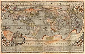
No binding. Condition: Very good. First. A RARE TWO-SHEET LAFRERI-SCHOOL WORLD MAP WITH ORIGINAL COLOR. Siena: Giovanni Florimi, 1634. Second issue. Two sheets (32 1/4" x 20 3/8", 816mm x 523mm sheet). Engraved, with original hand-coloring. Framed floating with glass recto and verso (39 3/4" x 28 1/2"). A stadium map of the world, with scrollwork in the corners. The whole is surrounded by a white-on-black heraldic meander. At the top, the title. At the bottom, a description in four columns. At the lower left of the map, a cartouche with the arms of Federico Borromeo (il Giovane). Backed onto a sheet, evening out some irregular margins. Two vertical lines of soiling from earlier folds. Two areas restored in facsimile: ONDO in the title with its corresponding border, and a triangular section north of China centered on Tanguth. Some small patches of abrasion, but altogether in excellent shape, and with vivid original hand-color. The Lafreri School takes its name from Antonio Lafreri (1512-1577), the Burgundian cartographer-engraver who settled in Rome and who embarked on the method of compiling atlases from loose sheets printed by various engravers and cartographers, based on the interest of a particular client. This practice would become popular throughout the continent in the XVIIc. Lafreri-School maps represent the high-water-mark of Italian cartography before the center of mapmaking moved north to the Netherlands. Arnoldo di Arnoldi (d. 1602), a Belgian transplant to Italy, went to work for Matteo Florimi (1540-1615), whose son Giovanni continued the business after his death as Eredi Florimi (Florimi's Heirs). Arnoldi brought influences from further afield to Italian mapmaking; in the case of our map, the 1592 eighteen-sheet cylindrical map of 1592 (which survives in a single copy at the Colegio del Corpus Christi in Valencia) made by Petrus Plancius. Arnoldi's ten-sheet map (1600) was the first to draw on that map. In 1601, Arnoldi reduced the map to two sheets; our map is the second state of that 1601 two-sheet map (of which Bifolco-Ronca cites only five copies). The original state was dedicated to Cristoforo Chigi, the 1634 state to Federico Borromeo (1617-1673), who in that year (at the age of 17) received his doctorate in civil and canon law from the University of Siena. The map is notable cartographically. It includes the Strait of Ani�n, the hypothesized precursor to the Bering Strait, as well as Lake Conibas, a clustered lake generalizing the Great Lakes, drawn from Mercator's 1569 map. Indeed, Mercator's influence is strongly felt throughout the map. The North Pole is in four islands, and there is a magnetic node near the Strait of Ani�n, which is perhaps an early explanation of magnetic variance. Most striking of course is the terra australe incognita that fills nearly half of the southern hemisphere. It is connected to the southern tip of South America in the western hemisphere and joins to Giava Minore (i.e., Sumatra), which had been mentioned by Marco Polo and erroneously positioned on maps for centuries by scribal error; the connection of Sumatra to the terra australis was made by Jean Alfonse in 1544 and persisted into the XVIIc despite exploration by Janszoon and others. Bifolco-Ronca, pp. 296-297; Shirley, Mapping of the World 228.
-

Condition: ACEPTABLE. Mapa muy raro de Arnoldo di Arnoldini; cartografo y grabador que trabajo en Italia aprincipios del siglo XVII; primero en Bologna con Giovanni Antonio Magini y luego en Siena con Matteo Florimi. Firmaba pocos de los mapas que realizo; el mas importante es el mapa mundi mural, en 10 hojas basado en el de Petrus Plancius del que quedan muy pocos ejemplares. Es el segundo ejempar que tenemos de este raro mapa de espa�a, el anterior lo vendimos a la Biblioteca naciona de espa�a en los a�os setenta. Ejemplar limpio, restaurado expertamenteen dos peque�as partes del norte del mapa. Formato (cm): 47x36.