B C Hydro (9 results)

- Hardcover
Seller: Hourglass Books, vancouver, BC, CanadaHourglass Books
Contact seller5-star sellerCondition: Used - Very good
US$ 75.00
Free ShippingShips from Canada to U.S.A.Quantity: 1 available
Hardcover. Condition: Very Good+. Very Good+, Not Price Clipped. Canadian First. Complete number line from 1 to 5; minor wear; otherwise a solid, clean copy with no marking or underlining; collectible condition; well illustrated with both black and white and colour photographs. Book.

- Hardcover
- First Edition
Seller: RareNonFiction, IOBA, Ladysmith, BC, CanadaRareNonFiction, IOBA
Contact seller5-star sellerCondition: Used - Very good
US$ 169.95
US$ 19.99 shippingShips from Canada to U.S.A.Quantity: 1 available
Hardcover. Condition: Very Good. Dust Jacket Condition: Very Good. First Edition. 236 pages. Index. Chronology. Profusely illustrated with archival black and white photos. ". The history begins in the 1860s when gas lamps first illuminated the streets of Victoria, and runs until the present era of billion-watt (gigawatt) power p…rojects." - from dust jacket. Clean and unmarked with light wear. A nice copy.

Published by B.C. Hydro Power Authority, Vancouver, BC 1973
- Softcover
Seller: Harropian Books, IOBA, Nelson, BC, CanadaHarropian Books, IOBA
Contact seller5-star sellerCondition: Used
US$ 61.91
US$ 22.00 shippingShips from Canada to U.S.A.Quantity: 1 available
Paperback. Condition: Very Near Fine. Side stapled printed card wraps, 4to (11 inches [27.9 cm] tall), pp. (i) [submission letter], 21, 2 fold-out color maps. Front cover with a few pink a dots and rubber stamp, else unmarked. A report outlining BC Hydro's need for a 500 kilovolt transmission line between Kootenay Canal and the…North Okanagan in British Columbia, Canada. See Kootenaiana #169.

Published by B.C. Hydro Power Authority, Vancouver, BC 1973
- Softcover
Seller: Harropian Books, IOBA, Nelson, BC, CanadaHarropian Books, IOBA
Contact seller5-star sellerCondition: Used - Fine
US$ 61.91
US$ 22.00 shippingShips from Canada to U.S.A.Quantity: 1 available
Paperback. Condition: Fine. Side stapled printed card wraps, 4to (11 inches [27.9 cm] tall), pp. (i) [submission letter], 28, three maps, one being a fold-out at rear. Front cover with a faint ink stamp, else unmarked. A report outlining BC Hydro's need for a 230 kilovolt transmission line between Kootenay Canal generating plant… and Kimberly in British Columbia, Canada, completing the link between Kootenay Canal and Cranbrook. Not found in Kootenaiana, but similar to #169.

Published by B.C. Hydro, British Columbia 1965
- Softcover
- First Edition
Seller: RareNonFiction, IOBA, Ladysmith, BC, CanadaRareNonFiction, IOBA
Contact seller5-star sellerCondition: Used - Very good
US$ 69.95
US$ 19.99 shippingShips from Canada to U.S.A.Quantity: 1 available
Paperback. Condition: Very Good. First Edition. Twelve page stapled booklet. Contains recipes ranging from Beef Stroganoff to Tomato Toppers to Broccoli Parmesan and Cherry Orange Bread. Undated but appears to be circa 1965. Clean and unmarked with light wear. A quality copy of this nostalgic piece of B.C. Hydro ephemera.; 8vo.

Published by B.C. Hydro, British Columbia 1980
- Softcover
- First Edition
Seller: RareNonFiction, IOBA, Ladysmith, BC, CanadaRareNonFiction, IOBA
Contact seller5-star sellerCondition: Used - Very good
US$ 99.95
US$ 19.99 shippingShips from Canada to U.S.A.Quantity: 1 available
Plastic Comb. Condition: Very Good. First Edition. 22 pages plus 6 large, detailed fold-out maps. Summary volume of a report entitled 'Corridor and Route Nomination for Vancouver Island Natural Gas System' which described B.C. Hydro's proposed project to provide natural gas service to Vancouver Island residents and industry. Exp…lains the reasons for nomination of a preferred corridor, and preferred route within that corridor, for a natural gas pipeline to and on Vancouver Island. This summary provides basic technical, environmental, and land use information on the routing B.C. Hydro nominated. Contents include: Introduction - Natural Gas for Vancouver Island; Reasons for the Project; Initial Route Studies; Corridor Nomination; Route Nomination; Public Consultation. Maps entitle: Existing Natural Gas Fields and Transmission Lines in B.C.; Major options for Gas Transmission System to Serve Southwestern B.C.; Bathymetry of Georgia Strait and Other Features Affecting Location of Submarine Pipelines; Factors Affecting Corridor Location; Proposed Gas Distribution Areas; Important Environmental Concerns with Nominated Corridor and Route. Unmarked. Very light wear. Excellent copy.

- Hardcover
- Print on Demand
Seller: True World of Books, Delhi, , IndiaTrue World of Books
Contact seller5-star sellerLeatherBound. Condition: New. BOOKS ARE EXEMPT FROM IMPORT DUTIES AND TARIFFS; NO EXTRA CHARGES APPLY. LeatherBound edition. Condition: New. Reprinted from 1982 edition. Leather Binding on Spine and Corners with Golden leaf printing on spine. Bound in genuine leather with Satin ribbon page markers and Spine with raised gilt band…s. A perfect gift for your loved ones. Pages: 24 NO changes have been made to the original text. This is NOT a retyped or an ocr'd reprint. Illustrations, Index, if any, are included in black and white. Each page is checked manually before printing. As this print on demand book is reprinted from a very old book, there could be some missing or flawed pages, but we always try to make the book as complete as possible. Fold-outs, if any, are not part of the book. If the original book was published in multiple volumes then this reprint is of only one volume, not the whole set. Sewing binding for longer life, where the book block is actually sewn (smythe sewn/section sewn) with thread before binding which results in a more durable type of binding. Pages: 24.

- Hardcover
- Print on Demand
Seller: True World of Books, Delhi, , IndiaTrue World of Books
Contact seller5-star sellerLeatherBound. Condition: New. BOOKS ARE EXEMPT FROM IMPORT DUTIES AND TARIFFS; NO EXTRA CHARGES APPLY. LeatherBound edition. Condition: New. Reprinted from 1980 edition. Leather Binding on Spine and Corners with Golden leaf printing on spine. Bound in genuine leather with Satin ribbon page markers and Spine with raised gilt band…s. A perfect gift for your loved ones. Pages: 22 NO changes have been made to the original text. This is NOT a retyped or an ocr'd reprint. Illustrations, Index, if any, are included in black and white. Each page is checked manually before printing. As this print on demand book is reprinted from a very old book, there could be some missing or flawed pages, but we always try to make the book as complete as possible. Fold-outs, if any, are not part of the book. If the original book was published in multiple volumes then this reprint is of only one volume, not the whole set. Sewing binding for longer life, where the book block is actually sewn (smythe sewn/section sewn) with thread before binding which results in a more durable type of binding. Pages: 22.
 More images
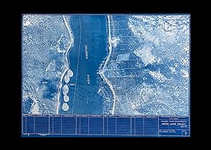
Published by B.C. Hydro, British Columbia 1960
Seller: Harropian Books, IOBA, Nelson, BC, CanadaHarropian Books, IOBA
Contact seller5-star sellerCondition: Used
US$ 236.72
US$ 22.00 shippingShips from Canada to U.S.A.Quantity: 1 available
Sheet Map. Condition: At Least Very Good. Sheet No. 7 - with "Hunting Survey Corporation Limited / West Coast Division" printed at lower left margin - in B.C. Hydro's Columbia River Developments : Arrow Lakes series having "Date of Photography June-July, 1960" stated at bottom right hand corner. Large photo map has a scale of 1…inch to 200 feet, so offers an excellent view of the properties about to be flooded near Robson, B.C. Note that the "Columbia River" is now designated as Lower Arrow Lake on most maps. A circa 1960 Aerial Photo-Map of Robson, B.C. measuring overall, 26 inches tall x 35-3/8 inches wide, the printed area within the single border/neat line measures 25 inches tall x 24-1/4 inches wide. Map with light edge wear and a few short closed tears, else clean and unmarked. Previously rolled. This aerial photo was produced by BC Hydro prior to the construction of the Hugh Keenleyside Dam (originally named the High Arrow Dam) the photos were then made into maps showing predicted flood elevations, propertry lines and where the flood levels would rise to after closing the gates. A large, historic aerial photo that allows many family properties to be seen prior to being submerged. "Originally two lakes 14 miles apart, the Arrow Lakes became one 230 km long lake due to the reservoir created by the 1960s construction of the Keenleyside Dam; at low water the two lakes remain distinct, connected by a fast-moving section known as the Narrows. Damming the Lower Arrow Lake resulted in water rising 12 metres above natural levels. As a result of higher water, the valley lost 2/3 of its arable land. Thousands of people relocated." wiki accessed 04/21.


