Baltimore Map (5 results)
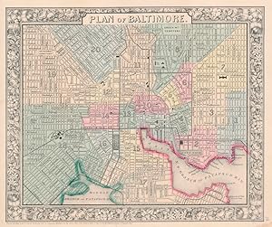
Published by S. Augustus Mitchell, Jr., New York 1860
- Map
Seller: Main Street Fine Books & Mss, ABAA, Galena, IL, U.S.A.Main Street Fine Books & Mss, ABAA
Contact seller5-star sellerFolio (15¼" X 12¼", image area 11" X 9¼"). Hand colored. Very good. Light age toning, some minor soiling and small stain at lower right margin. Well colored example of this detailed city plan, from the 1864 edition of "Mitchell's New General Atlas, Containing Maps of the Various Countries of the World, Plans of Cities, Etc." Nic…e floral border and overall a charming rendition of "Charm City.".
 More images
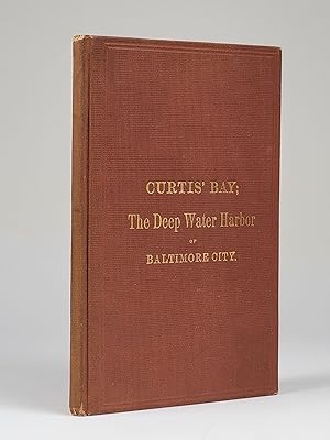
Published by The Patapsco Land Company, Baltimore 1874
- Hardcover
- First Edition
Seller: Back Creek Books LLC, ABAA/ILAB, Annapolis, MD, U.S.A.Back Creek Books LLC, ABAA/ILAB
Contact seller5-star sellerHardcover. Octavo. 100 pages. First edition. This is a detailed prospectus seeking investment in the newly reorganized Patapsco Land Company, which intended to turn its holdings at Curtis Bay into a major seaport and railhead. The background information included therefore gives much of interest relating to the evolution of shipp…ing and railroads at Baltimore. The large map in a rear pocket shows the planned layout of the city of Pennington, named for the PLC's controlling family. A copy of this prospectus was even delivered to the U.S. House of Representatives in hopes of getting buy-ins from major players in the shipping and railroad industries, which would be essential for the plan to succeed. Alas, despite the seemingly solid plan and convincing sales pitch, the PLC could not get sufficient capital together to pull it off. And thus there is no town of Pennington, Maryland today. Bound in brick red cloth over boards with upper board titled in gilt. A few light extremity rubs. Slight age-toning inside. Map has a few short clean separations at fold intersections. Fine condition overall. Large fold-out map (illustrator).

Published by S. Augustus Mitchell, Jr., New York 1860
- Map
Seller: Main Street Fine Books & Mss, ABAA, Galena, IL, U.S.A.Main Street Fine Books & Mss, ABAA
Contact seller5-star sellerFolio (15¼" X 12¼", image area 11" X 9¼"). Hand colored. Very good. Bit of age toning. A nice, clean (and clean-edged) example of this detailed city plan, from the 1864 edition of "Mitchell's New General Atlas, Containing Maps of the Various Countries of the World, Plans of Cities, Etc." Attractive decorative floral border and w…ell-done original coloring.

A Map of Johns Hopkins Hospital attempting to show the general plan, HABITS of the STAFF, STUDENTS, and PATIENTS, curious CUSTOMS etc. and so forth.
1935 Yardley Satirical Pictorial Map of Johns Hopkins, Baltimore, Maryland
- Map
Seller: Geographicus Rare Antique Maps, Brooklyn, NY, U.S.A.Geographicus Rare Antique Maps
Contact seller4-star sellerGood. Even overall toning. Size 13.25 x 10.25 Inches. This is a 1935 Richard Q. Yardley pictorial map of Johns Hopkins Hospital in Baltimore, Maryland. A fantastic illustration of the original Administration Building occupies the lower portion of the map and immediately draws the eye. From there, the hospital's various wards, cl…inics, and buildings are illustrated. Many of the illustrations are comical in nature. A researcher standing atop a large microscope is mocked by a germ in the General Pathology Department, while a researcher stares at question marks under a microscope in the research lab. Three nurses are shocked by a patient's temperature in the Osler Medical Clinic and a 'patient on the mend' watches the annual Turtle Derby. (The Turtle Derby was still an annual event as of 2015. It began in 1931 as a way to entertain the children at the Children's Clinic.) A surgeon to the right of the Administration Building attempts to operate on a shocked patient with a large knife. A pictorial border surrounds the hospital's campus on three sides and identifies local hangouts, shops, and other buildings related to the university, including Welch Library and Fraternity Row. 'A studious young gentleman' sits atop a pile of books near Welch Library, while a young couple awaiting a baby brought by a stork marks housing for married interns. A Politically Incorrect Piece While satirical in nature, some of Yardley's jokes have not aged well, many of which are sexist and/or racist. On the left, a doctor stares at the x-ray of a female patient's torso as she exclaims, 'Oh Doctor!'. Another joke involving nurses appears just below the title when one nurse asks another, 'Did you come to get or forget?' In the lower-left corner of the border, the nurse's quarters are marked by a primping nurse and the phrase, 'Here ye Beauteous Nurses do Reside' and next door a nude nurse lounges in the solarium, much to the shock of a passing bird. Publication History and Census This map was created by Richard Q. Yardley and published in 1935. We note a single cataloged example (David Rumsey Map Collection). This map is very rare on the private market, as we note only two other instances when it has appeared. References: Rumsey 11432.000. Not in OCLC.
 More images
- Map
Seller: Geographicus Rare Antique Maps, Brooklyn, NY, U.S.A.Geographicus Rare Antique Maps
Contact seller4-star sellerVery good. Blank on verso. Accompanied by original mailer. Size 19.25 x 15.25 Inches. This is a c. 1935 Richard Yardley pictorial map of Baltimore County, Maryland. Populated by comical caricatures of the county's residents, Yardley both mocks and celebrates its history. Many of these vignettes illustrate historical events, such… as the county's founding, its involvement in the American Revolution, the War of 1812, and the American Civil War. Baltimore itself does not appear on the map since it was separated from the county in 1851. Yardley acknowledges the role Native Americans played, stating that many of the modern-day county roads started as Indian trails. The other side of the coin was that Fort Garrison, near Pikesville, was built as a defense against those same Indians. Joppa occupies a sizable portion of the map, with its bustling trade with England and the West Indies prominently touted. A banner also states that the city was the county seat in 1712. Antebellum America Yardley also doesn't shy away from the horrors of Antebellum America. He references slavery twice, although neither is as cutting as would have been hoped. Two upper-class people meet in the upper right corner (near the decorative compass rose), and the man states, 'I do not wish to impose,' to which the woman responds, 'My many slaves make it no problem.' The second reference appears on the lower left, next to a very wealthy gentleman dressed in his finest clothes, who states that 'many loving slaves help me in my labors' while 'ye loving slaves' are illustrated in the shadows toiling away, utterly indistinguishable from one another. Publication History and Census This map was created by Richard Yardley and published c. 1935. An example is part of the David Rumsey Map Collection. It does not appear in OCLC. References: Rumsey 11708.002.


