
Order Total (1 Item Items):
Shipping Destination:

Bart Metselaar (16 results)
Skip to main search results
Search filters
Product Type
- All Product Types
- Books (16)
- Magazines & Periodicals (No further results match this refinement)
- Comics (No further results match this refinement)
- Sheet Music (No further results match this refinement)
- Art, Prints & Posters (No further results match this refinement)
- Photographs (No further results match this refinement)
- Maps (No further results match this refinement)
- Manuscripts & Paper Collectibles (No further results match this refinement)
Condition Learn more
- New (16)
- As New, Fine or Near Fine (No further results match this refinement)
- Very Good or Good (No further results match this refinement)
- Fair or Poor (No further results match this refinement)
- As Described (No further results match this refinement)
Binding
- All Bindings
- Hardcover (No further results match this refinement)
- Softcover (9)
Collectible Attributes
- First Edition (No further results match this refinement)
- Signed (No further results match this refinement)
- Dust Jacket (No further results match this refinement)
- Seller-Supplied Images (6)
- Not Print on Demand (16)
Language (1)
Price
- Any Price
- Under US$ 25
- US$ 25 to US$ 50 (No further results match this refinement)
- Over US$ 50 (No further results match this refinement)
Free Shipping
Seller Location
Seller Rating
-

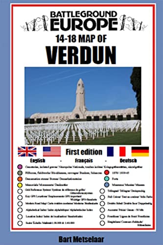
Verdun (Map)
Language: English
Published by Pen and Sword Books Ltd, GB, 2020
ISBN 10: 1526768208 ISBN 13: 9781526768209
Paperback. Condition: New. For many years the Holts have provided tourers to the battlefields with excellent mapping for the Ypres Salient and the Somme. This map of the Verdun/Meuse area fills one of the many gaps in the coverage of the Western Front.This map of the Verdun battlefield is in the same style, using a colour coded system to distinguish the different types of features. It includes some 300 locations of memorials, cemeteries, significant remnants of the battle terrain, remaining fortifications, trenches, the destroyed villages and other vestiges of the war. On the reverse there is a cut out and enlarged section of the Verdun battlefield in particular - the most visited part of the area, which provides greater detail. This section includes the Ossuary at Douamont, Forts Douamont, Vaux and Souville and many more features. The front line at key stages of the battle in 1916 is clearly indicatedGPS references are given for the more signifiant sites. Roads and major tracks are shown, with restrictions in access as known at the date of publication.The map extends from the eastern fringes of the Argonne Forest to the west and encompasses the whole of the 1916 Verdun battlefield to the east. This means that several places of interest to the student of the American army's offensive in late 1918 are shown.The map is tri-lingual - in English, French and German - so far as is practicable given the constraints of space. The map is of a manageable size, both in a vehicle and when being used outside.
-

Verdun (Map) (Paperback)
Language: English
Published by Pen & Sword Books Ltd, South Yorkshire, 2020
ISBN 10: 1526768208 ISBN 13: 9781526768209
Paperback. Condition: new. Paperback. For many years the Holts have provided tourers to the battlefields with excellent mapping for the Ypres Salient and the Somme. This map of the Verdun/Meuse area fills one of the many gaps in the coverage of the Western Front. This map of the Verdun battlefield is in the same style, using a colour coded system to distinguish the different types of features. It includes some 300 locations of memorials, cemeteries, significant remnants of the battle terrain, remaining fortifications, trenches, the destroyed villages and other vestiges of the war. On the reverse there is a cut out and enlarged section of the Verdun battlefield in particular - the most visited part of the area, which provides greater detail. This section includes the Ossuary at Douamont, Forts Douamont, Vaux and Souville and many more features. The front line at key stages of the battle in 1916 is clearly indicated GPS references are given for the more signifiant sites. Roads and major tracks are shown, with restrictions in access as known at the date of publication. The map extends from the eastern fringes of the Argonne Forest to the west and encompasses the whole of the 1916 Verdun battlefield to the east. This means that several places of interest to the student of the American army's offensive in late 1918 are shown. The map is tri-lingual - in English, French and German - so far as is practicable given the constraints of space. The map is of a manageable size, both in a vehicle and when being used outside. AUTHOR: Bart Metselaar has been visiting the battlefields of the Western Front for over twenty years, from his late teens. He has spent much time walking the battlefields of the Western Front and has acquired an encyclopaedic knowledge of the ground and the surviving remnants of the war. An amateur cartographer, he has produced the mapping for a number of Pen and Sword Battleground Europe books. He has been working on this Verdun map for some years, painstakingly searching out memorials that have been all but forgotten. He is now turning his attention to the Arras battlefield. 1 colour map Comprehensive mapping for the Battle of Verdun 1916 and a sizeable part of the early days of the Meuse-Argonne Offensive 1918. Clearly produced in full colour, with different types of feature in different colours, all supported by two comprehensive keys. Shipping may be from multiple locations in the US or from the UK, depending on stock availability.
-

Arras (Map) (Paperback)
Language: English
Published by Pen & Sword Books Ltd, South Yorkshire, 2022
ISBN 10: 1526796309 ISBN 13: 9781526796301
Paperback. Condition: new. Paperback. For many years the Holts have provided tourers to the battlefields with excellent practical mapping for the Ypres Salient and the Somme. This map of the Arras area, following the publication of Verdun in this series of Battleground Europe maps, fills one of the gaps in the coverage of the Western Front. This map of the Arras battlefield is in the same style, using a colour coded system to distinguish the different types of features. It includes over 200 locations of memorials, cemeteries, significant remnants of the battle terrain, remaining fortifications, trenches, and other vestiges of the war. It provides locations associated with many personalities, including VC winners and of the site of mine craters (some of which still exist) in the Vimy area. The front line at key stages of the war is clearly indicated GPS references are given for the more signifiant sites. Roads and major tracks are shown. High ground that was of importance in the fighting is clearly indicated. On the reverse there are enlarged sections of parts of the battlefield of notable importance, such as Notre Dame de Lorette, the northern end of Vimy Ridge (associated with the Canadian Corps) and the city of Arras. The map extends from just north of Notre Dame de Lorette to south of Bullecourt. To the east it includes, for example, Vis en Artois and Haucourt and to the west Ballacourt, Maroeuil and Mont St Eloi. The map is bi-lingual (in English and French) so far as is practicable and given the constraints of space. The map is of a manageable size, both in a vehicle and when being used outside on the ground. This is the second (following Verdun) of the maps that Bart has designed and produced of an important Great War conflict zone on the Western Front. Bart Metselaar has been visiting the battlefields of the Western Front for over twenty years, from his late teens. He has spent much time walking the battlefields of the Western Front and has acquired an encyclopaedic knowledge of the ground and the surviving remnants of the war. An amateur cartographer, he has produced the mapping for a number of Pen and Sword 'Battleground Europe' books. He worked on his first map, on the Verdun battlefield (2020) for some years, painstakingly searching out memorials that have been all but forgotten and working to design a map that could provide and place a wealth of information on the ground. He is now turning his attention to the French Flanders battlefield. 1 colour map Comprehensive mapping for the Battle of Arras 1917 and a sizeable part of the Battles of Artois 1914-1915. Shipping may be from multiple locations in the US or from the UK, depending on stock availability.
-
Condition: New. Brand New.
-
Verdun (Map)
Language: English
Published by Pen and Sword Books Ltd, 2020
ISBN 10: 1526768208 ISBN 13: 9781526768209
Seller: PBShop.store UK, Fairford, GLOS, United Kingdom
Seller rating 5 out of 5 stars

PAP. Condition: New. New Book. Shipped from UK. Established seller since 2000.
-
Verdun (Map) (Battleground Europe Maps)
Language: English
Published by Pen and Sword Military, 2020
ISBN 10: 1526768208 ISBN 13: 9781526768209
Condition: New.
-
US$ 11.69
US$ 16.81 shipping
Ships from United Kingdom to U.S.A.Quantity: 1 available
Add to basketPaperback. Condition: Brand New. map edition. 8.39x5.59x0.08 inches. In Stock.
-
Verdun (Map) (Battleground Europe Maps)
Language: English
Published by Pen and Sword Military, 2020
ISBN 10: 1526768208 ISBN 13: 9781526768209
Seller: Ria Christie Collections, Uxbridge, United Kingdom
Seller rating 5 out of 5 stars
US$ 11.61
US$ 16.11 shipping
Ships from United Kingdom to U.S.A.Quantity: 4 available
Add to basketCondition: New. In.
-
Verdun (Map)
Language: English
Published by Pen & Sword Books Ltd, 2020
ISBN 10: 1526768208 ISBN 13: 9781526768209
Seller: Kennys Bookshop and Art Galleries Ltd., Galway, GY, Ireland
Seller rating 5 out of 5 stars
Condition: New. 2020. Map. . . . . .
-
Verdun (Map)
Language: English
Published by Pen & Sword Books Ltd, 2020
ISBN 10: 1526768208 ISBN 13: 9781526768209
Condition: New. 2020. Map. . . . . . Books ship from the US and Ireland.
-
Arras (Map) (Paperback)
Language: English
Published by Pen & Sword Books Ltd, South Yorkshire, 2022
ISBN 10: 1526796309 ISBN 13: 9781526796301
Paperback. Condition: new. Paperback. For many years the Holts have provided tourers to the battlefields with excellent practical mapping for the Ypres Salient and the Somme. This map of the Arras area, following the publication of Verdun in this series of Battleground Europe maps, fills one of the gaps in the coverage of the Western Front. This map of the Arras battlefield is in the same style, using a colour coded system to distinguish the different types of features. It includes over 200 locations of memorials, cemeteries, significant remnants of the battle terrain, remaining fortifications, trenches, and other vestiges of the war. It provides locations associated with many personalities, including VC winners and of the site of mine craters (some of which still exist) in the Vimy area. The front line at key stages of the war is clearly indicated GPS references are given for the more signifiant sites. Roads and major tracks are shown. High ground that was of importance in the fighting is clearly indicated. On the reverse there are enlarged sections of parts of the battlefield of notable importance, such as Notre Dame de Lorette, the northern end of Vimy Ridge (associated with the Canadian Corps) and the city of Arras. The map extends from just north of Notre Dame de Lorette to south of Bullecourt. To the east it includes, for example, Vis en Artois and Haucourt and to the west Ballacourt, Maroeuil and Mont St Eloi. The map is bi-lingual (in English and French) so far as is practicable and given the constraints of space. The map is of a manageable size, both in a vehicle and when being used outside on the ground. This is the second (following Verdun) of the maps that Bart has designed and produced of an important Great War conflict zone on the Western Front. Bart Metselaar has been visiting the battlefields of the Western Front for over twenty years, from his late teens. He has spent much time walking the battlefields of the Western Front and has acquired an encyclopaedic knowledge of the ground and the surviving remnants of the war. An amateur cartographer, he has produced the mapping for a number of Pen and Sword 'Battleground Europe' books. He worked on his first map, on the Verdun battlefield (2020) for some years, painstakingly searching out memorials that have been all but forgotten and working to design a map that could provide and place a wealth of information on the ground. He is now turning his attention to the French Flanders battlefield. 1 colour map Comprehensive mapping for the Battle of Arras 1917 and a sizeable part of the Battles of Artois 1914-1915. Shipping may be from our Sydney, NSW warehouse or from our UK or US warehouse, depending on stock availability.
-

Verdun (Map) (Paperback)
Language: English
Published by Pen & Sword Books Ltd, South Yorkshire, 2020
ISBN 10: 1526768208 ISBN 13: 9781526768209
Paperback. Condition: new. Paperback. For many years the Holts have provided tourers to the battlefields with excellent mapping for the Ypres Salient and the Somme. This map of the Verdun/Meuse area fills one of the many gaps in the coverage of the Western Front. This map of the Verdun battlefield is in the same style, using a colour coded system to distinguish the different types of features. It includes some 300 locations of memorials, cemeteries, significant remnants of the battle terrain, remaining fortifications, trenches, the destroyed villages and other vestiges of the war. On the reverse there is a cut out and enlarged section of the Verdun battlefield in particular - the most visited part of the area, which provides greater detail. This section includes the Ossuary at Douamont, Forts Douamont, Vaux and Souville and many more features. The front line at key stages of the battle in 1916 is clearly indicated GPS references are given for the more signifiant sites. Roads and major tracks are shown, with restrictions in access as known at the date of publication. The map extends from the eastern fringes of the Argonne Forest to the west and encompasses the whole of the 1916 Verdun battlefield to the east. This means that several places of interest to the student of the American army's offensive in late 1918 are shown. The map is tri-lingual - in English, French and German - so far as is practicable given the constraints of space. The map is of a manageable size, both in a vehicle and when being used outside. AUTHOR: Bart Metselaar has been visiting the battlefields of the Western Front for over twenty years, from his late teens. He has spent much time walking the battlefields of the Western Front and has acquired an encyclopaedic knowledge of the ground and the surviving remnants of the war. An amateur cartographer, he has produced the mapping for a number of Pen and Sword Battleground Europe books. He has been working on this Verdun map for some years, painstakingly searching out memorials that have been all but forgotten. He is now turning his attention to the Arras battlefield. 1 colour map Comprehensive mapping for the Battle of Verdun 1916 and a sizeable part of the early days of the Meuse-Argonne Offensive 1918. Clearly produced in full colour, with different types of feature in different colours, all supported by two comprehensive keys. Shipping may be from our Sydney, NSW warehouse or from our UK or US warehouse, depending on stock availability.
-

Verdun (Map) (Paperback)
Language: English
Published by Pen & Sword Books Ltd, South Yorkshire, 2020
ISBN 10: 1526768208 ISBN 13: 9781526768209
US$ 13.80
US$ 49.76 shipping
Ships from United Kingdom to U.S.A.Quantity: 1 available
Add to basketPaperback. Condition: new. Paperback. For many years the Holts have provided tourers to the battlefields with excellent mapping for the Ypres Salient and the Somme. This map of the Verdun/Meuse area fills one of the many gaps in the coverage of the Western Front. This map of the Verdun battlefield is in the same style, using a colour coded system to distinguish the different types of features. It includes some 300 locations of memorials, cemeteries, significant remnants of the battle terrain, remaining fortifications, trenches, the destroyed villages and other vestiges of the war. On the reverse there is a cut out and enlarged section of the Verdun battlefield in particular - the most visited part of the area, which provides greater detail. This section includes the Ossuary at Douamont, Forts Douamont, Vaux and Souville and many more features. The front line at key stages of the battle in 1916 is clearly indicated GPS references are given for the more signifiant sites. Roads and major tracks are shown, with restrictions in access as known at the date of publication. The map extends from the eastern fringes of the Argonne Forest to the west and encompasses the whole of the 1916 Verdun battlefield to the east. This means that several places of interest to the student of the American army's offensive in late 1918 are shown. The map is tri-lingual - in English, French and German - so far as is practicable given the constraints of space. The map is of a manageable size, both in a vehicle and when being used outside. AUTHOR: Bart Metselaar has been visiting the battlefields of the Western Front for over twenty years, from his late teens. He has spent much time walking the battlefields of the Western Front and has acquired an encyclopaedic knowledge of the ground and the surviving remnants of the war. An amateur cartographer, he has produced the mapping for a number of Pen and Sword Battleground Europe books. He has been working on this Verdun map for some years, painstakingly searching out memorials that have been all but forgotten. He is now turning his attention to the Arras battlefield. 1 colour map Comprehensive mapping for the Battle of Verdun 1916 and a sizeable part of the early days of the Meuse-Argonne Offensive 1918. Clearly produced in full colour, with different types of feature in different colours, all supported by two comprehensive keys. Shipping may be from our UK warehouse or from our Australian or US warehouses, depending on stock availability.
-

Verdun (Map)
Language: English
Published by Pen and Sword Books Ltd, GB, 2020
ISBN 10: 1526768208 ISBN 13: 9781526768209
Paperback. Condition: New. For many years the Holts have provided tourers to the battlefields with excellent mapping for the Ypres Salient and the Somme. This map of the Verdun/Meuse area fills one of the many gaps in the coverage of the Western Front.This map of the Verdun battlefield is in the same style, using a colour coded system to distinguish the different types of features. It includes some 300 locations of memorials, cemeteries, significant remnants of the battle terrain, remaining fortifications, trenches, the destroyed villages and other vestiges of the war. On the reverse there is a cut out and enlarged section of the Verdun battlefield in particular - the most visited part of the area, which provides greater detail. This section includes the Ossuary at Douamont, Forts Douamont, Vaux and Souville and many more features. The front line at key stages of the battle in 1916 is clearly indicatedGPS references are given for the more signifiant sites. Roads and major tracks are shown, with restrictions in access as known at the date of publication.The map extends from the eastern fringes of the Argonne Forest to the west and encompasses the whole of the 1916 Verdun battlefield to the east. This means that several places of interest to the student of the American army's offensive in late 1918 are shown.The map is tri-lingual - in English, French and German - so far as is practicable given the constraints of space. The map is of a manageable size, both in a vehicle and when being used outside.
-
Arras (Map) (Paperback)
Language: English
Published by Pen & Sword Books Ltd, South Yorkshire, 2022
ISBN 10: 1526796309 ISBN 13: 9781526796301
US$ 17.30
US$ 49.76 shipping
Ships from United Kingdom to U.S.A.Quantity: 1 available
Add to basketPaperback. Condition: new. Paperback. For many years the Holts have provided tourers to the battlefields with excellent practical mapping for the Ypres Salient and the Somme. This map of the Arras area, following the publication of Verdun in this series of Battleground Europe maps, fills one of the gaps in the coverage of the Western Front. This map of the Arras battlefield is in the same style, using a colour coded system to distinguish the different types of features. It includes over 200 locations of memorials, cemeteries, significant remnants of the battle terrain, remaining fortifications, trenches, and other vestiges of the war. It provides locations associated with many personalities, including VC winners and of the site of mine craters (some of which still exist) in the Vimy area. The front line at key stages of the war is clearly indicated GPS references are given for the more signifiant sites. Roads and major tracks are shown. High ground that was of importance in the fighting is clearly indicated. On the reverse there are enlarged sections of parts of the battlefield of notable importance, such as Notre Dame de Lorette, the northern end of Vimy Ridge (associated with the Canadian Corps) and the city of Arras. The map extends from just north of Notre Dame de Lorette to south of Bullecourt. To the east it includes, for example, Vis en Artois and Haucourt and to the west Ballacourt, Maroeuil and Mont St Eloi. The map is bi-lingual (in English and French) so far as is practicable and given the constraints of space. The map is of a manageable size, both in a vehicle and when being used outside on the ground. This is the second (following Verdun) of the maps that Bart has designed and produced of an important Great War conflict zone on the Western Front. Bart Metselaar has been visiting the battlefields of the Western Front for over twenty years, from his late teens. He has spent much time walking the battlefields of the Western Front and has acquired an encyclopaedic knowledge of the ground and the surviving remnants of the war. An amateur cartographer, he has produced the mapping for a number of Pen and Sword 'Battleground Europe' books. He worked on his first map, on the Verdun battlefield (2020) for some years, painstakingly searching out memorials that have been all but forgotten and working to design a map that could provide and place a wealth of information on the ground. He is now turning his attention to the French Flanders battlefield. 1 colour map Comprehensive mapping for the Battle of Arras 1917 and a sizeable part of the Battles of Artois 1914-1915. Shipping may be from our UK warehouse or from our Australian or US warehouses, depending on stock availability.
-

Verdun (Map)
Language: English
Published by Pen & Sword Books Nov 2020, 2020
ISBN 10: 1526768208 ISBN 13: 9781526768209
Karte. Condition: Neu. Neuware - Comprehensive mapping for the Battle of Verdun 1916 and a sizable part of the early days of the Meuse-Argonne Offensive 1918. Clearly produced in full color, with different types of feature in different colors, all supported by two comprehensive keys.For many years the Holts have provided tourers to the battlefields with excellent mapping for the Ypres Salient and the Somme. This map of the Verdun/Meuse area fills one of the many gaps in the coverage of the Western Front.This map of the Verdun battlefield is in the same style, using a color coded system to distinguish the different types of features. It includes some 300 locations of memorials, cemeteries, significant remnants of the battle terrain, remaining fortifications, trenches, the destroyed villages and other vestiges of the war. On the reverse there is a cut out and enlarged section of the Verdun battlefield in particular - the most visited part of the area, which provides greater detail. This section includes the Ossuary at Douamont, Forts Douamont, Vaux and Souville and many more features. The front line at key stages of the battle in 1916 is clearly indicated.GPS references are given for the more significant sites. Roads and major tracks are shown, with restrictions in access as known at the date of publication.The map extends from the eastern fringes of the Argonne Forest to the west and encompasses the whole of the 1916 Verdun battlefield to the east. This means that several places of interest to the student of the American army's offensive in late 1918 are shown.The map is trilingual - in English, French and German - so far as is practicable given the constraints of space. The map is of a manageable size, both in a vehicle and when being used outside.