Battle Plan (13 results)
 More images
Doniphan's Expedition; Containing an Account of the Conquest of New Mexico; General Kearney's Overland Expedition to California; Doniphan's Campaign Against the Navajos; His Unparalleled March Upon Chihuahua and Durango; And the Operations of General Price at Santa Fe: With a Sketch of the Life of Col. Doniphan. (1914 'SENATE DOCUMENT' REPRINT)
Hughes, John T., A.B., of the First Regiment of Missouri Cavalry.
Language: English
Published by Government Printing Office, Washington 1914
- Hardcover
Seller: Cat's Curiosities, Pahrump, NV, U.S.A.Cat's Curiosities
Contact seller4-star sellerCondition: Used - Fair
US$ 27.50
US$ 6.00 shippingShips within U.S.A.Quantity: 1 available
Hardcover. Condition: Fair. No Jacket. Half cordovan leather over red pebbled boards; red marbled side and bottom page edges and glossy endpapers; ex-library with manila card-holder to rear and five-digit serial number stamped to top corner of FFE, RFE and second title page but otherwise free of library stampings. Attachment of…the front board is fragile, reducing our grade from "good ex-library" to "fair." Although the SECOND title page here is the 1847 U.P. James Cincinnati title page (so dated to verso), the FIRST title page identifies this as Document No. 608 of the 2d Session of the 63rd Congress, presented by Mr. Stone on May 26, 1914, and reported by Mr. Chilton to the Committee on Printing October 21,1914, "Resolved, That the pamphlet submitted by Mr. Stone on May 26, 1914, entitled 'Doniphan's Expedition,'" etc., "be printed as a Senate document, with accompanying illustrations." 202 pp. This is NOT the longer account (with very similar title) of William Elsey Connelley, published by Bryant and Douglas Book and Stationery Co, Kansas City, Missouri, in 1907. That one includes a frontispiece photographic portrait and a folding map of Mexico and the Western Unites States. (No map, here.) Reduced from $62. Illustrated with Plans of Battle Fields and Fine Engravings (though the B&W illustrations are small and integrated with the text, with only the Plan of the Battle of Sacramento occupying a full page.) (illustrator).
Published by Silas Andrus, Hartford 1817
- Hardcover
Seller: Frogtown Books, Inc. ABAA, Toledo, OH, U.S.A.Frogtown Books, Inc. ABAA
Contact seller4-star sellerLaBaume was Captain of the Royal Geographical Engineers; Ex-Officer of the Ordnance of Prince Eugene; Chevalier of the Legion of Honour, and of the Iron Crown, Author of an Abridged History of the Republic of Venice. Endpapers and prelims foxed. Bookplate of Robert H. Folger on front pastedown. Leather sturdy but rubbed. Leather… at top of spine chipped away about 3/8" from top. 8vo. with original leather binding.355 pp. including Itinerary and List of Names. Engraved frontispiece portrait of Napoleon. Two fold-out maps. However, the Plan of the Field of Battle of Moskwa Sept 7 1812 is half missing. But, the Plan of the Field of Battle of Malo-Jaroslavetz, 24 Oct. 1812. is complete. It is split half way u (illustrator).

PLAN OF THE SECOND BATTLE OF SERBRAXOS, Fought 20 May 1772 - an Original Antique Engraving
PLAN OF THE SECOND BATTLE OF SERBRAXOS, Fought 20 May 1772 - an Original Antique Engraving
Language: English
Seller: K Books Ltd ABA ILAB, York, YORKS, United KingdomK Books Ltd ABA ILAB
Contact seller5-star sellerCondition: Used - Very good
US$ 20.71
US$ 26.14 shippingShips from United Kingdom to U.S.A.Quantity: 1 available
No Binding. Condition: Very Good. An original antique engraving, printed 1804. Mounted (matted) and ready to frame. Very good condition. An engraving of the battle plan, based round Tedda and Gondar. Heath (illustrator).
PLAN OF THE THIRD BATTLE OF SERBRAXOS, Fought 23 May 1772 - an Original Antique Engraving
PLAN OF THE THIRD BATTLE OF SERBRAXOS, Fought 23 May 1772 - an Original Antique Engraving
Language: English
Seller: K Books Ltd ABA ILAB, York, YORKS, United KingdomK Books Ltd ABA ILAB
Contact seller5-star sellerCondition: Used - Very good
US$ 20.71
US$ 26.14 shippingShips from United Kingdom to U.S.A.Quantity: 1 available
No Binding. Condition: Very Good. An original antique engraving, printed 1804. Mounted (matted) and ready to frame. Very good condition. An engraving of the battle plan, based round Tedda and the Mountains of Belessen. Heath (illustrator).
PLAN OF THE FIRST BATTLE OF SERBRAXOS, Fought 16 May 1771 - an Original Antique Engraving
PLAN OF THE FIRST BATTLE OF SERBRAXOS, Fought 16 May 1771 - an Original Antique Engraving
Language: English
Seller: K Books Ltd ABA ILAB, York, YORKS, United KingdomK Books Ltd ABA ILAB
Contact seller5-star sellerCondition: Used - Very good
US$ 20.71
US$ 26.14 shippingShips from United Kingdom to U.S.A.Quantity: 1 available
No Binding. Condition: Very Good. An original antique engraving, printed 1804. Mounted (matted) and ready to frame. Very good condition. An engraving of the battle plan, based round Tedda and Gondar. Heath (illustrator).
Language: English
Seller: K Books Ltd ABA ILAB, York, YORKS, United KingdomK Books Ltd ABA ILAB
Contact seller5-star sellerCondition: Used - Very good
US$ 34.52
US$ 26.14 shippingShips from United Kingdom to U.S.A.Quantity: 1 available
No Binding. Condition: Very Good. An original antique hand coloured engraving. Hand colouring not contemporary but expertly and delicately executed. Mounted - matted - and ready to frame. Very good condition - a splendid plan - shows the Battle of Fontenoy.
MAP OF THE BATTLE OF THE NILE, BAY OF ABOUKIR, AUGUST 1, 1798
PLAN OF THE BATTLE OF THE NILE, 1798. An Original, Antique, Hand-Coloured Map.
Language: English
Seller: K Books Ltd ABA ILAB, York, YORKS, United KingdomK Books Ltd ABA ILAB
Contact seller5-star sellerCondition: Used - Very good
US$ 34.52
US$ 26.14 shippingShips from United Kingdom to U.S.A.Quantity: 1 available
No Binding. Condition: Very Good. Antique plan . Hand coloured, engraved map. mounted - matted - and ready to frame .7.5 x 6 inches. An attractive decorative hand coloured antique map. . A splendid map, colouring not contemporary but delicately and expertly done - a fine plan of the Battle of the Nile, August 1st 1798 at 8 o'clo…ck in the evening. SIDNEY HALL (illustrator).
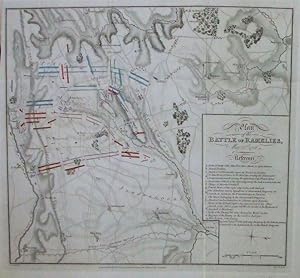
PLAN of the SITUATION where the BATTLE of RAMILLIES was FOUGHT May ye 23.d 1706: Designed upon the Spot by G.L.Mosburger, Officer in General Dopf's Regiment of Dragoons - Original Antique Hand-Coloured Copper-engraved Plan
PLAN of the SITUATION where the BATTLE of RAMILLIES was FOUGHT May ye 23.d 1706: Designed upon the Spot by G.L.Mosburger, Officer in General Dopf's Regiment of Dragoons - Original Antique Hand-Coloured Copper-engraved Plan
Language: English
Seller: K Books Ltd ABA ILAB, York, YORKS, United KingdomK Books Ltd ABA ILAB
Contact seller5-star sellerCondition: Used - Very good
US$ 110.48
US$ 26.14 shippingShips from United Kingdom to U.S.A.Quantity: 1 available
No Binding. Condition: Very Good. Hand-coloured Copper engraved plan, mounted (matted) and ready to frame in the UK, but for overseas customers it would probably be unmounted as it would be too large to post. Colouring not contemporary, but delicately and expertly done. No date, but printed c 1750. A Plan of the Situation where…the Battle of Ramillies was fought May ye 23 rd 1706: Designed upon the Spot by G.L.Mosburger, Officer in General Dopf's Regiment of Dragoons. Printed for Mr Tindal's continuation of Mr Rapin's History of England. Basire (illustrator).
PLAN OF THE BATTLE OF OUDENARD FOUGHT JULY 11th 1708 - Original Antique Hand-Coloured Copper-engraved Plan
PLAN OF THE BATTLE OF OUDENARD FOUGHT JULY 11th 1708 - Original Antique Hand-Coloured Copper-engraved Plan
Language: English
Seller: K Books Ltd ABA ILAB, York, YORKS, United KingdomK Books Ltd ABA ILAB
Contact seller5-star sellerCondition: Used - Very good
US$ 110.48
US$ 26.14 shippingShips from United Kingdom to U.S.A.Quantity: 1 available
No Binding. Condition: Very Good. Hand-coloured Copper engraved plan, mounted (matted) and ready to frame in the UK, but for overseas customers it would probably be unmounted as it would be too large to post. Colouring not contemporary, but delicately and expertly done. No date, but printed c 1750. Plan of the battle of Oudenard…, with the explanation of the battle inset. Printed for Mr Tindal's continuation of Mr Rapin's History of England. Basire (illustrator).
- Art Print
Seller: Antiquariat Martin Barbian & Grund GbR, Saarbruecken, , GermanyAntiquariat Martin Barbian & Grund GbR
Contact seller5-star sellerCondition: Used
US$ 29.80
US$ 52.07 shippingShips from Germany to U.S.A.Quantity: 1 available
Kupferstich von Neele & Son bei Longman, Hurst, Rees & Orne, 1818, 24x31 cm, mit farbig eingezeichneten Truppenstellungen (Faltspuren) (Landkarten / Belgien / Antique Maps / Belgium).
- Art Print
Seller: Antiquariat Martin Barbian & Grund GbR, Saarbruecken, , GermanyAntiquariat Martin Barbian & Grund GbR
Contact seller5-star sellerCondition: Used
US$ 35.76
US$ 52.07 shippingShips from Germany to U.S.A.Quantity: 1 available
Kupferstich von Neele & Son bei Longman, Hurst, Rees & Orne, 1818, 31x33 cm, mit farbig eingezeichneten Truppenstellungen (Faltspuren) (Landkarten / Belgien / Antique Maps / Belgium).
 More images
Published by [London?, 1816
Seller: Antiquariaat FORUM BV, Houten, , NetherlandsAntiquariaat FORUM BV
Contact seller5-star sellerCondition: Used
US$ 2,085.85
US$ 28.93 shippingShips from Netherlands to U.S.A.Quantity: 1 available
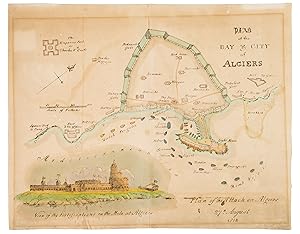
Contemporary hand coloured lithographed(?) plate with the plan for the Bombardment of Algiers in August 1816. The attack was instigated and won by Great Britain and the Netherlands, which was celebrated in London.The Bombardment of Algiers was part of a European campaign to end piracy against Europeans by North African countries…. The goal of this attack was to free Christian slaves in Algeria and stop Omar Agha (?-1817), the of Dey of Algiers, from enslaving more Europeans. The attack was partly successful. Algeria freed around 3000 Christian slaves after the battle, but did not stop enslaving Europeans until later in the 19th century.The plan for the attack was made by Admiral Lord Exmouth, the commander of the fleet. The largest ships approached the harbour in a column, sailed to the zone were the Algerian guns could not reach them, and bombarded the defences. Other ships blocked the harbour, to attack the Algerian ships and prevent them from joining the battle. On the present illustration, each of the British ships is named and drawn in its planned position, thus giving an interesting visual insight into 19th-century naval tactics.The sheet is folded in half, with a tear along the top and bottom of the fold, somewhat browned and stained, with remnants of tape on the back. The plan and view remain clear and the colouring remains bright. With an illustration of the plan of attack and a view of the fortifications on the Mole at Algiers.

La Veritable Description du Siege de Philipsbourg par les Francois.
1734 Hendrik de Leth Battle Plan or Map of the Siege of Philippsburg, Germany
- Map
Seller: Geographicus Rare Antique Maps, Brooklyn, NY, U.S.A.Geographicus Rare Antique Maps
Contact seller4-star sellerVery good. Light wear along original centerfold. Closed margin tears professionally repaired on verso. Size 18.25 x 19.25 Inches. This is the 1734 Hendrik de Leth battle plan or map of the siege of Philippsburg in modern-day Baden-Württemberg, Germany. A fortified city along the Rhine, Philippsburg was contested between the Fren…ch and Germans since 1644. A Closer Look Detailing Philippsburg's fortifications on both sides of the Rhine, letters identify French and German positions around with a key situated in the upper left. French cavalry and French Swiss regiments are marked by text, as are French entrenchments to rebuff the Imperial attack and relieve the siege. The French bridges across the Rhine are labeled as well ( Deux Pont de Vaisseaux François ). The Siege of Philippsburg The Siege of Philippsburg (June 2 - July 18, 1734) occurred during the War of the Polish Succession (1733 - 1735) and was the second siege of the city in the previous fifty years. The siege lasts for over a month, with the French fighting off a relief effort led by Prince Eugene of Savoy. The French breached the first line of defense on July 17, reaching the citadel's ramparts, and the city surrendered the following day. The War of the Polish Succession The War of the Polish Succession (October 10, 1733 - October 3, 1735) was a major European war ignited by the Polish Civil War over the succession of King Augustus II of Poland. France, Spain, and the Kingdom of Prussia fought to test the power of the Austrian Habsburgs, while Russia and Saxony fought to support the eventual successor. After two years of war, with most of the associated military campaigns fought outside of Poland, Augustus III ascended to the throne, with the support of the Habsburgs, Russia, and Saxony. Although fighting ended in 1735, the Treaty of Vienna that formally ended the war was not signed until 1738. Augustus III was formally recognized as king, and his rival, Stanis?aw Leszczy?ski, was awarded two fiefs within the Holy Roman Empire: the Duchy of Bar and the Duchy of Lorraine. The war resulted in several duchies and fiefdoms changing hands and, more importantly, it was disastrous for Polish independence. There would only be one more Polish king, Stanis?aw August Poniatowski (who was a Russian puppet) before Poland was divided amongst its neighbors in the First Partition of Poland. Publication History and Census This map was created and published by Hendrick de Leth in 1734. We note four cataloged examples which are part of the collections at the Bibliothèque nationale de France, the Royal Collection Trust, the Bibliotheek Universiteit van Amsterdan, and the Newberry Library. References: Bibliothèque nationale de France, département Cartes et plans, GE C-3428. Royal Collection Trust RCIN 727056. OCLC 71533863, 954483249.


