Benchmark Maps Atlases (29 results)

- Softcover
Seller: The Book Files, Broken Arrow, OK, U.S.A.The Book Files
Contact seller5-star sellerCondition: Used - Good
US$ 9.50
US$ 5.49 shippingShips within U.S.A.Quantity: 1 available
Soft cover. Condition: Good. WE SHIP DAILY. Book has a little corner wear. ***PROMPT PROFESSIONAL SERVICE!***.
Seller: World of Books (was SecondSale), Montgomery, IL, U.S.A.World of Books (was SecondSale)
Contact seller5-star sellerCondition: Used - Good
US$ 12.08
Free ShippingShips within U.S.A.Quantity: 1 available
Condition: Good. Item in good condition. Textbooks may not include supplemental items i.e. CDs, access codes etc.

Seller: Goodwill of Colorado, COLORADO SPRINGS, CO, U.S.A.Goodwill of Colorado
Contact seller5-star sellerCondition: Used - Good
US$ 15.54
Free ShippingShips within U.S.A.Quantity: 1 available
Condition: good. All pages and cover are intact. Dust jacket included if applicable, though it may be missing on hardcover editions. Spine and cover may show minor signs of wear including scuff marks, curls or bends to corners as well as cosmetic blemishes including stickers. Pages may contain limited notes or highlighting. "Fro…m the library of" labels may be present. Shrink wrap, dust covers, or boxed set packaging may be missing. Bundled media e.g., CDs, DVDs, access codes may not be included. Benchmark Maps (illustrator).
Seller: World of Books (was SecondSale), Montgomery, IL, U.S.A.World of Books (was SecondSale)
Contact seller5-star sellerCondition: Used - Good
US$ 16.25
Free ShippingShips within U.S.A.Quantity: 1 available
Condition: Good. Item in good condition. Textbooks may not include supplemental items i.e. CDs, access codes etc.
Seller: HPB Inc., Dallas, TX, U.S.A.HPB Inc.
Contact seller5-star sellerCondition: Used - Very good
US$ 12.61
US$ 3.75 shippingShips within U.S.A.Quantity: 1 available
map. Condition: Very Good. Connecting readers with great books since 1972! Used books may not include companion materials, and may have some shelf wear or limited writing. We ship orders daily and Customer Service is our top priority. Benchmark Maps (illustrator).
Seller: PBShop.store US, Wood Dale, IL, U.S.A.PBShop.store US
Contact seller5-star sellerCondition: New
US$ 18.33
Free ShippingShips within U.S.A.Quantity: 3 available
UNK. Condition: New. New Book. Shipped from UK. Established seller since 2000.
Seller: PBShop.store UK, Fairford, GLOS, United KingdomPBShop.store UK
Contact seller5-star sellerCondition: New
US$ 17.93
US$ 4.41 shippingShips from United Kingdom to U.S.A.Quantity: 3 available
UNK. Condition: New. New Book. Shipped from UK. Established seller since 2000.
Seller: California Books, Miami, FL, U.S.A.California Books
Contact seller4-star sellerCondition: New
US$ 24.00
Free ShippingShips within U.S.A.Quantity: 5 available
Condition: New.
- Softcover
Seller: Revaluation Books, Exeter, United KingdomRevaluation Books
Contact seller5-star sellerCondition: New
US$ 22.18
US$ 13.39 shippingShips from United Kingdom to U.S.A.Quantity: 1 available
Paperback. Condition: Brand New. map edition. 2 pages. 27.00x38.00x0.30 inches. In Stock. Benchmark Maps (illustrator).

- Softcover
Seller: Rarewaves.com USA, London, LONDO, United KingdomRarewaves.com USA
Contact seller5-star sellerCondition: New
US$ 36.37
Free ShippingShips from United Kingdom to U.S.A.Quantity: 8 available
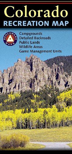
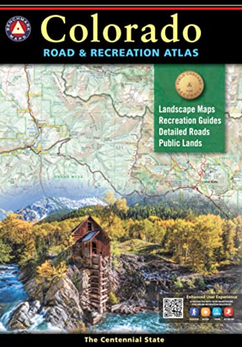
Paperback. Condition: New. Benchmark's Colorado Road and Recreation Atlas is designed to help residents and visitors make the most of Colorado's endless recreation opportunities. The recreation guide includes lists of attractions, trailheads, fishing spots, historic sites, and much more throughout the state. The Landscape Maps s…how all drivable roads, classed by surface and purpose. Large-scale metro maps of Denver, Boulder, and Colorado Springs are also included.

- Softcover
Seller: Rarewaves.com USA, London, LONDO, United KingdomRarewaves.com USA
Contact seller5-star sellerCondition: New
US$ 37.50
Free ShippingShips from United Kingdom to U.S.A.Quantity: 13 available
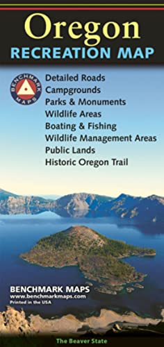
Paperback. Condition: New. Oregonians love their state, Benchmark's home state, and they love this atlas. They rave about how clearly it maps the roads and how easy it is to find landmarks. The recreation guide includes regional public land ownership maps with lists of attractions, trailheads, fishing spots, historic sites, and…much more. The Landscape Maps show all drivable roads, classed by surface and purpose, as they move through varied terrain throughout Oregon and along its Pacific coast.
- Map
Seller: Sunshine State Books, Lithia, FL, U.S.A.Sunshine State Books
Contact seller4-star sellerCondition: Used - Very good
US$ 23.35
US$ 6.53 shippingShips within U.S.A.Quantity: 1 available
map. Condition: Very Good. Paperback--excellent condition.
- Softcover
Seller: Grand Eagle Retail, Bensenville, IL, U.S.A.Grand Eagle Retail
Contact seller5-star sellerCondition: New
US$ 39.75
Free ShippingShips within U.S.A.Quantity: 1 available
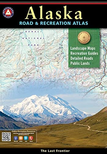
Paperback. Condition: new. Paperback. Alaska truly is the Last Frontier. No other publication can display this rugged scenery and recreation potential with more precision than Benchmark's Alaska Road & Recreation Atlas. The Landscape Maps reveal landforms with amazing realism and detail, clearly showing how the state's vast netw…ork of roads, waterways, and recreation landmarks fit into the landscape. A complete Recreation Guide lists a myriad of outdoor activities. Arranged by category and boasting unequalled insight and detail, it is the ideal planning tool from a simple scouting trip to an extended exploration. Benchmark field-checkers drove several thousand miles to make sure the Alaska Road & Recreation Atlas is the most accurate, comprehensive, and reliable map product ever published for the 49th State. Alaska truly is the Last Frontier. No other publication can display this rugged scenery and recreation potential with more precision than Benchmarks Alaska Road & Recreation Atlas. Shipping may be from multiple locations in the US or from the UK, depending on stock availability. Benchmark Maps (illustrator).

Seller: Blue Vase Books, Interlochen, MI, U.S.A.Blue Vase Books
Contact seller5-star sellerCondition: Used - Good
US$ 31.29
Free ShippingShips within U.S.A.Quantity: 1 available
Condition: good. The item shows wear from consistent use, but it remains in good condition and works perfectly. All pages and cover are intact including the dust cover, if applicable . Spine may show signs of wear. Pages may include limited notes and highlighting. May NOT include discs, access code or other supplemental material…s.
Seller: PBShop.store US, Wood Dale, IL, U.S.A.PBShop.store US
Contact seller5-star sellerCondition: New
US$ 31.60
Free ShippingShips within U.S.A.Quantity: 10 available
PAP. Condition: New. New Book. Shipped from UK. Established seller since 2000.
- Softcover
Seller: Revaluation Books, Exeter, United KingdomRevaluation Books
Contact seller5-star sellerCondition: New
US$ 29.57
US$ 13.39 shippingShips from United Kingdom to U.S.A.Quantity: 1 available
Paperback. Condition: Brand New. map edition. 95 pages. 15.00x10.25x0.50 inches. In Stock. Benchmark Maps (illustrator).
- Softcover
Seller: medimops, Berlin, Germanymedimops
Contact seller5-star sellerCondition: Used - Very good
US$ 33.72
US$ 11.44 shippingShips from Germany to U.S.A.Quantity: 1 available
Condition: very good. Gut/Very good: Buch bzw. Schutzumschlag mit wenigen Gebrauchsspuren an Einband, Schutzumschlag oder Seiten. / Describes a book or dust jacket that does show some signs of wear on either the binding, dust jacket or pages. Benchmark Maps (illustrator).
Seller: PBShop.store US, Wood Dale, IL, U.S.A.PBShop.store US
Contact seller5-star sellerCondition: New
US$ 33.92
Free ShippingShips within U.S.A.Quantity: 15 available
PAP. Condition: New. New Book. Shipped from UK. Established seller since 2000.
Seller: PBShop.store UK, Fairford, GLOS, United KingdomPBShop.store UK
Contact seller5-star sellerCondition: New
US$ 31.70
US$ 5.57 shippingShips from United Kingdom to U.S.A.Quantity: 10 available
PAP. Condition: New. New Book. Shipped from UK. Established seller since 2000.
- Softcover
Seller: Revaluation Books, Exeter, United KingdomRevaluation Books
Contact seller5-star sellerCondition: New
US$ 32.03
US$ 16.74 shippingShips from United Kingdom to U.S.A.Quantity: 1 available
Paperback. Condition: Brand New. 2016 edition. 144 pages. 15.50x10.80x0.50 inches. In Stock. Benchmark Maps (illustrator).

- Softcover
Seller: Rarewaves.com USA, London, LONDO, United KingdomRarewaves.com USA
Contact seller5-star sellerCondition: New
US$ 50.38
Free ShippingShips from United Kingdom to U.S.A.Quantity: 1 available
Paperback. Condition: New. 2014th Revised ed. Yellowstone is our first national park and combined with Grand Teton National Park, the region is unrivaled in geologic wonder, dramatic landscapes, and unique wildlife. Benchmark Maps partnered with the University of Oregon's Department of Geography's InfoGraphics Lab to develop a n…ew recreation atlas that complements their successful academic title Atlas of Yellowstone. The result was this specialty recreation atlas and guide for Greater Yellowstone and Grand Teton. We hope you enjoy the features of this atlas of these national parks, the cornerstones of western park lands.

- Softcover
Seller: Rarewaves.com USA, London, LONDO, United KingdomRarewaves.com USA
Contact seller5-star sellerCondition: New
US$ 57.59
Free ShippingShips from United Kingdom to U.S.A.Quantity: 1 available
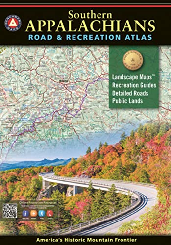
Paperback. Condition: New. 2020 ed. The result of over two years of field-checking and cartographic work, this large format 144-page book illustrates the diverse terrain and public lands of the Southern Appalachians from Harpers Ferry in the northeast to Springer Mountain and the Little River Canyon in the southwest. The Benchma…rk Maps team has been field-checking and mapping the American West since 1995. Our Road and Recreation Atlases for 13 western states showcase the varied landscapes and vast public lands from the Pacific Coast to the Rocky Mountains, from Texas and the deserts of the Southwest to the tundra and fjords of Alaska. In 2018, we turned our attention eastward and began work on the Southern Appalachians Road and Recreation Atlas. Departing from the usual margins defined by state boundaries, we combined portions of ten states to establish the project's scope. Thousands of miles were then driven through the region, visiting national and state parks, noting various points of interest, and interviewing local public land management agencies. From front to back, this new atlas brings a fresh and comprehensive view of the Southern Appalachians and the extensive recreation opportunities found in and around the mountains. Recreation Guide (36 pages) Public Land Maps and Categorized Recreation Listings Blue Ridge Parkway with elevation profiles and attractions by mile marker Great Smoky Mountain National Park Shenandoah National Park Climate Graphs with Monthly Temp and Precip. Averages Information Resources with Contact Details POI Categories include Nat?l and State Parks, Forests and Wildlife Areas, Boating and Fishing Access, Natural Wonders and Trails, OHV Areas, Historic Sites and Museums, Other Attractions, Campgrounds, RV Parks, and more? Landscape Maps (88 pages) Land Cover with Public Land Boundaries Point Elevations on Towns, Lakes, Peaks, etc. Multiple road classifications including: Interstates, Toll roads, Divided highways, Paved roads, Unpaved roads, and Four-wheel-drive roads Attractions and Recreation Access Map Scales: Landscape Maps 1:190,080 or 1' = 3 miles Recreation Maps 1: 760,320 or 1' = 12 miles Blue Ridge Parkway 1:360,000 or 1' = 5.7 miles Great Smoky Mountains NP 1:253,440 or 1' = 4 miles Shenandoah NP 1:348,480 or 1' = 5.5 miles.
- Softcover
Seller: Revaluation Books, Exeter, United KingdomRevaluation Books
Contact seller5-star sellerCondition: New
US$ 49.87
US$ 13.39 shippingShips from United Kingdom to U.S.A.Quantity: 1 available
Paperback. Condition: Brand New. map edition. 95 pages. 15.00x10.25x0.50 inches. In Stock. Benchmark Maps (illustrator).
- Softcover
Seller: Revaluation Books, Exeter, United KingdomRevaluation Books
Contact seller5-star sellerCondition: New
US$ 52.42
US$ 16.74 shippingShips from United Kingdom to U.S.A.Quantity: 1 available
Paperback. Condition: Brand New. map edition. 126 pages. 15.00x10.50x0.50 inches. In Stock. Benchmark Maps (illustrator).

- Softcover
Seller: moluna, Greven, Germanymoluna
Contact seller5-star sellerCondition: New
US$ 38.96
US$ 56.05 shippingShips from Germany to U.S.A.Quantity: Over 20 available
Condition: New.

- Softcover
Seller: AussieBookSeller, Truganina, VIC, AustraliaAussieBookSeller
Contact seller5-star sellerCondition: New
US$ 60.15
US$ 37.00 shippingShips from Australia to U.S.A.Quantity: 1 available
Paperback. Condition: new. Paperback. Alaska truly is the Last Frontier. No other publication can display this rugged scenery and recreation potential with more precision than Benchmark's Alaska Road & Recreation Atlas. The Landscape Maps reveal landforms with amazing realism and detail, clearly showing how the state's vast netw…ork of roads, waterways, and recreation landmarks fit into the landscape. A complete Recreation Guide lists a myriad of outdoor activities. Arranged by category and boasting unequalled insight and detail, it is the ideal planning tool from a simple scouting trip to an extended exploration. Benchmark field-checkers drove several thousand miles to make sure the Alaska Road & Recreation Atlas is the most accurate, comprehensive, and reliable map product ever published for the 49th State. Alaska truly is the Last Frontier. No other publication can display this rugged scenery and recreation potential with more precision than Benchmarks Alaska Road & Recreation Atlas. Shipping may be from our Sydney, NSW warehouse or from our UK or US warehouse, depending on stock availability. Benchmark Maps (illustrator).

- Softcover
Seller: AHA-BUCH GmbH, Einbeck, GermanyAHA-BUCH GmbH
Contact seller5-star sellerCondition: New
US$ 37.38
US$ 69.89 shippingShips from Germany to U.S.A.Quantity: 1 available
Taschenbuch. Condition: Neu. Neuware - Yellowstone is our first national park and combined with Grand Teton National Park, the region is unrivaled in geologic wonder, dramatic landscapes, and unique wildlife. Benchmark Maps partnered with the University of Oregon's Department of Geography's InfoGraphics Lab to develop a new recr…eation atlas that complements their successful academic title Atlas of Yellowstone. The result was this specialty recreation atlas and guide for Greater Yellowstone and Grand Teton. We hope you enjoy the features of this atlas of these national parks, the cornerstones of western park lands.

- Softcover
Seller: Rarewaves.com UK, London, United KingdomRarewaves.com UK
Contact seller5-star sellerCondition: New
US$ 35.48
US$ 87.06 shippingShips from United Kingdom to U.S.A.Quantity: 13 available
Paperback. Condition: New. Oregonians love their state, Benchmark's home state, and they love this atlas. They rave about how clearly it maps the roads and how easy it is to find landmarks. The recreation guide includes regional public land ownership maps with lists of attractions, trailheads, fishing spots, historic sites, and…much more. The Landscape Maps show all drivable roads, classed by surface and purpose, as they move through varied terrain throughout Oregon and along its Pacific coast.

- Softcover
Seller: Rarewaves.com UK, London, United KingdomRarewaves.com UK
Contact seller5-star sellerCondition: New
US$ 40.66
US$ 87.06 shippingShips from United Kingdom to U.S.A.Quantity: 8 available
Paperback. Condition: New. Benchmark's Colorado Road and Recreation Atlas is designed to help residents and visitors make the most of Colorado's endless recreation opportunities. The recreation guide includes lists of attractions, trailheads, fishing spots, historic sites, and much more throughout the state. The Landscape Maps s…how all drivable roads, classed by surface and purpose. Large-scale metro maps of Denver, Boulder, and Colorado Springs are also included.


