Bouclet (14 results)

- Softcover
Seller: medimops, Berlin, , Germanymedimops
Contact seller5-star sellerCondition: Used - Very good
US$ 15.50
US$ 11.54 shippingShips from Germany to U.S.A.Quantity: 1 available
Condition: very good. Gut/Very good: Buch bzw. Schutzumschlag mit wenigen Gebrauchsspuren an Einband, Schutzumschlag oder Seiten. / Describes a book or dust jacket that does show some signs of wear on either the binding, dust jacket or pages.

Published by Editions Libro-Sciences SPRI 1973
- Hardcover
Seller: L'Art du Livre, Arnay-le-Duc, , FranceL'Art du Livre
Contact seller5-star sellerCondition: Used - Near fine
US$ 24.36
US$ 10.38 shippingShips from France to U.S.A.Quantity: 1 available
Couverture rigide. Condition: Bon. Pour les envois à l'étranger, il est préférable de me consulter sur les frais de port avant d'acheter. En effet le tarif "livres et brochures", très économique, est supprimé depuis le 1er juillet 2025. Le montant des frais de port pour les envois à l'étranger est désormais beaucoup plus élevé.…Par ailleurs les envois de marchandises aux Etats-Unis sont suspendus jusqu'à nouvel ordre par la poste française. Il est donc inutile actuellement de passer commande depuis ce pays.
 More images
Language: French
Published by Libro-Sciences, Bruxelles 1973
- Hardcover
Seller: Librairie RAIMOND, Dourges, , FranceLibrairie RAIMOND
Contact seller5-star sellerCondition: Used - Fine
US$ 23.76
US$ 23.07 shippingShips from France to U.S.A.Quantity: 1 available
Couverture rigide. Condition: Très bon. Marcel BOUCHER-Maurice BOUCLET-Jean Marie LORAIN-Jacques PENOT BLOIS A LA BELLE EPOQUE Préface du docteur Jean Mornet 1973, Bruxelles, Edition Libro-Sciences Format : In-12 oblong (21 x 15 cm), relié, non paginé Reliure cartonnage éditeur toilé bleu illustré de 153 reproductions de cartes…postales anciennes Contenu du livre : Promenade en ville, les marchés, petits métiers, industries blésoises, sports, transports, l'actualité avant 1914, les fêtes, la fin de la Belle Epoque Etat : excellent état, proche du neuf poids : 550g.

- Softcover
Seller: Joie de Livre, Varennes sur Amance, , FranceJoie de Livre
Contact seller5-star sellerCondition: Used - Very good
US$ 16.05
US$ 31.72 shippingShips from France to U.S.A.Quantity: 1 available
Soft cover. Condition: Very Good. Français, couverture souple, grand format, très bon état, 96 pages.
 More images
Published by Imprimerie du Viguier Toulouse 1950
- Softcover
Seller: Librairie L'Aubaine, MONTOLIEU, , FranceLibrairie L'Aubaine
Contact seller5-star sellerCondition: Used - Good
US$ 42.77
US$ 10.38 shippingShips from France to U.S.A.Quantity: 1 available
Couverture souple. Condition: Satisfaisant. une plaquette agrafée de 60 pages ( 16 cm X 24 cm ) des pliures à la couverture sinon bon état table des matières en photo.

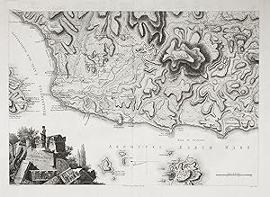
"Plan de Maito et de Kilia" - Eceabat Maydos Canakkale province Marmara region Turkey Türkei map Karte Plan
Choiseul-Gouffier, Marie-Gabriel-Florent-Auguste de, Bouclet und M. Dubois:
Language: French
Published by Paris 1782-1822. 1782
- First Edition
- Map
Seller: Antiquariat Steffen Völkel GmbH, Seubersdorf, GermanyAntiquariat Steffen Völkel GmbH
Contact seller5-star sellerCondition: Used
US$ 17.81
US$ 34.61 shippingShips from Germany to U.S.A.Quantity: 1 available
OriginalKupferstich von 1782-1822 aus der Erstausgabe "Voyage Pittoresque de la Grece" von Marie-Gabriel-Florent-Auguste de Choiseul-Gouffier. -- Blattmasse: ca. 11 x 19,5 cm. -- gut erhalten. || Original copper engraving from 1782-1822 out of Marie-Gabriel-Florent-Auguste de Choiseul-Gouffier's "Voyage Pittoresque de la Grece".… in good condition. // Wir, das Antiquariat Steffen Völkel, kaufen und verkaufen alte Bücher, Handschriften, Zeichnungen, Autographen, Grafiken und Fotografien. Wir sind stets am Ankauf von kompletten Bibliotheken, Sammlungen und Nachlässen interessiert. Sprache: Französisch Gewicht in Gramm: 10.

"Plan de Maito et de Kilia" - Eceabat Maydos Canakkale province Marmara region Turkey Türkei map Karte Plan
Choiseul-Gouffier, Marie-Gabriel-Florent-Auguste de, Bouclet und M. Dubois:
Language: French
Published by Paris 1782-1822. 1782
- First Edition
- Map
Seller: Antiquariat Steffen Völkel GmbH, Seubersdorf, GermanyAntiquariat Steffen Völkel GmbH
Contact seller5-star sellerCondition: Used
US$ 17.81
US$ 34.61 shippingShips from Germany to U.S.A.Quantity: 1 available
OriginalKupferstich von 1782-1822 aus der Erstausgabe "Voyage Pittoresque de la Grece" von Marie-Gabriel-Florent-Auguste de Choiseul-Gouffier. -- Blattmasse: ca. 13 x 26 cm. -- gut erhalten. || Original copper engraving from 1782-1822 out of Marie-Gabriel-Florent-Auguste de Choiseul-Gouffier's "Voyage Pittoresque de la Grece". i…n good condition. || // Wir, das Antiquariat Steffen Völkel, kaufen und verkaufen alte Bücher, Handschriften, Zeichnungen, Autographen, Grafiken und Fotografien. Wir sind stets am Ankauf von kompletten Bibliotheken, Sammlungen und Nachlässen interessiert. Sprache: Französisch Gewicht in Gramm: 10.

- Softcover
Seller: RECYCLIVRE, Paris, , FranceRECYCLIVRE
Contact seller5-star sellerCondition: Used - Fine
US$ 23.68
US$ 74.98 shippingShips from France to U.S.A.Quantity: 1 available
Condition: Très bon. Merci, votre achat aide à financer des programmes de lutte contre l'illettrisme.

- Hardcover
Seller: ECOSPHERE, Champs sur marne, , FranceECOSPHERE
Contact seller5-star sellerCondition: New
US$ 53.47
US$ 74.98 shippingShips from France to U.S.A.Quantity: 1 available
Couverture rigide. Condition: Neuf.
"Carte de la Plaine de Troie levée en 1786 et 1787" - Troy Troja Hisarlik Canakkale Turkey Türkei map Karte Bozcaada Tenedos island
Choiseul-Gouffier, Marie-Gabriel-Florent-Auguste de, J. D. Barbie du Bocage und Bouclet:
Language: French
Published by Paris 1782-1822. 1782
- First Edition
- Map
Seller: Antiquariat Steffen Völkel GmbH, Seubersdorf, GermanyAntiquariat Steffen Völkel GmbH
Contact seller5-star sellerCondition: Used
US$ 71.28
US$ 34.61 shippingShips from Germany to U.S.A.Quantity: 1 available
OriginalKupferstich-Karte von 1782-1822 aus der Erstausgabe "Voyage Pittoresque de la Grece" von Marie-Gabriel-Florent-Auguste de Choiseul-Gouffier. -- Blattmasse: ca. 53 x 67 cm. -- gut erhalten. || Original engraved map from 1782-1822 out of Marie-Gabriel-Florent-Auguste de Choiseul-Gouffier's "Voyage Pittoresque de la Grece".… in good condition. // Wir, das Antiquariat Steffen Völkel, kaufen und verkaufen alte Bücher, Handschriften, Zeichnungen, Autographen, Grafiken und Fotografien. Wir sind stets am Ankauf von kompletten Bibliotheken, Sammlungen und Nachlässen interessiert. Sprache: Französisch Gewicht in Gramm: 15.

"Carte de la Plaine de Troie levée en 1786 et 1787" - Troy Troja Hisarlik Canakkale Turkey Türkei map Karte Bozcaada Tenedos island
Choiseul-Gouffier, Marie-Gabriel-Florent-Auguste de, J. D. Barbie du Bocage und Bouclet:
Language: French
Published by Paris 1819
- First Edition
- Map
Seller: Antiquariat Steffen Völkel GmbH, Seubersdorf, GermanyAntiquariat Steffen Völkel GmbH
Contact seller5-star sellerCondition: Used
US$ 83.17
US$ 34.61 shippingShips from Germany to U.S.A.Quantity: 1 available
OriginalKupferstich-Karte von 1782-1822 aus der Erstausgabe "Voyage Pittoresque de la Grece" von Marie-Gabriel-Florent-Auguste de Choiseul-Gouffier. -- Bild-Maße: ca. 40,5 x 57 cm. -- gut erhalten. || Original engraved map from 1782-1822 out of Marie-Gabriel-Florent-Auguste de Choiseul-Gouffier's "Voyage Pittoresque de la Grece"…. in good condition. // Wir, das Antiquariat Steffen Völkel, kaufen und verkaufen alte Bücher, Handschriften, Zeichnungen, Autographen, Grafiken und Fotografien. Wir sind stets am Ankauf von kompletten Bibliotheken, Sammlungen und Nachlässen interessiert. Sprache: Französisch Gewicht in Gramm: 15.
 More images
Published by Imprimerie de la République, (Paris) 1797
- First Edition
Seller: Long Brothers Fine & Rare Books, ABAA, Seattle, WA, U.S.A.Long Brothers Fine & Rare Books, ABAA
Contact seller3-star sellerCondition: Used - Very good
US$ 250.00
US$ 3.50 shippingShips within U.S.A.Quantity: 1 available
Folio Leaf. Condition: Very Good+. First Edition. Elephant Folio. Leaf measures 33.25" x 23.25" while the printed chart is 26.5" x 19.5". Fold at center, as issued. Condition is Very Good+ with very light foxing within the plate and slightly darker foxing in the top right margin. A dampstain the size of a fifty-cent piece at the… lower right corner, outside the border rule and not affecting print impression. La Pérouse was France's answer to Captain James Cook. Directed by King Louis XVI to explore and chart the Pacific, in 1785 La Pérouse set sail from France with the frigates Boussole and Astrolabe . and never returned. After years of speculation and expeditions sent in search of the ships, their 1788 shipwrecked-fate, in the South Seas, was finally ascertained. Prior to disappearing, La Pérouse dispatched a courier homeward, overland via Russia, with his narrative, charts, and artist-depictions, to-date. His achievements were published in 1797, including this chart.This chart, covering the coastline from Cape Rond (Tillamook Head) northward to the Baie de Clonard (present-day Queen Charlotte Islands, or Haida Gwaii), was the only chart of the region other than works by or based on Cook's efforts. Three Spanish voyages, and Cook's third voyage, had visited the west coast of now-known Vancouver Island before La Pérouse. As depicted in this chart, the land mass is not yet known by the place-name "Vancouver," nor is it recognized as an island. LADA-MOCARSKI (52) claims the best charting by La Pérouse is on the Asian side of the Pacific. Indeed, it must be noted that La Pérouse, like Cook, missed both the Columbia River and the Strait of Juan de Fuca. See WAGNER, Cartography of the Northwest Coast of America, 840. Hérault / Bouclet (illustrator).

Published by Artist: Bouclet ca : 1710
Seller: Antique Sommer& Sapunaru KG, München, , GermanyAntique Sommer& Sapunaru KG
Contact seller4-star sellerCondition: Used
US$ 368.32
US$ 51.91 shippingShips from Germany to U.S.A.Quantity: 1 available
Technic: Copper print, colorit: original colored, condition: Very good, size (in cm): 21,5 x 32,5, Map shows the passage of Gibraltar with Gibraltar and Ceuta.

Published by c.1793, Paris 1793
- Art Print
Seller: Frame, Madrid, M, SpainFrame
Contact seller5-star sellerCondition: Used - Good
US$ 564.36
US$ 57.68 shippingShips from Spain to U.S.A.Quantity: 1 available
Condition: ACEPTABLE. [Un] Mapahistórico, titulado "Plan De La Baye De Vigo", que detalla el asalto naval de 1702 realizado por las flotas de Inglaterra y Holanda contra los galiones españoles en la ensenada de San Simón. Destaca la geografía de la ría, desde las Islas de Bayona (hoy Islas Cíes) hasta el Puerto de Redondela, mos…trando la disposición táctica de los navíos y las líneas de ataque sobre la estacada defensiva. En el cuadrante inferior derecho, una leyenda titulada "Mouvements Des Alliés" explica los puntos clave de la expedición, incluyendo las zonas de anclaje, el desembarco de tropas para atacar las baterías españolas y el avance de los barcos para romper las defensas. Título completo: "Plan de la Baye de Vigo et d l' Attaque Des Galions d' Espagne, Par La Flote Combinée d' Angleterre et de Hollande En 1702.". ["Bouclet sculpsit. ; L. Aubert scripsit."] . Formato (cm): 21x33.


