Brue Adrien (89 results)
- Softcover
Seller: moluna, Greven, Germanymoluna
Contact seller5-star sellerCondition: New
US$ 25.60
US$ 55.75 shippingShips from Germany to U.S.A.Quantity: Over 20 available
Condition: New.

Language: French
Published by E. Andriveau-Goujon, Paris 1863
- Hardcover
Seller: Samuel Lasenby Bookseller, Corona del Mar, CA, U.S.A.Samuel Lasenby Bookseller
Contact seller4-star sellerCondition: Used - Very good
US$ 85.00
US$ 5.00 shippingShips within U.S.A.Quantity: 1 available
Cloth. Condition: Very Good. First Thus. Green boards with tooled design. Gilt title on front and spine. Nouvelle Edition Part of Atlas Universal series. Folding Map Image folds out to 26" x 39" [66 x 99 centimeters] Map very good condtion with some color high lights. 1 3/4" tear spine edge and also 1/2" and 3/4" section. Publis…her gilt title on rear board.

- Softcover
Seller: AHA-BUCH GmbH, Einbeck, GermanyAHA-BUCH GmbH
Contact seller5-star sellerCondition: New
US$ 30.13
US$ 68.54 shippingShips from Germany to U.S.A.Quantity: 2 available
Taschenbuch. Condition: Neu. Neuware - This work has been selected by scholars as being culturally important, and is part of the knowledge base of civilization as we know it. This work was reproduced from the original artifact, and remains as true to the original work as possible. Therefore, you will see the original copyright r…eferences, library stamps (as most of these works have been housed in our most important libraries around the world), and other notations in the work.
 More images
Published by Paris 1827
- Softcover
- Map
Seller: Bolivar Old Prints Anticuario, Barcelona, B, SpainBolivar Old Prints Anticuario
Contact seller5-star sellerCondition: Used - Very good
US$ 64.47
US$ 28.45 shippingShips from Spain to U.S.A.Quantity: 1 available
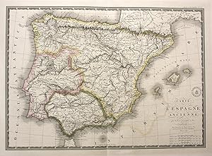
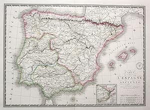
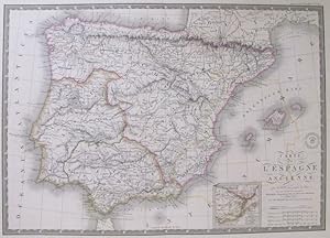
Sin Encuadernar - No binding. Condition: Bueno. 37x51. 37 x 51 cm. Mapa detalladamente coloreado de la antigua España, que incluye las Islas Baleares, realizado por Adrien Hubert Brué y fechado en 1827 [revisado en 1829]. Este mapa proporciona una visión detallada de la península Ibérica durante la dominación romana, mostrando l…as principales divisiones territoriales de Tarraconensis, Lusitania y Bética delineadas en colores distintivos. Los hachures destacan las características del relieve. Todas las escalas y leyendas se encuentran en la parte inferior derecha del mapa. ----------------------------- A hand-coloured map of Ancient Spain, including the Balearic islands, made by Adrien Hubert Brué, dated 1827 [revised in 1829]. The map sheds light on the Iberian peninsula during Rome's rule, with the main territorial subdivisions of Tarraconensis, Lusitania and Betica outlined in colour. Hachures show relief features. All scales and legends are displayed at the bottom, on the right-hand side of the map. Idioma: Francés. Good (bueno).
 More images
Language: French
Published by Goujon, Paris 1818
- Hardcover
Seller: Auceps-Antiquariat Sebastian Vogler, Weimar, GermanyAuceps-Antiquariat Sebastian Vogler
Contact seller5-star sellerCondition: Used - Near fine
US$ 257.87
US$ 76.81 shippingShips from Germany to U.S.A.Quantity: 1 available
Hardcover. Condition: Sehr gut. 1 Kt. auf 4 Einzelbl., Kupferst., Gesamtgr. 154 x 108 cm, je Bl. 77 x 54 cm, Mit Tabelle auf d. rechten Kartenrand. Maßstab in graph. Form (Mètres ; toises ; Milles de 15 au Degré), farbige Grenzlinien. Auf Leinen aufgezogen, mehrfach gefaltet in grünem Schuber mit Rückentitel- u. altem Signaturen…schildchen.
Language: English
Published by Desrai, Goujon, Paris 1814
- Map
Seller: Anah Dunsheath RareBooks ABA ANZAAB ILAB, Auckland, NZ, New ZealandAnah Dunsheath RareBooks ABA ANZAAB ILAB
Contact seller5-star sellerCondition: Used - Very good
US$ 526.50
US$ 25.00 shippingShips from New Zealand to U.S.A.Quantity: 1 available
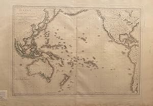
No Binding. Condition: Very Good. Large hand-coloured map of South-east Asia, the China coast, Japan, the west coast of North and South America, Australia, New Zealand and the Pacific. The map has a dedication to the Comte d'Artois. New Zealand is labelled 'Fabieno-Mauwe' (North Isl.) and Tauai-Poenammoo' (South Isl.). One of a…series by the famed cartographer Adrien-Herbert Brue, published in the same year as Flinder's publication of his circumnavigation of Australia. 60 x 100 cm A fine very detailed map.
 More images
Language: French
Published by Chez l'Auteur 1821
- Softcover
- Map
Seller: Librairie du Cardinal, GRADIGNAN, FranceLibrairie du Cardinal
Contact seller5-star sellerCondition: Used - Near fine
US$ 2,285.65
US$ 28.45 shippingShips from France to U.S.A.Quantity: 1 available
souple. Condition: Bon. Par A. H. Brué, Géographe de S.A.R. Monsieur, Dédiée à Monsieur le Baron Cuvier, Conseiller d'Etat ordinaire, l'Un des Quarante de l'Académie Française, Secretaire Perpétuel de celle des Sciences, &c, &c., 1 carte dépliante entoilée format 102,5 x 186 cm, Chez l'Auteur, à Paris, Juin 1820, augmentée en nb…re 1821, avec le cachet à froid de l'auteur portant la mention "carte encyprotipe" (gravée sur cuivre) : "Depuis 1822, l'auteur ne donne ses soins qu'aux cartes qui portent son adresse et ce timbre. Il est étranger, depuis cette époque, à tout travail ou changement des autres cartes". Belle mappemonde de grand format (quelques marges élimées et qq. petites fentes en pliure, papier lég. bruni, bel état par ailleurs). Langue: Français.
Language: German
Published by Paris 1827
- Map
Seller: Antiquariat Steffen Völkel GmbH, Seubersdorf, GermanyAntiquariat Steffen Völkel GmbH
Contact seller5-star sellerCondition: Used
US$ 35.15
US$ 34.14 shippingShips from Germany to U.S.A.Quantity: 1 available
original kolorierte Kupferstich-Karte von 1827 - Blatt-Format: ca. 68,5 x 53,5 cm - Plattenmasse: ca. 55,5 x 40,5 cm - teils leicht fleckig, mit Randeinrissen im Außenrand, sonst gut erhalten. | original colored copper engraved map from 1827 - partly slightly stained, with marginal tears in outer margins, otherwise in good condi…tion. | Original! - Kein Nachdruck! - Keine Kopie! | This is an original! - No reprint! - No copy! // Wir, das Antiquariat Steffen Völkel, kaufen und verkaufen alte Bücher, Handschriften, Zeichnungen, Autographen, Grafiken und Fotografien. Wir sind stets am Ankauf von kompletten Bibliotheken, Sammlungen und Nachlässen interessiert. Sprache: Deutsch Gewicht in Gramm: 1500.
Language: German
Published by Paris 1830
- Map
Seller: Antiquariat Steffen Völkel GmbH, Seubersdorf, GermanyAntiquariat Steffen Völkel GmbH
Contact seller5-star sellerCondition: Used
US$ 35.15
US$ 34.14 shippingShips from Germany to U.S.A.Quantity: 1 available
original kolorierte Kupferstich-Karte von ca. 1830 - Blatt-Format: ca. 66 x 52,5 cm - Plattenmasse: ca. 54,5 x 39,5 cm - teils leicht fleckig, mit Randeinrissen im Außenrand, sonst gut erhalten. | original colored copper engraved map from about 1830 - partly slightly stained, with marginal tears in outer margins, otherwise in go…od condition. | Original! - Kein Nachdruck! - Keine Kopie! | This is an original! - No reprint! - No copy! // Wir, das Antiquariat Steffen Völkel, kaufen und verkaufen alte Bücher, Handschriften, Zeichnungen, Autographen, Grafiken und Fotografien. Wir sind stets am Ankauf von kompletten Bibliotheken, Sammlungen und Nachlässen interessiert. Sprache: Deutsch Gewicht in Gramm: 1500.
 More images
Published by Paris 1821
- Softcover
- Map
Seller: Bolivar Old Prints Anticuario, Barcelona, B, SpainBolivar Old Prints Anticuario
Contact seller5-star sellerCondition: Used - Very good
US$ 152.38
US$ 28.45 shippingShips from Spain to U.S.A.Quantity: 1 available
Sin Encuadernar - No binding. Condition: Bueno. 41,5 x 56,5. 41 x 56 cm. Mapa coloreado a mano de España y Portugal, incluidas las islas Baleares, creado por Adrien Hubert Brué en 1821. El mapa se centra en la península ibérica, con las principales regiones o subdivisiones territoriales delineadas en color. Todas las escalas y l…eyendas se muestran en la parte inferior derecha del mapa. ------------------------------------------------- A hand-coloured map of Spain and Portugal, including the Balearic islands, created by Adrien Hubert Brué, dated 1821. The map focuses on the Iberian peninsula, with the main regions or territorial subdivisions delineated in colour. All scales and legends are displayed at the bottom, on the right-hand side of the map. Idioma: Francés. Good (bueno).
 More images
Published by A. Brue, Paris, France 1828
Seller: Aardvark Rare Books, EUGENE, OR, U.S.A.Aardvark Rare Books
Contact seller5-star sellerCondition: Used - Very good
US$ 94.00
Free ShippingShips within U.S.A.Quantity: 1 available
Map. Condition: Very Good Plus. Copper engraved handcolored map of The British Isles. Map: 20 in. x 14 in., Paper: 26.2 in. x 21 in. Relief shown by hatures. Prime meridian based on Paris. Title and legend at top upper right; five scales at bottom left. Inset map of Shetland Islands at top left. Center horizontal fold, as origin…ally presented. Light age-toning to paper. Adrien-Hubert Brué (1786-1832) was a preeminent French cartographer and geographer to the King, renowned for the high accuracy and detail of his maps between 1810 and 1830. Known for "enprototype" maps (drawn directly onto copper), recognized for remarkable clarity, purity of engraving, and high topicality.

Published by Paris 1827
- Softcover
- Map
Seller: Bolivar Old Prints Anticuario, Barcelona, B, SpainBolivar Old Prints Anticuario
Contact seller5-star sellerCondition: Used - Very good
US$ 257.87
US$ 28.45 shippingShips from Spain to U.S.A.Quantity: 1 available
Sin Encuadernar. Condition: Bueno. Detallado mapa original de Polonia y el occidente de Rusia. Abarca desde Suecia y Finlandia hasta Hungría y el Mar Negro. Este mapa antiguo fue creado para el Atlas Universel de Geographie physique, politique, ancienne et moderne, publicado por Adrien Hubert Brué en París cuya primera edición f…ue de 1822 y se reeditó hasta 1846 por su sucesor Charles Picquet, que se hizo cargo de la firma editorial de Brué en 1835. A un costado del título se puede apreciar un sello relativo al derecho de autor del cartógrafo. 51.5 x 36.5 cm. Idioma: Francés. Very good.
Published by Paris 1839
- Softcover
- Art Print
Seller: Frame, Madrid, M, SpainFrame
Contact seller5-star sellerCondition: Used - Good
US$ 246.15
US$ 56.90 shippingShips from Spain to U.S.A.Quantity: 1 available
Condition: ACEPTABLE. Par A. Brué, Géographe du Roi, 1827. Revue, corrigé et augmentée dune Carte particuliére par Ch. Piquet, Géographe du ROI et de Mgr. le Duc dOrléans. [Atlas, en 65 feuilles Nº.10.] Formato (cm): 39x55.
 More images
Published by Chez J Goujon et J Andriveau, Geographes - Editeurs, Rue du Bac No. 6 Pres le Pont Royal, Paris 1827
- Hardcover
- Map
Seller: Crouch Rare Books, Godalming, United KingdomCrouch Rare Books
Contact seller5-star sellerCondition: Used
US$ 323.58
US$ 27.72 shippingShips from United Kingdom to U.S.A.Quantity: 1 available
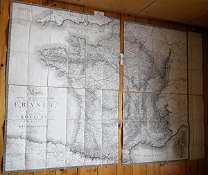
superb, very large, hand coloured, engraved map, linen backed in 32 sections, measuring approximately 1100 x 1540 mm, printed paper title label on verso of map, includes: inset of Corsica and including part of South West England, Spain, Etates Sardes, Grande Duche de Bade, Duche de Luxembourg, Pays-Bas; on right hand side of the… map is a 28 column table extending to the full depth of the map and numerating features such as 'Nos des Division Miliataire. Quartier Generale. Noms, Population et Surface en Hectares des Departemens avec les Distances Legales en Myriametres de Paris, Nombre d'Arrondissemens Communaux etc etc'; comprehensive key to topographical features including 'Canal de Navigation, Canal d'Irrigation au Rigole, Villes Fortifiees, etc etc'; six 'Echelles'; also 'Tableau des Divisions Militaires'; contained in a pressed, cloth covered slip case with decorated guilt borders to front and back and a gilt title on the spine, rubbed on extremities and a couple of marks else very good; map itself with some light offsetting and a few very minor marks as would be expected but otherwise near fine. This is an original antique map. We do not sell reproductions or facsimiles.
 More images
Published by Paris, Brué 1821
- Hardcover
- Art Print
Seller: Inanna Rare Books Ltd., Skibbereen, CORK, IrelandInanna Rare Books Ltd.
Contact seller5-star sellerCondition: Used - As new
US$ 322.34
US$ 31.86 shippingShips from Ireland to U.S.A.Quantity: 1 available
Condition: Wie neu. Original engraving. Plate Size: 50.5 cm x 36.1 cm. Sheet Size: 68 cm x 54.1 cm. Original map. Very good condition. Extra wide margins. Some minor foxing along sheet edges. Discreet author's blind stamp with 'Carte Encyprotipe' and initials 'AB' embossed in top corner of map. Centre-fold as issued. Border with… longitudinal and latitudinal information. Detailed early map of the Caribbean, from an early edition of Brue's Atlas Universel (Pl.35). Rich detail in Florida, the Gulf Coast, Central America. The eye is drawn to Cuba among the islands of the 'Grandes' and 'Petites' Antilles. As demonstrated by the map's political divisions and colourings, Mexico has yet cede control of what will become Texas. Nouva Espagne and Nouv Grenade show that the aged and tottering Spanish empire has still to fall in Central and South America. The division of Hispaniola into its Haitian and Dominican parts is also shown. The great port cities of the infant United States - Charlestown, Savannah and New Orleans - can be seen along the seaboard. Bermuda is shown breaching the map's top border. Reference keys and explanatory annotations and four scale-bars in lower left corner of map. Decorative title in top right corner of map. Adrien-Hubert Brué (1786 - 1832) was a renowned French cartographer. Between 1810 and 1830 Brué established himself as one of the most important French cartographers and it was during this period that his two most important works were published: Grand Atlas Universel in 1815 and Atlas Universel in 1822, which ran to several editions. Atlas Universel was published as a continuation to Grand Atlas Universel. Brué's maps or 'cards' as they were referred to at the time, were characterized by the high degree of accuracy with which they were produced and the meticulous attention to detail employed in their crafting. This was possible due to Brué's application of copper plate intaglio to the process of mapmaking or, as Nouvelles Annales des Voyages et des Sciences Géographiques had it: "by applying to the making of cards this ingenious process of drawing on copper itself". Alexandre von Humboldt, the President of the Société de géographie de Paris praised the accuracy of his work and "clarity that is all the more pleasing to the eye." He also was quick to update his maps with the latest scientific discoveries and nautical measurements. (Wikipedia).

Published by Paris (chez Simonneau) 1830
- Hardcover
- Map
Seller: Libreria Ex Libris ALAI-ILAB/LILA member, Roma, RM, ItalyLibreria Ex Libris ALAI-ILAB/LILA member
Contact seller5-star sellerCondition: Used
US$ 351.64
US$ 34.14 shippingShips from Italy to U.S.A.Quantity: 1 available
Carta geografica originale su 32 riquadri montata su tela a stacchi (cm. 64,7x87,5). Coloritura d'epoca all'acquarello dei confini e della cornice. Entro astuccio in cartone marmorizzato con titolo oro su tassello in pelle al ds. Esemplare in ottimo stato di conservazione. Non comune.

Published by Paris 1843
- Softcover
- Art Print
Seller: Frame, Madrid, M, SpainFrame
Contact seller5-star sellerCondition: Used - Good
US$ 462.99
US$ 56.90 shippingShips from Spain to U.S.A.Quantity: 1 available
Condition: ACEPTABLE. Atlas, en 65 feuilles, Nº 64. [Dressée par A. Brué, Géographe du Roi]. [Argumentée et revue pour les limites par Ch. Picquet, Géographe du Roi et du Duc dOrleans]. Formato (cm): 56x41.
 More images
Published by Paris: Ch. Piquet 1835
- Softcover
- Signed
Seller: Wittenborn Art Books, San Francisco, CA, U.S.A.Wittenborn Art Books
Contact seller4-star sellerCondition: Used - Good
US$ 1,700.00
US$ 10.00 shippingShips within U.S.A.Quantity: 1 available
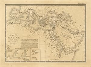
Condition: Good. Folio. 36 x 53.3cm. Contemporary half calf binding with new goatskin spine with original spine overlaid. New endpapers. 65 handcolored doublepage maps.The maps are attached to the binding with hinges .OCLC Number / Unique Identifier:494749885.Barry Ruderman: A tour-de-force of an atlas, issued posthumously under… the name of the prolific mapmaker Adrien-Hubert Brué. This "Nouvelle Édition" of the massive 65-map Atlas Universel, with the maps "revue et augmentée" by Charles Picquet, Geographer to the King, includes excellent maps of the west incorporating some of the latest information available at the time. Brué had issued earlier atlases, going back to the 1816 Grand Atlas Universel, and a versiojn of the Atlas Universel Geographique dated 1822 and another from 1830-1834 (2nd. ed.), before the present much expanded Nouvelle Édition was issued by Picquet.List of the Maps:1. Monde connu des Hébreux.2. Monde connu des Anciens.3. Empire d'Alexandre.4. Empire ancienne, Palestine et Arabie Pétrée.5. Palestine, sous la domination Romaine.6. Gréce ancienne, Archipel, Macédoine, Thrace.7. Asie mineure, Arménie, Syrie, Mésopotamie.8. Italie ancienne, Plan de Rome et de ses environs.9. Les Gaules.10. Espagne ancienne.11. Iles Britanniques et Germanie Anciennes.12. Dacie, Pannonie, Illyrie et Moesie.13. Empire Romain.14. Europe.15. Mappemonde sur la projection de Mercator.16. Mappemonde en Deux Hémisphères.17. Mappemondes.18. Europe en 1789.19. Europe en 1813.20. Europe actuelle.21. Suède, Norvège et Danemark.22. Russie d'Europe.23. Russie occidentale et Royaume de Pologne.24. Îles Britanniques.25. Angleterre et partie méridionale de l'Écosse.26. Belgique, Hollande et Dé. de Luxembourg.27. France en 1789.28. France actuelle. Partie occidentale.29. France actuelle. Partie orientale.30. Suisse (Carte physique et routière de la Confédération.31. Allemagne en 1789.32. Europe Centrale.33. Allemagne occidentale.34. Monarchie Prussienne.35. Empire d'Autriche.36. Espagne et Portugal.37. Italie.38. Italie, Suisse &a. Partie nord.39. Italie, Suisse &a. Partie sud.40. Turquie d'Europe, Grèce et Iles Ioniennes.41. Grèce moderne. Archipel, Albanie, Macédoine, Romélie &a.42. Asie.43. Russie d'Asie.44. Turqui d'Asie, Perse, Arabie, Caboul, Beloutchistan &a.45. Indes, en deça et au dela du Gange.46. Empire Chinois et Japon.47. Océanie, (Cinquieme partie du Monde).48. Archipel d'Asie, ou Iles des Indes Orentales (Partie nord-O, de l'Océanie).49. Australie, (Partie Sud-Ouest de l'Océanie).50. Polynésie, (Parties Orientale et Septentrionale de l'Océanie).51. Afrique, (Carte générale).52. Afrique et Iles qui en dépendent. Partie nord.53. Afrique et Iles qui en dépendent. Parie sud.54. États du nord de l'Afrique, (Barbarie), Égypte et Méditerranée.55. Égypte et Arabie Pétrée.56. Sénégambie, Soudan, et Guinée septentrionale.57. Amérique septentrionale, (Carte Générale).58. États-Unis et Canada.59. États-Unis Mexicains et Provinces-Unies de l'Amérique Centrale.60. Golfe du Mexique et îles Antilles.61. Iles Antilles ou Indes occidentales. 62. Amérique méridionale et îles qui en dépendent.63. Colombie et Guyanes Française, Hollandaise et Anglaise.64. Bás-Pérou, Haut-Pérou ou Bolivia, Chili. États-Unis de Rio de la Plata et Paraguay.65. Brésil et partie des pay adjacents.In-folio, (3) ff. gravés pour le titre, la table et la dédicace, (1) f., 65 feuilles doubles (la grande carte de France comptant pour 2 feuilles), cartes aux limites colorées, elles portent le cachet à sec du géographe daté de 1835. Reliure d'époque demi-veau à coins, dos lisse orné, grande étiquette de titre sur le plat, fentes aux mors, manque de cuir en tête du dos et aux coins, l'état des cartes est impeccable.
 More images
Atlas Universel de Geographie physique politique ancienne and moderne Contenant les cartes generales
Published by Paris, chez Ch. Picquet, géographe du Roie et de S.A.R. 1838
- Hardcover
Seller: Delirium Books · Susana Bardón, Madrid, M, SpainDelirium Books · Susana Bardón
Contact seller5-star sellerCondition: Used - Very good
US$ 1,640.98
US$ 28.45 shippingShips from Spain to U.S.A.Quantity: 1 available
Encuadernación de tapa dura. Condition: Bien. 2ª Edición. Un vol. en folio mayor (53,7 x 23,9 cm.) con su encuadernación original en media piel, tejuelo editorial en papel en plano superior: "Atlas Universel de Geographie ancienne et moderne. Nouvelle édition. 1838". 2 h. inc. port. con orla neoclásica, 65 mapas dobles, con ilum…inación original en los límites. Los mapas de Francia y de Brasil tienen dos zonas desplegables. Título completo en portada: "Atlas Universel de Geographie physique politique ancienne and moderne Contenant les cartes générales et particulières de toutes les parties du Monde. Rédigé conformément aux progrès de la science pour servir à l'intelligence de l'histoire, de la Géographie, et des Voyages. Séconde édition composée de soixante cinq feuilles". Encuadernación rozada en esquinas y cabeza y pie del lomo, algo abierta por el cajo. Etiqueta en guarda superior: CH. Piquet, géographe ordinaire du Roi, et de S.A.S. Msr. le Duc d'Orléans, seul chargé de la vente des Cartes du Dépôt-General de la Guerre, À Paris. Segunda edición, ampliada con respecto a la primera publicada en 1822 y con tan solo 35 mapas. Phillips, 758. Encuadernación rozada en esquinas y cabeza y pie de lomo.
Published by Paris: The Author and Charles Simmonneau, 1822. 1822
- Hardcover
Seller: Arader Galleries - AraderNYC, New York, NY, U.S.A.Arader Galleries - AraderNYC
Contact seller5-star sellerCondition: Used - Very good
US$ 25,000.00
Free ShippingShips within U.S.A.Quantity: 1 available
Hardcover. Condition: Very Good. Folio (21 x 14 4/8 inches). 35 double-page fine engraved maps with contemporary hand-color in outline (except map of France which is coloured in full), each mounted on guards and with vellum finger-tab to the fore-edge (small repair to the map of the United States); EXTRA-ILLUSTRATED with four ad…ditional double-page maps inserted at a later date. Original French green roan, gilt (rebacked and with corners renewed to style). Provenance: 20th-century bookplate on the title-page. The list of maps calls for 36 maps including two French maps, west (No. 18) and east (No. 19), but a larger double-page and in part folding map of all France has been substituted for them by the publisher. The atlas was issued with two significant maps of North America, with the cartographic influences of Lewis and Clark clearly evident - "Carte de l'Amerique Septentrionale" dated Janvier 1820 and "Carte Generale des Etats-Unis de l'Amerique Septentrionale" dated December 1820 (Wheat 336), both showing Ft. Clatsop and Ft. Astoria at the mouth of the Columbia, with what was to be Oregon named "Columbia." In Mexico both maps show the province of San Luis Potosi with no mention of Texas. However, in this unusual copy there are two additional maps by Brue, on same size paper as the original maps, apparently inserted later without vellum tabs - "Carte General des Etats-Unis, du Canada et d'une Partie des Pays Adjacent" dated Paris 1825, and "Carte General des Etats-Unis Mexicains et des Provinces-Unies de l'Amerique Centrale" also dated Paris 1825 (Wheat 361), both showing Oregon and Texas and with much more detail in the California Utah region than the original 1820 maps. In addition, at the end of the atlas, inserted and on slightly smaller trimmed paper without vellum tabs, is the title page from Pierre Lapie's "Atlas Universel de Geographie Ancienne et Moderne" followed by two of Lapie's double page maps - "Carte de l'Amerique Septentrionale" dated Paris 1830 and "Carte des Etats-Unis d'Amerique" dated Paris 1832 (Wheat apparently unaware of this 1832 edition, describes the later 1837 edition in Wheat 428), both showing the District of Columbia and Texas and with no mention of Oregon or San Luis Potosi. Also included is Bure's magnificent map of the Pacific: "Oceanie ou Cinquinne Partie du Monde" (1820). First published in 1814, nearly a decade earlier, Brué had taken part in Nicolas Thomas Baudin's (1754-1803) voyage to Australia, at the young age of 15. Considered one of France's most significant expeditions, vast sections of the Australian coastline were charted and thousands of natural specimens were collected. More importantly, this voyage destroyed Dampier's myth that Australia's West coast was barren. Positive reports from the Baudin Expedition paved the way for subsequent French explorers such as Dumont d'Urville and inspired France to consider Western Australia as a convict colony site. Brué worked as a cartographer and publisher during a key period in the history of mapmaking. By the 19th century, previously accepted geographical myths such as Dampier's had been dispelled, allowing cartographers like Brué and his contemporaries such as Aaron Arrowsmith to depict a more truthful and detailed rendering of the world. Brué went on to become one of the most outstanding European mapmakers of his time, garnering the esteemed title of Geographer de Roi. His work is characterized by accuracy and, at moments, genius. Like all of Brué's maps, "Oceanie ou Cinquinne Partie du Monde" is characterized by elegance and restraint. It was issued separately as a wall map in 1814, rendering it a rare and beautiful example of nineteenth century French cartography. Notable territories and other islands delineated include Australia, New Zealand, South China, the Malay Peninsula, Indonesia, New Guinea and the Coral Sea. Coast contours, island groups and harbor details are finely delineated. Phillips Atlases 758 (later 1834 edition). All maps with a small Brue or La.
Published by L Auteur, Paris 1822
- Hardcover
Seller: Alexandre Antique Prints, Maps & Books, Toronto, ON, CanadaAlexandre Antique Prints, Maps & Books
Contact seller4-star sellerCondition: Used
US$ 1,500.00
US$ 6.00 shippingShips from Canada to U.S.A.Quantity: 1 available
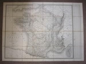
Contemporary full paper, flat spine in six compartments of blind bands, and gilt decorative military motifs, gilt text on two, blank endpapers., Atlas of various maps:1- Tableau de la Dispersion des Peuples Jusqu au Temps de Moise2- Carte Generale du Monde Connu des Anciens3- Carte de L Empire D Alexandre4- Carte Generale de L E…gypte Ancienne5- Carte Generale de la Grece Ancienne Et D Une Partie de Ses Colonies7- Carte General de L Italie Ancienne8- Carte Generale des Gaules9- Carte de L Empire Romais sous Constantin12- Carte de L Europe13- Carte Generale des Royaumes de Suede de Norwege et de Danemark14- Carte Generale de la Russie D Europe en du Royme. De Pologne15- Carte Generale des Illes Britanniques16- Carte du Royaume des Pays - Bas17- Carte Comparatioe de La France en Trente deux Gouvernemens19- Carte de France19.1- Orleans and Environs19.2- Carte des Environs et Fortifications de Paris20- Carte General Physique et Routiere des 22 Cantons de la Confederation Suisse21- Carte Generale de L Empire D Autriche, du Roy de Prusse de la Confederation Germanique et du Roy de Pologne22- Carte Generale de L Espagne es du Portugal23- Carte Generale de L Italie24- Carte de la Turquie d Europe 26- Carte Generale de la Russie D Asie 33- Carte du Gouvernement D Alger36- Carte de L Amerique Meridionale , Size : Folio, With 25 folding maps of 35, all fine maps of diverse regions of the World with contemporary hand color in outline., P. blanks, title, 25 plates, blanks. Defective binding, otherwise a good copy.
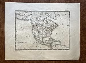
Published by Paris, Desray and J. Goujon, 1814. 1814
- Hardcover
- Map
Seller: Arader Galleries - AraderNYC, New York, NY, U.S.A.Arader Galleries - AraderNYC
Contact seller5-star sellerCondition: Used - Very good
US$ 7,000.00
Free ShippingShips within U.S.A.Quantity: 1 available
Hardcover. Condition: Very Good. Together two maps, each mounted in 12 segments on 4 linen sheets (37 4/8 x 51 inches, 42 4/8 x 51 inches respectively), each hand-coloured in outline (some minor spotting), and preserving the bookseller's engraved label and vellum tabs. Contemporary French green morocco gilt backed paper boards s…olander case. Provenance: From the collection of Harlan Nissen. Two EXCEPTIONALLY FINE maps of the African and Asian continents. The map of Africa extends to include the Arabian Peninsula and with vignettes of the Isles de France and Bourbon in the Indian Ocean. The north, south and southeast regions of the continent contain a significant amount of geographical detail, which is in sharp contrast to the vast interior which contains a significant lack of detail: a result of the lack of European exploration of the area to date. The origin on the Nile is shown as a confusing number of tributaries arising from a mountain range labeled Monts Al-Quamar (or Mountains of the Moon). The fine and detailed map of Asia extends from the Mediterranean sea in west to Amerique Russe (or Alaska) in the north-east and the Polynesian islands in the south-east; the Arctic circle in the north and the Borneo in the south. Brue was an important and prolific French cartographer, who for a time held the position of Geographe de Roi. His most significant achievement was his "Atlas Geographique, Historique, Politique et Administratif de la France" published between 1820 and 1828 and extending to 36 maps in a planned series of 48. Catalogued by Kate Hunter.

Language: French
Published by J. Andriveau, Paris 1861
- Map
Seller: Jean-Yves Bochet Après l'Iris Noir, Paris, FR, FranceJean-Yves Bochet Après l'Iris Noir
Contact seller5-star sellerCondition: Used - Fine
US$ 117.21
US$ 23.90 shippingShips from France to U.S.A.Quantity: 1 available
Condition: Très bon. J. Andriveau, 1861, carte 100 x 72 cm, pliée sous chemise percaline bleue éditeur. Carte entoilée. Nouvelle édition rectifiée d'après les travaux de la Nouvelle Carte de France. Parfait état.
 More images
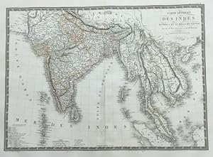
Published by Paris Institut Geographique de Paris 1821 1821
- Map
Seller: Harrison-Hiett Rare Books, Richelieu, FranceHarrison-Hiett Rare Books
Contact seller4-star sellerCondition: Used
US$ 81.58
US$ 39.83 shippingShips from France to U.S.A.Quantity: 1 available
Engraved & Hand coloured map of India, Korea, Cambodia, Vietnam etc. Published in Atlas Universel De Geographie Physique, Politique, Ancienne Et Moderne. Dimensions: 400 x 545 mm. (on sheet: 490 x 650 mm.) Good. Wide margins. Fold as published. Verso: blank. Contemporary border-colours. Clear impressions. Relief shown by hachure…s. Railroads. Prime meridian Paris. Six scales. Shows colonies and possessions of European and native powers. 400 x 545 mm (15¾ x 21½ inches).

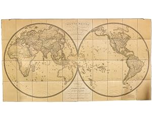
"Mappe-Monde en deux Hemispheres" - Weltkarte World Map Australia America China Russia Philippines / Karte map carte
Jean-Baptiste-Pierre Tardieu (1746-1816) und Adrien-Hubert Brué (1786-1832):
Language: French
Published by Paris, Desray 1816
- Map
Seller: Antiquariat Steffen Völkel GmbH, Seubersdorf, GermanyAntiquariat Steffen Völkel GmbH
Contact seller5-star sellerCondition: Used
US$ 210.97
US$ 34.14 shippingShips from Germany to U.S.A.Quantity: 1 available
Seltene großformatige, handkolorierte Kupferstich-Karte gestochen von Jean-Baptiste-Pierre Tardieu nach einer Zeichnung von Brué. -- Blatt-Maße: ca. 46 x 68 cm. -- gut erhalten. || Rare large-format handcolored engraved map engraved by Tardieur after Brué . -- in very good condition. // Wir, das Antiquariat Steffen Völkel, kaufe…n und verkaufen alte Bücher, Handschriften, Zeichnungen, Autographen, Grafiken und Fotografien. Wir sind stets am Ankauf von kompletten Bibliotheken, Sammlungen und Nachlässen interessiert. Sprache: Französisch Gewicht in Gramm: 35.

"Oceanie ou cinquieme partie du monde comprenant l'Archipel d'Asie, l'Australasie, la Polynesie etc." - Oceania Ozeanien Australia Philippines Indonesia New Zealand America Philippinen Indonesien Neuseeland Amerika / Karte map carte
Jean-Baptiste-Pierre Tardieu (1746-1816) und Adrien-Hubert Brué (1786-1832):
Language: French
Published by Paris, Desray 1814
- Map
Seller: Antiquariat Steffen Völkel GmbH, Seubersdorf, GermanyAntiquariat Steffen Völkel GmbH
Contact seller5-star sellerCondition: Used
US$ 234.41
US$ 34.14 shippingShips from Germany to U.S.A.Quantity: 1 available
Seltene großformatige handkolorierte Kupferstich-Karte gestochen von Jean-Baptiste-Pierre Tardieu nach einer Zeichnung von Adrien-Hubert Brué. -- Blatt-Maße: ca. 57,5 x 82 cm. -- gut erhalten. || Rare large format handcolored map engraved by Tardieur after Adrien-Hubert Brué. -- in very good condition. // Wir, das Antiquariat St…effen Völkel, kaufen und verkaufen alte Bücher, Handschriften, Zeichnungen, Autographen, Grafiken und Fotografien. Wir sind stets am Ankauf von kompletten Bibliotheken, Sammlungen und Nachlässen interessiert. Sprache: Französisch Gewicht in Gramm: 30.
 More images
Language: French
Published by Brue, Paris 1821
- Map
Seller: Bjarne Tokerud Bookseller, Vancouver, BC, CanadaBjarne Tokerud Bookseller
Contact seller5-star sellerAssociation member: PBFA
Condition: Used - Very good
US$ 250.00
US$ 20.00 shippingShips from Canada to U.S.A.Quantity: 1 available
No Binding. Condition: Very Good. Paris: Brue, January 1821. Engraved map, 27" x 20.5". Contemporary colouring in outline. A nice clean copy. At top right: Atlas Universel Pl. 33.

Language: French
Published by Paris 1826
- Map
Seller: Anah Dunsheath RareBooks ABA ANZAAB ILAB, Auckland, NZ, New ZealandAnah Dunsheath RareBooks ABA ANZAAB ILAB
Contact seller5-star sellerCondition: Used - Very good
US$ 720.47
US$ 25.00 shippingShips from New Zealand to U.S.A.Quantity: 1 available
Unbound. Condition: Very Good. Orignal, hand-coloured engraved map of New Holland (Australia) with distorted map of New Zealand, at bottom right wiht a lot of detail, New Guinea & other Pacific Islands. Each Australian region is named: Terre de Gran, Baudin, Flinders, Nuyts, Leuwin, d'Edel, Dendracth, Witt, Van Diemen, d'Arnheim…, and Carpentarie. An inset of the southeast coast titled "Details d'une partie de la nouvelle Galles Meridionale" illustrates the nine divisions proposed by Captain Vetch of the Royal Corps. Image 60.5 x 36 cm, full size, 69.5 x 48 cm. Free floating & protected by mylar.Closed split on bottom margin. A very handsome, large map.
 More images
Published by Asia - Africa
Seller: Sergio Trippini, Gavirate, VA, ItalySergio Trippini
Contact seller4-star sellerCondition: Used
US$ 93.77
US$ 54.62 shippingShips from Italy to U.S.A.Quantity: 1 available
 More images
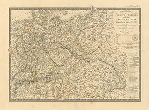
Published by Europa centrale
Seller: Sergio Trippini, Gavirate, VA, ItalySergio Trippini
Contact seller4-star sellerCondition: Used
US$ 93.77
US$ 54.62 shippingShips from Italy to U.S.A.Quantity: 1 available
Restauro alla piega centrale editoriale.


