Cartography Maps (24 results)

- Map
Seller: Orion Tech, Kingwood, TX, U.S.A.Orion Tech
Contact seller5-star sellerCondition: Used - Fair
US$ 6.50
Free ShippingShips within U.S.A.Quantity: 1 available
map. Condition: Fair. Gerald C. Hill (cover); Jim Daviner; Diana Hertz; Peter M. Mason; Ken Matthew; James Mann; Stefanie Newman; Rob Thorpe; Journey Maps; Knoll Cartography (illustrator).
Seller: World of Books (was SecondSale), Montgomery, IL, U.S.A.World of Books (was SecondSale)
Contact seller5-star sellerCondition: Used - Very good
US$ 6.51
Free ShippingShips within U.S.A.Quantity: 1 available
Condition: Very Good. Item in very good condition! Textbooks may not include supplemental items i.e. CDs, access codes etc. Gerald C. Hill (cover); Jim Daviner; Diana Hertz; Peter M. Mason; Ken Matthew; James Mann; Stefanie Newman; Rob Thorpe; Journey Maps; Knoll Cartography (illustrator).
Seller: Evergreen Goodwill, Seattle, WA, U.S.A.Evergreen Goodwill
Contact seller5-star sellerCondition: Used - Good
US$ 2.91
US$ 3.99 shippingShips within U.S.A.Quantity: 1 available
map. Condition: Good. Gerald C. Hill (cover); Jim Daviner; Diana Hertz; Peter M. Mason; Ken Matthew; James Mann; Stefanie Newman; Rob Thorpe; Journey Maps; Knoll Cartography (illustrator).

Seller: -OnTimeBooks-, Phoenix, AZ, U.S.A.-OnTimeBooks-
Contact seller5-star sellerCondition: Used - Very good
US$ 7.50
Free ShippingShips within U.S.A.Quantity: 1 available
Condition: very_good. Gently read. May have name of previous ownership, or ex-library edition. Binding tight; spine straight and smooth, with no creasing; covers clean and crisp. Minimal signs of handling or shelving. 100% GUARANTEE! Shipped with delivery confirmation, if you're not satisfied with purchase please return item! Sh…ips USPS Media Mail. Cartography By GP Maps & Benchmark Maps (illustrator).

- Softcover
- First Edition
Seller: WONDERFUL BOOKS BY MAIL, CHICO-CA, CA, U.S.A.WONDERFUL BOOKS BY MAIL
Contact seller5-star sellerCondition: Used - Very good
US$ 15.00
US$ 3.75 shippingShips within U.S.A.Quantity: 1 available
Paperback. Condition: Very Good. First Edition. VERY GOOD Condition NOT MARKED UP, CLEAN, SOLID, BRIGHT.; WHITE & BLACK TITLES ON GREEN SQUAREBACK PAPER covers.(does not have any IS BN code.presume this copy issued before hey were assigned to later printings.) ; MAPS, COLOR DRAWINGS; 48+xvi pages; .RELATIONSHIPS OF HUMAN ACTIVIT…IES O ROUTES, BOUNGARIES, SETTLEMENTS; nORTH IS NOT NECESSARILY AT TOP OF THE PAGE.CHANGING RELATIONS BETWEEN GEOGRAPHICAL ENVIRONMENT .& COMMUNITIES & COUNTRIES THEY CERATED. Illustrated by Clarendon press cartography maps (illustrator).

Language: English
Published by Nautical and Aviation Publishing Co. (1985), Baltimore, MD 1985
- Hardcover
Seller: Riverow Bookshop, Owego, NY, U.S.A.Riverow Bookshop
Contact seller5-star sellerCondition: Used
US$ 16.00
US$ 6.50 shippingShips within U.S.A.Quantity: 1 available
Leatherette w/DJ. Condition: VG/G. 2nd Edition. Baltimore, MD: Nautical and Aviation Publishing Co. VG/G. (1985). 2nd Edition. Leatherette w/DJ. Seventh printing, 1990 . Sm 4to., 110 pp., DJ rubed, frayed, tears, toning . Black & White Photographs, Maps (illustrator).

Language: English
Published by Nautical and Aviation Publishing Co. (1983), Annapolis, MD 1983
- Hardcover
Seller: Riverow Bookshop, Owego, NY, U.S.A.Riverow Bookshop
Contact seller5-star sellerCondition: Used
US$ 20.00
US$ 6.50 shippingShips within U.S.A.Quantity: 1 available
Leatherette w/DJ. Condition: G/G. Annapolis, MD: Nautical and Aviation Publishing Co. G/G. (1983). . Leatherette w/DJ. Sm 4to., 106 pp., DJ rubbed,frayed, toned, tears, cover edges rubbed, . Black & White Photographs,Maps (illustrator).

Published by The John C Winston Company 1957
- Hardcover
Seller: Bargain Finders of Colorado, Simla, CO, U.S.A.Bargain Finders of Colorado
Contact seller4-star sellerCondition: Used - Good
US$ 16.95
US$ 5.00 shippingShips within U.S.A.Quantity: 1 available
Hardcover. Condition: Good. No Jacket. Revised Edition. Privately owned copy. Interior is tight, clean and unmarked. Hardcover has grey cloth boards, with black lettering, but no DJ. Young person almanac of post WWII globe illustrated with maps, graphs and B&W photos. Of particular interest are land/sea/air routes w/ travel time… estimates between points on the globe. 392 pages plus 16 full color plate political & elevation maps of the planet. Copyrights 1954 & 1950. Printline H-1157. Printed before ISBNs, there is none. No LoC #, nor publisher's catalog. Brammell, James A. (Cartography) ;Tschirky, L. Robert (Picture Graphs) ;Pearcy, G. Etzel (Air Route Maps) (illustrator).
 More images
Language: English
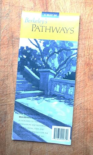
Published by Berkeley PATH Wanderer's Assoc, Berkeley, CA 2005
- Softcover
Seller: 100POCKETS, Berkeley, CA, U.S.A.100POCKETS
Contact seller4-star sellerCondition: New
US$ 36.50
US$ 7.50 shippingShips within U.S.A.Quantity: 1 available
Paperback/Folding Map. Condition: New. Dust Jacket Condition: None as Issued. 3rd Edition. BRAND NEW Copy. 3rd Edition, 2005. Folding map to the 136 paths, steps & walkways of Berkeley, California maintained by the city's Departments of Public Works and of Parks, Reacreation & wATERFRONT. 7. Included are their official names & a…ssigned numbers, and parts of paths extending into Oakland, Albany and Kensington. Keys to map cites Passable Paths, Impassable/Planned Paths, Wheelchair-Accessible Path, Current & Historic Streams, and connecting streets, freeways & BART Lines. Nat Case; Don Marietta (Cartography) (illustrator).

- Map
Seller: Revaluation Books, Exeter, , United KingdomRevaluation Books
Contact seller5-star sellerCondition: New
US$ 22.19
US$ 13.43 shippingShips from United Kingdom to U.S.A.Quantity: 1 available
Map. Condition: Brand New. 2 pages. 8.98x4.06x0.16 inches. In Stock. Cartography By GP Maps & Benchmark Maps (illustrator).

Published by David & Charles; Newton Abbot. 1973
- Hardcover
Seller: Sapience Bookstore, Hexham, , United KingdomSapience Bookstore
Contact seller3-star sellerCondition: Used
US$ 8.58
US$ 23.49 shippingShips from United Kingdom to U.S.A.Quantity: 1 available
Hard with Dust Jacket. Condition: Near fine in like dust jacket. First printing. Near fine in like dust jacket. 216pp. Illustrated with maps. (illustrator).
Published by Streetwise Maps Inc., Amagansett, N. Y. 11930 * * * * * 1994
- Softcover
- Map
Seller: L. Michael, North Hollywood, CA, U.S.A.L. Michael
Contact seller4-star sellerCondition: Used - Fine
US$ 17.66
US$ 15.26 shippingShips within U.S.A.Quantity: 1 available
Soft cover. Condition: Fine. Map Fine/ $24.89 WORLD TIME ZONES, MERATOR PROJECTION, the World, Robinson Projection * Streetwise Maps Inc. Michael E. BROWN, Cartography by. 1994 Amagansett, N. Y. 11930 * * * * * S/c Glossy 4 Fold Map Of The World Time Zones, In Fine/ Condition, Slightest Shelf, Edge And Corner Wear. Suitable For…Framing. D/j: None. This Item Will Be Sent Wrapped In Plastic, Taped Shut And In A = New Padded Mailing Envelope = To Prevent Shipping Damage So That It Will Arrive In The Description Described Which Applies To This Item, = ONLY. = No Odors, No Writing, No Names, No Rippling, Not Stuck Together, No Book Plate, Not X~Library, No Other Marks. = Will Make It, An Excellent Addition To Your Own Personal Library Collection, Or As A Gift, For The Discriminating Reader / Collector. = WORLD WIDE SHIPPING, AVAILABLE *. Michael E. BROWN, Cartography by. Map Fine/ 1994 (illustrator).
- Map
Seller: Revaluation Books, Exeter, , United KingdomRevaluation Books
Contact seller5-star sellerCondition: New
US$ 25.43
US$ 13.43 shippingShips from United Kingdom to U.S.A.Quantity: 1 available
Map. Condition: Brand New. map edition. 28 pages. 9.70x5.80x0.20 inches. In Stock. Gerald C. Hill (cover); Jim Daviner; Diana Hertz; Peter M. Mason; Ken Matthew; James Mann; Stefanie Newman; Rob Thorpe; Journey Maps; Knoll Cartography (illustrator).
Published by Rand McNally, New York 1951
- Hardcover
- First Edition
Seller: Rose's Books IOBA, Harwich Port, MA, U.S.A.Rose's Books IOBA
Contact seller2-star sellerCondition: Used - Near fine
US$ 30.00
US$ 6.00 shippingShips within U.S.A.Quantity: 1 available
Hard Cover. Condition: Near Fine. First Edition. New York: Rand McNally, 1951. First edition. 4to Cloth binding, 376 pp. including index. Illustrated throughout in black and white and color. Maps. No marks inside. Near fine. Size: 4to. Paulsen, Valdemar, art cartography in topographic maps (illustrator). Textbook.
- Map
Seller: Revaluation Books, Exeter, , United KingdomRevaluation Books
Contact seller5-star sellerCondition: New
US$ 41.59
US$ 13.43 shippingShips from United Kingdom to U.S.A.Quantity: 1 available
Map. Condition: Brand New. 4th edition. 27.00x1.40x1.20 inches. In Stock. Gerald C. Hill; Jim Daviner; Diana Hertz; James Mann; Peter M. Mason; Ken Matthew; Stefanie Newman; Rob Thorpe; Journey Maps; Knoll Cartography (illustrator).
 More images
- Softcover
Seller: 100POCKETS, Berkeley, CA, U.S.A.100POCKETS
Contact seller4-star sellerCondition: New
US$ 64.50
US$ 7.50 shippingShips within U.S.A.Quantity: 1 available
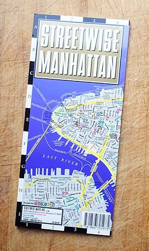
Soft Cover/Fold-out. Condition: New. Dust Jacket Condition: None as Issued. NEW. Highly regarded, laminated, 10-page, laminiated, acordion style, folding pocket-size map to the borough of Manhattan and New York City proper. Map folds out to an impressive 8-1/2" to 19-1/4" in length. Highlights to cultural site, points of interes…ts, major government offices, hospitals and churches. Both functional and appealing, makes travelling an informed pleasure. Marvellous guide. Michael E. Brown (Cartography) (illustrator).
Published by Savas Beatie, New York 2009
- Hardcover
- First Edition
- Signed
Seller: THE HERMITAGE BOOKSHOP, Denver, CO, U.S.A.THE HERMITAGE BOOKSHOP
Contact seller5-star sellerCondition: Used - Near fine
US$ 45.00
US$ 7.00 shippingShips within U.S.A.Quantity: 1 available
Hardcover, in dust jacket. Condition: Near Fine. dj. First edition, first printing. Signature plate signed by author and cartographer laid in. Near fine in fine dust jacket with light shelf wear, in mylar cover. Full page color maps. (illustrator). Signed.
Published by Newsmap Company, Chicago 1938
- First Edition
Seller: Jeffrey H. Marks, Rare Books, ABAA, Rochester, NY, U.S.A.Jeffrey H. Marks, Rare Books, ABAA
Contact seller5-star sellerIllustrated from maps in color. 8vo, single large sheet folded to form 28 pp. First edition. Light dust-soiling; otherwise fine. This unusual periodical proposed to present "in a monthly series artistic and colorful maps and stories of description to supplement the voluminous current happenings each month.".
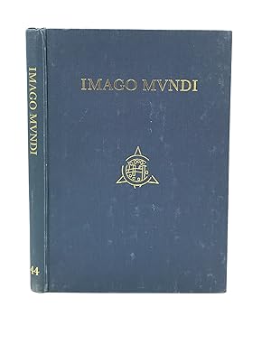
Imago Mundi The Journal of the International Society for the History of Cartography Volume 44
Toni Huber On A Tibetan Map, David Woodward, On Paola Forlani, Denis Cosgrove, On 16th C. Venice And Cartography, G. Wajntraub, On Medieval Hebrew Maps, Michelle Brown, On The Aslake World Map; More
- Hardcover
Seller: Leopolis, Kraków, PolandLeopolis
Contact seller5-star sellerCondition: Used - Very good
US$ 67.71
US$ 75.47 shippingShips from Poland to U.S.A.Quantity: 1 available
Hardcover. Condition: Very Good. 4to (30.5 cm), frontispiece in color, 178 pp. Publisher's cloth, gilt-lettered spine and front board (binding slightly rubbed and stained, bookplate tipped in verso of the title page). Contents include articles: "A Tibetan map of lHo-kha in the South-Eastern Himalayan borderlands of Tibet" by Ton…i Huber; "The Aslake world map" by Peter M. Barber & Michelle P. Brown; "Paolo Forlani: Compiler, engraver, printer, or publisher?" by David Woodward; "Mapping new worlds: Culture and cartography in sixteenth‐century Venice" by Denis Cosgrove; "L'émergence des nouvelles cartes marines: L'oeuvre de Beautemps‐Beaupré à la fin du XVIIIème et au début du XIXème siècle" by Olivier Chapuis; "Medieval Hebrew manuscript maps" by E. Wajntraub & G. Wajntraub; "The Royal Geographical Society, E. G. Ravenstein, and a map of eastern equatorial Africa-1877-1883" by Sanford H. Bederman; reports and articles, chronicle for 1991, book reviews.
Published by Cambridge, Map Collector Publications, 1987. 1987
- Hardcover
Seller: Antiquariat Thomas Rezek, München, , GermanyAntiquariat Thomas Rezek
Contact seller5-star sellerCondition: Used
US$ 45.44
US$ 51.08 shippingShips from Germany to U.S.A.Quantity: 1 available
Gr- 8°. XX pp., 1 f., 353 pp., with illustrations Original green cloth with title to front cover (parts of the jacket mounted on endpapers) Documentation an maps, atlases and globes with 25 images. - Fine clean.
Published by John Day, Reynal & Hitchcock, [1935]., New York: 1935
- Hardcover
- First Edition
Seller: Zephyr Used & Rare Books, Vancouver, WA, U.S.A.Zephyr Used & Rare Books
Contact seller5-star seller4to. xiv, 351, [1] pp. With 56 maps (most full-page), numerous text illustrations. Blue publisher's cloth, silver lettering front cover & spine (minor shelfwear, light rubbing at head & foot of spine, corners), w/ d.j. striking Art Deco cover art of ships voyaging (minor creasing, edgewear, couple closed tears on back cover, wea…r to corners), still NF/VG- copy, inscribed by author on half-title. First edition, inscribed, of this unashamedly Eurocentric voyages and exploration history detailing "all the great adventurers by land and sea from Hannu 2750 B.C. to Piccard 1935." The specially prepared maps specifically show the ground and oceans covered by each explorer, with the contemporary "Known World" starkly defined. The maps and histories sequentially "unroll" from the very small area around the Mediterranean to the World. Outhwaite (1892-1979) was an anthropologist who worked on American race relations at the Laura Spelman Rockefeller Memorial from 1923-1028, worked for the Rockefeller Foundation through the 1930's, and organized "Outhwaite Exhibits" for museums, World's Fairs, and window displays. He also was an adventurer who sailed 14,000 miles on the Atlantic Ocean from 1929-1930 onboard the yacht "Kinkajou" visiting Mt. Pelee, Martinique.
Extensive manuscript list (cartographer's probate inventory?), in a late eighteenth-century hand, docketed 'Contents of Maps, Charts, &c in the largest Box, from No. 65 to No. 166', including references to maps by John Hamilton Moore.
[John Hamilton Moore (c.1738-1807), Scottish cartographer and author; British map-making; Georgian maps; cartography]
Published by English; circa 1790
- Softcover
- Manuscript
Seller: Richard M. Ford Ltd, London, , United KingdomRichard M. Ford Ltd
Contact seller5-star sellerCondition: Used
US$ 622.26
US$ 6.04 shippingShips from United Kingdom to U.S.A.Quantity: 1 available
8vo, 6 pp. Two bifoliums sewn together. On laid paper with Britannia watermark. Text clear and complete. Neatly written out at approximately 38 lines to the page. On aged paper, with slight damage to the first bifolium, the leaves of which are detaching at the spine. Some of the items have been lightly scored through in pencil,…but are still legible. The inclusion of such items as '149 Blank Silk Paper for copying Maps' would appear to indicate that the document is an inventory (for probate?) of a cartographer's stock. Last two entries read '165 Blank Sheets of Paper for copying Maps. A Bond relating to the Honble. Thomas Howe. Prints to copy from. Several Plans of the River and Sound of Dawfoskee in South Carolina, survey'd by Captn. Gascoigne. | 166 Draught of Falklands Islands. Map of the Province of New York. La Cours de la Meuse. The Circle of the Inferior Rhine. Plans of Port Royal in South Carolina. Les Duchés de Lorraine & De Bar. Plans of the River & Sound of Dawfoskee in South Carolina.' The first two entries list items by John Hamilton Moore, a Scottish cartographer who, according to his obituary in the Gentleman's Magazine, was 'late teacher of Navigation on Tower-Hill, author of Moore's Navigation, Seaman's Daily Assistant, the Monitor, &c.'.
 More images
[A BOUND VOLUME CONTAINING TEN PAMPHLETS. ESSAYS ON CARTOGRAPHY, ALL INSCRIBED BY THE AUTHOR].
[Cartography, Maps; European History]; Fordham Sir Herbert George.
Published by Various places. Various publishers 1908 to 1923 1923
- Softcover
Seller: Buddenbrooks, Inc., Newburyport, MA, U.S.A.Buddenbrooks, Inc.
Contact seller5-star seller10 volumes bound together in one volume. First Editions and all but one are inscribed by the author. Illustrated with cartographic cover art, re-impressions of important works, cartographic decorations and a number of maps including a number that are folding. 8vo, the original printed wraps to each pamphlet are present and all a…re bound into the one cloth covered volume, brown morocco label gilt. Each pamphlet can be considered fine and in exemplary condition, some evidence of use and a bit of age to the cloth covers. A fine collection. A FINE COLLECTION OF INSCRIBED FIRST EDITIONS. Ranging from the cartography of the provinces of France 1594 to British and Irish Itineraries and Road-Books, English Counties, Welsh, a pamphlet on the Evolution of the Maps of the Bristish Isles, on the great engraver and mapmaker John Cary, and two on France cartography and routes from the mid-1500's until the middle of the 19th century. ALL BOOKS ARE INSCRIBED BY THE AUTHOR.
 More images
- Hardcover
- Print on Demand
Seller: Gyan Books Pvt. Ltd., Delhi, , IndiaGyan Books Pvt. Ltd.
Contact seller5-star sellerCondition: New
US$ 50.84
Free ShippingShips from India to U.S.A.Quantity: Over 20 available
Leather Bound. Condition: New. Language: English. Language: English. Presenting an Exquisite Leather-Bound Edition, expertly crafted with Original Natural Leather that gracefully adorns the spine and corners. The allure continues with Golden Leaf Printing that adds a touch of elegance, while Hand Embossing on the rounded spine l…ends an artistic flair. This masterpiece has been meticulously reprinted in 2024, utilizing the invaluable guidance of the original edition published many years ago in 1901. The contents of this book are presented in classic black and white. Its durability is ensured through a meticulous sewing binding technique, enhancing its longevity. Imprinted on top-tier quality paper. A team of professionals has expertly processed each page, delicately preserving its content without alteration. Due to the vintage nature of these books, every page has been manually restored for legibility. However, in certain instances, occasional blurriness, missing segments, or faint black spots might persist. We sincerely hope for your understanding of the challenges we faced with these books. Recognizing their significance for readers seeking insight into our historical treasure, we've diligently restored and reissued them. Our intention is to offer this valuable resource once again. We eagerly await your feedback, hoping that you'll find it appealing and will generously share your thoughts and recommendations. Lang: - English, Pages: : - 601, Print on Demand. If it is a multi-volume set, then it is only a single volume. We are specialised in Customisation of books, if you wish to opt different color leather binding, you may contact us. This service is chargeable. Product Disclaimer: Kindly be informed that, owing to the inherent nature of leather as a natural material, minor discolorations or textural variations may be perceptible. Explore the FOLIO EDITION (12x19 Inches): Available Upon Request. 601 601.


