Order Total (1 Item Items):
Shipping Destination:

Chace Jacob (1 results)
Skip to main search results
Search filters
Product Type
- All Product Types
- Books (1)
- Magazines & Periodicals (No further results match this refinement)
- Comics (No further results match this refinement)
- Sheet Music (No further results match this refinement)
- Art, Prints & Posters (No further results match this refinement)
- Photographs (No further results match this refinement)
- Maps (No further results match this refinement)
- Manuscripts & Paper Collectibles (No further results match this refinement)
Condition Learn more
- New (No further results match this refinement)
- As New, Fine or Near Fine (No further results match this refinement)
- Very Good or Good (No further results match this refinement)
- Fair or Poor (No further results match this refinement)
- As Described (1)
Binding
- All Bindings
- Hardcover (No further results match this refinement)
- Softcover (No further results match this refinement)
Collectible Attributes
- First Edition (No further results match this refinement)
- Signed (No further results match this refinement)
- Dust Jacket (No further results match this refinement)
- Seller-Supplied Images (1)
- Not Print on Demand (1)
Language (1)
Price
- Any Price
- Under US$ 25 (No further results match this refinement)
- US$ 25 to US$ 50 (No further results match this refinement)
- Over US$ 50
Free Shipping
Seller Location
Seller Rating
-
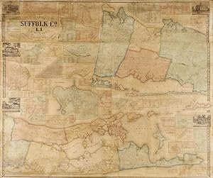
Map of Suffolk Co., L. I., New York. From Actual Surveys by J. Chase Junr.
Published by Philadelphia: J. Douglass, 1858, 1858
Seller: Arader Galleries - AraderNYC, New York, NY, U.S.A.
Seller rating 5 out of 5 stars

Hand-colored lithographed wall-map on four joined sheets (49 x 57 � inches). Remounted on modern linen on original wooden rollers (general discoloration, browning, puckering, short closed tears expertly repaired, rolls nicely). THE MOST DETAILED MAP OF 19TH CENTURY SUFFOLK COUNTY FROM HUNTINGTON TO THE HAMPTONS. The level of detail on this map is incredible, including the names of every single residence, workplace, church, and school in the county. In addition to this essential survey of 19th century Long Island life, the geographical scale is total and complete. Perhaps the most accurate map of the area until the 20th century. Undertaken with the collaboration of the Smith-French survey of New York, the most ambitious and advanced mapping project for any American state to that date. Due to Suffolk County's long and narrow form, Chace chose to divide the map into two parts, with the western part of the county shown at top, and the eastern at bottom. Interspersed are thirty-three inset plans of Suffolk towns, including Southampton, Easthampton, Bridgehampton, Amangansett, Sag Harbor, Riverhead, Islip, Stoneybrook (sic), Sayville, Patchogue, Smith Town, Amityville, and Greenport. For all inquiries please contact Greg McMurray, MLS, Director, Rare Books.