Order Total (1 Item Items):
Shipping Destination:

Champlain Sieur (7 results)
Skip to main search results
Search filters
Product Type
- All Product Types
- Books (6)
- Magazines & Periodicals (No further results match this refinement)
- Comics (No further results match this refinement)
- Sheet Music (No further results match this refinement)
- Art, Prints & Posters (No further results match this refinement)
- Photographs (No further results match this refinement)
- Maps (1)
- Manuscripts & Paper Collectibles (No further results match this refinement)
Condition Learn more
- New (No further results match this refinement)
- As New, Fine or Near Fine (1)
- Very Good or Good (5)
- Fair or Poor (No further results match this refinement)
- As Described (1)
Binding
- All Bindings
- Hardcover (6)
- Softcover (No further results match this refinement)
Collectible Attributes
- First Edition (4)
- Signed (No further results match this refinement)
- Dust Jacket (No further results match this refinement)
- Seller-Supplied Images (6)
- Not Print on Demand (7)
Language (1)
Free Shipping
Seller Location
Seller Rating
-

Hard cover. Reprint. BARNES AND NOBLE, 1967. Reprint. . Good. Ex-library. VERY CLEAN, CRISP. 374 p. Includes: maps, index. loc voyages Good. Ex-library. VERY CLEAN, CRISP.
-
Hardcover. Condition: Very Good. Octavo (5 15/16" x 4", 151mm x 101mm): [Full collation available on request] 166 leaves, pp. [16] (engraved half-title, blank, title, blank, 8pp. dedication to the king, 3pp. preface, copyright) leaves numbered 1-158 to the recto. With 1 folding plate (out of two) and 4 full page engraved plates. Bound in modern green calf. On the spine, 5 raised bands. "CHAMPLAIN / VOYAGES" gilt to orange morocco in the second panel. Date gilt to the heel. With gilt dentelles and green marbled endpapers. Presented in a slipcase of green card. Engraved half-title chipped at the extremities and infilled at the gutter. Dampstaining to the lower fore-corner throughout the first quire (8 leaves). Lacking the first of two folding plates (a settlement depiction) but an older facsimile -- evidenced by offsetting from its previous neighbor text to the verso -- takes its stead. Scattered marginalia throughout. Bookplate of Ernest E. Keet completed in ink manuscript "10795" to the recto of the first free endpaper. Nautical stamp of the Admiralty Office Library and ink inscription "Ex lib. P. de cardonnel. 1661" to �1 recto. Manuscript inscription of William Lowth along the fore margin of D7 recto. Inscription to V6 verso obscured by a support leaf. Samuel de Champlain (1567-1635) came of age in a time of tremendous religious unrest, political chaos, and endemic warfare, due to the civil wars which raged throughout the kingdom of France at the time of his birth. Little is known about the minutiae of his childhood, but his father was a sailor, and Samuel verifiably became a soldier. In the late 1590s, Champlain served in King Henry IV's army during the Wars of Religion in Brittany. As a quartermaster and, later, a company captain, he developed a reputation for discipline, discretion, and intelligence; secondary literature from the XVII and XVIIIc often describes Champlain during his tour of duty not as a man, but a saint. Following the war and on the cusp of a new century, King Henry IV entrusted the now-revered Champlain with a voyage to the Spanish colonies in the Caribbean. Champlain disguised himself as a merchant and spent two years observing fortifications, colonial practices, and the imperial mechanisms of the New World. Though his visit was unofficial, Champlain shared intelligence collected on New Spain with the French court. Perhaps it was this stint in the colonies that spurred a desire to explore lands yet unknown to the Old World. Throughout the first decade of the XVIIc, Champlain undertook four major voyages to North America (see our first edition example of these expeditions). During his travels, he explored the region of the St. Lawrence River, attempted to colonize Acadia (modern-day Nova Scotia and New Brunswick), and established the permanent colony and trading post of Qu�bec city, which would become the capital of Nouvelle-France. Between 1615 and 1618, Samuel de Champlain led his final major expedition into the interior of New France. The present example details this voyage, which centers around Champlain's travels to the Great Lakes region, specifically Lake Huron (Mer douce). The journey involved a raid against the Iroquois, during which Champlain was shot in the leg and subsequently spent a bitter winter with the Huron-Wendat tribe on the southeastern shores of Georgian Bay. His misfortune proved intellectually fruitful, as Champlain was able to spend an extended period with the tribes of present-day Canada, developing alliances and recording ethnographic observations. No stranger to Louis XIII's personal interest in Native customs, Champlain spends much of the account relaying their ceremonies, healing practices, cannabis habits, and sexual culture, perhaps in part to encourage continued patronage. Voyages et descouvertures was first published in 1619 in France and painted an intimate portrayal of indigenous society that not only shaped colonial policy and ideological narratives within the court but influenced the popular imagina.
-
Quatriesme voyage du Sr de Champlain Capitaine Ordinaire pour le Roy en la marine, et Lieutenant de Monseigneur le Prince de Cond� en la Nouvelle France, fait en l'annee 1613
Published by Jean Berjon, Paris, 1613
First Edition
Hardcover. Condition: Very Good. First Edition. Quarto (9" x 6 11/16", 230mm x 170mm): [Full collation available on request]. 26 leaves, pp. 1-2 3-52. With woodblock initials and headpieces. Bound in modern speckled calf. Blind fillet and rolled paneling, blind corner ornamentation, and blind superlibros to the boards. On the spine, four raised bands. Some rodent nibbling to the lower fore-corner throughout, not affecting the text. Excerpted from Les Voyages de Sieur de Champlain Xaintongeois and rebound to stand alone. Bookplate of Ernest E. Keet, completed in ink manuscript "10780," to the recto of the first free endpaper. Samuel de Champlain (1567-1635) was the great French navigator-explorer of Canada, founder of Quebec City and governor of Nouvelle France (the whole of the French colonial territory in America, less Acadia, Louisiana and the cities of Trois-Rivi�res and Montr�al). Champlain came of age in a time of tremendous religious unrest, political chaos, and endemic warfare, due to the civil wars which raged throughout the kingdom of France at the time of his birth. Little is known about the minutiae of his childhood, but his father was a sailor, and Samuel verifiably became a soldier. In the late 1590s, Champlain served in King Henry IV's army during the Wars of Religion in Brittany. As a quartermaster and, later, a company captain, he developed a reputation for discipline, discretion, and intelligence; secondary literature from the XVII and XVIIIc often describes Champlain during his tour of duty not as a man, but a saint. Following the war and on the cusp of a new century, King Henry IV entrusted the now-revered Champlain with a voyage to the Spanish colonies in the Caribbean. Champlain disguised himself as a merchant and spent two years observing fortifications, colonial practices, and the imperial mechanisms of the New World. Though his visit was unofficial, Champlain shared intelligence collected on New Spain with the French court. Perhaps it was this stint in the colonies that spurred a desire to explore lands yet unknown to the Old World. Throughout the first decade of the XVIIc, Champlain undertook four major voyages to North America (see our first edition example of these expeditions). During his travels, he explored the region of the St. Lawrence River, attempted to colonize Acadia (modern-day Nova Scotia and New Brunswick), and established the permanent colony and trading post of Qu�bec city, which would become the capital of Nouvelle-France. The present edition is the first appearance of Champlain's 1613 voyage to the Ottawa River Valley. Prior to this fourth voyage, Champlain had set the publication of Les Voyages du Sieur de Champlain Xaintongeois underway while in Paris. He ventured out again and reached the mouth of the Ottawa River in May of 1613. After a summer of exploring the region, he returned to Paris in October, where the publication of his 1604, 1610, and 1611 voyages were still a work in progress. This final section was incorporated with separate pagination and its own section title, and the complete text was released by Jean Berjon later that year. Ernest "Lee" Keet, a longtime resident of Saranac Lake, New York, comes from a family with deep roots in the Adirondack region, where his ancestors have lived since 1805. An engineer by training and a private equity investor by profession, Keet has maintained and enriched his family's legacy through active engagement in regional development and cultural preservation. Beginning in the 1980s, he assembled a significant collection of rare books, with a focus on early French and English exploration in the American Northeast, as well as the history and natural heritage of the Adirondacks.Alden & Landis 613/30; Church 360; Sabin 11835. Cataloged by G.R. Murdock.
-
Hardcover. Condition: Very good. First. THE ULTIMATE SET OF CANADIAN AMERICANA. Champlain's 1613 account of his first four voyages to New France, and his comprehensive 1632 revision of the account up to 1631, including some of the most important and influential maps of the New World. The 1613 first edition is quite rare, and in exceptional state (with two maps supplied in facsimile). The 1632 revised edition, one of the great treatises on the topography, flora & fauna, people and climate of North America before extensive European settlement, is an exceptionally distinguished copy in a contemporary armorial binding. There can be no greater pair to establish (or to crown) a collection of Americana, Canadiana or Voyages. Please see the listings for the individual copies for full descriptions, or inquire to be sent a complete collation and description of both copies.
-
Hardcover. Condition: Very good. First. First edition. Paris: Chez Iean Berjon, 1613. Quarto (8 1/2" x 6 9/16", 216mm x 167mm). [Full collation available.] With 11 folding engraved plates (of which 8 are maps, of which 2 are facsimiles) plus 13 in-text engravings and 1 in-text woodcut. Bound in 1889 by W. Pratt for H. Stevens & Son in red morocco (rebacked, with the original backstrip laid down). On the covers, a triple gilt fillet border surrounding a triple-gilt fillet panel, with outside-corner gilt fleurons and inside-corner gilt branch-sprays. On the spine five raised bands with a gilt fillet. Gilt florals in the panels. Title gilt to the second panel, imprint gilt to the third panel. Five pairs of gilt fillets to the head- and tail-pieces. Double gilt fillet to the edges of the boards. Gilt inside dentelle. Marbled end-papers. All edges of the text-block gilt. Rebacked, with the original backstrip laid down. Fore-corners restored. Two maps (Burden 160 & 170) present only in facsimile. Evenly mildly tanned throughout. With a couple of early ink annotations to the dedicatory poem (?1r-v). Some scattered marginal repairs. A lovely copy in a sumptuous binding. Samuel de Champlain (1567-1635) was the great French navigator-explorer of Canada, founder of Quebec City and governor of Nouvelle France (the whole of the French colonial territory in America, less Acadia, Louisiana and the cities of Trois-Rivi�res and Montr�al). The present item is the first published account of his voyage to and exploration of the northern part of France's vast American territory in the XVIIc, which would essentially collapse by 1763. Though Champlain would go on to traverse the Atlantic some two dozen times, here he includes accounts of his four voyages to America: 1604, 1610, 1611 and 1613. Champlain was, as Burden notes, "the first truly scientific cartographer of North America," and a crucial player in France's territorial expansion on the continent. Although one of the celebrated maps is in facsimile, the other vital map ("Carte geographique de la Novelle franse en sonaray meridien") is present in the second state, with the Ottawa River depicted (Burden 161). His maps are festooned with flora and fauna, indicating to France the limitless bounty of the New World; their aim is not just historical but political and persuasive. Church 360; Burden 161, 166-169, 171-181; Sabin 11835.
-
Les Voyages de la Nouvelle France occidentale, dicte Canada, faits par le S.r de Champlain Xainctongeois, Capitaine pour le Roy en la Marine du Ponant, & toutes les Descouvertes qu'il a faites en ce pa�s depuis l'an 1603 iusques en l'an 1629. avec ce qui s'est pa�� en ladite Nouvelle France en l'ann�e 1631
Published by Chez Louis Sevestre, Paris, 1632
Hardcover. Condition: Very good. Second. Revised edition, second state. Paris: Chez Louis Sevestre, 1632. Quarto (8 7/8" x 6 7/16", 206mm x 163mm). [Full collation available.] With six in-text engraved plates, two in-text woodcuts and a large folding engraved map. Bound in contemporary armorial calf. On the boards, a double gilt fillet border. Gilt supralibros of Marc-Antoine du Sauzay. On the spine, four raised bands. In the panels, a gilt central fleuron within a double gilt fillet border. Title (VOYAGES/DE.CHAM.) gilt to the second panel. Gilt rolls to the head- and tail-pieces. Gilt rolls to the edges of the boards. All edges of the text-block speckled red. Wear along the front hinge, with a patch of wear at the upper edge of the front board. Some cracking and sunning to the spine. Some skinning to the boards. A little rubbing to the extremities. Internally some foxing, with passages of even tanning. Marginal repairs to T4 and 3G3 (affecting a few letters, supplied in manuscript). A few repaired tears to the map, but very good. Effaced bookplates of the Biblioth�que [.] (post-1802) and of the Biblioth�que du Chateau [.] to the front paste-down. Bookseller ticket of Libraire Thomas-Scheler Paris to the front paste-down. Signed bookplate of Bruce McKinney designed and printed by E.M. Ginger. Samuel de Champlain (1567-1635) was the great French navigator-explorer of Canada, founder of Quebec City and governor of Nouvelle France (the whole of the French colonial territory in America, less Acadia, Louisiana and the cities of Trois-Rivi�res and Montr�al). The first account of his voyages was published in 1613, but the present item is revised all the way to the year before its publication, and is considerably augmented (Church calls this "perhaps the most important of the old editions"). The work did much to encourage the colonization and settlement of New France. The cancellation of D2.3 is found in most copies, being a revision to remove a potentially offensive passage to Cardinal Richelieu, who preceded Champlain as governor. Church notes that several imprints are found, but that the work itself is identical. The map, stretching as far south as Virginia, is an improvement on Champlain's 1616 map, with much more detailed and accurate topography. It is also perhaps the first representation of a settlement in New York City: a church at the southern end of a peninsular Manhattan. At the end is Champlain's guide to navigation, based on his roughly two dozen crossings of the Atlantic. In addition to Champlain's accounts, there are parallel (French-"Canadois" i.e., Huron-Wyandot) religious texts by the Jesuit Ledesme: a catechism translated by Brebuf (SJ), and a series of prayers (Paternoster, Ave Maria, Creed etc.) translated by Mass� (SJ). The binder, Marc-Antoine du Sauzay (Sausay, Sausey), seigneur de Varennes, la Moli�re et Jarnosse (1622-1708) was a king's counselor and pr�v�t des marchands (not unlike the mayor) of Lyon, among other honors. He was just the sort of person who would have had curiosity about or indeed financial interests in Canada. (The supralibros bears the monogram CDS, his father Claude du Sauzay; he used the same stamp but added the laurel wreath as a mark of difference.) The next known owner was Pierre S. du Pont III (1911-1988; his sale, Christie's New York, 8 October 1991, lot 39), member of the distinguished Delaware family synonymous with gunpowder and now broader chemical manufacture. Champlain was the nephew and prot�g� of Fran�ois Grav� du Pont, but the families are not related. His Christie's sale was a formidable collection of navigation and voyages. The book then passed into the collection of Bruce McKinney (Bloomsbury New York, 3 December 2009 "The De Orbe Novo Collection: Exploration in the New World", lot 69). McKinney founded the Americana Exchange, now Rare Book Hub, the central database of book auction records. Church 420, Field 268, Harrisse 51, Lande 118 (lacking the map), Sabin 11839, Streeter VI:3621.
-
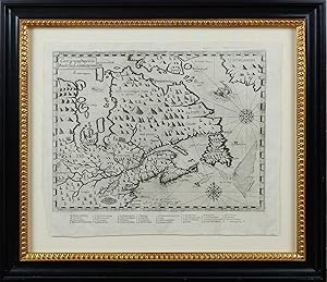
Carte geographique de la Nouelle franse en son vray meridiein
Published by Iean Berjon, Paris, 1613
Map First Edition
No binding. Condition: Near fine. First. First edition, second state. From Les Voyages du Sieur de Champlain Xaintongeois. . . Paris: Chez Iean Berjon, 1613. Copperplate engraving on a single sheet (12 1/8" x 14 7/8", 308mm x 379mm; neat-line: 240mm x 323mm). Framed floating behind Museum Glass. A dark impression with plate tone. Not viewed out of frame. Samuel de Champlain (1567-1635) was the great French navigator-explorer of Canada, founder of Quebec City and governor of Nouvelle France (the whole of the French colonial territory in America, less Acadia, Louisiana and the cities of Trois-Rivi�res and Montr�al). The present item is the first published account of his voyage to and exploration of the northern part of France's vast American territory in the XVIIc, which would essentially collapse by 1763. Though Champlain would go on to traverse the Atlantic some two dozen times, here he includes accounts of his four voyages to America: 1604, 1610, 1611 and 1613. Champlain was, as Burden notes, "the first truly scientific cartographer of North America," and a crucial player in France's territorial expansion on the continent. The present map is in Burden and Kershaw's second state, distinguishable by the changed title (".en son vray mondia" in the first state), by the sea-monster between Greenland and Labrador (a ship in the first state) and the addition for the first time of Champlain's name at bottom center ("Faictte par le Sr Champlain Cappine po~ le Roy en la marine-- 1613"). Kershaw opines that "the publisher had already started to print this map when Champlain returned to France in 1613 with additional information on the location of the Ottawa River, as well as on the Indian tribes of the Ottawa Valley." Indeed, the second state of the map contains considerably more detail about the region south of Hudson's Bay (its label in English as "the bay wher hud/son did winter"), especially noting mountains and ranges that could frustrate further exploration. Burden (ad loc.) notes that the present map "depicts latitude but longitude also, something virtually never attempted before on a North American map of such detail. Champlain's acute awareness of the deviation of the compass enables him to portray the St. Lawrence River in its more correct south-west to north-east flow rather than the more usual west to east seen on maps of the period." Burden 161; Kershaw, Early Printed Maps of Canada 62.


![Seller image for Les Voyages du Sieur de Champlain Xaintongeois, Capitaine ordinaire pour le Roy, en la marine. Divisez en deux livres. ou, Iournal tres-fidele des observations faites �s descouvertes de la Nouvelle France: tant en la descriptio[n] des terres, costes rivieres, ports, havres, leurs hauteurs, & plusieurs declinaisons de la guide-aymant; qu'en la creace des peuples, leur super-stition, fa�on de vivre & de guerroyer: enrichi de quantit� de figures. Ensemble deux cartes geographiques: la premiere servant � la navigation, dress�e selon les compas qui nordestent, sur lesquels les marinier navigent: � laquelle est adioust� le voyage du destroict qu'ont trouv� les Anglois, au dessus de Labrador, depuis le 53e. degr� de latitude, iusques au 63e. en l' for sale by Arader Books](https://pictures.abebooks.com/inventory/md/md30884498316.jpg)