Chatelaine Henri (14 results)
Published by Chatelaine, Henri, Paris 1719
- Map
Seller: mediumraremaps.com, Franklin, TN, U.S.A.mediumraremaps.com
Contact seller5-star sellerCondition: Used - Very good
US$ 125.00
US$ 6.00 shippingShips within U.S.A.Quantity: 1 available
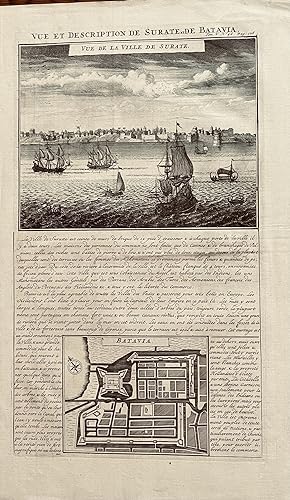
8 1/2 x 14 3/4 inches. Condition: Very good. Engraved and executed for Chatelaine's compendium of the world. Two illustrations: the inset view of Surate and the map of Jakarta.

Published by Henri Chatelaine, Paris 1719
- Art Print
Seller: mediumraremaps.com, Franklin, TN, U.S.A.mediumraremaps.com
Contact seller5-star sellerCondition: Used - Very good
US$ 145.00
US$ 6.00 shippingShips within U.S.A.Quantity: 1 available
17 x 14 1/2 inches. Condition: Very good condition. This is a fine engraving of the animals of Guinea. It includes birds, mammals and reptiles. There are two inset views The one on the left havinga large elephant as the centerpiece. The other showing inhabitant fighting and capturing large lizards or the likes.There are numerous… explanatory texts in French.

Published by Chatelaine, Henri, Amsterdam 1719
- Map
Seller: mediumraremaps.com, Franklin, TN, U.S.A.mediumraremaps.com
Contact seller5-star sellerCondition: Used - Very good
US$ 175.00
US$ 6.00 shippingShips within U.S.A.Quantity: 1 available
24 3/4 inches x 18 1/2 inches. Condition: Very good. Fine copper plate engraving of the German empire. At the time it included Switzerland, Poland Austria in the form of an antique map., Germany, Holland, Belgium and Luxembourg.The towns are colored red making this rare map an overall superior visual experience. Chatelaine was a… major producer od a seven volume set of illustrated history of the world. His maps are highly collectable and most informative.

Published by Henri Chatelaine, Paris 1719
- Map
Seller: mediumraremaps.com, Franklin, TN, U.S.A.mediumraremaps.com
Contact seller5-star sellerCondition: Used - Very good
US$ 250.00
US$ 6.00 shippingShips within U.S.A.Quantity: 1 available
20 1/2 x 16 1/2 inches. Condition: Very good condition. Definitive map of the Islands of North America particularly Jamaica. This very nice engraving was executed over three centuries ago. It is all encompassing for its time period. There is the island of Jamaica and seven inset maps as follows: Iles des Barbades, Nouvelle Angll…eterre et Nouvel York, Isle des Bermudes, Nouvelle Carte de la Caroline, Nouvell Carte des le Pensylvanie, Maryland Virginia et Nouvelle Jarsey , and Partie de la Amerique Septentrionale. Also within the Jmaique map is an inset of Caribbean Basin. This map was part of Chatelaine's encyclopedic attempt to catalofgue of the world. It was characterized by scholarship recorded in fine engraving and printing on high quality paper.

Published by Chatelain, Paris 1719
Seller: mediumraremaps.com, Franklin, TN, U.S.A.mediumraremaps.com
Contact seller5-star seller17 3/4 x 13 3/4. Fine engraving hand colored in wash. Three inset views across the upper 1/3 of the page with textual description of the Sultans administration, officers and clerics.Overall a very nice print with. Very good condition with old color. Chatelain (illustrator).

Published by Henri Chatelaine, Paris 1738
- Art Print
Seller: mediumraremaps.com, Franklin, TN, U.S.A.mediumraremaps.com
Contact seller5-star sellerCondition: Used - Very good
US$ 250.00
US$ 6.00 shippingShips within U.S.A.Quantity: 1 available
17 1/4 x 14 5/8 inches. Condition: Very good. Detailed engraving of the manners and customs of Native Americans as found in Virginia. Beautiful engraved in great detail with descriptive text in /French integrated into the presentation. Attractive later color was added.

Published by Henri Chatelaine, Paris 1719
- Map
Seller: mediumraremaps.com, Franklin, TN, U.S.A.mediumraremaps.com
Contact seller5-star sellerCondition: Used - Very good
US$ 250.00
US$ 6.00 shippingShips within U.S.A.Quantity: 1 available
19 1/4 x 14 3/4 inches. Condition: Very good. This map is a description and illustration of the.course of the Nile. It was finely engraved and printed on paper over three centuries ago. Chatelaine produced a compendium of the world and its highlights over a twenty year period ostrting in 1719. Please see pic.

Published by Chatelaine, Henri, Paris 1719
- Map
Seller: mediumraremaps.com, Franklin, TN, U.S.A.mediumraremaps.com
Contact seller5-star seller22 3/4 x 19 3/4 inches. Copperplate engraving of Russian territories from Europe through Asia. The map runs from Lithuania in the west and Korea in the east. It covers from Novelle Zemble in the north to Etats di Mogul in the south. This is a superb map from the time of Peter the Great. Very good with an occasional repaired tear… in the margin. Trimmed close to the upper external neatline with the same in the lower left corner, both by the original binder.
Published by Chatelaine, Henri, Paris 1719
- Map
Seller: mediumraremaps.com, Franklin, TN, U.S.A.mediumraremaps.com
Contact seller5-star sellerCondition: Used - Very good
US$ 300.00
US$ 6.00 shippingShips within U.S.A.Quantity: 1 available
17 1/2 x 13 1/2 inches. Condition: Very good +. Hand colored engraved view of Stockholm. This mid-eighteenth century engraving was executed by a fine hand and presented the surrender panorama. Water surrounds the city in the foreground with windmills in the far distance. Period costumed individuals are artistically placed forefr…ont. A very nice composition. Chatelaine (illustrator).

Published by Chatelaine, Henri, Paris 1719
- Map
Seller: mediumraremaps.com, Franklin, TN, U.S.A.mediumraremaps.com
Contact seller5-star sellerCondition: Used - Very good
US$ 300.00
US$ 6.00 shippingShips within U.S.A.Quantity: 1 available
17 3/4 x 13 1/2 inches. Condition: Very good +. Highly detailed set of three views focused on Copenhagen. This superb mid-eighteenth centuryengraving is representative of a sea-powered economy with notable dignitaries in the foreground and the city of Copenhagen laid out across the background. Chatelaine (illustrator).

Published by Henri Chatelain, Paris 1719
Seller: mediumraremaps.com, Franklin, TN, U.S.A.mediumraremaps.com
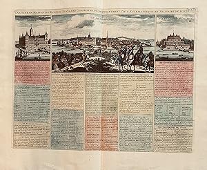
Contact seller5-star seller22 3/4 x 18 1/2 inches. This three hundred year old print presents the medals of good order in the French society of the early 18th century. Orders of knighthood in Christian royal society carried a message with each. They must have been quite impressive for your more accomplished knights in full dress uniforms. Very good condit…ion but trimmed close to the image by the original under lower left margin.

Published by Henri Chatelaine, Paris 1719
- Map
Seller: mediumraremaps.com, Franklin, TN, U.S.A.mediumraremaps.com
Contact seller5-star sellerCondition: Used - Very good
US$ 350.00
US$ 6.00 shippingShips within U.S.A.Quantity: 1 available
20 x 15 3/4 inches. Condition: Very good condition. This is a highly detailed copperplate engraving of eastern Russia and Northern China. The map goes from Korea in the southeast to Partie de Moscovie in the northwest. It goes from the Caspian in the southwest to the Pacific Ocean in the Northeast. China is prominently covered i…n the corpus of the eastern lands. The map indicates a Northeast Passage in the north. Overall, this is a very attractive map.

Published by Henri and Zaharias Chatelaine, Paris 1719
- Map
Seller: mediumraremaps.com, Franklin, TN, U.S.A.mediumraremaps.com
Contact seller5-star seller20 x 15 3/4 inches. Condition: Very good consdition. This is a finely engraved map of northeastern Africa and Saudi Arabia. The composition reflects the regional aspects of economy and culture. This was a comprehensive trade group with connections all the way to Persia. The Red Sea and Mediterranean provided avenues to the Persi…an Gulf and beyond. Egypt occupies the majority portion of the map. The kingdoms of the Upper Nile are well represented. This is a very nicely executed engraving with the ink offering a very good byte found in early impressions.

Published by Henri Chatelaine, Paris 1719
- Map
Seller: mediumraremaps.com, Franklin, TN, U.S.A.mediumraremaps.com
Contact seller5-star sellerCondition: Used - Very good
US$ 400.00
US$ 6.00 shippingShips within U.S.A.Quantity: 1 available
19 1/2 x 15 1/8 inches. Condition: Very good condition. This is an early pull of the plate based on the intensity of the engraving. There are 5 prints below the two page spread of the governments of the time. One is the secular entity. The other is the deity. The Grand Temple of Osaka is on small view in the lower right. It is c…omplemented by the city view in the lower left. There is a view of the torture of the Christians in mid left. The Japanese marriage ceremony is in the lower right. This is a finely composed insight into the culture and religion of Japan at the end of the seventeenth century and beginning of the eighteenth century. This present map is intense in its printing results and would make a very nice addition of any collection. It would also make a very nice gift for any recipient in Japan.


