Order Total (1 Item Items):
Shipping Destination:

Cluverius Philippus (66 results)
Skip to main search results
Search filters
Product Type
- All Product Types
- Books (25)
- Magazines & Periodicals (No further results match this refinement)
- Comics (No further results match this refinement)
- Sheet Music (No further results match this refinement)
- Art, Prints & Posters (6)
- Photographs (No further results match this refinement)
- Maps (35)
- Manuscripts & Paper Collectibles (No further results match this refinement)
Condition Learn more
Binding
- All Bindings
- Hardcover (19)
- Softcover (No further results match this refinement)
Collectible Attributes
- First Edition (1)
- Signed (No further results match this refinement)
- Dust Jacket (No further results match this refinement)
- Seller-Supplied Images (42)
- Not Print on Demand (57)
Language (2)
Free Shipping
Seller Location
Seller Rating
-

Africa Minor - Cyrenaica - Mauritania. Karte aus: Introductio in Universam Geographiam
Published by o.J. um 1660, 1660
Map
Condition: Befriedigend. Karte aus Cl�vers Werk 'Introductio in Universam Geographiam' ohne Jahr, um 1660. Dreigeteilte Darstellung mit der Tunesischen K�ste, der Cyrenaica und der Hauptkarte Mauretanien. Die Karte ist mittig gefaltet, am linken Rand mit Knickspuren und einem starken Fl�ssigkeitsfleck am oberen Eck rechts. Sprache / Language: la 1 Seiten. ca. 17,1 x 20,6 cm.
-
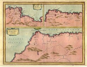
Africa Minor. / Mauritania.
Published by c., 1711
Seller: Robert Frew Ltd. ABA ILAB, London, United Kingdom
Association Member: ABA ILAB PBFA
Seller rating 5 out of 5 stars

Map
US$ 82.82
US$ 13.40 shipping
Ships from United Kingdom to U.S.A.Quantity: 1 available
Add to basket15.5 x 18.7 cm. Full colour. Three historical maps on one double page sheet. The main panel showing what is now Morocco and part of Algeria. Above this two maps showing the continuation of the Mediterranean coastline of Africa. Good condition.
-
Introductionis in Universam Geographiam tam veterem, quam novam libri sex illustrati et aucti. et P. Bertii Breviarium.
Published by Typ. Seminarii,, Patavii,, 1795
Seller: Studio Bibliografico Benacense, Riva del garda, TN, Italy
Seller rating 4 out of 5 stars

Cm. 15,5, pp. 348 (10) 50 (6). Con una tavola incisa in rame e ripiegata f.t. e 3 tavole sinottiche ripiegate. Legatura coeva in piena pergamena rigida con titoli al dorso. Esemplare in perfetto stato di conservazione. Il breviario del Berti appare in fine, con numerazione autonoma. Non comune edizione padovana di questo classico della letteratura geografica.
-
Philippi Cluverii Introductionis in universam geographiam, tam veterem quam novam libri VI. Accessit P. Bertij Breviarium orbis terrarium.
Published by Amstelodami, Apud Elzevirios [Elzevir], 1699., 1699
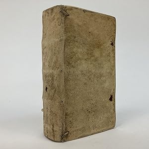
Couverture rigide. Condition: Tr�s bon. [Philip Cluwer ou Philippus Cluverius (1580-1622)] / [Pierre Bertius ou Petrus Bertius (1565-1629)] Philippi Cluverii Introductionis in universam geographiam, tam veterem quam novam libri VI. Accessit P. Bertij Breviarium orbis terrarium. Amstelodami, Apud Elzevirios [Elzevir], 1699. In-16, deux livre en un seul volume, reliure plein v�lin de l'�poque, dos lisse, titre manuscrit sur le dos, page de titre grav�e, 352 pages, une planche d�pliante hors-texte ; suivi de Petr. Bertio : Breviarium totius orbis terrarum, 70 pages, 6 feuillets hors-texte.
-
Introductionis in universam geographiam, tam veterem qu�m Novam Libri VI. Accessit P. Bertii Breviarium orbis terrarum.
Published by Venetiis apud Turrinum, 1646., Venezia, 1646
Seller: Libreria Antiquaria Gonnelli, Firenze, FI, Italy
Seller rating 4 out of 5 stars
Condition: Buono (Good). 0. In-12�, pagine 369 + 73 + carte [7]. Titolo inquadrato da cornice architettonica figurata. Legatura in pergamena molle coeva, titolo manoscritto al dorso. Insignif. fori di tarlo a poche cc. Bell'esemplare. Book.
-
Italia antiqua auctoris methodo, verbis et tabulis geographicis retentis (Philippi Cluverii)
Published by Guelferbyti: Buno; Wolfenbuttel, 1659
Seller: Sequitur Books, Boonsboro, MD, U.S.A.
Association Member: IOBA
Seller rating 5 out of 5 stars
Hardcover. Condition: Fair. 4to. 21 cm. Bound in contemporary calf. Spine ends chipped, front joint cracked. Solid binding. Wear to extremities. Substantial browning/toning to text. [12], 773 [i. e., 768], [44] pp. Engraved title. 4 folding engraved maps of Italy; folding bird's-eye view of Rome, at rear. Maps in good shape.
-
Philippi Cluverii Introductionis in Universam Geographiam tam Veterem quam Novam Libri VI. Tabulis aeneis illustrati. Accessit P. Bertii Breviarium Orbis Terrarum
Published by Amstelodami [Amsterdam]: Ex Officina Elzeviriana [Daniel Elzevir] 1661, 1661
Seller: Antikvariat Valentinska, Praha, Czech Republic
Association Member: ILAB
Seller rating 5 out of 5 stars
US$ 1,083.32
US$ 29.80 shipping
Ships from Czech Republic to U.S.A.Quantity: 1 available
Add to basketOne of the later editions of the "Introduction to Universal Geography", the first comprehensive modern geography, originally published in 1624-1629; it remained a standard work through the mid-18th century; the first of its six parts deals in general with the Earth, the remaining five contain short descriptions of countries and stress human and historical considerations. Written by Philipp Cl�ver (1580-1622), a Leiden-based German geographer, the founder of historical geography. This edition is supplemented with "Breviarium Totius Orbis Terrarum" and a survey of Roman emperors (short works by Petrus Bertius), followed by an index. The book features an engraved title page with putti and three figures of geographers. The copy contains a set of 4 fold-out plates (tables, diagrams) and 37 fold-out maps (copper engravings), both historical and modern, e.g. hemispheres, Europe, historical Roman provinces, Britain and Ireland, various European countries, various parts of Italy, Russia, Asia, China, India, Persia, Africa, America, various parts of the Middle East etc. Only a map of Galia is missing (torn away). Antiqua typeface; pages are decorated with headpieces and initials. The front endpaper and title leaf contain several ownership notes. /// Parchment binding (with handwritten title); hardback, [12]+388+[6]+[70] pp., 4 plates + 37 maps, 12� (7.5 x 13.5 cm), parchment discoloured and slightly worn, top edge darkened, fore edge with small ink stain, back hinge split, front free endpaper partly glued to front board, first plate with loss along bottom edge (diagram and text slightly corrupted), most pages, plates and maps with small narrow water stain along top edge, several maps with tear on folds, one map backed with small pieces of paper, one leaf's corner torn away (text slightly corrupted), last leaf partly detached, several leaves slightly worn along edges, other signs of wear and age are rare (minor creases and tears, small ink stain), one map missing, condition: good Book Language/s: Latin.
-
PHILIPPI CLUVERI INTRODUCTIONIS IN UNIVERSAM GEOGRAPHIAM, TAM VETEREM QUAM NOVAM. LIBRI VI; TABULIS AENEIS ILLUSTRATI. ACCESSIT P. BERTII BREVIARIUM TOTIUS ORBIS TERRARUM
Published by Guilielmum Broedelet, Rhenum, 1701
Seller: Second Story Books, ABAA, Rockville, MD, U.S.A.
Seller rating 4 out of 5 stars
Hardcover. 12mo; [12], 355, [83] pp. Original vellum. With engraved title page and 39 folding plates. VG; vellum discolored and age-toned, with some rubbing; interior clean and tight; all plates intact and crisp; MH Consignment; shelved case 3. 1335529. Shelved Dupont Bookstore.
-
Germania antiqua. Cum vindelicia et Norico auctoris methodo, verbis & tabulis Geogr. retentis contracta opera Johannis Bunonis acc. index rerum.
Published by Gvelferbyti Sumtibus Conradi Bunonis, Typis Johan. Henr. Dunckeri, (Wolfenb�ttel, C. Buno), 1663, 1663
Seller: Harteveld Rare Books Ltd., Marly, Switzerland
Association Member: ILAB VEBUKU
Seller rating 4 out of 5 stars
US$ 1,048.73
US$ 23.37 shipping
Ships from Switzerland to U.S.A.Quantity: 1 available
Add to basketin-4to, 34 Bl. + 752 S. + 59 Bl. (Index). Mit 6 (5 gefalt.) Kupfertafeln und 10 gefalt. Karten, Original-Lederband d. Zt. (Bezug etwas br�chig, mit kl. Fehlstellen, etwas best.). Kompendium germanischer Fr�hgeschichte. Cluver gilt als der Vater der historischen Geographie. - Etwas gebr�unt, leicht stockfleckig, Vors. leimschattig. Mit Karten von Deutschland, der Schweiz, Skandinavien usw. und Tafeln, die das Leben der alten Germanen darstellen. Exemplar ohne den gest. Titelblatt. Please notify before visiting to see a book. Prices are excl. VAT/TVA (only Switzerland) & postage. Vgl. Graesse 11, 204.
-

Philippi Cluveri Introductionis in universam geographiam, tam veterem quam novam. Libri VI; Tabulis aeneis illustrati & gemino indice aucti. Cui accessere Petr. Bertii Orbis Terrarum Breviarium, atque Danielis Heinsii Oratio in obitum ejusdem Philippi Cluveri. Accessit huic Editioni Index Locupletissimus omnium regionum, urbium, fluviorum, montium &c. [WITH] Breviarium Totius Orbis Terrarum
Published by Janssonio Waesbergios, Amsterdam, 1676
Seller: Sanctuary Books, A.B.A.A., New York, NY, U.S.A.
Seller rating 5 out of 5 stars
Hardcover. Condition: Very Good. Old panelled calf; 2 parts bound in 1 volume, small 4to (207x156mm); pp. [8] (including title-page printed in red and black), 142, plus 37 (of 46) engraved plates tipped onto stubs, double-page or folding maps by Peter van den Keere and Abraham Goos; [2] (title-page "Breviarium," blank), 31, [33] (index). Spine dry, with small tears and chips at tips; hinges cracked, and binding a bit shaken, but holding. Five maps loose (laid-in), and 2 tipped upside-down; but text block and plates are overall nice and clean, if occasionally a little dusty or thumbed along the very edges. While complete copies can be found in library holdings, most on the marketplace are (like this one), missing a few of the detailed and very cool (sea monsters!) maps. Text is complete, and the maps that remain show the world, Britain, Germany, Italy, Sardinia and Corsica, Crete, China, India, Palestine, and more.
-

Introductio in universam Geographiam . Tabulis geographicis XLVI ac notis ornata a Johanne Bunone.
Published by London: M. Jenour f�r J. Nicholson ,, 1711
Seller: Antiquariat Ruthild J�ger, Lueneburg, Germany
Seller rating 4 out of 5 stars
4�. 1 Blatt (17 x 23 cm). Schmaler Rand, etwas gebr�unt, sonst gut erhalten / slight browned, small margins, otherise in good state of conservation. * Titelblatt zu dem damals beliebten, seit 1697 mehrfach aufgelegten Geographie-Lehrbuch von Philipp Cluver, in der Londoner Ausgabe von J. Buno. Hier als Doppelblatt: rechts das Titelblatt, links das dekorative allegorische Kupferstich-Frontispiz (B. Lens sen. sc.) mit Allegorien auf die vier Weltteile.
-

Philippi Cluverii Introductionis in Universam Geographiam tam veterem, quam novam libri sex. Illustrati , & Aucti et P. Bertii, Breviarium.
Language: Latin
Published by Patavii, ex typographia Seminaarii, 1695
8� , Hardcover/Pappeinband. Titel, 4 Bl.,348 Seiten, 4 Bl. mit einer mehrfach gefaltetne Tafel und zwei Tabellen, Einband berieben, Bindung gelockert, keine losen B�gen, unbeschnitten, innen guter und sauberer Zustand. ------------------------------------------------ Philipp Cl�ver (auch Kl�wer, h�ufig latinisiert als Philippus Cluverius; * 1580 in Danzig; 31. Dezember 1622 in Leiden, Niederlande) war ein deutscher Geograph und Historiker, der starken Einfluss auf die Wiederbelebung der geographischen Wissenschaft in Europa hatte, und als Begr�nder der historischen Geographie gilt. Cl�ver n�herte sich der Geographie �ber die Geschichte und die klassischen Autoren. Zu seinen bedeutendsten Werken geh�rt die Introductio in Universam Geographiam (Einf�hrung in die universelle Geographie) von 1624. Der erste von sechs B�nden befasst sich im Allgemeinen mit der Erde, aber sein Ruhm begr�ndet sich mehr auf die �brigen f�nf B�nde. Sie enthalten kurze Beschreibungen der L�nder, mit Schwerpunkt auf einer menschlichen und historischen Betrachtung. Diese Introductio blieb bis zur Mitte des 18.Jahrhunderts ein Standardwerk der Geographie. la Gewicht in Gramm: 550.
-
Magna Graecia, Italiae antiquae pars.
Published by Germania,, 1670
Seller: libreria antiquaria perini Sas di Perini, Verona, VR, Italy
Seller rating 5 out of 5 stars
Art / Print / Poster
Incisione in rame di mm 180x210. Riquadro a sinistra raffigurante il golfo di Napoli. Philippus Cluverius (1580-1623), nato Philipp Cluever o Cluvier, � stato un geografo e storico tedesco. Buon esemplare, con tracce di pieghe editoriali e minimi segni di umidit? nella parte inferiore.
-
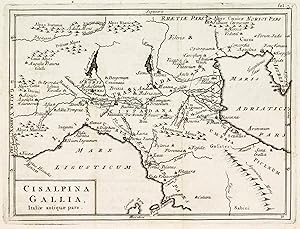
Cisalpina Gallia, Italiae antiquae pars
Published by Germania, 1670
Seller: libreria antiquaria perini Sas di Perini, Verona, VR, Italy
Seller rating 5 out of 5 stars
Art / Print / Poster
Incisione in rame di mm 165x220. Bella raffigurazione dell'Italia settentrionale. Philippus Cluverius (1580-1623), nato Philipp Cluever o Cluvier, � stato un geografo e storico tedesco. Buon esemplare, con tracce di pieghe editoriali. Nr.cat: 4978.
-
Italia propria.
Published by Germania,, 1670
Seller: libreria antiquaria perini Sas di Perini, Verona, VR, Italy
Seller rating 5 out of 5 stars
Art / Print / Poster
Incisione in rame di mm 165x215. Bella rappresentazione storica dell'Italia centrale. Philippus Cluverius (1580-1623), nato Philipp Cluever o Cluvier, � stato un geografo e storico tedesco. Buon esemplare, con tracce di pieghe editoriali.
-
Insulae Graeciae & Creta - Corsica et Sardinia.
Published by Germania, 1670
Seller: libreria antiquaria perini Sas di Perini, Verona, VR, Italy
Seller rating 5 out of 5 stars
Art / Print / Poster
Incisione in rame di mm 140x210. Due riquadri affiancati raffigurano rispettivamente l'arcipelago greco e le isole di Corsica e Sardegna. Philippus Cluverius (1580-1623), nato Philipp Cluever o Cluvier, � stato un geografo e storico tedesco. Buon esemplare, con tracce di pieghe editoriali.
-
Helvetia conterminarumq. terrarum antiqua descriptio
Published by Braunschweig, 1678
Seller: Libreria Ex Libris ALAI-ILAB/LILA member, Roma, RM, Italy
Seller rating 4 out of 5 stars
Map
Incisione originale su rame (cm. 25,5x20,5 pi� ampi margini bianchi). Ottimo esemplare.
-
Chersonesi quae hodie Natolia descriptio
Published by Braunschweig, 1678
Seller: Libreria Ex Libris ALAI-ILAB/LILA member, Roma, RM, Italy
Seller rating 4 out of 5 stars
Map
Incisione originale su rame (cm. 25,5x21 pi� ampi margini bianchi). Ottimo esemplare.
-
Daciarum, Moesiarum et Thraciae vetus et nova descriptio
Published by Braunschweig, 1678
Seller: Libreria Ex Libris ALAI-ILAB/LILA member, Roma, RM, Italy
Seller rating 4 out of 5 stars
Map
Incisione originale su rame (cm. 25x21 pi� ampi margini bianchi). Ottimo esemplare.
-
Hodiernae Belgicae sive Germaniae Inferioris tabula
Published by Braunschweig, 1678
Seller: Libreria Ex Libris ALAI-ILAB/LILA member, Roma, RM, Italy
Seller rating 4 out of 5 stars
Map
Incisione originale su rame (cm. 25,5x21 pi� ampi margini bianchi). Ottimo esemplare.
-
Sarmatia et Scythia, Russia et Tartaria Europaea
Published by Braunschweig, 1678
Seller: Libreria Ex Libris ALAI-ILAB/LILA member, Roma, RM, Italy
Seller rating 4 out of 5 stars
Map
Incisione originale su rame (cm. 25,5x24 pi� ampi margini bianchi). Ottimo esemplare.
-
Scythia et Tartaria Asiatica
Published by Braunschweig, 1678
Seller: Libreria Ex Libris ALAI-ILAB/LILA member, Roma, RM, Italy
Seller rating 4 out of 5 stars
Map
Incisione originale su rame (cm. 25,5x21 pi� ampi margini bianchi). Ottimo esemplare.
-
Vindeliciae et Norici, conterminarumq. terrarum antiqua descriptio
Published by Braunschweig, 1678
Seller: Libreria Ex Libris ALAI-ILAB/LILA member, Roma, RM, Italy
Seller rating 4 out of 5 stars
Map
Incisione originale su rame (cm. 25,5x20,5 pi� ampi margini bianchi). Ottimo esemplare.
-
Syriae sive Soriae descriptio
Published by Braunschweig, 1678
Seller: Libreria Ex Libris ALAI-ILAB/LILA member, Roma, RM, Italy
Seller rating 4 out of 5 stars
Map
Incisione originale su rame (cm. 25x20,5 pi� ampi margini bianchi). Ottimo esemplare.
-
Veteris et nova Pannoniae et Illyrici descriptio
Published by Braunschweig, 1678
Seller: Libreria Ex Libris ALAI-ILAB/LILA member, Roma, RM, Italy
Seller rating 4 out of 5 stars
Map
Incisione originale su rame (cm. 24,5x21 pi� ampi margini bianchi). Ottimo esemplare.
-
Germaniae Cisrhenanae ut inter I. Caesaris et Traiani fuit Imperia Scaldis item Mosae hac Rheni ostiorum antiqua descriptio
Published by Braunschweig, 1678
Seller: Libreria Ex Libris ALAI-ILAB/LILA member, Roma, RM, Italy
Seller rating 4 out of 5 stars
Map
Incisione originale su rame (cm. 25,5x25 pi� ampi margini bianchi). Ottimo esemplare.
-
Sicilia antiqua.
Published by Germania,, 1670
Seller: libreria antiquaria perini Sas di Perini, Verona, VR, Italy
Seller rating 5 out of 5 stars
Art / Print / Poster
Incisione in rame di mm 180x210. Riquadro in alto a sinistra raffigurante la Sicilia, le sue isole maggiori e la costa settentrionale dell'Africa. Philippus Cluverius (1580-1623), nato Philipp Cluever o Cluvier, � stato un geografo e storico tedesco. Buon esemplare, con tracce di pieghe editoriali.
-
Africa antiqua et nova
Published by Braunschweig, 1678
Seller: Libreria Ex Libris ALAI-ILAB/LILA member, Roma, RM, Italy
Seller rating 4 out of 5 stars
Map
Incisione originale su rame (cm. 26x22 pi� ampi margini bianchi). Ottimo esemplare.
-
Indiae Orientalis et Insularum adiacentium antiqua et nova descriptio
Published by Braunschweig, 1678
Seller: Libreria Ex Libris ALAI-ILAB/LILA member, Roma, RM, Italy
Seller rating 4 out of 5 stars
Map
Incisione originale su rame (cm. 26,5x22 pi� ampi margini bianchi). Ottimo esemplare.
-
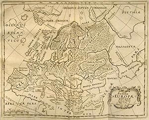
Nova totius Germaniae descriptio
Published by Braunschweig, 1678
Seller: Libreria Ex Libris ALAI-ILAB/LILA member, Roma, RM, Italy
Seller rating 4 out of 5 stars
Map
Incisione originale su rame (cm. 33x26,5 pi� ampi margini bianchi). Ottimo esemplare.